Wikimedi'Òc
Modes d'emploi

Cet album fait partie des albums
Cet album photos contient les sous-albums suivants :


New South Wales, Australia 1904.jpg - Marsonmars

Cairns, Austalia 1946.jpg - Marsonmars

Wollongong, Queensland, Australia 1950.jpg - Marsonmars

Map of Werunda Country in NSW from 1876.png - Returned dude12345
Old parish map of New Mountain Rush.tif - Swilter

Newcastle-Maitland 1918.jpg - Marsonmars

Map-533.jpg - Rama

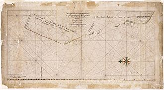
New Holland map by William Dampier 1699 - Project Gutenberg eText 15675.jpg - Tagishsimon

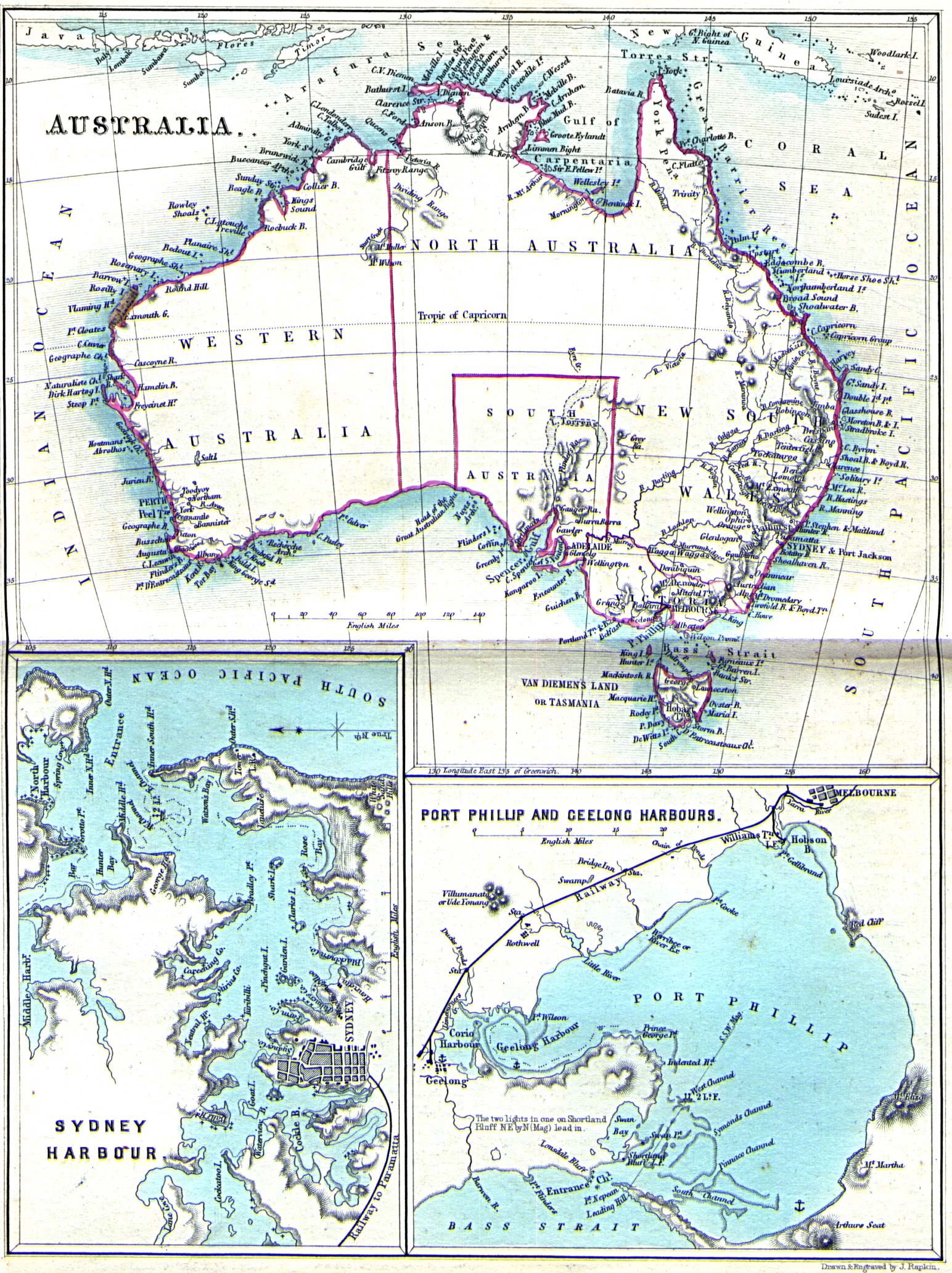
LA2-NSRW-1-0177.jpg - File Upload Bot (LA2)

Australien, karta, Nordisk familjebok.jpg - Väsk
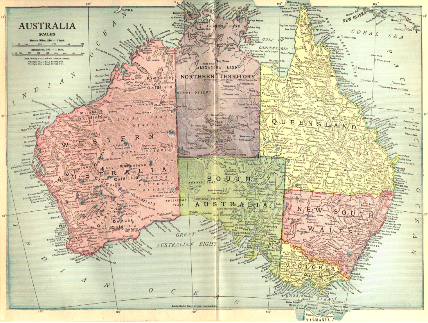
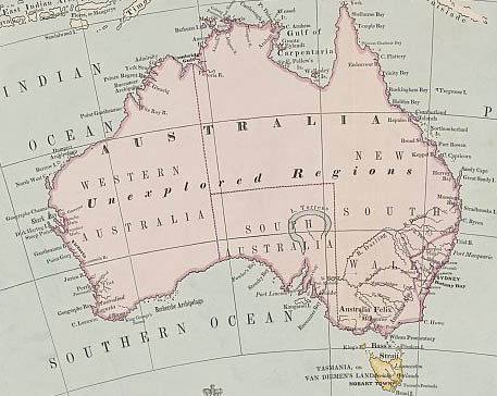
NSRW Map of Australia.png - Bookofjude

Sturt and Hume and Hovell expeditions.jpg - PDH

Australien 1905.png - Kogo

Meyers b2 s0144a.jpg - Mapmarks

Gulf-of-Carpentaria-Australia-Otto-Petri-1859-Rotterdam.jpg - Bejnar

Stielers Handatlas 1891 72.jpg - Kolossos

Stielers Handatlas 1891 73.jpg - Kolossos
Australia 1860.jpg - Roke~commonswiki

RobertDixonMoretonBay.jpg - CaliforniaAliBaba

RobertDixonGippsland.jpg - CaliforniaAliBaba

ACT area Murray County 1886.jpg - Roke~commonswiki

Australien, karta, Nordisk familjebok Kap Leeuwin.jpg - Ibn Battuta

Globe Coronelli Map of New Holland.jpg - TCY
Australia map 1863.jpg - Roke~commonswiki

Desceliers 1550 map - Australia detail.jpg - Hesperian

Londe of Java.jpg - Hesperian

Java La Grande.jpg - Hesperian

Caert van't Landt van d'Eendracht (NLA balanced).jpg - Hesperian
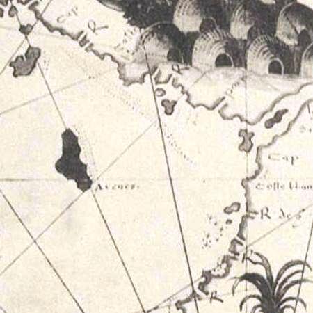
Desceliers 1550 map - detail showing Arenes.jpg - Hesperian
Globe terrestre de Jacques Vau de Claye (1583).gif - Parigot

Hessel Gerritsz - Malay Archipelago and Australia.jpg - Jan Arkesteijn

Van Keulen-Nieuwe Pascaert van Oost Indien-1680-1735-2.png - Benedikt.Seidl

Australia 1900.jpg - Sasha Krotov

Arnold Guyot03.jpg - Rotational~commonswiki

Brockhaus and Efron Encyclopedic Dictionary b1 090-1.jpg - ButkoBot

Ludwig Leichhardt6.jpeg - Ephraim33

Early voyages to Terra Australis - map facing p.37.jpeg - Cygnis insignis
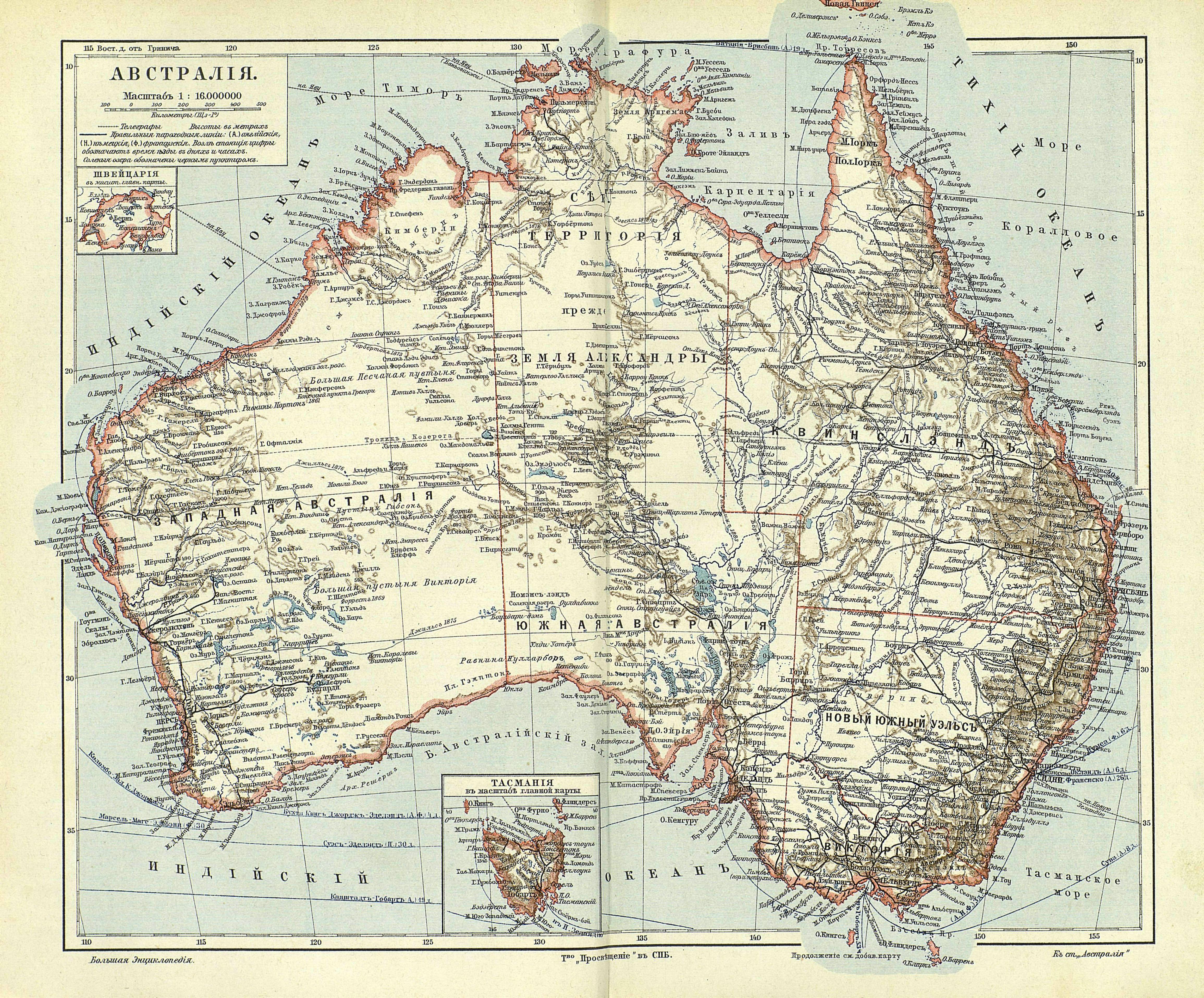
Yuzhakov Big Encyclopedia Map of Australia.jpg - Small Bug

115 australien-festland (1905).png - 14nu5

Itinéraire du Caitaine Cook.JPG - Toubabmaster~commonswiki

'Mistress Branican' by Léon Benett 35.jpg - Electron

'The Children of Captain Grant' by Édouard Riou 117.jpg - Geagea

Maslens Inland Sea of Australia.jpg - Prosfilaes
Wallace Island Life p497.png - Keith Edkins

1876 Stieler's Map of Southeastern Australia - Geographicus - AustraliaEast-s-76.jpg - BotMultichill

Sketch Map of Gippsland - Showing approximately the Positions of the Clans of the Kurnai Tribe.jpg - Misarxist

Royal-geographical-society geographical-journal 1914 macquarie-island-antarctica 1381 2000 600.jpg - CSvBibra

PikiWiki Israel 15147 JNF box in Australia Park in Misgav.JPG - Pikiwikisrael

Henry de Freycinet and Australian Governor-General.jpg - Rupert Gerritsen
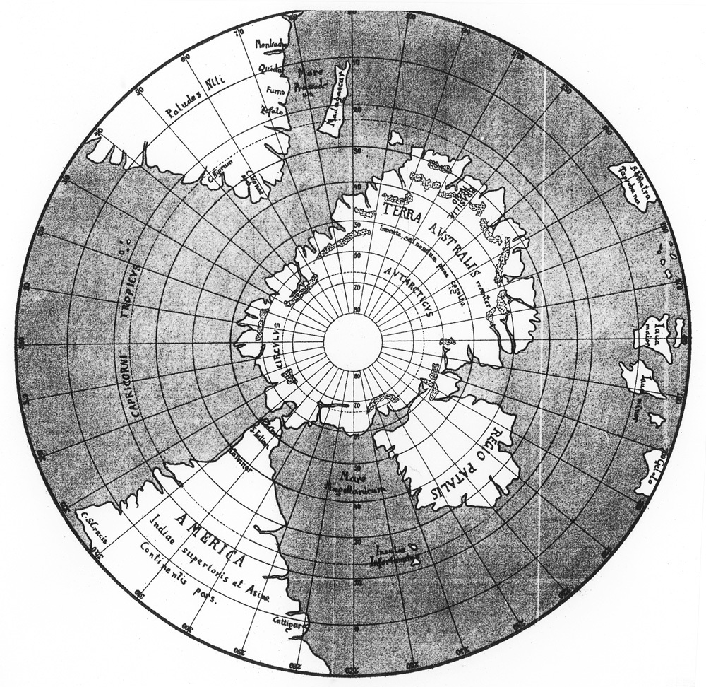
Johannes Schöner, globe of 1533, southern hemisphere.jpg - Kattigara
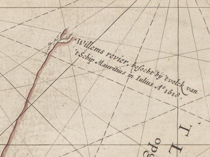
Caert van't Landt van d'Eendracht (detail showing Willems River).jpg - KHS-Boab

State Library of New South Wales000.jpg - Eugenio Hansen, OFS

Vallard Australia-1547d.jpg - Mcapdevila

Australia in 1794 Samuel Dunn Map of the World in Hemispheres.JPG - Alborzagros

Map of Glenelg East 1936.JPG - Eurekaone
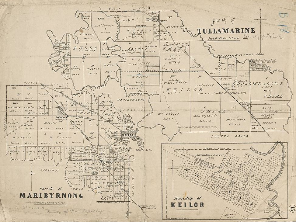
Parishes of Tullamarine and Maribyrnong 1892.jpg - Lankiveil

Brisbane Town 1840.jpg - Lankiveil

Somerset, Albany Island.jpg - Pvladko

Nineteen counties, Australia, 1832.jpg - Pvladko

Vintage Map of Australia 1817.jpg - Sublime101

Australia1848.jpg - National Public Domain Archive

Sydney Cove Port Jackson 1788 Fowkes.jpg - AnonMoos

StateLibQld 2 107716 Coorparoo Heights Estate map, 1916.jpg - SLQbot

StateLibQld 2 119336 Map of the town of Mount Isa, 1935.jpg - SLQbot

StateLibQld 2 131715 Map of Cairns' wharves, 1876.jpg - SLQbot

StateLibQld 2 150383 Plan of sections no. 1 to 30, township of Cairns, district of Cook.jpg - SLQbot

StateLibQld 2 175235 Map of Orient House Estate at Sutton's Beach, Redcliffe, 1929.jpg - SLQbot

StateLibQld 2 191855 Estate map for Pacific Ocean Estate, Southport, 1915.jpg - SLQbot

StateLibQld 2 200851 Estate map of the Vaughan Estate, Redcliffe, 1890-1900.jpg - SLQbot

StateLibQld 2 200987 Map of Woodford in the Parish of Durundur, 1904.jpg - SLQbot

P033 - N° 527. D’Adélaïde à Sydney. - Liv4-Ch05.png - Vieux têtard

NW Australia 1885.jpg - Geagea
Preserving Archipelagus Orientalis.ogv - Wittylama
1911 Britannica - Map of Australia1.png - Clarice Reis

1911 Britannica - Map of Australia2.png - Clarice Reis

New Hydrographic Map of the Sea and New Southern Lands- Made by the Cosmographer and Mathematician Emanuel Godinho de Eredia WDL852.png - Hzh
A new and accurate map of New South Wales, with Norfolk and Lord Howes Islands, Port Jackson etc from actual surveys. NYPL1404035.tiff - Fæ

AMH-8089-KB Map of Australia.jpg - HuskyBot
(1897) OZEANIA.jpg - Metilsteiner

Universiteitsbibliotheek VU - Map shewing the route and discoveries of the Calvert Exploring Expedition in Western Australia.jpg - Spinster

Universiteitsbibliotheek VU - Map shewing the route and discoveries of the Calvert Exploring Expedition in Western Australia (cropped).jpg - Spinster

HARVEN(1883) p026 CONTINENT AUSTRALIA.jpg - Metilsteiner

Old Australia map in german.jpg - Hoa binh

Archives des missions scientifiques et littéraires (1881) (19130814594).jpg - Fæ

Archives des missions scientifiques et littéraires (1881) (19753400635).jpg - Fæ

Révai nagy lexikona; az ismeretek enciklopédiája (1911) (14597938099).jpg - Fæ

Révai nagy lexikona; az ismeretek enciklopédiája (1911) (14761602916).jpg - Fæ

The Australian zoologist (1934) (20350220795).jpg - SteinsplitterBot

Histoire générale des voyages, ou, Nouvelle collection de toutes les relations de voyages par mer et par terreposées sur les observations les plus autentiques (1746) (14595824677).jpg - Fæ

FMIB 36089 Distribution of Retropinna semoni.jpeg - BMacZeroBot

The Emu - official organ of the Australasian Ornithologists' Union (1909) (20669755954).jpg - SteinsplitterBot

The commonwealth of Australia; federal handbook, prepared in connection with the eighty-fourth meeting of the British association for the advancement of science, held in Australia, August, 1914 (1914) (14586676630).jpg - SteinsplitterBot

The Great Barrier Reef of Australia (Plate) (6898578584).jpg - Fæ

FMIB 36616 Map of Port Stevens.jpeg - BMacZeroBot

FMIB 36625 Map of Broken Bay, Including Pitt and Brisbane Waters.jpeg - BMacZeroBot

The Catholic encyclopedia; an international work of reference on the constitution, doctrine, discipline, and history of the Catholic Church (1907) (14759957501).jpg - SteinsplitterBot

Histoire générale des voyages ou Nouvelle collection de toutes les relations de voyages par mer et par terre, qui ont été publiées jusqu'à présent dans les différentes langues de toutes les nations (14771957024).jpg - Fæ

The commonwealth of Australia; federal handbook, prepared in connection with the eighty-fourth meeting of the British association for the advancement of science, held in Australia, August, 1914 (1914) (14586893417).jpg - SteinsplitterBot

The commonwealth of Australia; federal handbook, prepared in connection with the eighty-fourth meeting of the British association for the advancement of science, held in Australia, August, 1914 (1914) (14793240183).jpg - SteinsplitterBot

The commonwealth of Australia; federal handbook, prepared in connection with the eighty-fourth meeting of the British association for the advancement of science, held in Australia, August, 1914 (1914) (14586620420).jpg - SteinsplitterBot

The commonwealth of Australia; federal handbook, prepared in connection with the eighty-fourth meeting of the British association for the advancement of science, held in Australia, August, 1914 (1914) (14771028744).jpg - SteinsplitterBot

Nests and eggs of Australian birds, including the geographical distribution of the species and popular observations thereon (1901) (14563504078).jpg - SteinsplitterBot

An empire story; stories of India and the greater colonies told to children (1908) (14770526475).jpg - SteinsplitterBot

Meyers Konversations-Lexikon - eine Encyklopädie des allgemeinen Wissens (1890) (14763551071).jpg - Fæ

Meyers Konversations-Lexikon - eine Encyklopädie des allgemeinen Wissens (1890) (14764369394).jpg - Fæ

Vselennaia - razskazy iz fizicheskoi, matematicheskoi i politicheskoi geografii dlia chitatelei ot 8 do 12 liet (1863) (14578679877).jpg - SteinsplitterBot

The commonwealth of Australia; federal handbook, prepared in connection with the eighty-fourth meeting of the British association for the advancement of science, held in Australia, August, 1914 (1914) (14771009254).jpg - Fæ

A sketch of the natural history of Australia BHL43165813.jpg - SteinsplitterBot
Pinkerton Map 1818 - Recolour v1.6.tif - Count.Zilch

Sketch of the proposed route from Sydney to Port Essington (14086132064).jpg - Fæ

Map of Australia - The boundaries of the Colony as set forth in the present commission of the Governor General are shewn by a red edging and embrace 760 millions of acres (Sketch book 8 folio 54) (23032671764).jpg - Fæ

Australia - The red edging shews that portion of the N.S. (New South) Wales territory which the South Australian Gov't (Government) have proposed should be acceded to that Colony (24274594522).jpg - Fæ

Recherche Archipelago map 1792 nla.obj-230811677-1.jpg - Ratzer

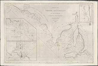
Matthew Flinders - General chart of Terra Australis or Australia.jpg - Christallkeks

The Overflow Parish 1880.png - D A R C 12345

A new Fleuron N042026-3.png - Fæ

Jeugdhal in Energiehal. Voorlichting politie, Bestanddeelnr 912-7450.jpg - Mr.Nostalgic
Nla.obj-234332820.tif - Aliaretiree

Carte de la Nouvelle Hollande et de quelques terres voisines (34423193701).jpg - Junior Jumper

Image taken from page 8 of 'A First Fleet Family. A hitherto unpublished narrative of certain remarkable adventures compiled from the papers of Sergeant William Dew of the Marines, by Louis Becke and Walter Jeffery' (16588526461).jpg - Artix Kreiger 2

8 of 'Sydney and Melbourne; with remarks on the present state and future prospects of New South Wales, and practical advice to emigrants of various classes, etc. (With a map.)' (11023619795).jpg - Artix Kreiger 2

582 of 'The Australian Race- its origin, languages, customs, place of landing in Australia, and the routes by which it spread itself over that continent' (11184467236).jpg - Artix Kreiger 2

89 of 'Enterprise in Tropical Australia. (With maps.)' (11025337215).jpg - Artix Kreiger 2

285 of 'La Terra, trattato popolare di geografia universale per G. Marinelli ed altri scienziati italiani, etc. (With illustrations and maps.)' (11291311384).jpg - Artix Kreiger 2

26 of 'La Nouvelle Zélande. Histoire ... Avec cartes et planches' (11163746505).jpg - Kilom691

399 of 'The Black Police. A story of modern Australia, etc' (11210896746).jpg - FlickreviewR 2

3 of '(A Handbook to the Colony of New South Wales. (With a map.))' (11059131225).jpg - Artix Kreiger 2

3 of '(A Handbook to the Colony of South Australia. (With a map.))' (11058283714).jpg - Artix Kreiger 2

3 of '(A Handbook to the Colony of Victoria, Australia. (With a map.))' (11056849714).jpg - Artix Kreiger 2

22 of 'Travelling About over New and Old Ground, etc' (11097164386).jpg - FlickreviewR 2

22 of '(Travelling About over New and Old Ground, etc.)' (11161390436).jpg - FlickreviewR 2

19 of 'Adventures in Australia Fifty Years ago. Being a record of an emigrant's wanderings through the colonies of New South Wales, Victoria and Queensland during the years 1839-1844. (With a map.)' (11220671726).jpg - Artix Kreiger 2

304 of 'Le Continent austral. Hypothèses et découvertes' (11302611806).jpg - Artix Kreiger 2

387 of 'Le Continent austral. Hypothèses et découvertes' (11220439016).jpg - FlickreviewR 2

10 of 'Matthew Flinders; or, How we have Australia. Being the true story of Captain Flinders' explorations and adventures, etc' (11236234416).jpg - FlickreviewR 2

31 of 'The Native Tribes of Central Australia. (With illustrations.)' (11253680454).jpg - Artix Kreiger 2

411 of 'The Native Tribes of Central Australia. (With illustrations.)' (11254049154).jpg - Artix Kreiger 2
Map - Special Collections University of Amsterdam - OTM- HB-KZL 31-01-28.tif - DeJong2332
Carte de l'Australie. LOC 00556401.tif - Fæ

Carte de l'Australie. LOC 00556401.jpg - Fæ

1833 fremantle townsite plan.jpg - Adondai

U.S. Foreign Service posts, Bureau of East Asian and Pacific Affairs (EA). 12-71. LOC 75690926.jpg - Fæ
Plan of Canberra, the Federal Capital of the Commonwealth of Australia LOC 2006629794.tif - Fæ

Plan of Canberra, the Federal Capital of the Commonwealth of Australia LOC 2006629794.jpg - Fæ
Australia. LOC 00552796.tif - Fæ

Australia. LOC 00552796.jpg - Fæ
Australia. LOC 00552797.tif - Fæ

Australia. LOC 00552797.jpg - Fæ
Carapook, county of Dundas - (located in state of Victoria). LOC 2008624021.tif - Fæ

Carapook, county of Dundas - (located in state of Victoria). LOC 2008624021.jpg - Fæ

Charts Showing Humidity, also Wet and Dry Bulb Isotherms Fig 53-54.png - Sp1nd01
Map of South Australia, New South Wales, Van Diemens Land, and Settled parts of Australia LOC 2018588005.tif - Fæ

Map of South Australia, New South Wales, Van Diemens Land, and Settled parts of Australia LOC 2018588005.jpg - Fæ

Südliche Oberflaeche der Erde.jpg - Higgenhorscht

Festland von Australien und benachbarte Inseln.jpg - Higgenhorscht

Süd-Östliches Australien.jpg - Higgenhorscht
Illustration from The Great Barrier Reef of Australia (1893) by William Saville-Kent from rawpixel's own original publication 00001.jpg - Rawpixel

New South Wales South East1952 subdivision map.jpg - Ratzer

Le Tour du monde-02-p187.jpg - Bzhqc

Älteste Generalkarte Australiens von Freycinet 1811 verbessert.jpg - Petermichaelgenner

Le Tour du monde-03-p091.jpg - Bzhqc

Ilustración del Atlas Vallard.jpg - Jl FilpoC

Map of Australia(GN00265).jpg - Htsa

Map of Australia(GN00264).jpg - Htsa

Admiralty Chart No 1044 North Coast of Australia Sheet IV, Published 1825.jpg - Kognos

Admiralty Chart No 2759b Australia southern portion, Published 1885.jpg - Kognos

Admiralty Chart No 2763 Australia, Coral Sea and Great Barrier Reefs. Sheet 1, Published 1860.jpg - Kognos

Admiralty Chart No 1066 Chart of Terra Australis. sheet 1 East coast, Published 1814.jpg - Kognos

Admiralty Chart No 1067 Chart of Terra Australis. Sheet II, East coast, Published 1814.jpg - Kognos

Admiralty Chart No 1068 Chart of Terra Australis. Sheet III East coast, Published 1814.jpg - Kognos

Admiralty Chart No 1059 Chart of Terra Australis. Sheet I South coast, Published 1814.jpg - Kognos

Admiralty Chart No 1061 Chart of Terra Australis. Sheet III South coast, Published 1814.jpg - Kognos
Admiralty Chart No 1075 Chart of part of the N.E. coast of Australia. Sheet 1, Published 1824.jpg - Kognos

Admiralty Chart No 748c Map of Eastern Australia including Tasmania with New Guinea, Caroline Islands and the Mariana Islands, Published ca 1875.jpg - Kognos

1938 Index to Admiralty charts of Australia nla.obj-574968257.jpg - Kognos

1938 Index to Admiralty charts of Torres Strait, Brisbane, Sydney, Adelaide, Fremantle, Bass Strait and Tasmania nla.obj-574968437.jpg - Kognos

Admiralty Chart No 1088 Arafura Sea, Published 1837.jpg - Kognos

Admiralty Chart No 567 Australia, New South Wales, Jervis Bay, Published 1895.jpg - Kognos

Chart of the Malay Archipelago Dutch discoveries in Australia 1618.jpg - Eothan

Admiralty Chart No 475 North West Coast of Australia, Published 1880.jpg - Kognos
"THIBET" (Tibet), "CHINA" and "HINDOOSTAN" (India) map detail, from- Modern Asia (1796) (cropped).tif - Tibet Nation

БСЭ1. Австралийская Федерация 2.jpg - Lozman

Харківський морський музей 17.jpg - Завгородня Вероніка

General-Karte von Australien (13 Auflage) - bearbeitet und gezeichnet von F. Handtke... - btv1b530251468.jpg - Gzen92Bot

Australie d'après J. Bartholomew... - revue d'après les documents les plus récents et dressée au point de vue géologique par F. Journet... - btv1b530226625.jpg - Gzen92Bot

Australie. - General Map of Australia, showing the routes of the explorers. Reduced and drawn by Edward Price - btv1b530253249.jpg - Gzen92Bot

Australie et Nouvelle Zélande - btv1b530089619.jpg - Gzen92Bot

Vollstandiger Hand-Atlas der neueren Erdbeschreibung uber alle Theile der Erde in 82 Blattern 1858 (99241095).jpg - Polona Upload
NSRW Map of Australia (cropped).png - JPxG