Wikimedi'Òc
Modes d'emploi

Cet album fait partie des albums
Cet album photos contient les sous-albums suivants :


Hollandia nova detecta 1644 - btv1b5963434d.jpg - Gzen92Bot
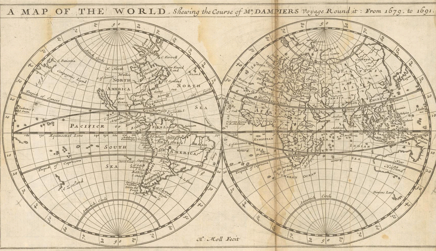
Moll - A map of the world shewing the course of Mr Dampiers voyage round it from 1679 to 1691.png - Frank Schulenburg

NovaGuinea1600map.jpg - CJLL Wright

Tasmanmap1644.jpg - Gobeirne

Burgerzaal - Australië.JPG - Fentener van Vlissingen

1744 Bowen Map of the World in Hemispheres - Geographicus - World-bowen-1744.jpg - LlywelynII

Nova Archipelagi Orientalis Tabula Joan Blaeu 6663.png - Camira

Orbis vetus in utrâque continente juxtà mentem Sansonianam distinctus, nec non observationibus astronomicis - Norman B. Leventhal Map Center at the BPL.jpg - Dzlinker

Amsterdam Royal Palace P1080013.JPG - SteinsplitterBot

Mappemonde ou Description du globe terrestre (4072626326).jpg - File Upload Bot (Magnus Manske)

AMH-7220-KB Map showing the route taken by Abel Tasman.jpg - HuskyBot

AMH-8032-KB Map of the Pacific Ocean, with Australia and the west coast of South America.jpg - HuskyBot

AMH-5135-NA Map of the Indies archipelago.jpg - HuskyBot

AMH-5546-NA Map showing the journeys of Abel Tasman.jpg - HuskyBot

AMH-6426-NA Map showing the coasts of New Guinea.jpg - HuskyBot

L'Epitome du Theatre de l'Univers d'Abraham Ortelius - La terre universelle.jpg - Reginadelmondo

Bowen- A Complete map of the Southern Continent.jpg - Holapaco77

Vaugondy, Gilles Robert De — Orbis Vetus in utraque continente juxta mentem Sansonianam distinctus, nec non observationibus astonimicis redactus 1752.jpg - Mattes

A new map of the terraqueous globe according to the latest discoveries and most general divisions of it into continents and oceans (NYPL b15114268-1630698).jpg - Fæ

"Mapa mundi en Portada" (26344154326).jpg - Tm
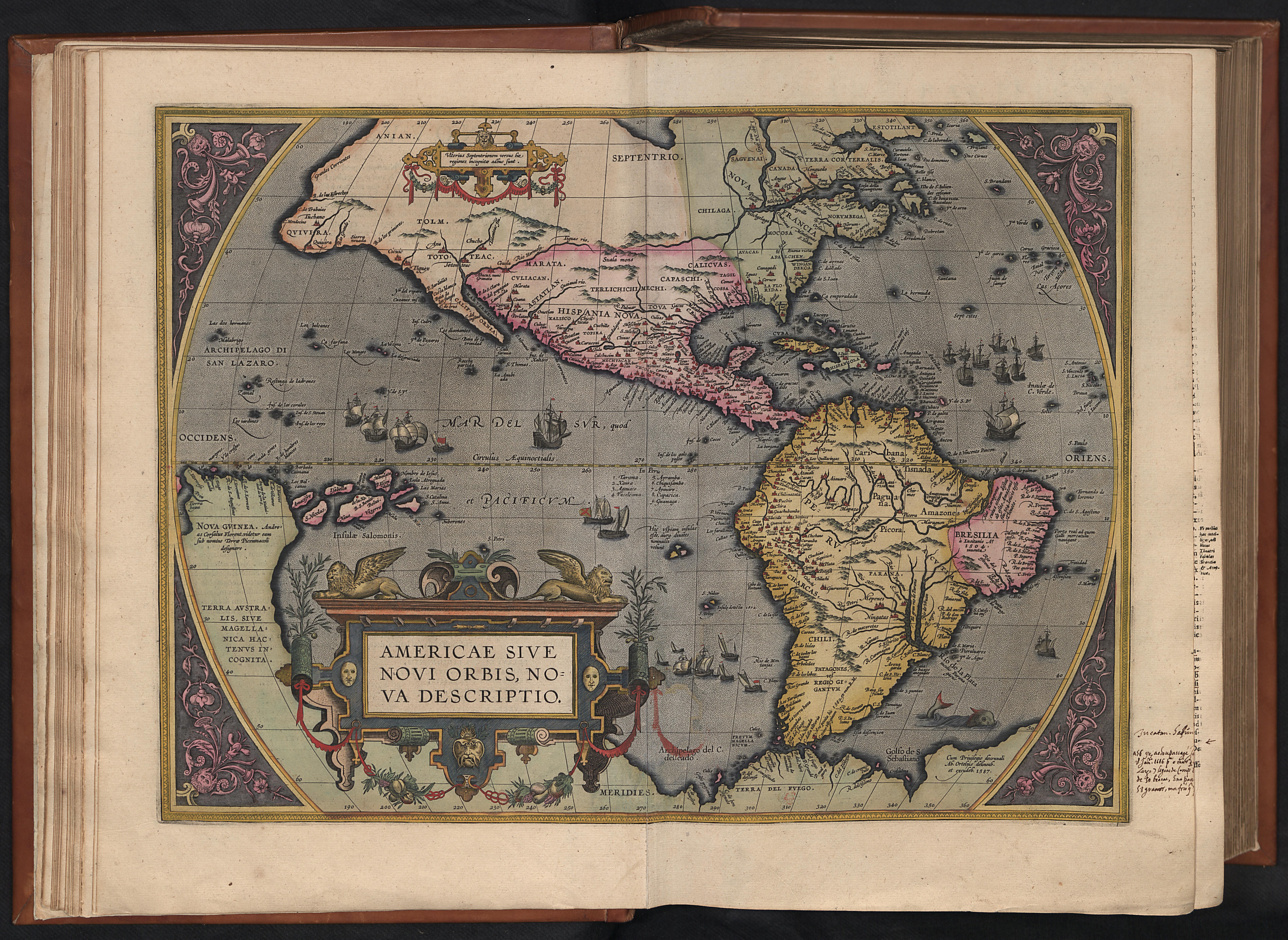
Ortelius America.jpg - Bcubantwerpen
A new and correct map of the world, laid down according to the newest discoveries, and from the most exact observations, by Herman Moll, Geographer. RMG F0475.tiff - Fæ

129 of 'Das neue Buch der Reisen und Entdeckungen. O Spamer's illustrirte Bibliothek der Länder & Völkerkunde, etc. (Unter redaktion von F. von Hellwald und R. Oberländer.) vol. 1' (11245652285).jpg - Artix Kreiger 2
Map - Special Collections University of Amsterdam - OTM- HB-KZL 31-01-28.tif - DeJong2332

A map of the world with ships DUKE & DUTCHESS' tract round it from 1708 to 1711, by Herman Moll, geographer LCCN2007677057.jpg - Fæ

1757 – G. R. Vaugondy – Orbis Vetus.jpg - Poli.Pav

Ca. 1750 Japanes world map - Chiku Bankoku Ichizan no Zu - Comprehensive Image of the World's Myriad Countries.jpg - Balkanique

B26055990C - Nova tabvla India Orientalis.jpg - NLSingapore

Carte physique de la Grande Mer - ci-devant nommée Mer du Sud ou Pacifiq́ue; oú se voient les grandes chaǐnes de montagnes (MAPS 97).jpg - BMacZeroBot

Orbis Vetus in utrâque continente juxta mentem Sansonianam distinctus, nec non observationibus astronomicis redactus accurante Robert de Vaugondy... - btv1b5962753g.jpg - Gzen92Bot

India quae Orientalis dicitur et insulae adiacentes - btv1b525051494 (3 of 4).jpg - Gzen92Bot

Vies des gouverneurs généraux avec l'abrégé de l'histoire des établissements hollandois aux Indes orientales... - orné de leurs portraits en vignettes au naturel - par J. P. I. Dubois - btv1b525113184 (174 of 485).jpg - Enyavar

Harmonia Macrocosmica Seu Atlas Universalis Et Novus. 13, Hemisphaerium Orbis Antiqui, Cumzonis, Circulis, et situ populorum diverso - I. van Loon fec - bpt6k9106296h.jpg - Gzen92Bot

Nouvel atlas de Marine composé d'une carte générale, et de XII cartes particulières, qui représentent le globe terrestre jusqu'au 82e degré du côté du nord, et jusqu'au 60e du côté du Sud. Le... - btv1b5970588n (21 of 23).jpg - Gzen92Bot

Atlas portatif, universel et militaire, composé d'après les meilleures cartes, tant gravées que manuscrites, des plus célébres géographes et ingénieurs. Tome 2 - . Par M. Robert, geographe... - bpt6k1510920h (022 of 409).jpg - Gzen92Bot

Mappemonde dressée suivant les nouvelles relations et assujettie aux observations astronomiques - par le Sr Robert... - btv1b53093290h.jpg - Gzen92Bot

Typus orbis terrarum - Arnoldus F. ab Langren, auth. et scalp. - btv1b8490572r.jpg - Gzen92Bot

Orbis vetus in utraque continente juxta mentem Sansonianam... - accurante Robert de Vaugondy... - btv1b53093791v.jpg - Gzen92Bot

Map of Australia.jpg - Baddu676

Australiane.jpg - Baddu676

A new and correct map of the world laid down according to the newest discoveries and from the most exact observations.png - Austiger

Kaart der Reyse van Abel Tasman volgens syn eygen opstel.png - Austiger

EB1 Plate LXXXVII Fig. 2 World.png - LlywelynII
Taboas Geraes de Toda a Navegacao.tif - LlywelynII

Great Burgerzaal Map and Celestial Map.jpg - LlywelynII

Great Burgerzaal Map.png - LlywelynII
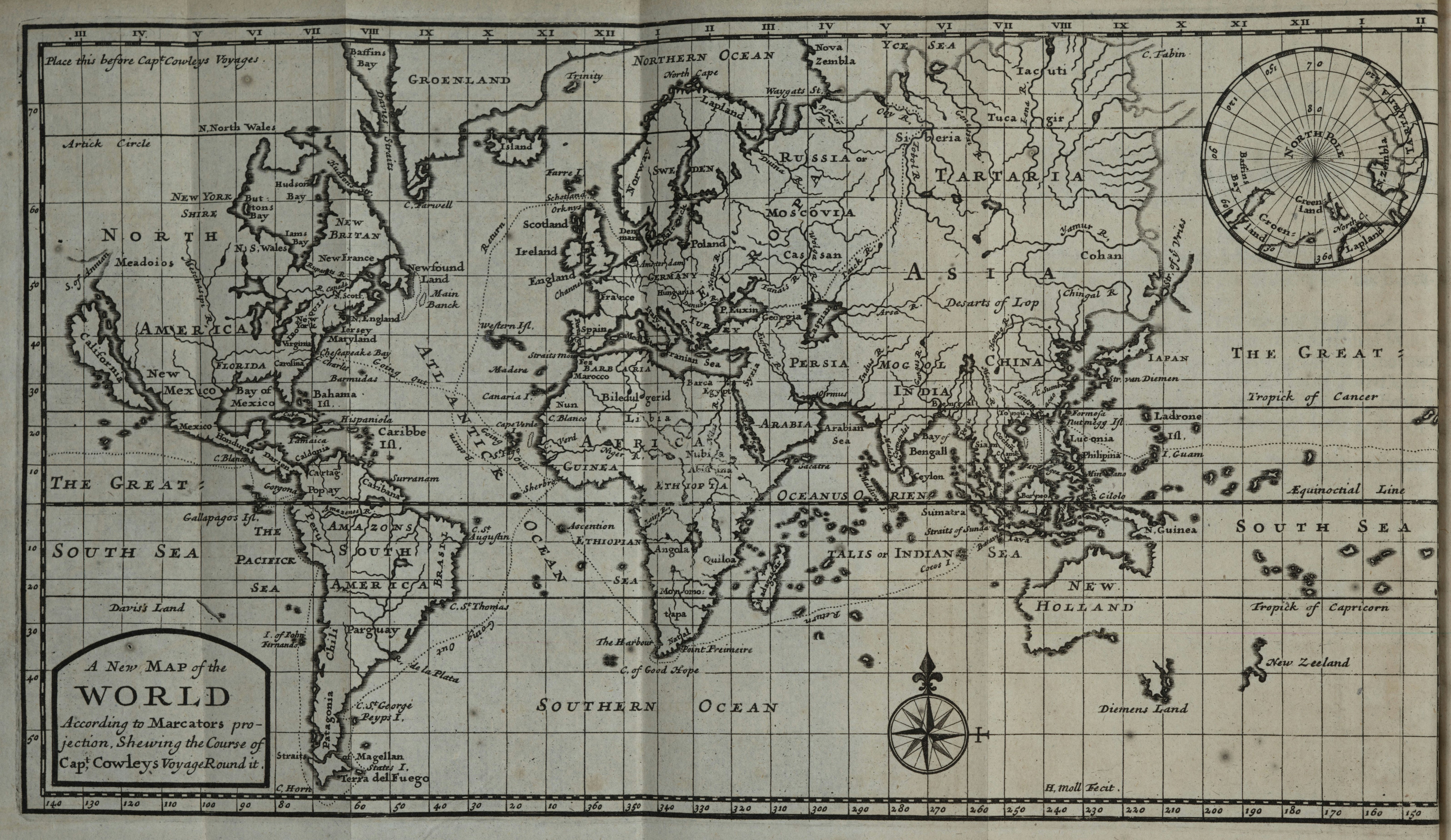
Cowley's Circumnavigation 1699.jpg - LlywelynII