Wikimedi'Òc
Modes d'emploi

Cet album fait partie des albums
Cet album photos contient les sous-albums suivants :


Halesworthmap 1921.jpg - Geni

Harlestonmap 1921.jpg - Rotatebot

Bognor regismap1945s.jpg - Rotatebot

St hellensmap1947.jpg - Rotatebot

Y Gogledd.jpg - Yrithinnd

Built up bit from london NW OS map 1944.jpg - Geni

New popular edition map numbers.jpg - Geni
The History of CRGS Map (page 2).png - Jarry1250
The History of CRGS Map (page 8).png - Jarry1250

London.png - BotMultichillT

The National Archives UK - CO 1069-202-3.jpg - M.casanova
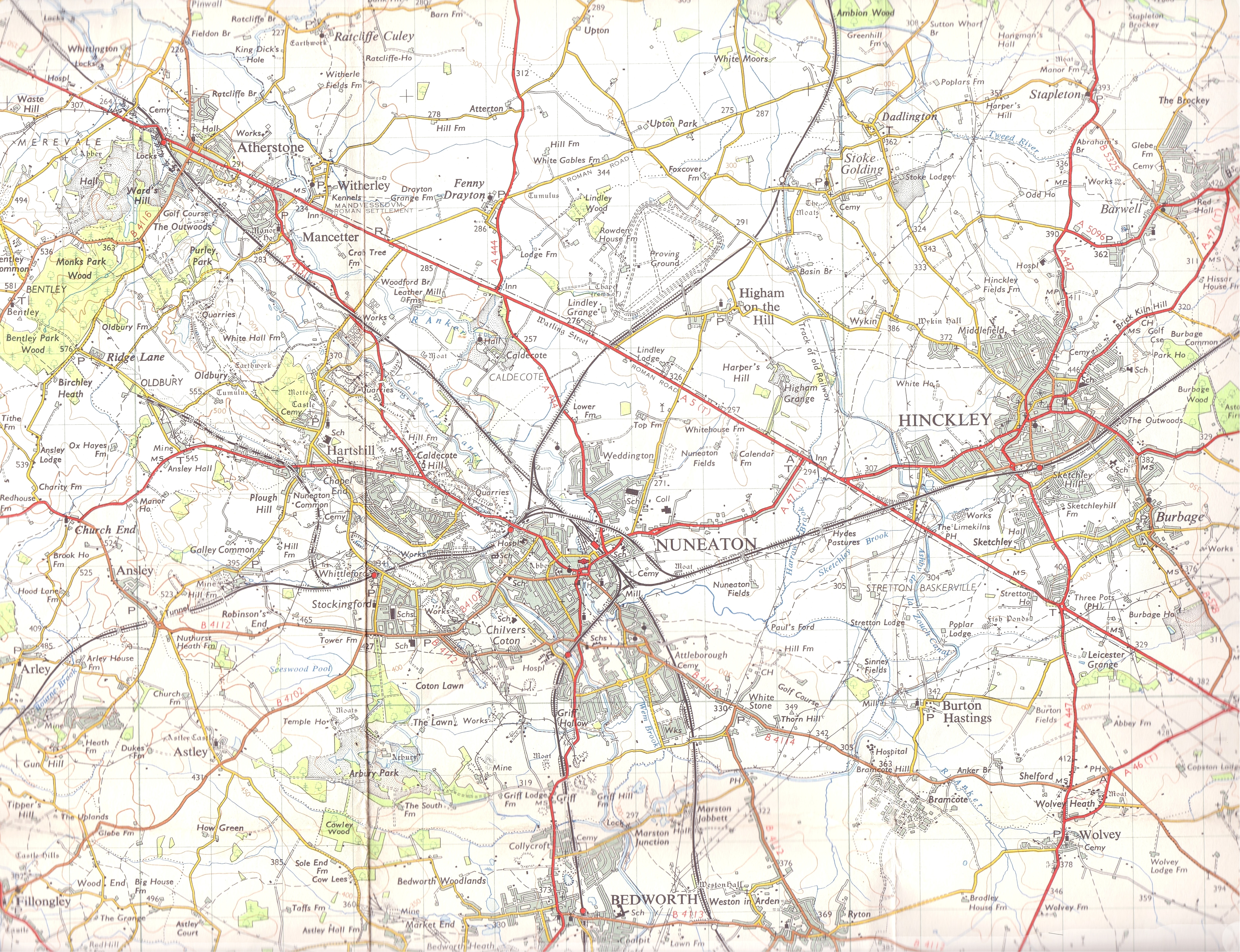
Nueaton Hinkley 1961 OS.jpg - Wipsenade

The natural shape of England with the names of rivers, seaports, sands, hills, moors, forrests, and many other remarks which the Curious will observe (8642554211).jpg - File Upload Bot (Magnus Manske)

CanuteEngland.jpg - Coeur-de-lion1
An accurate map of England and Wales with the principal roads from the best authorities. NYPL1404022.tiff - Fæ

Malria in England. Wellcome L0024499.jpg - Fæ

Detail of plate showing Porlok and Minhed Wellcome L0071620.jpg - Fæ

Map of England & Wales showing population, 1700s. Wellcome M0000912.jpg - Fæ

Sketch map of Haire de Grace Wellcome M0012867.jpg - Fæ

A history of England (1916) (14760556486).jpg - Fæ

Cornelii Taciti de vita Agricolae (1922) (14774358631).jpg - Fæ
UBBasel Map 1556 Kartenslg AA 20 Britannia.tiff - Basel University Library

A short history of England's and America's literature, by Eva March Tappan (1906) (14597813417).jpg - SteinsplitterBot

A short history of England's and America's literature, by Eva March Tappan (1906) (14761331346).jpg - SteinsplitterBot

A shorter history of England and greater Britain (1920) (14759981176).jpg - Fæ

Ocean trade and shipping (1914) (14759161046).jpg - SteinsplitterBot

A classical atlas, to illustrate ancient geography - comprised in twenty-five maps, showing the various divisions of the world as known to the ancients, composed from the most authentic sources - with (14778037161).jpg - SteinsplitterBot

The encyclopdia britannica; a dictionary of arts, sciences, literature and general information (1910) (14593958778).jpg - Fæ

An introduction to geography, ancient modern, and sacred, with an outline of ancient history (1848) (14577089379).jpg - Fæ

Outing (1885) (14596143377).jpg - Fæ

Harper's school geography (1885) (14586866247).jpg - Fæ

Chambers's encyclopædia; a dictionary of universal knowledge (1868) (14799025693).jpg - Fæ

Our own islands; an elementary study in geography (1907) (14763301914).jpg - Fæ

Our own islands; an elementary study in geography (1907) (14579000749).jpg - Fæ

Our own islands; an elementary study in geography (1907) (14762390351).jpg - SteinsplitterBot

Our own islands; an elementary study in geography (1907) (14578835140).jpg - Fæ

The British nation a history - by George M. Wrong (1910) (14590137830).jpg - Fæ

The Quarterly journal of the Geological Society of London (1862) (14741453676).jpg - Fæ

Our own islands; an elementary study in geography (1907) (14579190837).jpg - Fæ

Bodleian Libraries, Wallis's picturesque round game of the produce and manufactures, of the counties of England and Wales.jpg - MartinPoulter

Walham Green and North End c.1860.jpg - Po Kadzieli

A new map of the British Isles, shewing their ancient people, cities, and towns of note, in the time of the Romans (NYPL b15114268-1630706).jpg - Fæ

A new map of Great Britain (NYPL b15369994-1630441).jpg - Fæ

Britain (NYPL b15373374-1505122).jpg - Fæ
A new and correct chart of the sea coast of ENGLAND, SCOTLAND and IRELAND (NYPL b13909432-1640559).tiff - Fæ

A new and correct chart of the sea coast of ENGLAND, SCOTLAND and IRELAND (NYPL b13909432-1640559).jpg - Fæ

The British Isles, comprehending Great Britain and Ireland; with the adjacent islands (NYPL b13919861-5207399).jpg - Fæ

A new and compendious map of England and Wales, wherein all the great, direct and cross roads are carefully inserted (NYPL b13919861-5207400).jpg - Fæ

World Factbook (1990) United Kingdom.jpg - Bob Burkhardt

SwanseaMaliphantSidingsMap.png - Ansbaradigeidfran

Great Thurlow Historical Map.png - Harvey Searle Vian-Smith

A general atlas Fleuron T221425-16.png - Fæ

Pas-caart van 't Canaal, vertoonende in 't geheel Engelandt, Schotlandt, Yrlandt, en een gedeelte van Vranckrijck , Hendrick Doncker 1658.jpg - Ursula Klaassen

26 of 'Geography of the British Isles from ten different standpoints, with twenty-one maps' (11185122373).jpg - Artix Kreiger 2

42 of 'Geography of the British Isles from ten different standpoints, with twenty-one maps' (11186042286).jpg - Artix Kreiger 2
134 of 'British Battles on Land and Sea' (11101997784).jpg - Artix Kreiger 2

163 of '(Hastings Guide. Second edition. A concise ... sketch of Hastings, Winchelsea, and Rye, etc.)' (11006646315).jpg - FlickreviewR 2

75 of 'The History of Shavington, in the County of Salop' (11210682705).jpg - Artix Kreiger 2

137 of 'Geology for Schools and Students- or, Former Worlds, their structure, condition, and inhabitants, etc' (11044826975).jpg - Artix Kreiger 2

976 of 'Gazetteer of the British Isles, statistical and topographical. Edited by J. Bartholomew. With appendices and special maps and plans' (11186659115).jpg - FlickreviewR 2

977 of 'Gazetteer of the British Isles, statistical and topographical. Edited by J. Bartholomew. With appendices and special maps and plans' (11188590193).jpg - FlickreviewR 2

20 of 'Geography of the British Isles from ten different standpoints, with twenty-one maps' (11184074593).jpg - Artix Kreiger 2

Image taken from page 10 of 'North Wales- how to see it for four guineas. (With a map.)' (11090417035).jpg - Artix Kreiger 2

Image taken from page 102 of 'The Port of Cardiff. (With map.)' (11151386383).jpg - Artix Kreiger 2

Charte der vereinigten Königreiche Grosbritanien und Ireland, nach den neuesten Berichtigungen und astronomischen Ortsbestimmungen entworfen auf der Sternwarte Seeberg, bey Gotha.jpg - Higgenhorscht

Karte von Grossbritannien und Ireland, nach Kitchin, Dorret und Jefferys.jpg - Higgenhorscht