Wikimedi'Òc
Modes d'emploi

Cet album fait partie des albums


Historic highways of America (Volume 5) - III.png - Sp1nd01
Plan of part of western front. LOC gm71002370.tif - Fæ
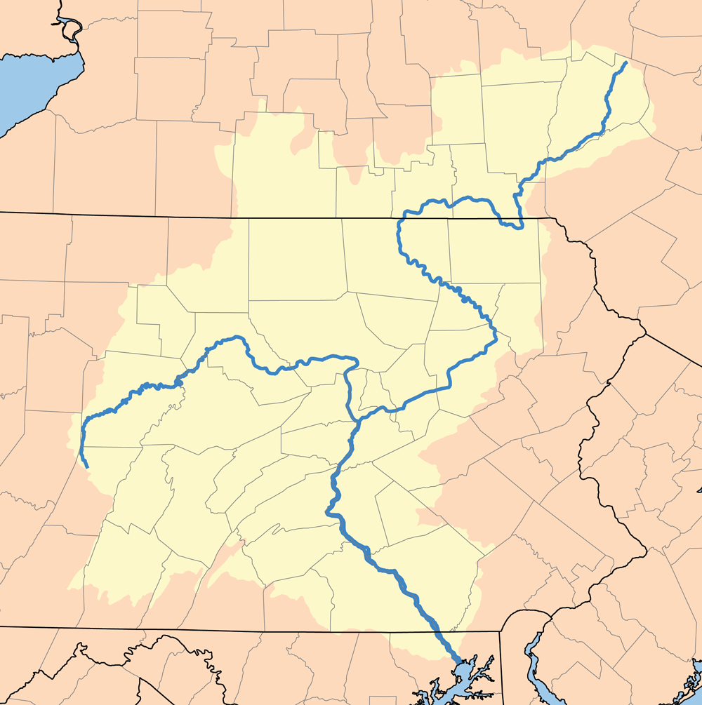
Susquehanna River watershed.png - Kmusser

Map of Colonial Maryland.jpg - Janneman
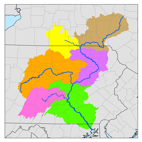
Sub-watersheds of the Susquehanna River.png - Kmusser

Susquehanna River watershed with the Chemung River watershed highligted.png - Kmusser

Susquehanna River watershed map with upper Susquehanna River watershed highlighted.png - Kmusser

Susquehanna River watershed map with middle Susquehanna River watershed highlighted.png - Kmusser

Susquehanna River watershed map with lower Susquehanna River watershed highlighted.png - Kmusser

Susquehanna River watershed map with West Branch Susquehanna River watershed highlighted.png - Kmusser

Map of the Susquehanna River watershed with Juniata River watershed highlighted.png - Kmusser

Susquehanna Boom Map.PNG - Ruhrfisch

Susquehanna Boom Map Split.PNG - Ruhrfisch

Susquehanna Boom Map Vertical.PNG - Ruhrfisch

A Map Of The State Of Pennsylvania by Reading Howell, 1792 crop1.png - Mahahahaneapneap

Wbsusquehannamap.jpg - Shannon1

Sketch showing Proposed defences of Harrisburg, Pa., and Conowingo Bridge, Md - NARA - 305787.jpg - US National Archives bot

C&PD RR map 1895.jpg - Caseyjonz

A map exhibiting a general view of the roads and inland navigation of Pennsylvania, and part of the adjacent states (5385393632).jpg - File Upload Bot (Magnus Manske)
Susquehanna River to Schuylkill River, Chesapeake Bay to Delaware Bay. NYPL484199.tiff - Fæ

The story of some French refugees and their "Azilum," 1793-1800 (1903) (14786911273).jpg - Fæ

A tour of four great rivers- the Hudson, Mohawk, Susquehanna and Delaware in l769; being the journal of Richard Smith of Burlington, New Jersey; (1906) (14596720309).jpg - Fæ

Footprints of the red men. Indian geographical names in the valley of Hudson's river, the valley of the Mohawk, and on the Delaware- their location and the probable meaning of some of them (1906) (14742177436).jpg - Fæ

1756 Lotter Map of Eastern Pennsylvania, & New Jersey cropped from Geographicus-1756.jpg - Fabartus

281 of 'Physical Geography. By W. M. Davis ... assisted by William Henry Snyder. (With plates.)' (11288822644).jpg - Artix Kreiger 2

132 of 'Eighty Years' Progress of the United States- a family record of American industry, energy and enterprise ... By eminent literary men (C. L. Flint and others) ... Embellished with ... engravings, etc' (11086527843).jpg - Artix Kreiger 2

Plan of part of western front. LOC gm71002370.jpg - Fæ
(The Part of Pennsylvania that lies between the forks of the Susquehannah, divided into townships. LOC gm71002328.tif - Fæ

1795 Schuykill Navigation company Map for PA canals.jpg - Risk Engineer

Sign for Lower Susquehanna Heritage Greenway Trail (2022).jpg - Engineerchange

Conowingo Map 1900.jpg - J Clear

Susquehanna watershed.png - Mheberger

Admiralty Chart No 2856 Chesapeake Bay Cove Point to Susquehanna River, Published 1922, Large Corrections 1964.jpg - Kognos