Wikimedi'Òc
Modes d'emploi

Cet album fait partie des albums
Cet album photos contient les sous-albums suivants :


Maratha Expansion to Bajirao c.1733.png - Rawn3012

India 1792 shepherd 1923.jpg - Yann
Moghul india.png - Kmusser
Karta marathriket 1790.jpg - Nicke L

Marathas.GIF - Electionworld

Marathe.jpg - Bilou~commonswiki

India map 1700 1792.jpg - Crashed greek

Joppen1907India1795a.jpg - Crashed greek

1800 Faden Rennell Wall Map of India - Geographicus - India-faden-1795.jpg - BotMultichillT

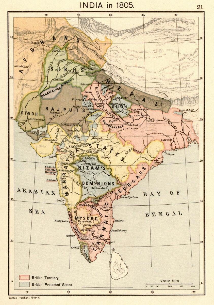
Joppen1907India1805a-21.jpg - Trotting cove

Maratha Empire 1680.PNG - Crashed greek
Maratha Empire 1674 - 1818 ad.PNG - File Upload Bot (Magnus Manske)

Principal roads and divisions of Hindoostan Rennell 1788.jpg - Shyamal

India in 1792.jpg - Shyamal

Shivájí, the Marátthá, his life and times (1915) (14779744754).jpg - SteinsplitterBot

Decaan from a map by Gilles Robert de Vaugondy, 1793 .jpg - Baddu676

Maratha Empire 1674 - 1818 ad (hy).png - O'micron
Shivaji's kingdom 1680.jpg - Nana Katya

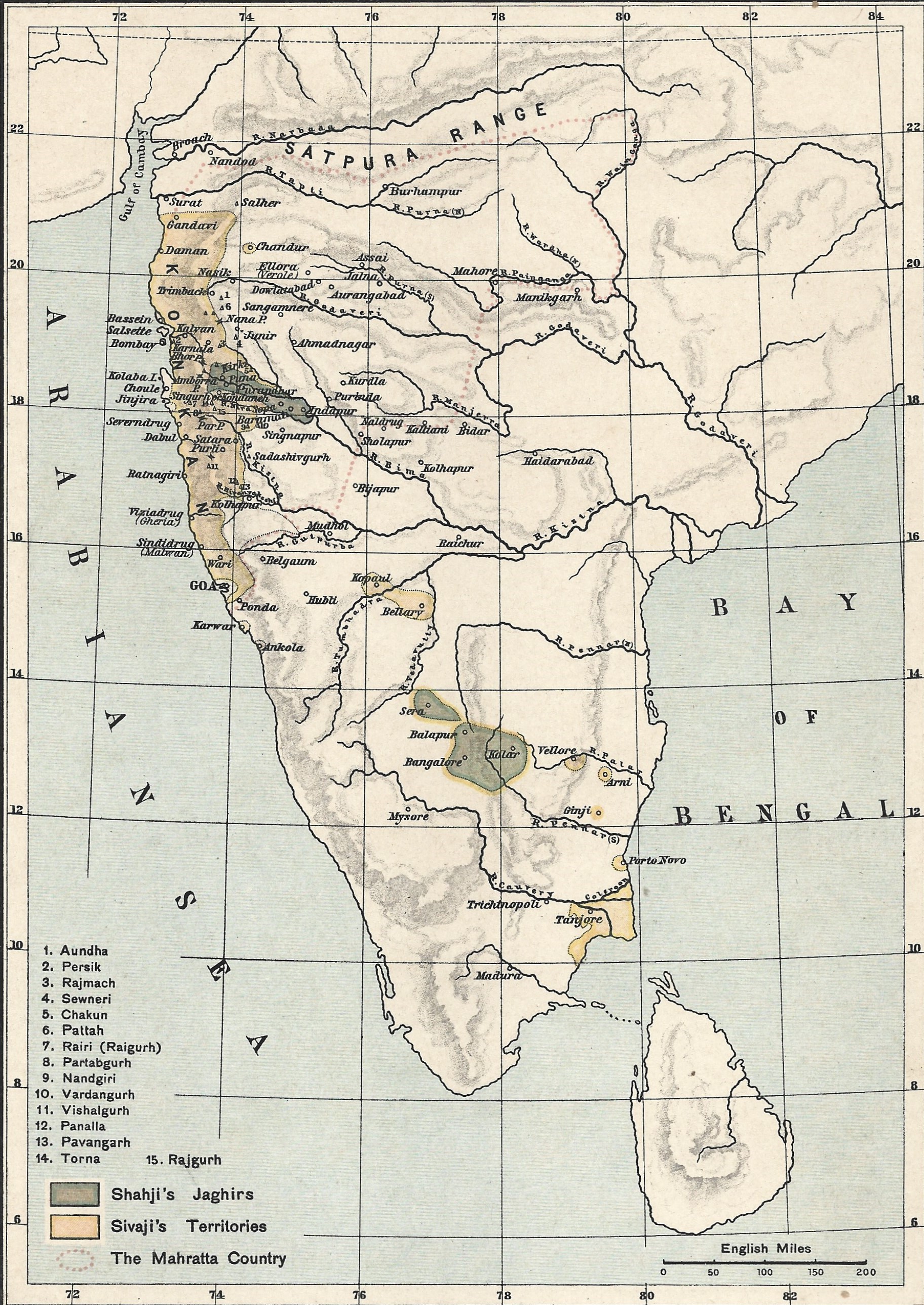
Larger map of marathas from "Historical Atlas of India," by Charles Joppen.jpg - Baddu676

400 of 'Illustrated Battles of the Nineteenth Century. (By Archibald Forbes, Major Arthur Griffiths, and others.)' (11137415455).jpg - Pratishkhedekar

7 of '(The Tanjore Mahratta Principality in Southern India- the land of the Chola; the Eden of the south.)' (11103819065).jpg - Artix Kreiger 2
Hindoostan LOC 2009582749.tif - Fæ

Hindoostan LOC 2009582749.jpg - Fæ

The East Indies with the roads LOC 2013593205.jpg - Fæ
A new general map of the East Indies - exhibiting in the Peninsula on this side of the Ganges, or Hindoostan, the several partitions of the Mogul's Empire ; and the dominions of the English East India LOC 2011589604.tif - Fæ

A new general map of the East Indies - exhibiting in the Peninsula on this side of the Ganges, or Hindoostan, the several partitions of the Mogul's Empire ; and the dominions of the English East India LOC 2011589604.jpg - Fæ

Map showing places of Shivaji's campaigns.jpg - Pratishkhedekar

Portuguese possessions in the Province of North.jpg - Pratishkhedekar
1800 Map of Peninsular India-1795.jpg - Shyamal

Map to illustrate Shahu's war against the Siddis of Janjira 1733-36.jpg - Pratishkhedekar

Shivaji's Kingdom 1680.jpg - Pratishkhedekar

Battle of Moti Talao 8 Mar 1773.jpg - Pratishkhedekar

Retreat of Col Monson 1804.jpg - Pratishkhedekar

Battle of Pattankudi, 17 Sep 1799.jpg - Pratishkhedekar

Wellesleys campaign against Dhondji Wagh 1800.jpg - Pratishkhedekar

Palkhed Campaign of Marathas under Bajirao.jpg - Pratishkhedekar

Shivaji's retreat from Panhala to Vishalgad.jpg - Pratishkhedekar

Battle of Sakhar Kherda 13 Oct 1724.jpg - Pratishkhedekar

Marathe-es.svg - Rowanwindwhistler

India 1760-es.svg - Rowanwindwhistler

Joppen1907India1805a-21-es.svg - Rowanwindwhistler

Kaart van Zuid-Azië 1 Partie de la nouvelle grande carte des Indes Orientales contenant les terres du Mogol, Surate, Malabar, Cormandel, Bengale, Aracan, Pegu, Siam, Camboje, Tonquin & une partie de la Chine dressée ave, NG-501-66.jpg - Mr.Nostalgic
Maratha Empire in 1758.png - Fidolex

A Map of the Country Inhabited by the Marattas, with the Dominions of Angria (BM 1875,0109.109).jpg - Copyfraud
Joppen1907India1805a.jpg - Beao

Maratha Expansion under Shahu and Bajirao.jpg - Pratishkhedekar

1781 - 1800 - 04 1800 Route of Col Wellesley along boundary dividing Marratta Territories from Soonda by Colebrooke.jpg - Shyamal

Mahratta Country.jpg - Pratishkhedekar

Hindustan, 1803.jpg - Pratishkhedekar

The Seat of the Mahratta War.jpg - Pratishkhedekar

Joppenshivaji.jpg - Ratnahastin

A map of Hindoostan, or the Mogul Empire, 1788.jpg - Pratishkhedekar

Marathas.JPG - Vastu

Battle of Shakar Khera.jpg - Pratishkhedekar

ہندوستان1760.png - Abbas dhothar

Southern India in 1680.png - Fayninja

India in 1785.png - Fayninja

India in 1798.png - Fayninja

India in 1805.png - Fayninja
Early Maratha History-Joppen.jpg - Fowler&fowler

Map of the Maratha Empire 1760.svg - Ayunipear

Map of Afzalkhan campaign.jpg - Pratishkhedekar

Shivaji's kingdom-ar.png - باسم

Shivaji's March to Jinji.jpg - Dharmaxex

More Dynasty.jpg - 99y4ij

Nagpur Bhonsle Kingdom.png - Sudsahab

Maratha Confederacy.svg - Nikel3012

Maratha Confederacy's stable boundaries.svg - Nikel3012

বাজী রাও - সখারাম গণেশ দেউস্কর p22.jpg - Hrishikes

States of the Maratha Confederacy at peak 1760.png - PadFoot2008

Detail of Sikh territory from a map of India, by James Rennell, 1 January 1788 (cropped).jpg - MaplesyrupSushi