Wikimedi'Òc
Modes d'emploi

Cet album fait partie des albums
Cet album photos contient les sous-albums suivants :


Political maps of India in the years 1765 and 1805, published in the 'Imperial Gazetteer of India' (Vol. XXVI, Atlas; 1931 revised edition; plate no. 28).jpg - MaplesyrupSushi

Maratha Expansion to Bajirao c.1733.png - Rawn3012

India 1792 shepherd 1923.jpg - Yann

India1760 1905.jpg - Abhishek0831996

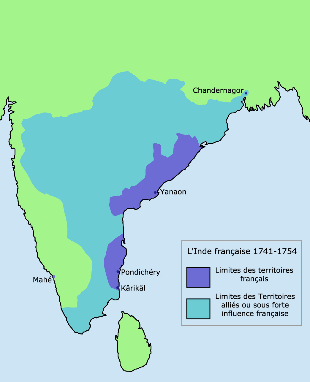
French India 1741-1754.png - Hypersite
Karta marathriket 1790.jpg - Nicke L

Indian Mysore Kingdom 1784 map.svg - Planemad

British dominion of India(1783).jpg - Lubiesque

India map 1700 1792.jpg - Crashed greek

Mysore in 1704 Joppen.jpg - Abecedare

Carte de l'Inde Française de 1741 à 1754.png - Gd21091993

India-ImperialGazetteer-1765.jpg - MALLUS

Joppen1907India1795a.jpg - Crashed greek
Inde-Francaise.jpg - Hypersite

French India 1741-1754-HE.png - Ori~

HyderAliDominions1780max.jpg - Sridhar10001

SouthIndiaBetweenCarnaticWars.jpg - OgreBot

India - Division de la peninsula vèrs 1765.png - Nicolas Eynaud

India in 1792.jpg - Shyamal

A short history of England and the British Empire (1915) (14580642538).jpg - Fæ

NORTHERN INDIA 1780 by hellbat.jpg - FastilyClone

India in 1700 from "Historical Atlas of India," by Charles Joppen.jpg - Baddu676

Map of mysore from "Historical Atlas of India," by Charles Joppen.jpg - Baddu676

99 of 'Géographie historique. Leçons en regard des cartes. Résumant l'histoire de la formation territoriale des pays civilisés et l'histoire de la civilisation, etc' (11196423004).jpg - Artix Kreiger 2

462 of 'Cassell's Illustrated Universal History' (11154470095).jpg - Artix Kreiger 2

423 of 'Britain and her Rivals in the eighteenth century, 1713-1789' (11231613176).jpg - Artix Kreiger 2

425 of 'Britain and her Rivals in the eighteenth century, 1713-1789' (11231254393).jpg - Artix Kreiger 2

Battle of Moti Talao 8 Mar 1773.jpg - Pratishkhedekar

Battle of Pattankudi, 17 Sep 1799.jpg - Pratishkhedekar

Battle of Sakhar Kherda 13 Oct 1724.jpg - Pratishkhedekar

1751 map of India from "Historical Atlas of India", by Charles Joppen.jpg - Lubiesque
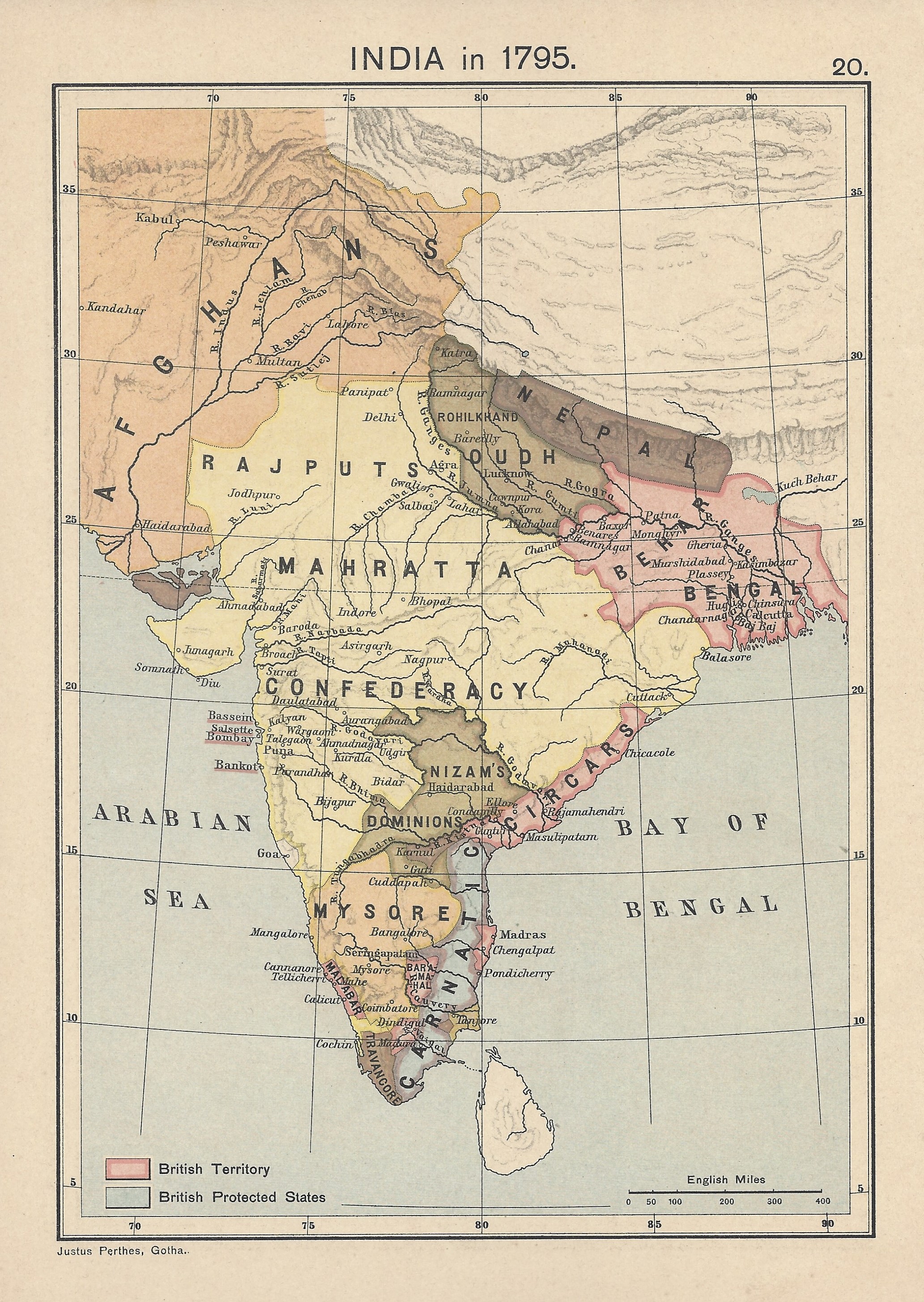
India in 1795 Joppen High Def.jpg - Fowler&fowler

India 1760-es.svg - Rowanwindwhistler

Indian Mysore Kingdom 1784 map-es.svg - Rowanwindwhistler
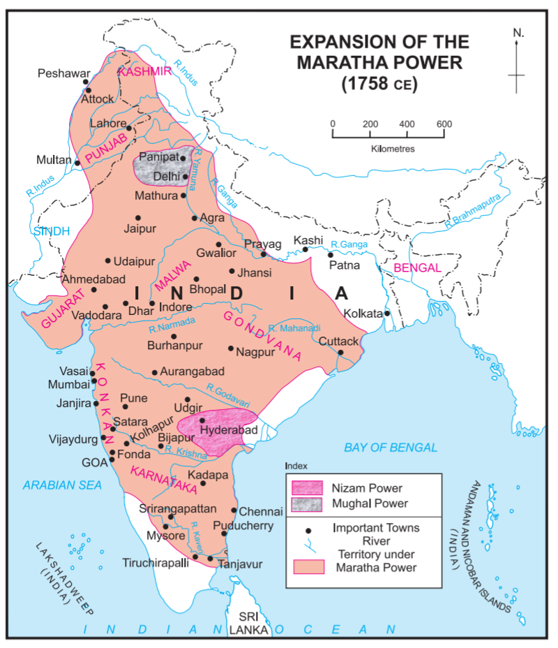
Maratha Empire in 1758.png - Fidolex

IGI1908India1765a (cropped to Bengal).jpg - Dumelow

AD 1750 MAP OF NAWABS OF BENGAL.jpg - SYED ASAD AHMED FARAZ

Historical atlas of modern Europe 1903 (135895484).jpg - Polona Upload

Battle of Shakar Khera.jpg - Pratishkhedekar
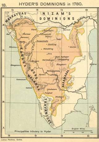
Hyder's Dominions in 1780.jpg - Mydust

ہندوستان1760.png - Abbas dhothar

The Collegiate Atlas 1876 (73060544).jpg - Polona Upload

Joppen map-India in 1751 published 1907 by Longmans.jpg - Fowler&fowler

India in 1785.png - Fayninja

India in 1798.png - Fayninja

Map of the Maratha Empire 1760.svg - Ayunipear

Map of First Sikh State.png - Shubhdeep Sandhu

Kingdom of Bharatpur under Maharaja Jawahar Singh (1767).jpg - Sonipat zamidar

Maratha Confederacy.svg - Nikel3012

Maratha Confederacy's stable boundaries.svg - Nikel3012

India-ImperialGazetteer-1765 extract for Andhra Pradesh of 2014.jpg - Arjunaraoc

C. 1700-1792 India.jpg - Ty's Commons

India in 1792 (Johnston).jpg - Enyavar

099 - Inde au XVIIIe siècle - Géographie historique. Leçons en regard des cartes.jpg - Enyavar

NWIndia 1765 imperial gazeteer.JPG - Innotata

India1765and1805b.jpg - OgreBot

Peninsular India 1792 Faden.png - Shyamal

Mughal Empire in 1700..webp - Groupsixty

India In 1751 Larger.jpg - Baddu676

India in 1795 Larger.jpg - Baddu676

Mysore wars.jpg - Baddu676

Hyder Domininion in 1780.jpg - Baddu676

India in 1751.jpg - Baddu676

India in 1795.jpg - Baddu676

Th mysore wars Map.jpg - Baddu676