Wikimedi'Òc
Modes d'emploi

Cet album fait partie des albums
Cet album photos contient les sous-albums suivants :


Carte de la Manche.png - Hohum

English Channel.jpg - Hohum

Strait of Dover map.png - Hohum

AIS Manche Est.png - Jahoe

Locatie Het Kanaal.PNG - Michiel1972

Cotid mancheSodi.svg - AnonMoos
Mareas5.png - LP~commonswiki

Beachy Head 10 July 1690.PNG - OgreBot
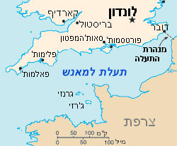
איי תעלת למנש.jpg - רוליג

Iroise sea map-en.svg - Magicpiano

Engelska kanalen svatlas.jpg - LA2

Ärmelkanal.png - Tschubby
Cowesdinard.png - Bens799

English Channel location map.svg - NordNordWest

Condor ferries route map.svg - Joe200576

Operationsgebiet der Seehunde.jpg - PimboliDD

Celtic Sea and Bay of Biscay bathymetric map-fr.svg - Sting

Map of the English Channel, Durlston Head - geograph.org.uk - 1417759.jpg - GeographBot

Bay of Biscay map.svg - VanishedUser sdu9aya9fasdsopa

Bay of Biscay map hr.svg - MaGa

Strait of Dover map hr.svg - MaGa
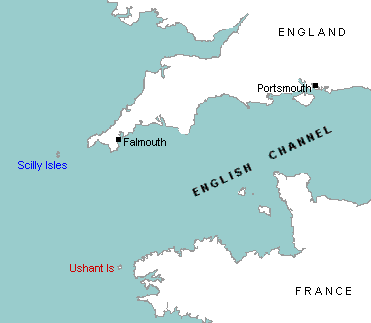
ScillyUshant.png - File Upload Bot (Magnus Manske)

ScillyUshant-he.png - החבלן

English Channel location map-he.svg - החבלן

Strait of Dover map mk.svg - Bjankuloski06en

English Channel He.jpg - Amirki

Relief Map of English Channel.png - Nzeemin

Solent map (OS).jpg - Hogweard

Ärmelkanal without Text.png - Tschubby
Ärmelkanal blank.png - Tschubby
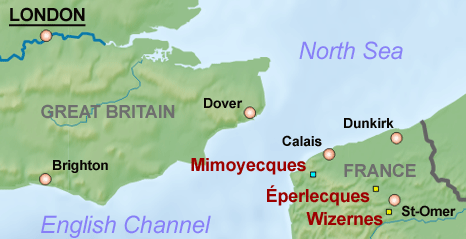
Mimoyecques-Eperlecques-Wizernes map.png - Prioryman

English Channel location map - Halsewell.svg - Aymatth2

Maritime boundaries between UK and France in Europe-fr.svg - Sémhur

Dunkirk Evacuation shipping routes.png - Hohum

Operationsgebiet der Seehund-U-Boote.png - Chumwa

Celtic Sea and Bay of Biscay bathymetric map-en.svg - Sting

HalleyEclipse1715Path.jpg - EkkehardDomning
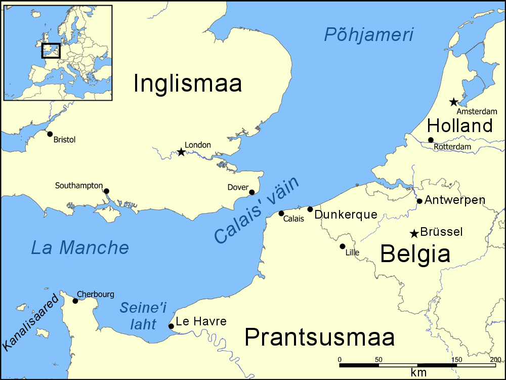
Calais' väin.png - Pikne
Boulogne Comte 1150.png - Чаховіч Уладзіслаў

Admiralty Chart No 2649 English Channel Western Portion Published 1955.jpg - Kognos
Beechey Tide Chart of the English, Irish and Bristol Channels Outgoing dated 1848.tif - Kognos
Beechey Tide Chart of the English, Irish and Bristol Channels Ingoing dated 1848.tif - Kognos
Beechey 1851 Tidal Chart of the North Sea and English Channel 3h before high water at Dover.tif - Kognos
Beechey 1851 Tidal Chart of the North Sea and English Channel 5h before high water at Dover.tif - Kognos
Beechey 1851 Tidal Chart of the North Sea and English Channel 1h before high water at Dover.tif - Kognos
Beechey 1851 Tidal Chart of the North Sea and English Channel 6h after high water at Dover.tif - Kognos
Beechey 1851 Tidal Chart of the North Sea and English Channel 3h after high water at Dover.tif - Kognos
Beechey 1851 Tidal Chart of the North Sea and English Channel 1h after high water at Dover.tif - Kognos
Beechey 1851 Tidal Chart of the North Sea and English Channel 2h after high water at Dover.tif - Kognos

117 of 'Sailing Directions for the English Channel. Part I. The South coast of England ... Part II. The North coast of France' (11187751176).jpg - Artix Kreiger 2

ISS054-E-53958 (Strait of Dover).jpg - Matthiasb

Admiralty Chart No 2675c English Channel Eastern Part, Published 1885.jpg - Kognos

1710 Samuel Thornton. A new and correct large draught of the Channell between England and France with the coast of Ireland St. Georges & Bristoll Channell and several of the most noteable harbours at large (detalle).jpg - Orestes 71

Triangulation radiogoniométrie 410 kHz.png - F1jmm

Principaux secteurs de la manche.svg - Salsero35

BRITAIN INTO EUROPE 1.jpg - Mwoolliams

Channel Islands location.svg - Hogweard

Map of the English Channel and coasts.png - Fortuna imperatrix mundi

Bay of Biscay map bs.svg - Srđan

English Channel in its region.svg - Aplaice

Itsaso Zeltikoko eta Bizkaiko Golkoko mapa batimetrikoa.svg - Theklan

EB1922 - Minesweeping And Minelaying Fig 3.png - Sp1nd01

תעלת למאנש.svg - Eitan

Admiralty Chart No 1598 English Channel and Western Approaches, Published 1961.jpg - Kognos

Admiralty Chart No 536 Beachy Head to Dungeness, Published 1967.jpg - Kognos

Map of French Flemish.jpg - Arvanhar

Batimetriezh ar Mor Keltiek ha Pleg-mor Gwaskogn.svg - Adriendelucca

Admiralty Chart No 1895 Dover Strait, Published 1959.jpg - Kognos

Celtic Sea and Bay of Biscay bathymetric map-es.svg - Tony Rotondas

Kanaalzwemmen, SFA022004955.jpg - Mr.Nostalgic

Maritime boundaries between Channel Islands and France-fr.svg - Sémhur

Harzoù etre ar rouantelezh-unanet ha frañs war vor.svg - Adriendelucca

Admiralty Chart No 1821 Asnelles to Villers including Rade de Caen, Published 1893, Large Corrections 1955.jpg - Kognos

Celtic Sea and Bay of Biscay bathymetric map-fr (cropped).svg - Ellicrum