Wikimedi'Òc
Modes d'emploi

Cet album fait partie des albums


Island of California.jpg - Foobaz
Colorado watershed.png - Kmusser

Timpanogos Valley BHoU-p13.png - Moverton
Wpdms nasa topo outline virgin river.jpg - Eldred
Karte colorado river topografisch.jpg - Maksim
Wpdms nasa topo gila river.jpg - Habj
Wpdms nasa topo gunnison river.jpg - Matthiasb
Greenutrivermap.png - Kmusser

Sevierrivermap.png - Kmusser

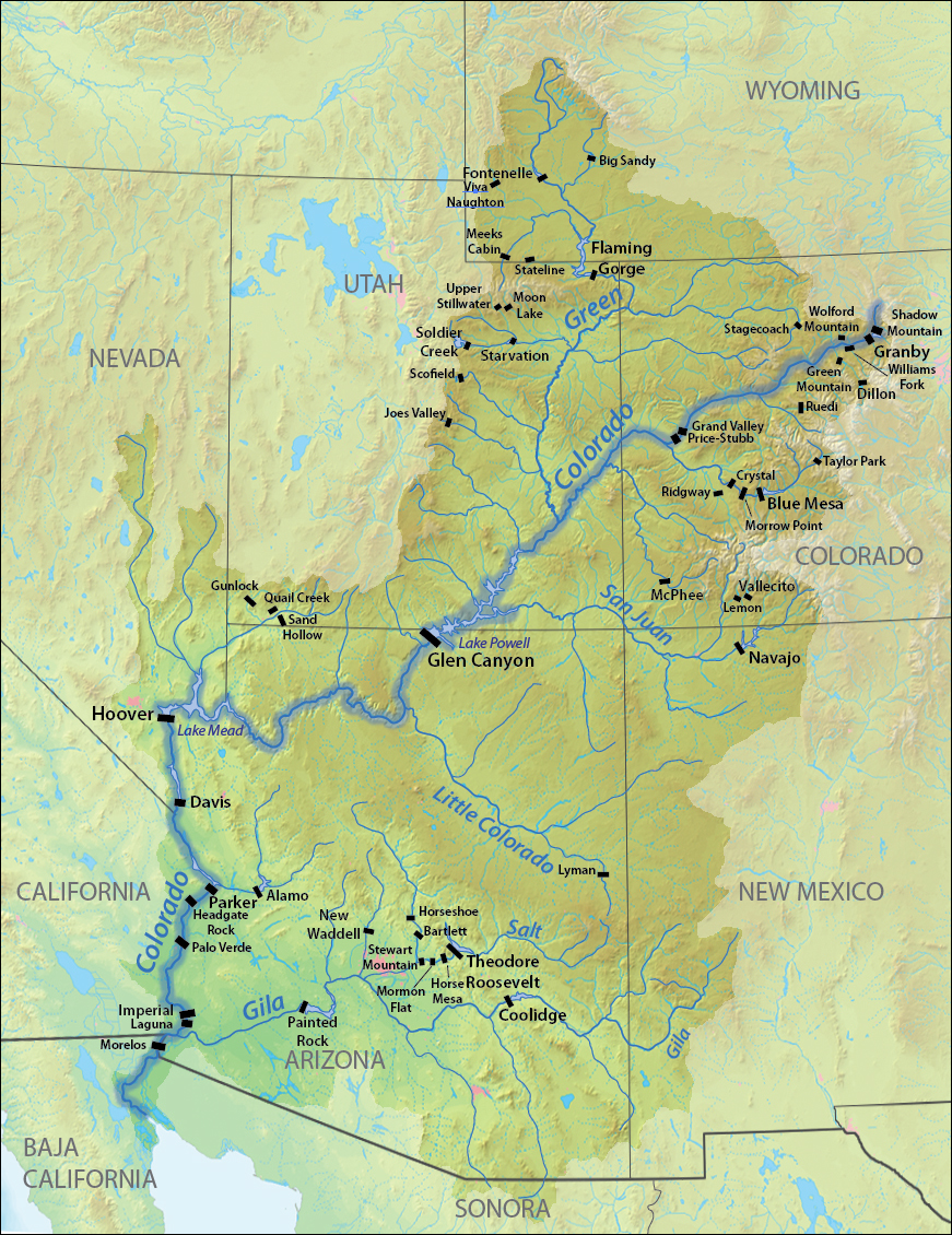
Coloradorivermap.jpg - Shannon1

Coloradorivermapnew1.jpg - Moogsi

SoCal Watershed.jpg - Shannon1

Alamo Canal 1908.png - Weedwhacker128

The Colorado River Indian Reservation in Relation to Arizona, California and Associated Counties.jpg - Cenglish

PSM V72 D480 Delta of the colorado river with salton and pattie basins.png - Ineuw
Colorado river dams.jpg - Shannon1

Map of the Colorado River, "Plan of the Rio Colorado", prepared by Lieutenant R.W.H. Hardy, R.N., "sculpted" by Sidney Hall, and published by Henry Colburn, London, August 1829 (CHS-3819).jpg - Fæ

MÖLLHAUSEN(1861) 1.472 Kartenskizzen zur Abgrenzung der Indianerstämme entlang des Flusslaufes des Colorado River.jpg - Metilsteiner

Bulletin of the United States Geological Survey-Pre-Cambrian Geology of North America (1908) (14771699195).jpg - Fæ

Bulletin of the United States Geological Survey-Pre-Cambrian Geology of North America (1908) (14585059368).jpg - Fæ

Bulletin of the United States Geological Survey-Pre-Cambrian Geology of North America (1908) (14769343234).jpg - Fæ

California fish and game (20325066528).jpg - Fæ

Bancroft's Works History of the Northwest Coast vol 1 (1884) (14764307522).jpg - Fæ

Report upon the Colorado River of the West BHL32741071.jpg - Fæ

Report upon the Colorado River of the West BHL32741072.jpg - Fæ

Report upon the Colorado River of the West BHL32741080.jpg - Fæ

Report upon the Colorado River of the West BHL32741081.jpg - Fæ

Littlecoloradomap.png - Shannon1

PacSo Grand Canyon Dams-01.png - Shannon1
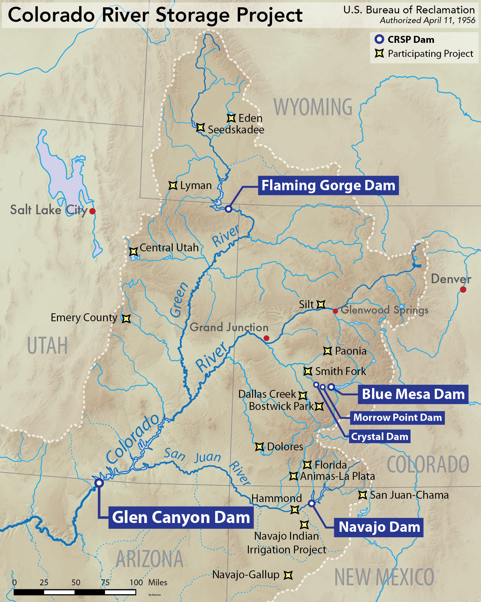
Colorado River Storage Project map.png - Shannon1

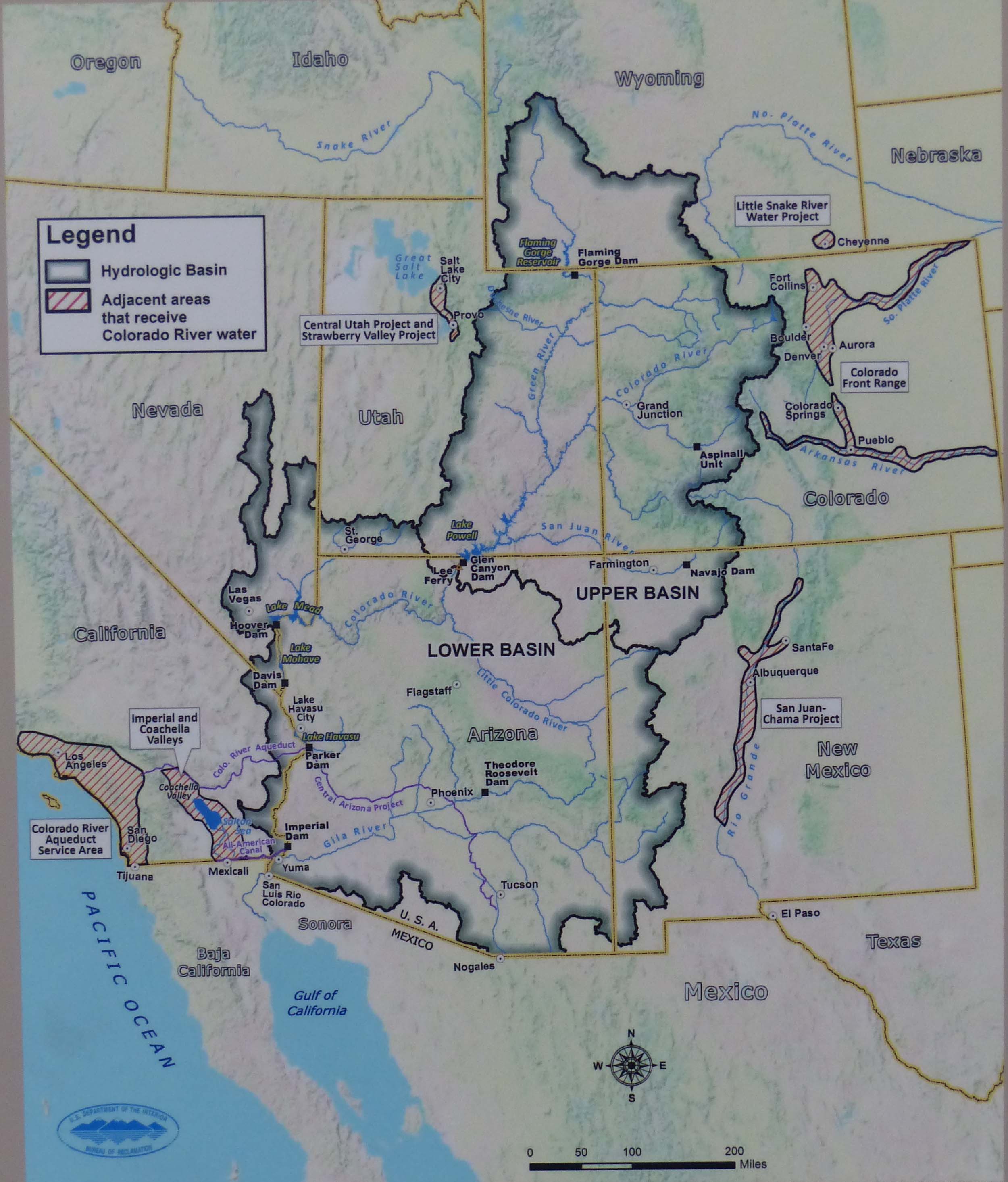
Colorado River basin map.png - Shannon1
Colorado Watershed Map.jpg - Kognos
Colorado River Basin - NARA - 6050554 (page 2).pdf - US National Archives bot

Admiralty Chart No 2324 Cape St Lucas to San Diego Bay with the Gulf of California, Published 1879.jpg - Kognos

Admiralty Chart No 2324 Cape San Lucas to San Diego Bay with the Gulf of California Chiefly from the Surveys of Commander G. Dewey & Officers of the United States Ship Narrangansett 1873-5 with corrections to 1895, Published 1879.jpg - Balkanique

CRBS Executive Summary FINAL-01.png - Shannon1

Coloradorivermap (Utah detail).jpg - Thesavagenorwegian