Wikimedi'Òc
Modes d'emploi

Cet album fait partie des albums
Cet album photos contient les sous-albums suivants :


1970 constituencies - Northern Ireland.png - TyronePoliHist

1982 constituencies - Northern Ireland.png - TyronePoliHist

1995 Northern Ireland constituencies labelled.png - TyronePoliHist

1920 Northern Ireland constituencies.png - TyronePoliHist

1948 constituencies Northern Ireland.png - TyronePoliHist

Northern Ireland parliamentary constituencies 2008 labelled.png - TyronePoliHist

Northern Ireland 2012 electoral wards map.png - TyronePoliHist

Densest contiguous wards Northern Ireland - in purple.png - TyronePoliHist

Religion by DEA in Northern Ireland in 2001.png - Ndnilp

Religion by DEA in Northern Ireland in 2021.png - Ndnilp

Religion by DEA in Northern Ireland in 2011.png - Ndnilp

Densest contiguous wards Northern Ireland.png - TyronePoliHist

Other languages.png - Ndnilp

2021 differences in National Identity.png - Ndnilp

Born outside NI.png - Ndnilp

Contiguous majority wards - around Belfast (with motorways dcs etc overlaid).png - TyronePoliHist

Densest contiguous wards with motorways railways etc.png - TyronePoliHist

NorthernIreland2025OSM.png - Kelisi

Ordnance Survey Six-Inch Grid of Sheets for Northern Ireland.png - AFBorchert
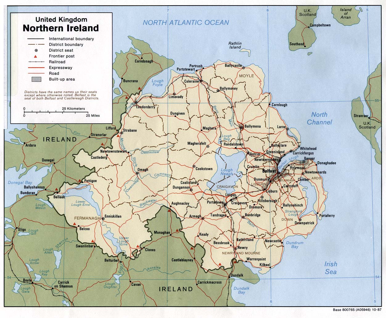
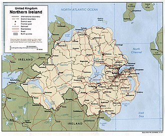
NImap-CIA.jpg - Hoshie
Ni smaller.png - Bastique

Deaths in The Troubles by area.png - Ideru~commonswiki

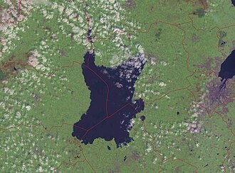
Lough-Neagh.PNG - Robert Weemeyer

Ards Peninsula.png - Renamed user OCfxJKu7j2
TheNorthOfIrelandCoalisland.png - Astur1

Northern Ireland map - April 2007.png - Pit-yacker
Northern Ireland 1899 non-administrative counties flood damage 24 July 2007.png - Anameofmyveryown

Northern Ireland districts flood damage 24 July 2007.png - Anameofmyveryown
Irlande-du-nord-religions-1.png - Christophe cagé

Northern-irland-religions-1991.jpg - Christophe cagé

Northern Ireland map - July 2007.png - Asarlaí
NorthernIrelandCouncils-religion2008.png - Setanta747~commonswiki

Irlande du nord - recensement de 2001 - carte.png - Christophe cagé

Northern Ireland map grey.png - Hanhil

Lough Neagh with administrative boundaries.jpg - Chumwa

NIShape.png - Чръный человек

Broighter Gold Boat bits Vol. 32, No. 3 (Sep. 30, 1902), pp. 211-224.png - Victuallers

Gaeilig in Uladh.jpg - Ronhjones

History of Scots in Scotland and Ulster.png - Hayden120

Mormeal.png - Mabuska
Relief Map of Northern Ireland.png - Nzeemin

Northern Ireland constituencies by majority community background.jpg - Wallpaper68

Demographics of Northern Ireland - Catholic Community 2001.png - DrKay

Districts of Northern Ireland by percentage Catholic 2011.png - DrKay

Districts of Northern Ireland by Catholic percentage 2011.png - DrKay

Districts of Northern Ireland by strength of religious majority 2011.png - DrKay

Catholics in Northern Ireland 2011.png - DrKay

Protestants in Northern Ireland 2011.png - Cmdrjameson

Repartition of Ireland.png - Spesh531

LoughFoyleCloseup.png - File Upload Bot (Magnus Manske)

LoughNeaghandenvirons.png - File Upload Bot (Magnus Manske)
NIShape.gif - File Upload Bot (Magnus Manske)
Northern Ireland Map.png - Rob984
PSNI Map Northern Ireland.png - Rob984

Districts of Northern Ireland by national identity 2011.png - CodTier

Born outside Northern Ireland.png - SkateTier
Districts of Northern Ireland by predominant religion.png - SkateTier

NI26.jpg - Wavehunter

NI11w.jpg - Wavehunter

Catholic Northern Ireland Census 2011.png - SkateTier

Church of Ireland Northern Ireland Census 2011.png - SkateTier
AnnduffinFHinAM.png - GifTagger

Northern Irish districts by nationality.png - Renamed user OCfxJKu7j2

Northern Irish districts by religion.png - Renamed user OCfxJKu7j2

Ireland-Capitals-ko.png - 고려

NorthernUiNeill.png - Mabuska
The Fews outline map.jpg - MacMorrow Mór

Northern Ireland Köppen.png - Redtitan

A plat of lands belonging to the Company of Grocers (27114684914).jpg - Fæ

The plot of the lands belonging to the Company of Vintners (27449185480).jpg - Fæ

Northern Ireland - Counties copy.png - Ro.jo

74781- Brexit -aren 2016ko erreferendumeko boto emaileak Ipar Irlandan.jpg - Bt infografiak

NorthernIreland1967AdminMap.png - XrysD

Border diagram 2007.JPG - Arlene the bean

Ordnance Survey Northern Ireland One-inch Third Series Map Numbering.jpg - Kognos

IMDNI.png - Thomasf2811

Ards and North Down Borough Council Election, 2019 Map.png - Ka4bi.reddit
Poster "Irish Free State & Northern Ireland" (1929) by MacDonald Gil. Original from Museum of New Zealand. Digitally enhanced by rawpixel. (50622869723).jpg - Eyes Roger

2018-01-01-00 00 2018-01-01-23 59 CORINE Land Cover Corine Land Cover (17).jpg - Sentinel user

"Christianity in Dromore" information board - geograph.org.uk - 2605185.jpg - GeographBot

Northern Ireland Education.png - NotMuchToSay
Northern Ireland Health Boards.png - NotMuchToSay
Northern Ireland outline in blue.png - PNG crusade bot

NASA Earth Observatory Newsroom map of Ireland.jpg - Raymond Palmer

Folk-Lore, vol. 109 - face p119.png - Sp1nd01

Northern Ireland counties + districts.png - Ulamm

Electrical Power Grid - Ireland.png - HighVoltage 5576

Republic of Ireland+Northern Ireland.png - Iktsokh

Religion 2021.png - Ndnilp

NI most common national identity.png - Ndnilp

Passports.png - Ndnilp

Change in Irish Identity Relative to British Identity.png - Ndnilp

Catholic Protestant low Irish British.png - Ndnilp

No Religion Northern Irish.png - Ndnilp

Protestant Irish.png - Ndnilp

National Identity 2021 census.png - Ndnilp

National Identity Northern Ireland with place names.png - Ndnilp

National Identity in Northern Ireland by Electoral Area 2021.png - Ndnilp

National Identity in Northern Ireland by Electoral Area 2011.png - Ndnilp

National Identity 2011.png - Ndnilp

NI DEA maps with RoI - labelled plus inset.png - TyronePoliHist

NI settlement map - monocolour.png - TyronePoliHist

NI settlement map with colours by county.png - TyronePoliHist

NI combinations of 2012 DEAs which match combinations of 1993 DEAs.png - TyronePoliHist

NI wards 50% of population densest wards.png - TyronePoliHist