Wikimedi'Òc
Modes d'emploi

Cet album fait partie des albums
Cet album photos contient les sous-albums suivants :


Pensylvania Nova Jersey et Nova York cum Regionibus ad Fluvium Delaware in America sitis (4232069676).jpg - File Upload Bot (Magnus Manske)

Delaware, from the best authorities (3045317185).jpg - File Upload Bot (Magnus Manske)

Delaware Bay Vinckeboons 14.jpg - Durova
Delaware Bay Vinckeboons 14 courtesy copy.jpg - Durova

Delaware Bay Vinckeboons.jpg - Durova
1866 U.S. Coast Survey Map of the Chesapeake Bay and Delaware Bay - Geographicus - ChesapeakeBay-uscs-1867.jpg - BotMultichillT

1893 U.S. Coast Survey Nautical Chart or Map of the Chesapeake Bay and Delaware Bay - Geographicus - ChesapeakeBay-uscs-1893.jpg - BotMultichillT

1851 U.S. Coast Survey Chart or Map of the Chesapeake Bay and Delaware Bay - Geographicus - ChesapeakeBay-uscs-1851.jpg - BotMultichillT

1873 U.S. Coast Survey Chart or Map of the Chesapeake Bay and Delaware Bay - Geographicus - ChesapeakeBay-uscs-1873.jpg - BotMultichillT

1873 U.S. Coast Survey Chart or Map of New Jersey and the Delaware Bay - Geographicus - NewJersey-uscs-1873.jpg - BotMultichillT

1848 U.S. Coast Survey Map of the Delaware Bay - Geographicus - DelawareBay-uscs-1848.jpg - BotMultichillT

1855 U.S. Coast Survey Nautical Chart or Map of the Chesapeake Bay - Geographicus - ChesapeakeBayHd-uscs-1855.jpg - BotMultichillT

PSM V69 D538 Capes of delaware and chesapeake.png - Ineuw

Delaware 1804.jpg - National Public Domain Archive

EB9 Delaware.jpg - Bob Burkhardt

The colonies in 1660, Virginia, Maryland, and the Dutch and Swedish settlements on the Delaware showing extent and dates of settlement (8347571652).jpg - File Upload Bot (Magnus Manske)

Carte de la Virginie, du Maryland et de letat de Delaware (4578767503).jpg - File Upload Bot (Magnus Manske)

A chart of Delaware Bay and River, containing a full and exact description of the shores, creeks, harbours, soundings, shoals, sands, and bearings of the most considerable land marks, from the capes to Philadelphia (4578700023).jpg - File Upload Bot (Magnus Manske)

A new and acccurate chart of the Bay of Chesapeak, including Delaware Bay ... (3046333690).jpg - File Upload Bot (Magnus Manske)

Delaware (3046242852).jpg - File Upload Bot (Magnus Manske)

Map of the South River in New Netherland WDL10085.png - Fæ
A new and accurate chart (from Captain Holland's surveys) of the North American Coast, for the navigation between Cape Cod in New England and the Havanna in the Gulf of Florida respectfully inscribed NYPL434115.tiff - Finavon
Baye de la Delaware avec les ports, sondes, dangers, bancs, etc - depuis les caps jusqu'à Philadelphie - d'après la carte de Joshua Fisher, publiée a Philadelphie. NYPL976370.tiff - Fæ
A chart of Delawar Bay - with soundings and nautical observations - taken by Capt. Sir Andrew Snape Hammond of the Navy and others; composed ... for the use of pilotage by J.F.W. Des Barres esqr. NYPL464966.tiff - Fæ
A chart of Delaware Bay and River - containing a full and exact description of the shores, creeks, harbours, soundings, shoals, sands, and bearings of the most considerable land marks etc etc - NYPL433943.tiff - Sebastian Wallroth
A chart of Delaware Bay and River - containing a full and exact description of the shores, creeks, harbours, soundings, shoals, sands, and bearings of the most considerable land marks etc etc - NYPL1030125.tiff - Fæ
A chart of Delaware Bay and River - from the original by Mr. Fisher of Philadelphia, 1776. NYPL465941.tiff - Fæ
A chart of Delaware Bay and River - from the original by Mr. Fisher of Philadelphia, 1776. NYPL495170.tiff - Fæ
A chart of Delaware Bay and River - containing a full and exact description of the shores, creeks, harbours, soundings, shoals, sands, and bearings of the most considerable land marks, from the capes NYPL434492.tiff - Enyavar
A chart of Delaware Bay and River - from the original by Mr. Fisher of Philadelphia, 1776. NYPL1253194.tiff - Fæ
A chart of Delaware Bay and River - containing a full and exact description of the shores, creeks, harbours, soundings, shoals, sands, and bearings of the most considerable land marks, from the capes NYPL976368.tiff - Fæ
A chart of Delaware Bay and River - containing a full and exact description of the shores, creeks, harbours, soundings, shoals, sands, and bearings of the most considerable land marks, from the capes NYPL489833.tiff - Fæ
A new and accurate chart (from Captain Holland's surveys) of the North American Coast, for the navigation between Philadelphia and Florida respectfully inscribed to His Excellency Thomas Jefferson, NYPL434114.tiff - Fæ
Delaware - drawn by F. Lucas, Jr.; engraved by G.W. Boynton. NYPL434664.tiff - Sebastian Wallroth
The bay and river of Delaware - A.M. Peasley, sc. NYPL434535.tiff - Fæ
The Bay and river of Delaware - Hooker sculpt. NYPL433662.tiff - Enyavar

AMH-8616-NA Sketch map of Godinsbay, between Cape Hinlopen and Cape May.jpg - HuskyBot

The Swedish settlements on the Delaware, their history and relation to the Indians, Dutch and English, 1638-1664, with an account of the South, the New Sweden, and the American companies, and the (14780961914).jpg - Fæ

Report of the New Jersey commissioners on the Centennial Exhibition. (1877) (14776020682).jpg - Fæ

Report of the New Jersey commissioners on the Centennial Exhibition. (1877) (14589722828).jpg - Fæ

History of Delaware county, Pennsylvania, from the discovery of the territory included within its limits to the present time, with a notice of the geology of the county, and catalogues of its (14563603820).jpg - Fæ

A chart of Delaware Bay and River - containing a full and exact description of the shores, creeks, harbours, soundings, shoals, sands, and bearings of the most considerable land marks &c. &c (NYPL b15488591-1030125).jpg - Fæ

The Bay and river of Delaware (NYPL b15337572-433662).jpg - Enyavar

A chart of Delaware Bay and River - containing a full & exact description of the shores, creeks, harbours, soundings, shoals, sands, and bearings of the most considerable land marks, from the capes to (NYPL b15314158-434492).jpg - SteinsplitterBot

A chart of Delaware Bay and River - containing a full and exact description of the shores, creeks, harbours, soundings, shoals, sands, and bearings of the most considerable land marks, from the capes (NYPL b15328048-489833).jpg - SteinsplitterBot

A chart of Delaware Bay and River - containing a full and exact description of the shores, creeks, harbours, soundings, shoals, sands, and bearings of the most considerable land marks, from the capes (NYPL b15328048-976368).jpg - SteinsplitterBot

A chart of Delaware Bay and River - containing a full and exact description of the shores, creeks, harbours, soundings, shoals, sands, and bearings of the most considerable land marks &c. &c (NYPL b15328017-433943).jpg - SteinsplitterBot

Baye de la Delaware avec les ports, sondes, dangers, bancs, &c. - depuis les caps jusqu'à Philadelphie (NYPL b15328016-976370).jpg - SteinsplitterBot

Carte de la baye et riviere de Délaware - contenant une éxacte et entiére description des rivages, criques, havres, sondes, bas-sonds, sables et les gissements des marques les plus considérables du (NYPL b14924637-434403).jpg - SteinsplitterBot

A chart of Delawar Bay - with soundings and nautical observations (NYPL b15413180-464966).jpg - Fæ

A chart of Delaware Bay and River (NYPL b14963773-495170).jpg - Fæ

A chart of Delaware Bay and River (NYPL b14963773-465941).jpg - Fæ

The bay and river of Delaware (NYPL b15307887-434535).jpg - Fæ

A New chart of Delaware Bay - wherein the New England Channel is more correctly laid down than ever before (NYPL b15314217-434536).jpg - SteinsplitterBot

Delaware, from the best authorities (NYPL b15369810-434456).jpg - Fæ

A chart of Delaware Bay and River; from the original by Mr. Fisher of Philadelphia, 1776 (NYPL b14963773-465942).jpg - SteinsplitterBot

Nova Suecia, eller the Swenska Revier (now Delaware River) in India Occidentalis (NYPL b10003109-1692895).jpg - Fæ

Map of Delaware Bay in vicinity of Cape May (8957937613).jpg - Vanished Account Byeznhpyxeuztibuo

Baye de la Delaware avec les ports, sondes, dangers, bancs, etc. depuis les caps jusqu'à Philadelphie LOC 73694804.jpg - Fæ

Caert vande Svydt Rivier in Niew Nederland. LOC 2003623407.jpg - Fæ
A chart of Delaware Bay and River, containing a full & exact description of the shores, creeks, harbours, soundings, shoals, sands, and bearings of the most considerable land marks, from the cape to LOC 73694805.tif - Fæ

Baye de la Delaware avec les ports, sondes, dangers, bancs, etc. depuis les caps jusqu'a Philadelphie d'après la carte de Joshua Fisher publie a Philadelfia, à la Havana, Chéz de Moun̂oz, rue du LOC 74691702.jpg - Fæ
A draught of Delaware Bay. LOC gm72003568.tif - Fæ
A draught of Delaware Bay. LOC gm72003568.jpg - Fæ

A chart of Delaware Bay and River - containing a full and exact description of the shores, creeks, harbours, soundings, shoals, sands, and bearings of the most considerable land marks, from the capes LOC 74692202.jpg - Fæ

A chart of Delaware Bay and River - from the original LOC 2013593289.jpg - Fæ

An invitation to Delaware LOC 78696292.jpg - Fæ

A chart of Delawar River from Bombay Hook to Ridley Creek, with soundings &c taken by Lt. Knight of the Navy. LOC 75696335.jpg - Fæ

Birds eye view of Virginia, Maryland, Delaware, and the District of Columbia the seat of war LOC lva0000031.jpg - Fæ

A map of the state of Delaware and the Eastern Shore of Maryland - with the soundings of the Bay of Delaware LOC 2018590123.jpg - Fæ
A chart of Delawar Bay, with soundings and nautical observations. LOC 77692984.jpg - Fæ
Delaware. LOC 2018590120.tif - Fæ
The North-American pilot for New England, New York, Pensilvania, Maryland, and Virginia; also, the two Carolinas, and Florida. LOC 74180307-14.tif - Fæ

The North-American pilot for New England, New York, Pensilvania, Maryland, and Virginia; also, the two Carolinas, and Florida. LOC 74180307-14.jpg - Fæ

Plano de Philadelphia. LOC 74691685.jpg - Fæ

Plano de la Bahia de la Ware y entrada de Filadelfie ... LOC 73691796.jpg - Fæ

A map of the state of Delaware and the Eastern Shore of Maryland - with the soundings of the Bay of Delaware LOC 2018590124.jpg - Fæ

Admiralty Chart No 2563 Delaware River, Published 1858.jpg - Kognos

Admiralty Chart No 266 Great Egg Harbour to Albemarle Sound, Published 1862.jpg - Kognos

Admiralty Chart No 266 North America East Coast. Great Egg Harbor to Albemarle Sound. Including Delaware and Chesapeake Bays. Form The United States Coast Survey. 1859 - 70, Published 1862, Corrections to 1875.jpg - Balkanique

Bub gb IGk3AQAAMAAJ 0068.jpg - Gamaliel
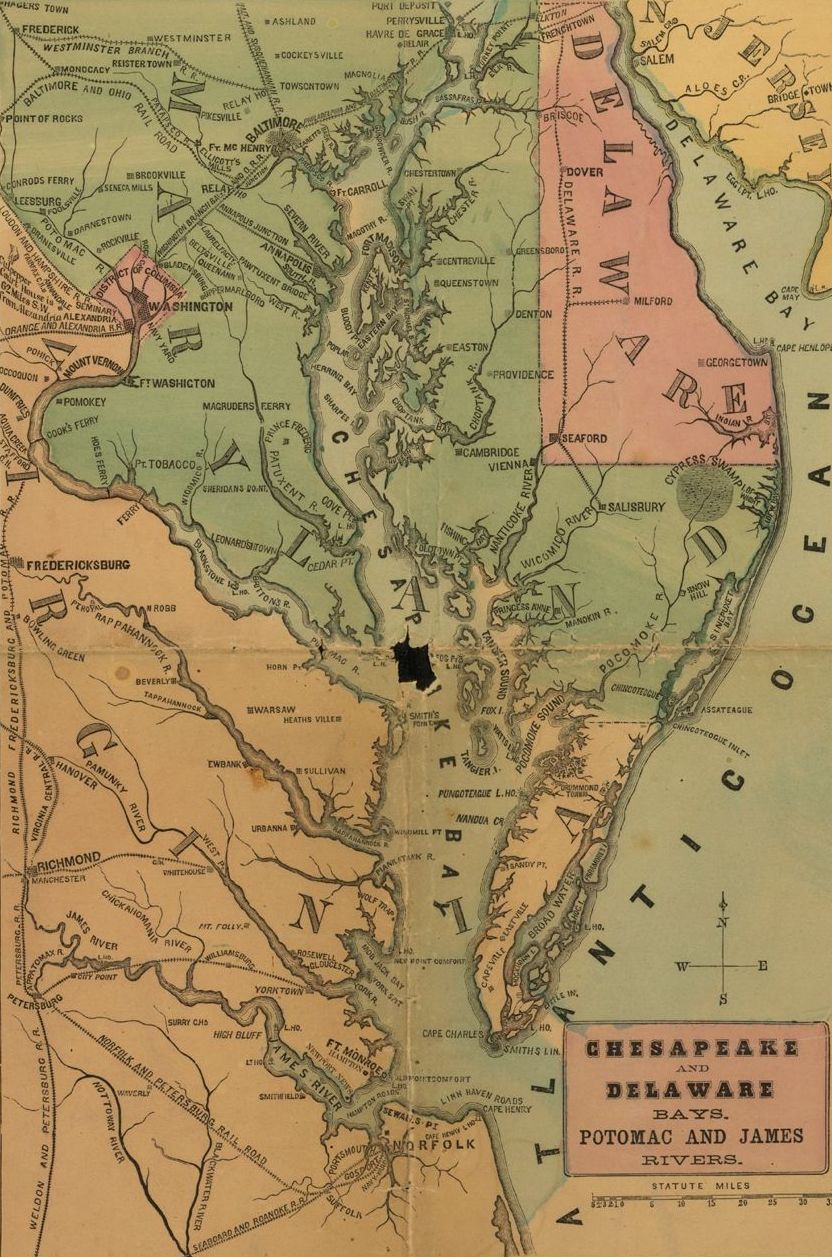
H. H. Lloyd & Co's Campaign Military Charts showing the Principal Strategic Places of Interest 1861 UTA (Chesapeake and Delaware Bays).jpg - Michael Barera

A Chart of Delaware Bay and River - J. Fisher - btv1b53089967t.jpg - Gzen92Bot

A Chart of Delaware Bay and River - J. Fisher - btv1b53089964g.jpg - Gzen92Bot

A Chart of Delaware Bay and River - J. Fisher - btv1b53089699t.jpg - Gzen92Bot

Admiralty Chart No 2563 Approaches to Delaware River, Published 1952, New Edition 1961.jpg - Kognos