Wikimedi'Òc
Modes d'emploi

Cet album fait partie des albums
Cet album photos contient les sous-albums suivants :


A short history of England (1904) (14591120918).jpg - Fæ

Analytische Plankton-Studien BHL10785925.jpg - Fæ

Analytische Plankton-Studien. Ziele, Methoden und Anfangs-Resultate der quantitativ-analytischen Planktonforschung (1892) (18143068376).jpg - Fæ

Admiralty Chart No 1 Portsmouth to Canary Islands (Islas Canarias) and the Azores (Açôres), Published 1946.jpg - Kognos
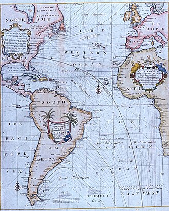
Halley compass variations 1702.jpg - Jheald

Elementary physical geography (1907) (14771615442).jpg - Fæ

Nautical chart of RMS Carpathia, 1912.04.15.png - Elekes Andor

Admiralty Chart No 367 Cape Verde to Ceara, Published 1928.jpg - Kognos

Ocean currents 1943 Gulf Stream.png - Guérin Nicolas

North Atlantic Plot April 1944.jpg - LeadSongDog

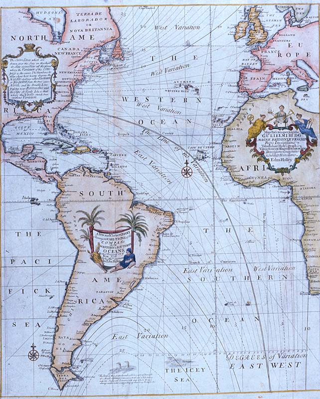
Halley compass variations 1720.jpg - Jheald

South America; a popular illustrated history of the struggle for liberty in the Andean republics and Cuba (1898) (14778542762).jpg - Fæ

Sadlier's excelsior studies in the history of the United States, for schools (1907) (14581063568).jpg - Fæ

Route der Plankton-Expedition von 1889.png - Kopiersperre

Nordatlantik hafen.jpg - Martas011

Nordatlantik.jpg - Martas011

Skálholt-Karte.png - Hopfenpflücker

Skálholt Map.jpg - Petter Strandmark

Skálholt Map (cropped).jpg - Petter Strandmark

Mapa de las tierra hiperboreas-sigurdur stefansson-1579.jpg - Enrique Cordero

Skálholt-Karte, einschließlich Legende.jpg - File Upload Bot (Magnus Manske)

Europa Atlas Blaeuw.jpg - Josef Moser

Zeekaart.png - File Upload Bot (Magnus Manske)

D481- N° 397. Océan Atlantique. - liv3-ch13.png - Vieux têtard

D493- N° 398. Plymouth et l’Atlantique. - liv3-ch14.png - Vieux têtard

D192- N° 455. Isthme entre l’Amérique et l’Afrique. - Liv3-Ch19.png - Vieux têtard

P139 - N° 548. Routes de Paris à Rio-de-Janeiro. - Liv4-Ch06.png - Vieux têtard
West-Indische paskaert - waer in de graden der breedde over weder zyden vande middellyn wassende soo vergrooten, ... Vertonende (behalven Europaes zuydlickste) alle de Zee-kusten van Africa en NYPL434667.tiff - Fæ

The botany of Iceland (1912) (20397062682).jpg - SteinsplitterBot

FMIB 37995 Weather in the North Atlantic.jpeg - BMacZeroBot

FMIB 50009 Chart of the Atlantic Ocean.jpeg - BMacZeroBot

FMIB 38410 Region included in these studies, showing localities at which collections were made.jpeg - BMacZeroBot

FMIB 43893 Northern Atlantic Ocean.jpeg - BMacZeroBot

Europa, Blaeuw.jpg - Wikidea
A map of the British and French dominions in North America - with the roads, distances, limits, and extent of the settlements, humbly inscribed to the Right Honourable the Earl of Halifax, and the (NYPL b13493675-1951054).tiff - SteinsplitterBot

St. Helena, this island belongs to ye English east India Company whose ships usually touch here for a recruit of fresh water and provisions - ; The bay of Agao de Saldanha, this bay is 70 miles north (5961367644).jpg - Fæ

Карта к статье «Колонии» № 2. Военная энциклопедия Сытина (Санкт-Петербург, 1911-1915).jpg - Schekinov Alexey Victorovich

Image taken from page 65 of '(Medeira and the Canary Islands. A ... guide for the use of invalids and tourists.)' (16404371259).jpg - Artix Kreiger 2

Image taken from page 65 of '(Medeira and the Canary Islands. A ... guide for the use of invalids and tourists.)' (11235359023).jpg - Artix Kreiger 2

Image taken from page 63 of '(Medeira and the Canary Islands. A ... guide for the use of invalids and tourists.)' (11225171934).jpg - Artix Kreiger 2

23 of 'Aperçu de l'ancienne géographie des régions arctiques de l'Amérique , selon les rapports contenus dans les Sagas du Nord' (11027553345).jpg - FlickreviewR 2
347 of 'South Atlantic Directory. The Physical Geography and Meteorology of the South Atlantic, together with Sailing Directions ... New and enlarged edition' (11245393346).jpg - Artix Kreiger 2

347 of 'South Atlantic Directory. The Physical Geography and Meteorology of the South Atlantic, together with Sailing Directions ... New and enlarged edition' (11092471206).jpg - Artix Kreiger 2

31 of 'A History of the United States of America, etc' (11245218645).jpg - Artix Kreiger 2

Carte Stefansson Torfaeus Sigrud Herjolsnes Vinland.jpg - Ruyblas13

Phantom islands in Southern Atlantic.jpg - Tangopaso

Map of Heinrich Göring's travel to Haiti.jpg - Friedolf

Carte nautique de l'Océan Atlantique, d'une partie de l'Océan Indien et d'une partie de l'Océan Pacifique - btv1b52508252t (1 of 2).jpg - Gzen92Bot

Carte nautique de l'Océan Atlantique, de la Méditerranée et d'une partie de l'Océan Pacifique - Dominguos Sanches a fes em Lisboa anno 1618 - btv1b55007072w.jpg - Gzen92Bot

Taakeheim ill 98.png - Krage52

Pascaerte van 't westelyckste deel vande Spaense Zee, tuschen Brasil, de zoute en Vlaemse eylanded, en voort westwart op. 't Amsterdam... GF 227. Pièce 15.jpg - BFT - Bibliothèque Interuniversitaire de la Sorbonne