Wikimedi'Òc
Modes d'emploi

Cet album fait partie des albums
Cet album photos contient les sous-albums suivants :


Playfair, Principal. Map of the World According to Strabo. 1814 CA.jpg - Geagea

THIRLWALL(1846) p2.028 PONTUS EUXINUS.jpg - Metilsteiner

Hartă marină Germană 1917.jpg - Spiridon Ion Cepleanu

The earth and its inhabitants (1883) (20508489613).jpg - Fæ

Brockhaus' Konversations-Lexikon (1892) (14597889919).jpg - SteinsplitterBot

Україна на карті Європи. Рис.8.png - Arxivist

Tartaria d'Europa - Tatars in Europe (1684).jpg - Giorgi Balakhadze
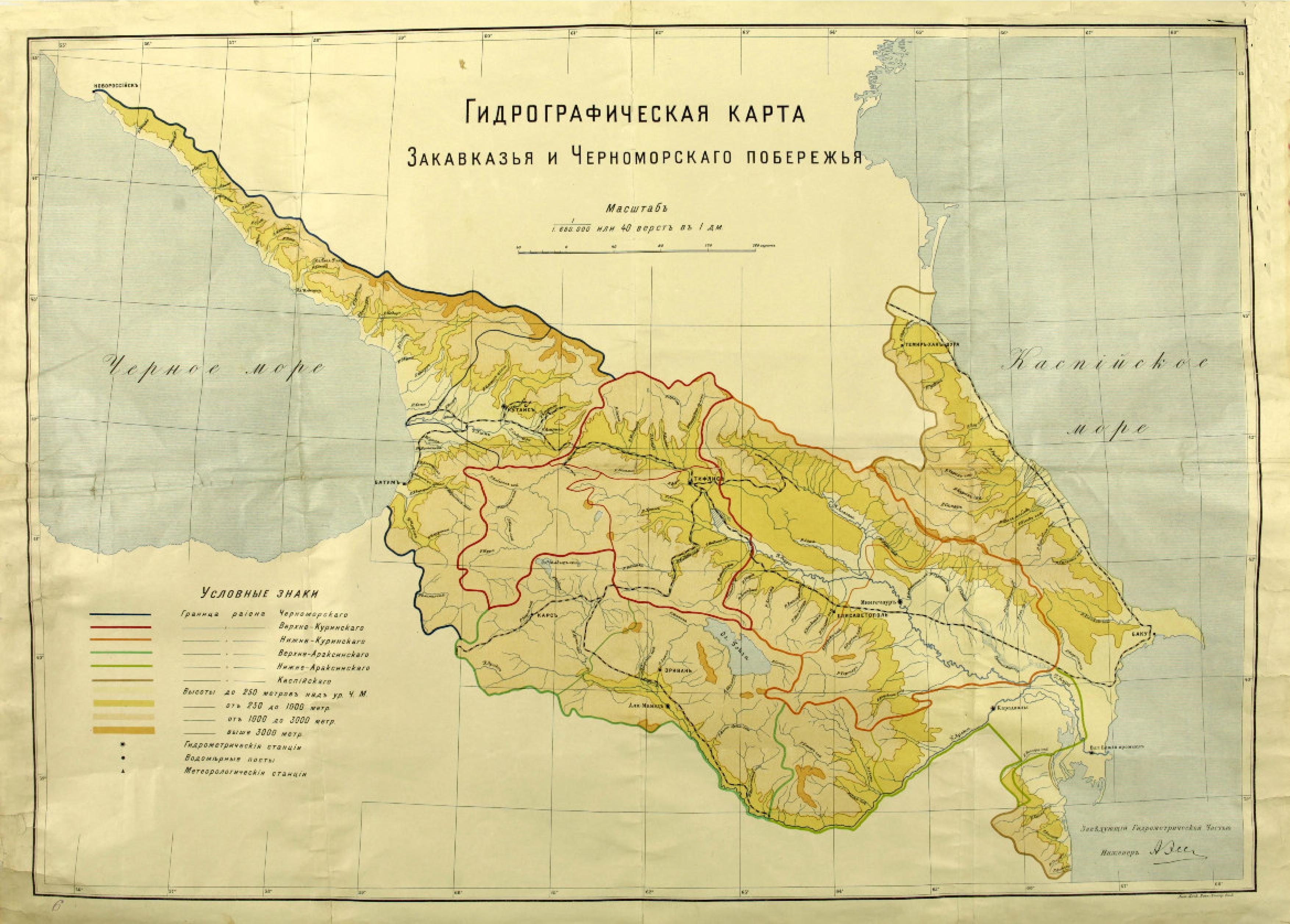
Hydrographic map of the Caucasus and the Black sea.jpg - GeoO

255 of 'Le Périple de la Mer Noire ... Traduction, étude historique et géographique, index et carte par Henry Chotard' (11060442113).jpg - Artix Kreiger 2

10 of 'Bible Lands, their modern customs and manners illustrative of Scripture' (11108067824).jpg - Artix Kreiger 2

9 of 'The Earth and its Inhabitants. The European section of the Universal Geography by E. Reclus. Edited by E. G. Ravenstein. Illustrated by ... engravings and maps' (11124603526).jpg - Artix Kreiger 2

8 of 'The Earth and its Inhabitants. The European section of the Universal Geography by E. Reclus. Edited by E. G. Ravenstein. Illustrated by ... engravings and maps' (11124833155).jpg - Artix Kreiger 2

Kianida Island or Cianeis Insula.png - Apcbg

Kaart van de landen rond de Zwarte Zee Nieuwe Kaart van de Crim, de Zwarte Zee, en Omleggende Landen (titel op object), BI-B-FM-090-102.jpg - Mr.Nostalgic

Siberia Airlines Flight 1812 I.jpg - Lonparis

P20 76 77 of 'Pomponii Melæ de situ orbis libri tres.jpg - Enyavar

P23 82 83 of 'Pomponii Melæ de situ orbis libri tres.jpg - Enyavar

Das Schwarze Meer nebst Kriegschauplatz in der europaïsch u. Asiatisch. Türkei - von F. Handtke - btv1b53102657n.jpg - Gzen92Bot

Carte du théâtre de la guerre entre les russes & les turcs - par P. Bineteau, géographe - btv1b53136116z.jpg - Gzen92Bot

Atlas nautique de l'océan Atlantique Nord-Est, de la mer Méditerranée et de la mer Noire - Gratiosus Benincasa Anchonitanus composuit Rome ano domini MCCCCLXVII - btv1b55000050r (6 of 7).jpg - Gzen92Bot

Atlas nautique de l'océan Atlantique Nord-Est, de la mer Méditerranée et de la mer Noire - Gratiosus Beninchasa Anconitanus composuit Venetijs Anno domini MCCCCLXVI - btv1b59011091 (6 of 8).jpg - Gzen92Bot

Georgia. Tartaria d'Europa - Tatars in Europe (1684) (cropped).jpg - Geagea
Black Sea (14775361427) (cropped).jpg - Geagea

Ponticum mare. Guillaume Delisle, Imperii Orientalis et Circumiacentium Regionum sub Constantino Porphyrogenito et eius praedecessoribus Descriptio (FL158893361 2749787) (cropped).jpg - Geagea

Black Sea Pilot 1969 Surface Current Circulation Page076.jpg - Kognos

Chart No 2237 Kerempe Burnu to Yasun Burnu, Published 1854, Large Corrections 1961.jpg - Kognos

Admiralty Chart No 2231 Cape Kaliakra to Odessa, Published 1854, New Edition 1919.jpg - Kognos

Admiralty Chart No 2231 Cape Kaliakra to Odessa, Published 1854, New Edition 1927.jpg - Kognos

Admiralty Chart No 2232 Odessa to Sevastopol, Published 1854, New Edition 1940.jpg - Kognos

Admiralty Chart No 603 Cape Fontana to Tendra Peninsula, Published 1887, New Edition 1920.jpg - Kognos