Wikimedi'Òc
Modes d'emploi

Cet album fait partie des albums
Cet album photos contient les sous-albums suivants :


Seattle-1911-map.jpg - Criacow
Port of Seattle map circa 1919.jpg - Jmabel

Port of Seattle map circa 1919 - enhanced.jpg - Jmabel

Seattle 1902 engineering proposals.jpg - Jmabel

Seattle's coming retail and apartment-house district - 1917.jpg - Jmabel

Kroll's Seattle 1920 plate 31W - A - raw.jpg - Jmabel

Kroll's Seattle 1920 plate 35W - A - raw.jpg - Jmabel

Seattle-1911-map-Industrial-District.jpg - Jmabel

GLO map of Interbay and Magnolia claims - 1863.jpg - Jmabel

Seattle - map - Armory Way northwest of Lenora Street 1920.jpg - Jmabel

Seattle - map - Pike Place Market and vicinity 1920.jpg - Jmabel

Seattle harbor at time of 1908 fleet visit.jpg - Jmabel

Birdseye view of Seattle 1908.jpg - Jmabel

Souvenir information guide and directory - A.Y.P. Exposition memorandum and daily calendar - Page 64-65.jpg - Dcoetzee
Seattle - North Lake Union 1911 map.jpg - Jmabel

Seattle topo map showing old route of Duwamish River.jpg - Jmabel

Seattle 1909 harbor improvements proposal on topo.jpg - Jmabel

Andersons New Guide Map of the City of Seattle and Environs, 1890.jpg - File Upload Bot (Magnus Manske)
Seattle sewer districts, 1894.jpg - File Upload Bot (Magnus Manske)
Port of Seattle map, 1918.jpg - File Upload Bot (Magnus Manske)

Bird's-eye View of Seattle, Washington Territory.jpg - File Upload Bot (Magnus Manske)

Seattle ward and precinct map, 1891.jpg - Flickr upload bot

Seattle map showing water supply pipes, 1899.jpg - Flickr upload bot

Map of Seattle Harbor, 1913.jpg - File Upload Bot (Magnus Manske)

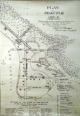
Plan of Seattle 1855-6.jpg - Pfly

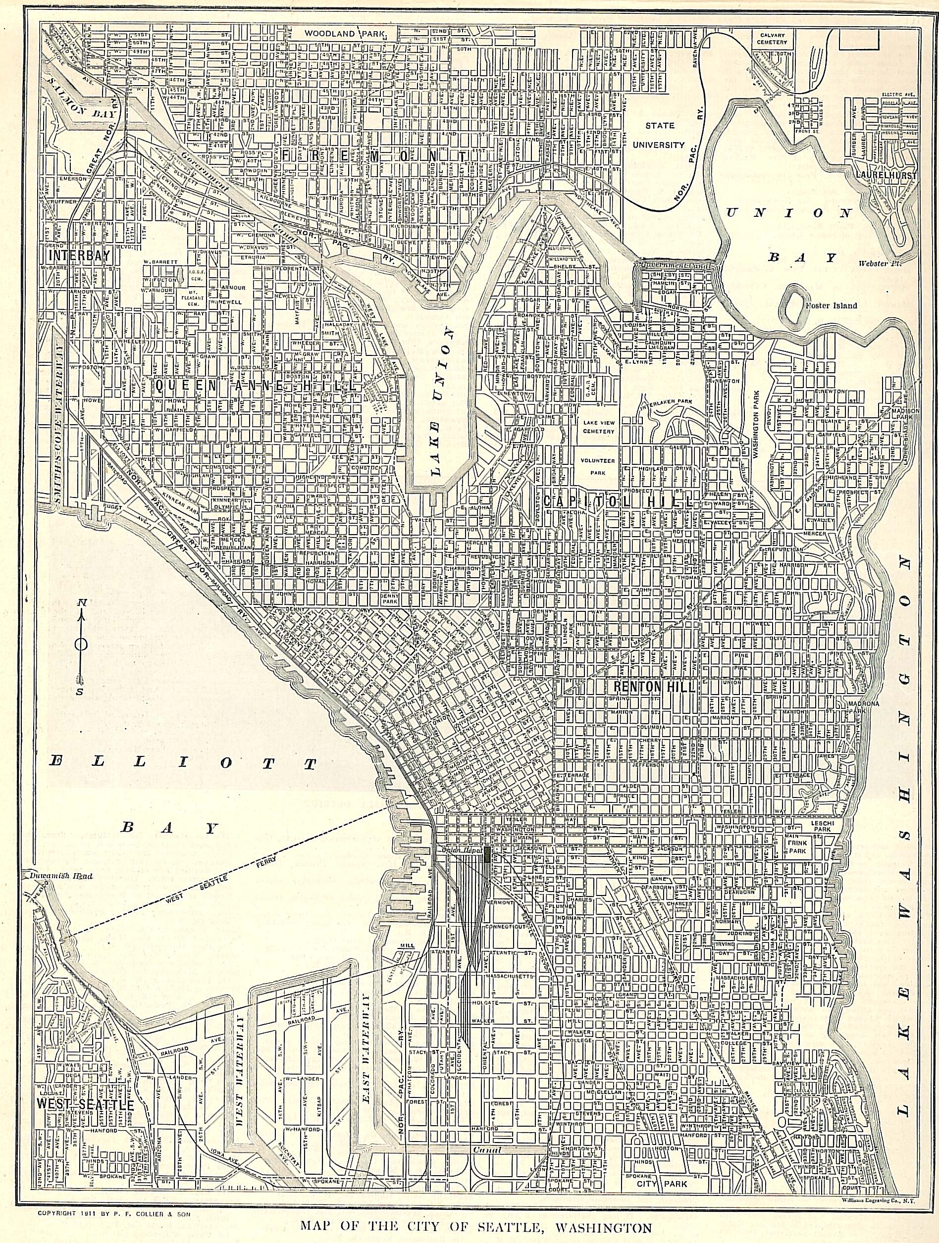
Map of Seattle 1914.jpg - Publichall

1960 map of what became Seattle Center.jpg - File Upload Bot (Magnus Manske)

Central Seattle. 1914.jpg - Jmabel
Map of Seattle in 1856.JPG - Tristan Surtel

Seattle Map 1914 (5855306176).jpg - Jmabel

Bird's Eye Map of Seattle 1889 (5276164889).jpg - Vanished user 8345627

Seattle - West Spokane Street interchanges, 1961.jpg - Jmabel

FMIB 41445 Kroll's standard map of Seattle.jpeg - BMacZeroBot

Through Colorado and Yellowstone Park to the Alaska-Yukon-Pacific Exposition, Seattle, 1909 (1909) (14572241487).jpg - Faebot

Seattle - Morningside Heights locator map, 1923.jpg - Jmabel

Section of bird's-eye map of Seattle depicting Lake Union and vicinity, Washington, 1891 (LAROCHE 330).jpeg - BMacZeroBot

Section of bird's-eye map of Seattle depicting the waterfront between Jackson St and Virginia St Washington, 1891 (LAROCHE 340).jpeg - BMacZeroBot

Pedestrian fatality map, 1944 (27629295984).jpg - Jmabel

337 of 'Atlantis Arisen; or, talks of a tourist about Oregon and Washington ... Illustrated' (11298029123).jpg - Artix Kreiger 2

Birds' eye view of Seattle and environs, King County Wash., 1891, eighteen months after the great fire - drawn by Augustus Koch. LCCN2004670275.jpg - Fæ

Foot traffic in Seattle, Washington, Wednesday, April 26th, 1922. LOC 98687155.jpg - Fæ
Anderson's new guide map of the city of Seattle and environs, Washington. LOC 98687165.tif - Fæ

Anderson's new guide map of the city of Seattle and environs, Washington. LOC 98687165.jpg - Fæ

Birds-eye-view of Seattle and environs King County, Wash., 1891. LOC 75696663.jpg - Fæ
Main business district periscopic Seattle. LOC 75696665.tif - Fæ

Main business district periscopic Seattle. LOC 75696665.jpg - Fæ

Bird's eye view of the city of Seattle, Puget Sound, Washington Territory, 1878. LOC 75696660.jpg - Fæ

Seattle birdseye view of portion of city and vicinity. LOC 75696666.jpg - Fæ

Active-survey-of-Seattle-1854.jpg - Jordanroderick

Seattle Central Waterfront 1903.jpg - Jmabel

Plan for Denny Park, Seattle, 1884 (46984533815).jpg - Jmabel

Map detail showing piers and wharves on the pre-Fire Seattle Waterfront (c. 1889).jpg - Jmabel

Anderson's 1890 map - West Seattle shore of Elliott Bay.jpg - Jmabel

Anderson's 1890 map - mudflats south of King Street.jpg - Jmabel

Anderson's 1890 map - 'North Seattle' to Smith Cove.jpg - Jmabel

Seattle - Fremont Cut and Salmon Bay map, 1918.jpg - Jmabel

Seattle map, 1904 (SEATTLE 1191).jpg - BMacZeroBot

Seattle map, 1889 (SEATTLE 150).jpg - BMacZeroBot

Seattle map, 1884 (SEATTLE 1600).jpg - BMacZeroBot

Bird's-eye view of Harbor Island and the East Waterway, Seattle, ca 1915 (SEATTLE 2136).jpg - BMacZeroBot

Plan of Seattle, 1855-6 (SEATTLE 328).jpg - BMacZeroBot

Seattle map, 1878 (SEATTLE 445).jpg - BMacZeroBot

Guide map to Seattle bicycle paths, probably 1900 (SEATTLE 5895).jpg - BMacZeroBot

Seattle map, 1891 (SEATTLE 803).jpg - BMacZeroBot

Seattle, Maps and Charts, 1841 (SEATTLE 837).jpg - BMacZeroBot

Seattle - Denny Park topographical map, circa 1893 (49070435227).jpg - Jmabel

Map of housing conditions, Seattle, 1960 (49465003892).jpg - Jmabel

Seattle - Map of The Uplands, circa 1925 (49584839983).jpg - Jmabel

Seattle - Vicinity map for proposed multi-purpose sports facility in South Lake Union, 1968 (49691418967).jpg - Jmabel

Admiralty Chart No 1427 Harbours in Puget Sound - Seattle Harbour - Tacoma Harbour, Published 1890.jpg - Balkanique

Seattle - Proposed street directional designation changes, 1960 (50195875081).jpg - Jmabel

Seattle - Yesler-Atlantic T, 1967 (50196137647).jpg - Jmabel

Seattle Sewerage Skeleton Map, July 1891 (MOHAI 13444).jpg - BMacZeroBot

Bird's-eye view of Seattle, 1908 (MOHAI 1390).jpg - BMacZeroBot

Township No 24 North Range No 4 East, 1864 (MOHAI 14539).jpg - BMacZeroBot

Ballard's Addition to Gilman Park, Seattle, March 11, 1890 (MOHAI 14540).jpg - BMacZeroBot

Map of Lake Washington Canal Entrance and Profile of Lake Washington Canal, Seattle, circa 1911 (MOHAI 14547).jpg - BMacZeroBot

Latona Addition to the City of Seattle, October 28, 1889 (MOHAI 14548).jpg - BMacZeroBot

Pettit's Historical Map of Seattle, 1913 (MOHAI 14551).jpg - BMacZeroBot

North Canal section drawings, Seattle, circa 1911 (MOHAI 14556).jpg - BMacZeroBot

Township No 25 North Range No 3 East and Township No 25 North Range No 4 East map, 1864 (MOHAI 14564).jpg - BMacZeroBot

Track System of Seattle Municipal Street Railway map, January 1920 (MOHAI 15177).jpg - BMacZeroBot

Plan of city during Battle of Seattle, 1856 (MOHAI 1791).jpg - BMacZeroBot

Map of Seattle, ca 1912 (MOHAI 1845).jpg - BMacZeroBot

Condemnation of Lane Street et al Establishing Grades map, Seattle, July 1916 (MOHAI 13392).jpg - BMacZeroBot

Plat of the Second Addition, City of Seattle, December 1876 (MOHAI 14545).jpg - BMacZeroBot

Daily pedestrian traffic map, Seattle, April 1921 (MOHAI 12716).jpg - BMacZeroBot

City of Seattle map, 1874 (MOHAI 12708).jpg - BMacZeroBot
Seattle and Environs, Eighteen Months after the Great Fire, 1891 (MOHAI 13211).jpg - BMacZeroBot

Birds Eye View of Seattle, 1889 (MOHAI 13218).jpg - BMacZeroBot

Complete Map of the City of Ballard, Wash and Vicinity, November 15, 1904 (MOHAI 13224).jpg - BMacZeroBot

Anderson Map Co's Official Map of Greater Seattle, 1909 (MOHAI 13247).jpg - BMacZeroBot

Port of Seattle General Map Seattle Harbor, May 1915 (MOHAI 13249).jpg - BMacZeroBot

Map of Harbor Island and Duwamish waterway districts, Bogue map, No 7, September 1911 (MOHAI 13254).jpg - BMacZeroBot
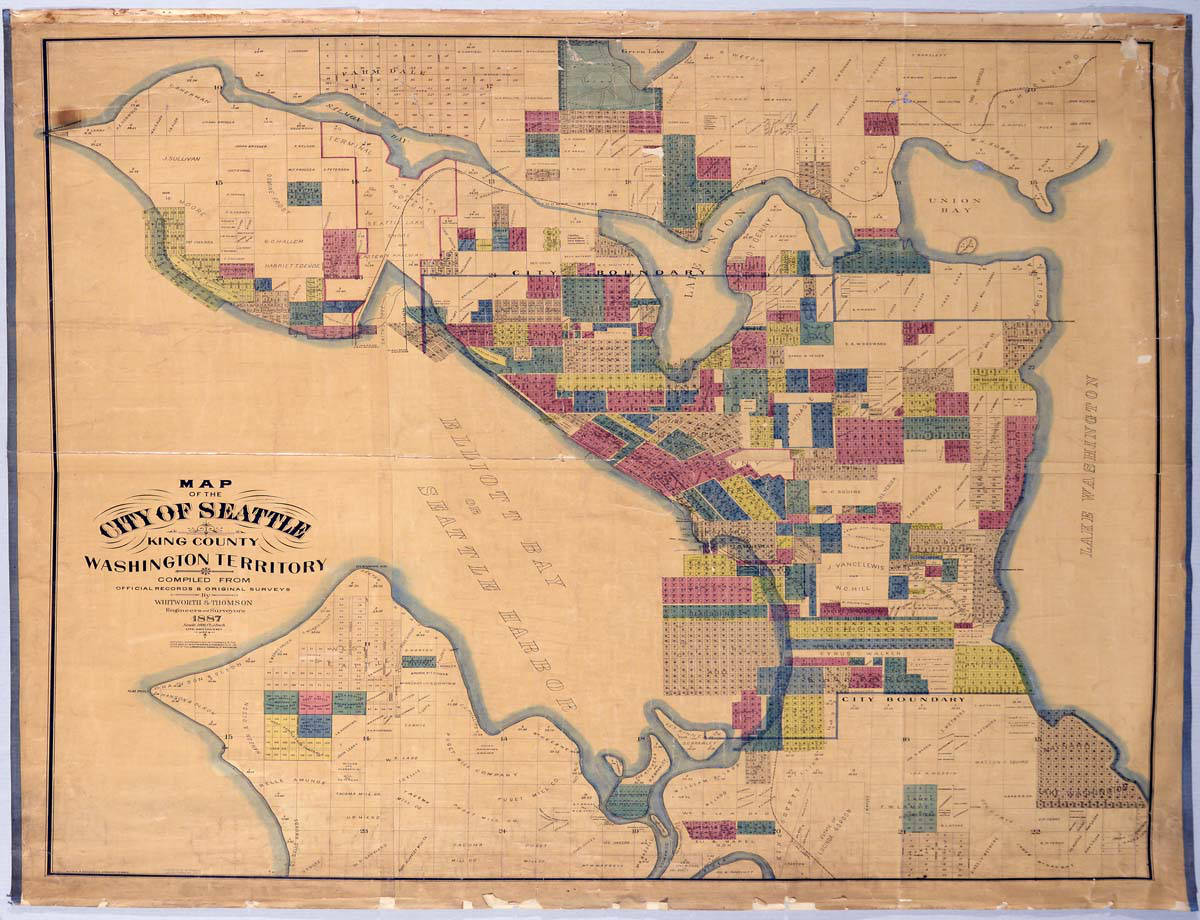
Map of the City of Seattle, King County, Washington Territory, 1887 (MOHAI 13258).jpg - BMacZeroBot

Anderson's 1896 Street and Guide Map of the City of Seattle (MOHAI 13261).jpg - BMacZeroBot

Map Showing Buildings Along Waterfront Between Marion Street & Yesler Avenue, Seattle, circa 1895 (MOHAI 13316).jpg - BMacZeroBot

Seattle Tide Lands, Volume Two, supplement to page 28, February 1, 1897 (MOHAI 13390).jpg - BMacZeroBot

James Street cable line, Seattle, 1904 (MOHAI 13395).jpg - BMacZeroBot

Proposed Plan and Improvement of Salmon Bay Harbor, Seattle, November 1892 (MOHAI 13398).jpg - BMacZeroBot

McKee's Correct Road Map of Seattle and Vicinity, 1894 (MOHAI 13401).jpg - BMacZeroBot

Anderson's New Guide Map of the City of Seattle & Environs, July 1890 (MOHAI 13402).jpg - BMacZeroBot

City of Seattle Harbor Department Map of Central Waterfront District, August 1916 (MOHAI 13403).jpg - BMacZeroBot

Boston Heights Supplemental Addition to the City of Seattle, February 25, 1890 (MOHAI 13410).jpg - BMacZeroBot

Yesler Way at Railroad Avenue map, Seattle, 1896 (MOHAI 13411).jpg - BMacZeroBot

Seattle Tide Lands, Volume Two, page 28, March 15, 1895 (MOHAI 13415).jpg - BMacZeroBot

Seattle Tide Lands, Volume Two, index, 1894-1896 (MOHAI 13416).jpg - BMacZeroBot

Supplemental Plat of Block 27 to Bell & Denny's First Add to the City of Seattle, November 4, 1887 (MOHAI 13435).jpg - BMacZeroBot

Anderson's Map of Seattle Tide Lands, circa 1907 (MOHAI 13438).jpg - BMacZeroBot

The City of Seattle Harbor Department Map of Central Waterfront District, February 1918 (MOHAI 13448).jpg - BMacZeroBot

Map of the City of Seattle and Adjacent Territory, Bogue Map No 3, 1911 (MOHAI 13267).jpg - BMacZeroBot

Map of the City of Seattle and Adjacent Territory, Bogue Map No 2, September 1911 (MOHAI 13321).jpg - BMacZeroBot
Bell's 3rd, 4th, and 5th Addition to the City of Seattle, circa 1890 (MOHAI 13330).jpg - BMacZeroBot

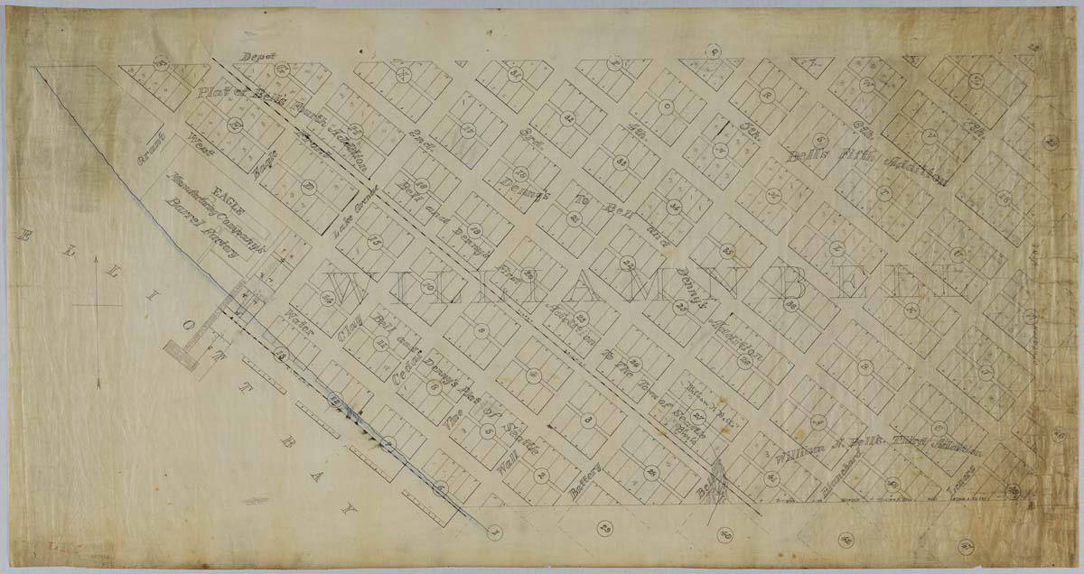
Bell's 5th Addition to the City of Seattle, March 30, 1882 (MOHAI 13331).jpg - BMacZeroBot

Christmas Ship map, 1950 (50747940467).jpg - Jmabel

Map of Seattle, 1934 (51127890592).jpg - Jmabel

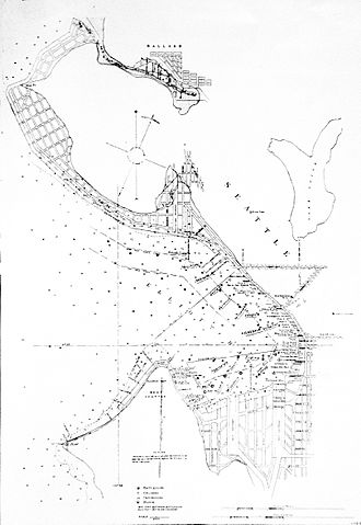
Anderson's new guide map of the city of Seattle and environs, Washington. Ballard and Salmon Bay.jpg - Krib
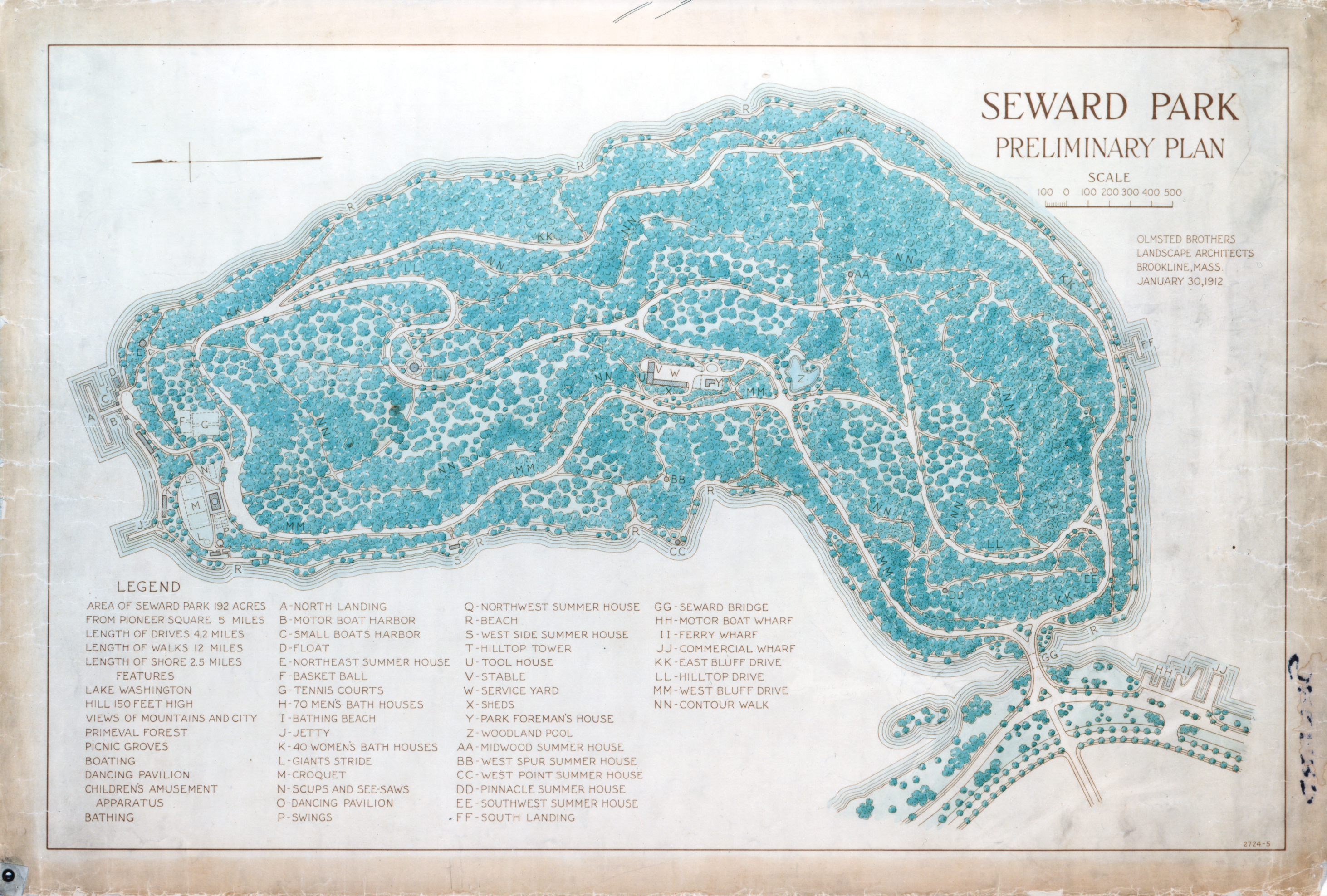
Seward Park preliminary plan, 1912 (51615389979).jpg - Jmabel

Seattle - Map of major roads, 1929 (51747999747).jpg - Jmabel

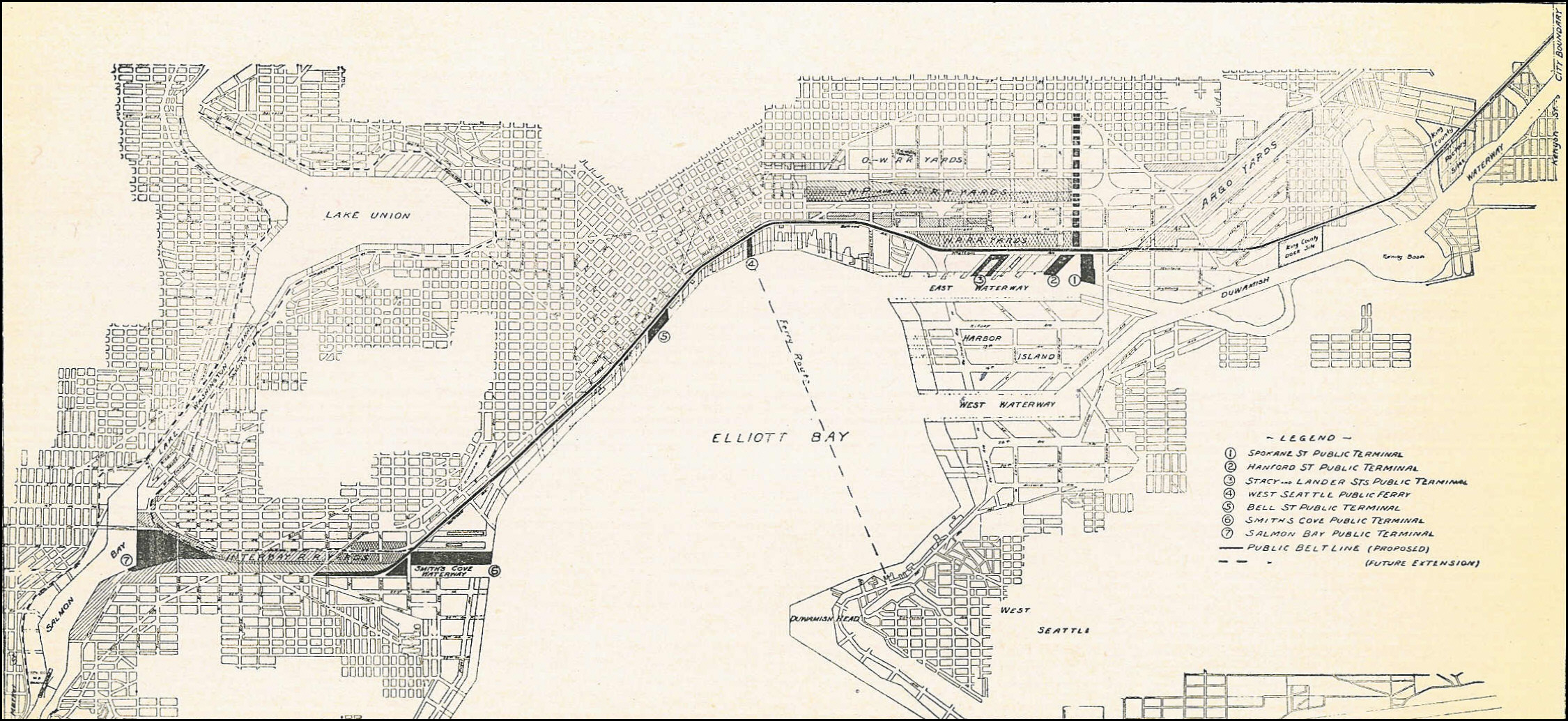
The City of Seattle Harbor Department Map of Central Waterfront District, February 1918.png - Jmabel
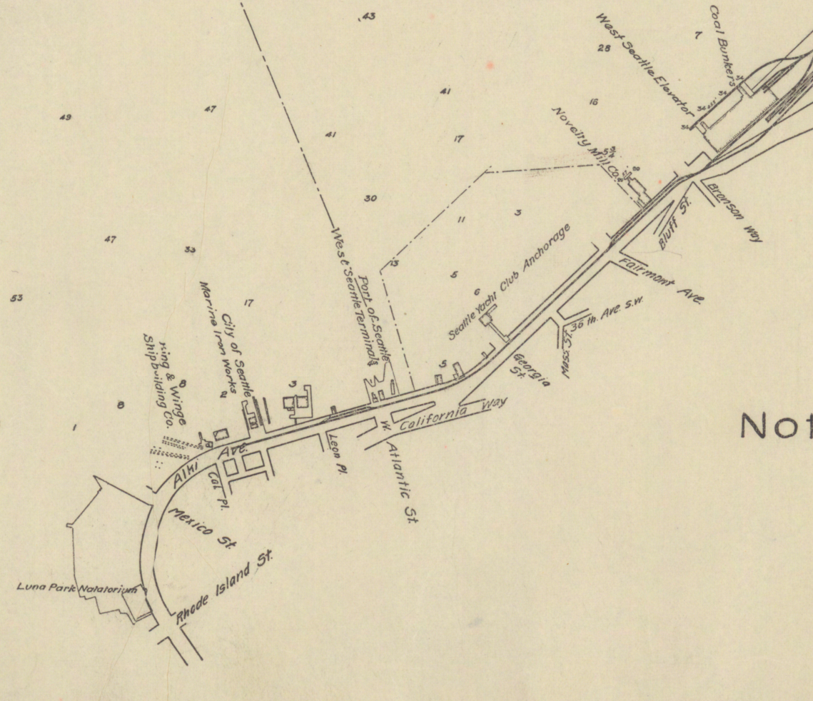
West Seattle shore from Duwamish head to the mill and grain elevator, 1918.png - Jmabel

Map of Definite Location of the Seattle-Tacoma Interban Railway From Station 100+88.8 to Station 365+68.5 Pierce County Wash. - NARA - 6093761.jpg - US National Archives bot

Bird's Eye View, City of Seattle and vicinity, 1904 (MAPS 63).jpg - BMacZeroBot

Bird's-eye View of the City of Seattle, Puget Sound, Washington Territory, 1878 (MAPS 64).jpg - BMacZeroBot

Parks, playgrounds and boulevards of the city of Seattle - Issued by the Board of Park Commisioners - btv1b53081392s.jpg - Gzen92Bot

Seattle City Light line service dispatcher, 1960 (52243650606).jpg - Jmabel

Battle of Seattle map, January 1, 1856 - DPLA - ff9b8afdece6380426ca0e3d238eb7d0.jpg - DPLA bot

Battle of Seattle, January 28, 1856 - DPLA - c9eb2629ae67034ed6e622aa45ecd01f.jpg - DPLA bot

Pacific Builder and Engineer, v. 10, no. 10, Sept. 3, 1910 - DPLA - 0b8ae0dccd2213ee417f56e5a58b9324 (page 26).jpg - DPLA bot

Map of Seattle Harbor, circa 1971 (52409434495).jpg - Jmabel

Sea Gull's View of Seattle map, 1927 (MOHAI 13255).jpg - BMacZeroBot

Map of Camp Long, Seattle, 1969 (53155402850).jpg - Jmabel

"Negro Population Seattle 1960" map (53167019351).jpg - Jmabel
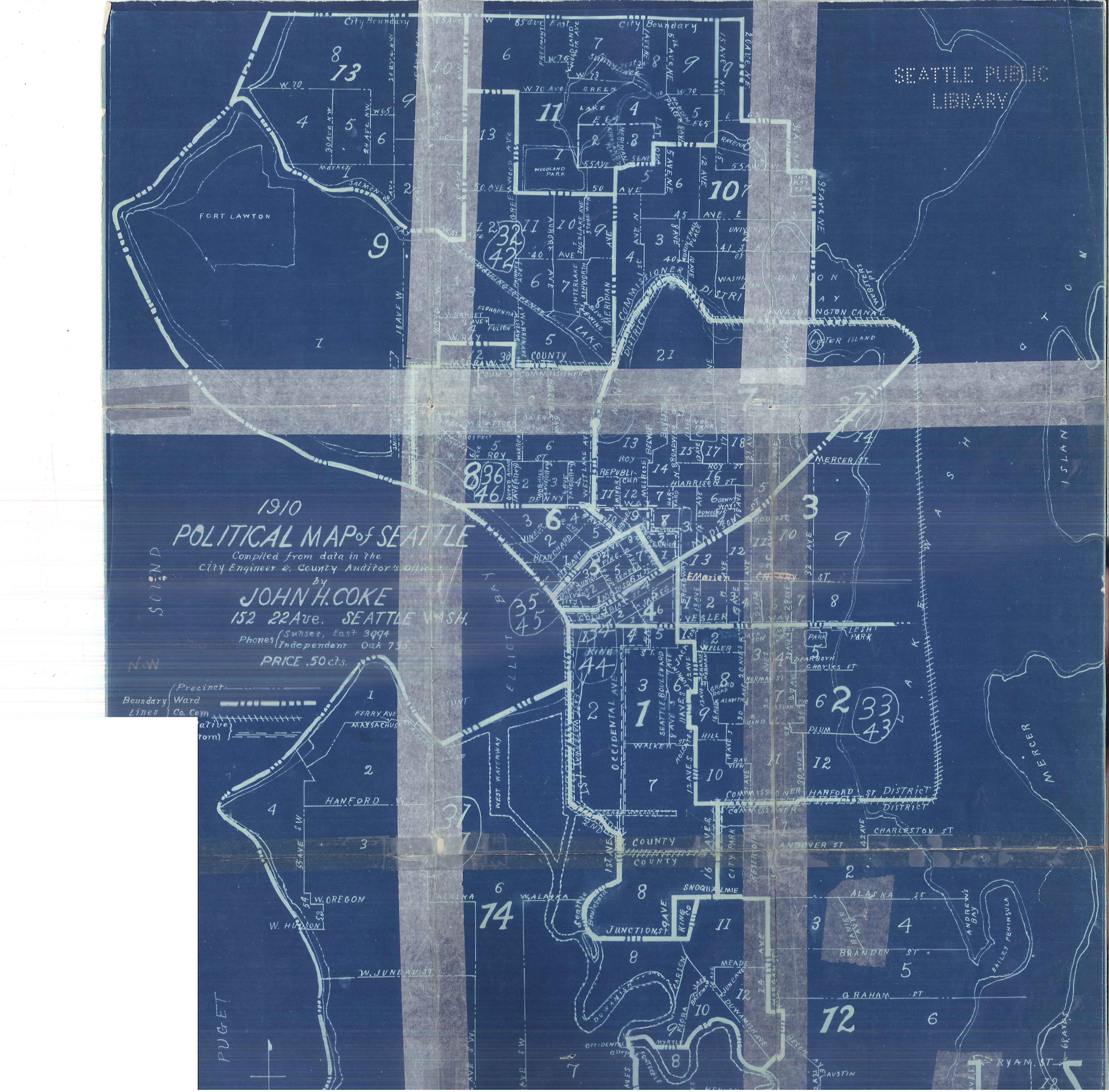
Political map of Seattle, 1910 (53362717124).jpg - Jmabel

Denny Regrade District, Seattle, 1928 (MOHAI 13446).jpg - BMacZeroBot

Contour map of Seattle, 1938 (54036050014).jpg - Jmabel

Seattle park bond issue precinct result map, 1954 (54211228225).jpg - Jmabel

Map of High Point, West Seattle, 1944 (54371655803).jpg - Jmabel

Bogue Plan Map 12 - Lake Union Waterfront and street grid.jpg - Jmabel