Wikimedi'Òc
Modes d'emploi

Cet album fait partie des albums
Cet album photos contient les sous-albums suivants :


Plan of Merjee on the Malabar coast in 14° 41'N. - by Elias Bates, 1725 ; publ. by A. Dalrymple ; J. Russell sculp. - btv1b8593186k.jpg - Gzen92Bot

Comptee on the Malabar coast - by Elias Bates, 1725 ; publ. by A. Dalrymple ; J. Russell sculp. ; the hills and c. by B. Henry - btv1b85931870.jpg - Gzen92Bot

Scetch of Boncout ; Sketch of Bassalore from an english MS. - publ. by A. Dalrymple ; writing by W.H. - btv1b8593170q.jpg - Gzen92Bot

Chart of part of the Malabar coast - by John Mc Cluer, 1789 and 1790 ; W. Harrison sc. - btv1b53257820k.jpg - Gzen92Bot

Dalrymple 1791 City and Environs of Sirengampatanne or Seringapatnam orientalrepertor01dalr 0658.jpg - Kognos

Dalrymple 1791 Colar orientalrepertor01dalr 0662.jpg - Kognos

EstadoInd.jpg - Bubamara

Wikipedia OldMysore.jpg - File Upload Bot (Magnus Manske)
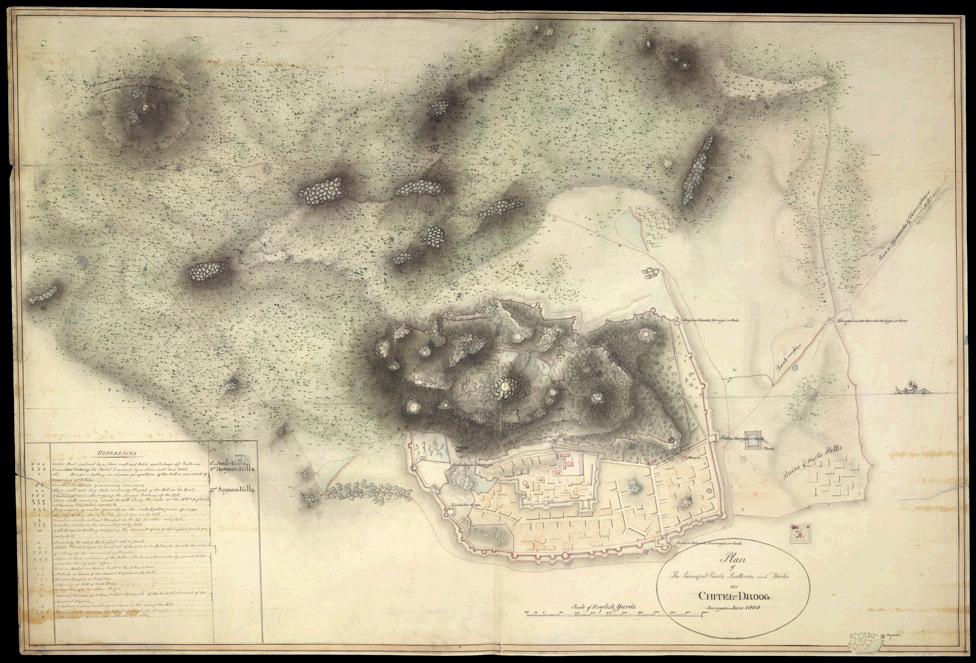
Plan of the Chitradurg Fort.JPG - Nvvchar
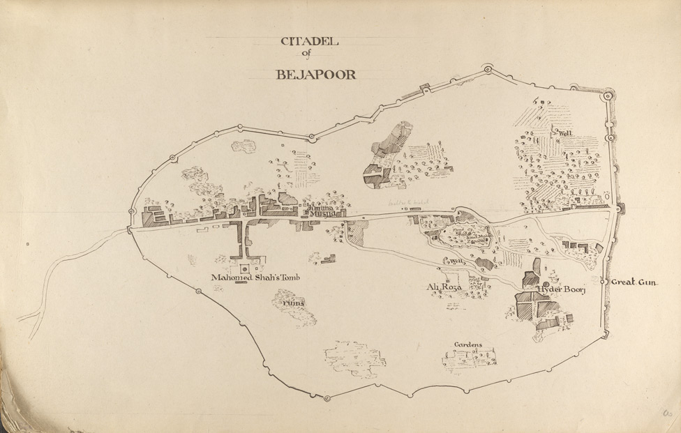
F.3' Citadel of Bejapoor. Plan..jpg - Nvvchar

Mysore in 1704 Joppen.jpg - Abecedare

Malabar district.jpg - BishkekRocks

Plan of Seringapatam.jpg - Liandrei
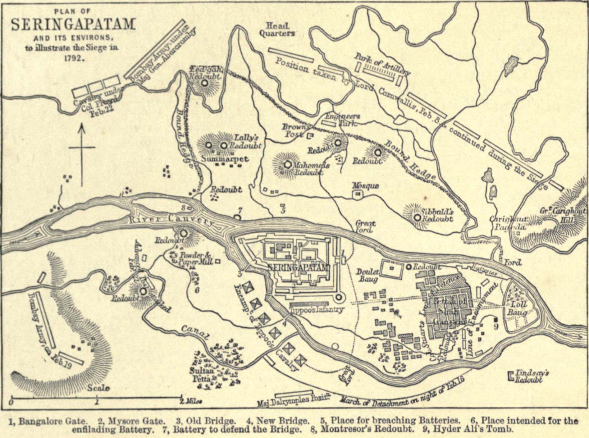
Plan of Seringapatam and its environs.jpg - Spellcast
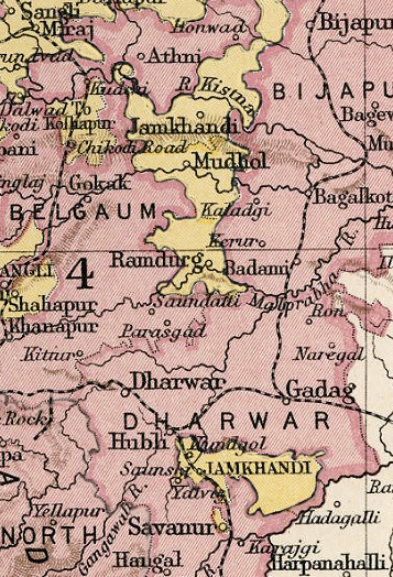
JamkhandiKart.jpg - File Upload Bot (Magnus Manske)

South Kanara.jpg - BishkekRocks

1834 S.D.U.K. Map of Bombay Presidency and Goa, India - Geographicus - IndiaIII-sduk-1834.jpg - BotMultichill

1800 Faden Rennell Wall Map of India - Geographicus - India-faden-1795.jpg - BotMultichillT

1793 Faden Wall Map of India - Geographicus - India-faden-1793.jpg - BotMultichillT

Overland trade routes through the Deccan.jpg - Napoleon 100

Hampi Murray.jpg - Shyamal

Bijapur Murray.jpg - Shyamal

A map of India, showing Malabar, Madura and Cormeddel Wellcome L0038175.jpg - Fæ

Hampi Ruins of Vijaynagar India Map 1911.jpg - Nizil Shah

Madikeri map.jpg - Shyamal

Bellary 1854.jpg - Shyamal

Bijapur City and Suburb Places of Interest 1896 map.jpg - Wdwdbot

North Kanara 1896.jpg - Nizil Shah

Bijapur district 1896.jpg - Nizil Shah

A map published in 1820, Hampi, Vijayanagara ruins.jpg - Ms Sarah Welch

103 of 'A Handbook for the use of Visitors to Seringapatam' (11250540086).jpg - Artix Kreiger 2
1800 Map of Peninsular India-1795.jpg - Shyamal

Mysore 1854.jpg - Shyamal

Mercara 1854.jpg - Shyamal

Bangalore district 1854.jpg - Shyamal

Bellary 1854 Pharoah.jpg - Shyamal
Shimoga 1854.jpg - Shyamal
S Canara 1854.jpg - Shyamal

N Canara 1854.jpg - Shyamal

Chitradurga 1854.jpg - Shyamal

Chitradurga map.png - Shyamal

Hampi Ruins Map.jpg - Shyamal

58 A 09 Mysore State (1910).jpg - Shyamal

North Kanara mission map.jpg - Shyamal

1801 - 20 - 61 Fort and Petta of Muddukayray.jpg - Shyamal

1801 - 20 - 30(A) Territories of Mysore.jpg - Shyamal

1801 - 20 - 29(A) 1806 Districts interchanged between EE India Co and Rajah of Mysore.jpg - Shyamal

1801 - 20 - 29 1806 Districts proposed to be enterchanged between EE India Co and Rajah of Mysore.jpg - Shyamal

Admiralty Chart No 827 Vengurla to Cape Comorin, Published 1877.jpg - Kognos

Admiralty Chart No 745 Netrani to Mangalore, Published 1902.jpg - Kognos

Admiralty Chart No 746 Mulki to Mount Dilli, Published 1858.jpg - Kognos

Admiralty Chart No 827 Vengurla to Cape Comorin, Published 1877, New Edition 1914.jpg - Kognos

Admiralty Chart No 782 Bombay to Carwar Head, Published 1791.jpg - Kognos
60The South Indian Railway.jpg - Wuselig