Wikimedi'Òc
Modes d'emploi

Cet album fait partie des albums
Cet album photos contient les sous-albums suivants :


Island of Guernesey - btv1b8439195h.jpg - Gzen92Bot

2.me carte particuliere des costes de Normandie contenant les costes du Cotentin depuis la Pointe de la Percée Jusqu'a Granville ou sont Comprises les Isles de Jersey, Grenezey, Cers, et Aurigny, avec les Isles de... - btv1b53053271w.jpg - Gzen92Bot

2.me carte particuliere des costes de Normandie contenant les costes du Cotentin depuis la Pointe de la Percée Jusqu'a Granville ou sont Comprises les Isles de Jersey, Grenezey, Cers, et Aurigny, avec les Isles de... - btv1b530531435.jpg - Gzen92Bot

A new and correct chart of the islands of Guernsey, Sark, Arme and Jethow - btv1b530130747.jpg - Gzen92Bot

A new and correct chart of the islands of Jersey, Guernsey, Alderney, and ca - with the coast of France, from Neville to the Iles of Brehat - btv1b53151927r.jpg - Gzen92Bot

A new and exact chart of the islands of Guernsey, Sercq, Herm and Jethou - btv1b53013047b.jpg - Gzen92Bot

A new and exact chart of the islands of Guernsey, Sercq, Herm and Jethou - btv1b530129855.jpg - Gzen92Bot

Holy Iland ; Garnsey ; Farne ; Iarsey - Performed by John Speede ; Jodocus Hondius Anno Domini 1610 - btv1b53225407r (2 of 3).jpg - Gzen92Bot

The Islets of the Channel 1858 Walter Cooper Dendy t.jpg - Man vyi

Island of Jethou.png - Ratzer

Bellin guernsey 1757.jpg - Ratzer

17th Century maps of Holy Island, Guernsey, Farne Island, and Jersey.JPG - Seriykotik

Guernsey and Alderney with Island of Sark 1748.jpg - Ratzer

Guernsey old map.jpg - Ratzer

Le petit flambeau-31.png - Als33120

An historical account of the island of Guernsey Fleuron T138160-1.png - Fæ
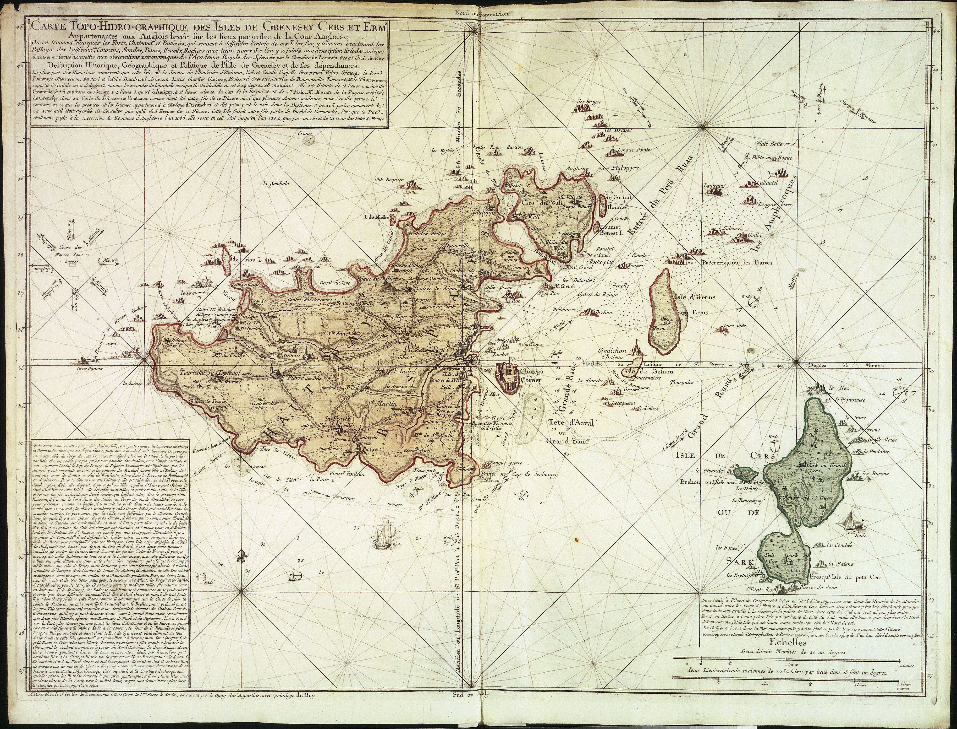
Guernsey map by Jean de Beaurain.jpg - Ratzer
A new and exact chart of the islands of Guernsey, Sercq, Herm and Jethou; in which all the rocks, shoals and other dangers near those islands are carefully laid down- also the various soundings, and the ebbing and flowing of RMG F0152.tiff - Fæ
An accurate chart of the islands of Alderney and Burhou and also of the Caskets, shewing all the rocks near them; likewise the soundings, course of the tides and the anchorage around Alderney. Survey'd and drawn by Nicholas RMG F0153.tiff - Fæ

580 of 'The National Gazetteer of Great Britain and Ireland. (Edited by N. E. S. A. H.)' (11086170246).jpg - FlickreviewR 2

77 of 'The Channel Islands ... With illustrations drawn by P. J. Naftel (and with maps)' (11239355646).jpg - Artix Kreiger 2

77 of '(The Channel Islands ... With illustrations drawn by P. J. Naftel (and with maps).)' (11048216665).jpg - Artix Kreiger 2

686 of '(The Imperial Gazetteer; a general dictionary of geography, physical, political, statistical and descriptive ... Edited by W. G. Blackie ... With ... illustrations, etc.)' (11104550964).jpg - Artix Kreiger 2

79 of 'Guernsey and its Bailiwick. A guide and a gossip, with notices of Sark, Herm, Jethou, and Alderney ... Maps, plans, and illustrations. Second edition, revised' (11203807543).jpg - Artix Kreiger 2

83 of 'Guernsey and its Bailiwick. A guide and a gossip, with notices of Sark, Herm, Jethou, and Alderney ... Maps, plans, and illustrations. Second edition, revised' (11207430283).jpg - Artix Kreiger 2

85 of 'Guernsey and its Bailiwick. A guide and a gossip, with notices of Sark, Herm, Jethou, and Alderney ... Maps, plans, and illustrations. Second edition, revised' (11206947494).jpg - Artix Kreiger 2

96 of 'Guernsey and its Bailiwick. A guide and a gossip, with notices of Sark, Herm, Jethou, and Alderney ... Maps, plans, and illustrations. Second edition, revised' (11204435184).jpg - FlickreviewR 2

216 of 'A Farmer's Vacation. ... Reprinted (with additions) from Scribner's Monthly. Illustrated' (11260922694).jpg - Artix Kreiger 2

Holy iland ; Garnsey ; Farne ; Iarsey - CBT 6599427.jpg - Francesco Serra (BIBCOMTN)

Ordnance Survey Map of Guernsey, Published 1934.jpg - Kognos

Hurd Deep from cropped Admiralty Chart No 2649 English Channel Western Portion Published 1955.jpg - Djm-leighpark

Admiralty Chart No 2668 Lannion to Erquy, Published 1968.jpg - Kognos

Admiralty Chart No 262b Guernsey Herm and Sark Middle Sheet, Published 1863.jpg - Kognos

Admiralty Chart No 3140 St. Peter Port, Published 1900.jpg - Kognos

Admiralty Chart No 3400 Guernsey Herm and Sark, Published 1961.jpg - Kognos

Admiralty Chart No 262c Guernsey Western Part, Published 1954.jpg - Kognos

Tozer's road map of Guernsey - btv1b53058836g.jpg - Gzen92Bot

Ordnance Survey map of Guernsey. Surveyed in 1898-99. Revised in 1933 - btv1b532133795.jpg - Gzen92Bot

The road of Cherbourg and its environs in 1784 ; A survey of the islands of Guernsey, Sark, Herm & Jethou in 1806 - by Capt. Hurd R.N., hydrographer to the Admiralty ; J.W. sculp. - btv1b53151931g.jpg - Gzen92Bot
The Island of Guernsey RMG F2027.tiff - Fæ