Wikimedi'Òc
Modes d'emploi

Cet album fait partie des albums
Cet album photos contient les sous-albums suivants :


1852 map BristolCounty Massachusetts byWalling BPL 10676.png - M2545
City of Taunton (9136027953).jpg - File Upload Bot (Magnus Manske)

City of Taunton (9136027805).jpg - File Upload Bot (Magnus Manske)
City of Taunton (9138250394).jpg - File Upload Bot (Magnus Manske)

City of Taunton (9136027577).jpg - File Upload Bot (Magnus Manske)

Plan of the Dighton and Somerset Rail Road, circa 1860s.jpg - Pi.1415926535

Map of the town of Norton, Bristol County, Mass. (3855702303).jpg - File Upload Bot (Magnus Manske)

Map of the town of Fairhaven, Bristol County, Mass. (3856489454).jpg - File Upload Bot (Magnus Manske)

Map of the town of Raynham, Bristol County, Mass. (3720673082).jpg - File Upload Bot (Magnus Manske)

Map of the town of Easton, Bristol County, Massachusetts (2674190301).jpg - File Upload Bot (Magnus Manske)

Map of the county of Bristol, Massachusetts (2674987340).jpg - File Upload Bot (Magnus Manske)

The Old Dartmouth historical sketches (1903) (14590695079).jpg - Fæ

Trolley trips through New England (1900) (14777468974).jpg - Fæ
Bristol County Massachusetts 1852 map LOC la000308.tif - Kzirkel

Cyclists' road map of Massachusetts part 9 (14959489692).jpg - Ser Amantio di Nicolao

8 of 'Colonial Times on Buzzard's Bay. (With a map.)' (11198033963).jpg - Artix Kreiger 2

Road map of Bristol Co., Mass. LOC gm70005260.jpg - Fæ
Map of the Town of Attleborough, Bristol County, Massachusetts LOC 84695709.tif - Fæ

Map of the Town of Attleborough, Bristol County, Massachusetts LOC 84695709.jpg - Fæ
Bristol County, Massachusetts LOC 81690017.tif - Fæ

Bristol County, Massachusetts LOC 81690017.jpg - Fæ
Town of Westport. LOC gm71000573.tif - Fæ

Town of Westport. LOC gm71000573.jpg - Fæ

Admiralty Chart No 2880 Massachusetts New Bedford Harbour, Published 1862.jpg - Kognos

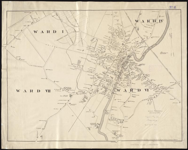
1895 map of Taunton, Massachusetts (east part).png - Pi.1415926535

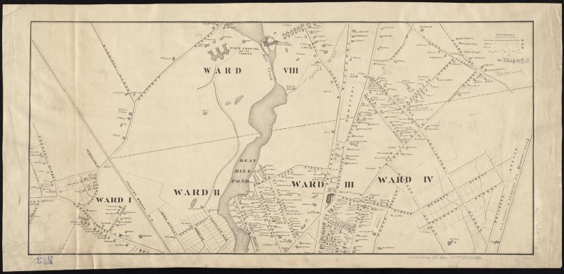
1895 map of Taunton, Massachusetts (west part).png - Pi.1415926535
Map-of-Norton-1830.pdf - Forestswampfriend