Wikimedi'Òc
Modes d'emploi

Cet album fait partie des albums
Cet album photos contient les sous-albums suivants :


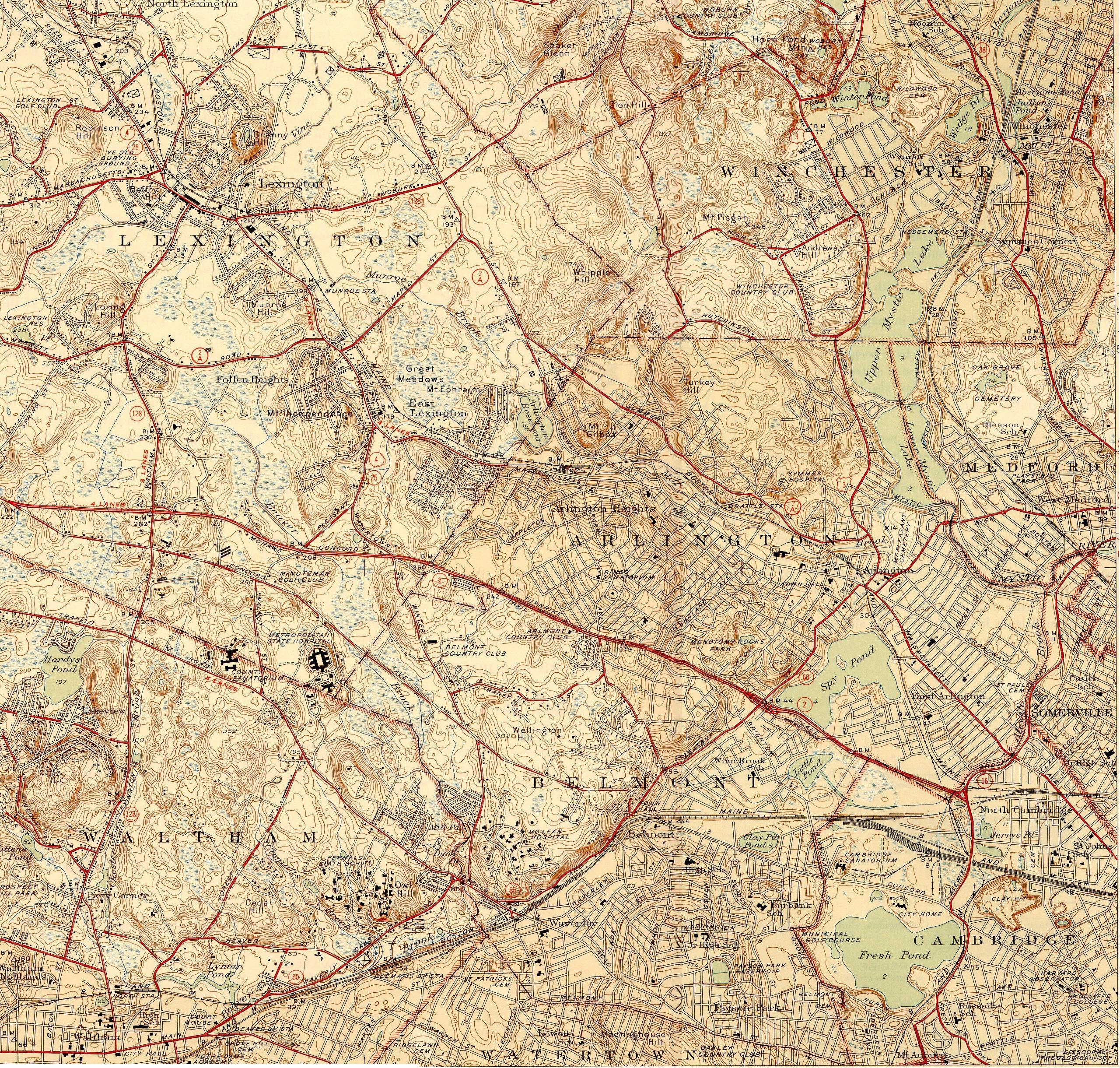
Topographic maps of Arlington, Belmont, Lexington Massachusetts 1946.jpg - Daderot

Plan of building lots on the "Kimball" Estate Arlington, Mass. (9475356544).jpg - Opencooper
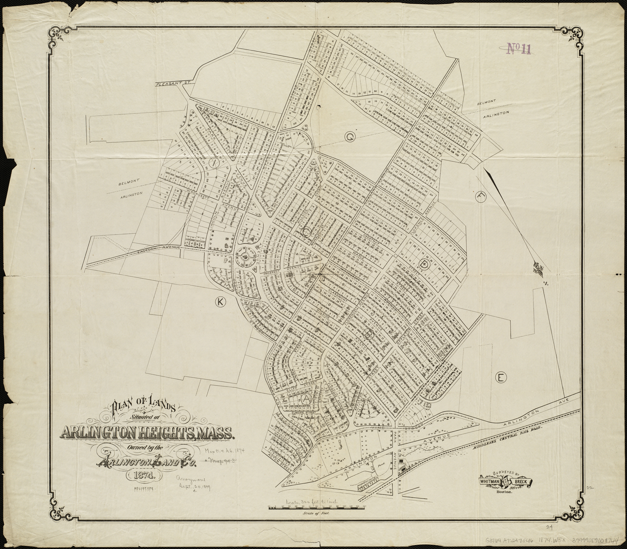
Plan of lands situated at Arlington Heights, Mass. (3120134621).jpg - File Upload Bot (Magnus Manske)

Arlington, Massachusetts (2675930216).jpg - File Upload Bot (Magnus Manske)

The birds of the Cambridge region of Massachusetts (1906) (20804312251).jpg - Fæ

Arlington, Massachusetts, 1884. LOC 2011589045.jpg - Fæ

1940 Census Enumeration District Maps - Massachusetts - Middlesex County - Arlington - ED 9-3 - ED 9-39 - NARA - 5832396 (page 1).jpg - US National Archives bot

1940 Census Enumeration District Maps - Massachusetts - Middlesex County - Arlington - ED 9-3 - ED 9-39 - NARA - 5832396 (page 2).jpg - US National Archives bot

1950 Census Enumeration District Maps - Massachusetts (MA) - Middlesex County - Arlington - ED 9-4 to 70 - NARA - 12549101.jpg - US National Archives bot

Fresh Pond and its Surroundings, about 1866, by Charles D. Elliot, May 1906 - reprinted in Fresh Pond, The History of a Cambridge Landscape, by Jill Sinclair, 2009 - Fresh Pond, MA - DSC02556.jpg - Daderot

Map of Boston and its vicinity (detail 1), by John G. Hales, 1819 - reprinted in Fresh Pond, The History of a Cambridge Landscape, by Jill Sinclair, 2009 - Fresh Pond, MA - DSC02583.jpg - Daderot

Map of Boston and its vicinity (detail 2), by John G. Hales, 1819 - reprinted in Fresh Pond, The History of a Cambridge Landscape, by Jill Sinclair, 2009 - Fresh Pond, MA - DSC02588.jpg - Daderot

Map of Cambridge (detail) by John Hales, 1830 - reprinted in Fresh Pond, The History of a Cambridge Landscape, by Jill Sinclair, 2009 - Fresh Pond, MA - DSC02574.jpg - Daderot

West Cambridge (Arlington), Massachusetts - Henry Francis Walling, 1856 - Library of Congress master-gmd-gmd376-g3763-g3763m-la000316Z.jpg - Daderot
Arlington's borders, up to 1907.pdf - Daderot

Arlington, Massachusetts, 1884, from the Digital Commonwealth - commonwealth x633fc56f.jpg - Daderot

1830 Plan of West Cambridge (Arlington), Massachusetts by John Groves Hales, from the Digital Commonwealth - commonwealth 25152f94h.jpg - Daderot

1836 Map of the water region of the county of Middlesex exhibiting the mode of supplying Boston & Charlestown with soft water from Spot and Mystic Ponds, by R. H. Eddy, from the Digital Commonwealth - commonwealth wd376670z.jpg - Daderot

1889 Ten miles around Lynn by William T. Oliver, from the Digital Commonwealth - commonwealth wd3762152.jpg - Daderot

1874 Plan of lands situated at Arlington Heights, Mass, owned by the Arlington Land Co, by Whitman & Breck, from the Digital Commonwealth - commonwealth 1257bb39n.jpg - Daderot

1894 map of Arlington and Belmont, Mass. by Edward A. Jones from Arlington City Directory (IA arlingtoncitydir1894arli) (page 11 crop).jpg - Ooligan

1807 (circa) Map of Cambridge roads, by Peter Tufts, Jr., from the Digital Commonwealth - commonwealth wd378h641.jpg - Daderot

Atlas of Middlesex County, Massachusetts, by Geo. H. Walker & Co., 1889, from the Digital Commonwealth - 48 commonwealth 1j92k2337 image access full.jpg - Enyavar

Atlas of Middlesex County, Massachusetts, by Geo. H. Walker & Co., 1889, from the Digital Commonwealth - 53 commonwealth 1j92k2337 image access full.jpg - Daderot

Atlas of Middlesex County, Massachusetts, by Geo. H. Walker & Co., 1889, from the Digital Commonwealth - 54 commonwealth 1j92k2337 image access full.jpg - Daderot

Atlas of Middlesex County, Massachusetts, by Geo. H. Walker & Co., 1889, from the Digital Commonwealth - 55 commonwealth 1j92k2337 image access full.jpg - Daderot

Atlas of Middlesex County, Massachusetts, by Geo. H. Walker & Co., 1889, from the Digital Commonwealth - 56 commonwealth 1j92k2337 image access full.jpg - Enyavar

Atlas of Middlesex County, Massachusetts, by Geo. H. Walker & Co., 1889, from the Digital Commonwealth - 57 commonwealth 1j92k2337 image access full.jpg - Daderot
Atlas of the boundaries of the town of Arlington, Middlesex County, by the Board of Harbor and Land Commissioners of Massachusetts, 1901, from the Massachusetts Archives - ocm15068160.pdf - Daderot

1871 Map of Somerville, Arlington & Belmont, engraved for the Somerville, Arlington & Belmont directory, by Mason & Elliot, from the New York Public Library - fd3862f0-6c76-0134-da11-00505686a51c.jpg - Daderot