Wikimedi'Òc
Modes d'emploi

Cet album fait partie des albums
Cet album photos contient les sous-albums suivants :


The life and times of Thomas Smith, 1745-1809, a Pennsylvania member of the Continental congress (1904) (14770368671).jpg - Fæ

The life and times of Thomas Smith, 1745-1809, a Pennsylvania member of the Continental congress (1904) (14587055607).jpg - Fæ

The life and times of Thomas Smith, 1745-1809, a Pennsylvania member of the Continental congress (1904) (14586840920).jpg - Fæ

The life and times of Thomas Smith, 1745-1809, a Pennsylvania member of the Continental congress (1904) (14586912288).jpg - Fæ

The life and times of Thomas Smith, 1745-1809, a Pennsylvania member of the Continental congress (1904) (14587057887).jpg - Fæ

The life and times of Thomas Smith, 1745-1809, a Pennsylvania member of the Continental congress (1904) (14771179114).jpg - Fæ

The life and times of Thomas Smith, 1745-1809, a Pennsylvania member of the Continental congress (1904) (14773540385).jpg - Fæ

The life and times of Thomas Smith, 1745-1809, a Pennsylvania member of the Continental congress (1904) (14586836090).jpg - Fæ

The life and times of Thomas Smith, 1745-1809, a Pennsylvania member of the Continental congress (1904) (14586901808).jpg - Fæ

The life and times of Thomas Smith, 1745-1809, a Pennsylvania member of the Continental congress (1904) (14750541706).jpg - Fæ

P051 Thomas Smith Virginia Claims.png - Enyavar

Walking purchase en.png - Nikater

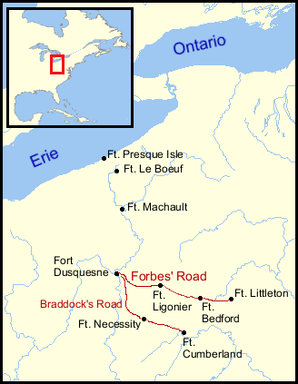
Forts at Forks of Ohio.png - OgreBot

The Wedge.png - Exterioramoeba

Pennsylvania (1775-1783).jpg - Muhranoff

1937 original railroads in Pittsburgh.jpg - SPUI~commonswiki

10 of 'Pennsylvania, colony and commonwealth' (11242562284).jpg - Artix Kreiger 2
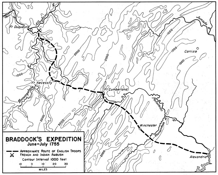
Braddock 1755.jpg - Feydey

1948 original railroads in Philadelphia.jpg - SPUI~commonswiki

NativeTowns Pittsburgh.png - Tomcool~commonswiki
French British Forts 1753 1758.png - Tomcool~commonswiki

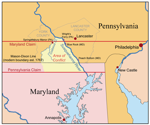
Ctwestclaims.png - Ras67

Penncolony.png - Kmusser

Marycolony.png - Ras67

Pennsylvania land purchases.png - Nikater

Big Runaway Map.PNG - Ruhrfisch

Daniel Hughes River Map.PNG - Ruhrfisch
Cresapwarmap.png - Kmusser

National road map.png - PxMa

NY-NJ-retreat-1776.jpg - Red4tribe

Fort Ancient Monongahela cultures HRoe 2010.jpg - Heironymous Rowe

Nya Sverige.svg - Arnapha

NY-NJ-retreat-1776.svg - Luxrunner
Battle of Brandywine, Sept. 11th 1777. NYPL434988.tiff - Fæ

The Pennsylvania-German Society - (Publications) (1891) (14762171656).jpg - SteinsplitterBot

Map modeling in geography - including the use of sand, clay putty, paper pulp, plaster of Paris, and other materials - also chalk modeling in its adaptation to purposes of illustration (1894) (14598018097).jpg - SteinsplitterBot

Map modeling in geography - including the use of sand, clay putty, paper pulp, plaster of Paris, and other materials - also chalk modeling in its adaptation to purposes of illustration (1894) (14782177544).jpg - SteinsplitterBot

History of Franklin county, Pennsylvania, containing a history of the county, its townships, towns, villages, schools, churches, industries...biographies- history of Pennsylvania, statistical and (14595453739).jpg - SteinsplitterBot

USGS topo Map-Centerville Borough below Malden, Denbo Heights to West Brownsville Washington County Pennsylvania with PA-43, US-40 & Old National Road.png - Fabartus

USGS topo Map-Malden-Denbo Heights neighborhoods of Centerville region, Washington County Pennsylvania with PA-43, US-40 & Old National Road.png - Fabartus

USGS topo Map-Malden neighborhood of Centerville region, Washington County Pennsylvania with PA-43, US-40 & Old National Road.png - Fabartus

Migration of PresqueIsle.jpg - OgreBot
206 of 'A History of the United States for schools ... With topical analysis, suggestive questions ... by F. A. Hill. (With maps.)' (11304515964).jpg - Artix Kreiger 2

227 of 'Map Modeling in Geography, including the use of sand, clay, putty, paper pulp, plaster of Paris ... Also Chalk Modeling in its adaptation to purposes of illustration. Fully illustrated' (11133363404).jpg - Artix Kreiger 2

249 of 'Map Modeling in Geography, including the use of sand, clay, putty, paper pulp, plaster of Paris ... Also Chalk Modeling in its adaptation to purposes of illustration. Fully illustrated' (11231414815).jpg - FlickreviewR 2

255 of 'Map Modeling in Geography, including the use of sand, clay, putty, paper pulp, plaster of Paris ... Also Chalk Modeling in its adaptation to purposes of illustration. Fully illustrated' (11233178114).jpg - FlickreviewR 2

251 of 'Map Modeling in Geography, including the use of sand, clay, putty, paper pulp, plaster of Paris ... Also Chalk Modeling in its adaptation to purposes of illustration. Fully illustrated' (11231095855).jpg - FlickreviewR 2

253 of 'Map Modeling in Geography, including the use of sand, clay, putty, paper pulp, plaster of Paris ... Also Chalk Modeling in its adaptation to purposes of illustration. Fully illustrated' (11231101005).jpg - FlickreviewR 2

1125 of 'History of Fayette County, Pennsylvania, with biographical sketches ... Illustrated' (11150255266).jpg - Artix Kreiger 2

Events of the Reading Massacre.png - GreenMeansGo

Atlas of Battles of the American Revolution, Sheet 8- A Plan of the Provinces of Pensylvania, and East & West New Jersey, whewing the Operations of the Royal Army under the Command of their Excellancies Sir. Wil(...) - NARA - 102279696.jpg - US National Archives bot

Pennsylvania women's suffrage referundum map 1915, produced by Pennsylvania Men's League for Women's Suffrage.jpg - Megalibrarygirl

Disputed Land (50120993901).jpg - Hhm8

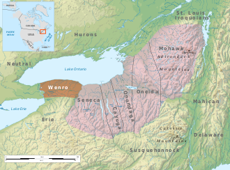
Wenro Territory ca1630 map-en.svg - Ikonact

NY-NJ-retreat-1776-es.svg - Rowanwindwhistler

Map from Indian land cessions in the United States by Charles C. Royce 48.jpg - Jengod

Delawaremap-1.png - PCRMuncie