Wikimedi'Òc
Modes d'emploi

Cet album fait partie des albums
Cet album photos contient les sous-albums suivants :


Paterson nj.png - Pacoperez6
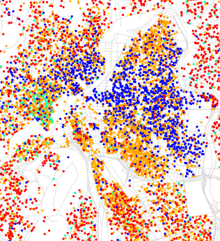
Race and ethnicity 2010- Paterson.png - Monopoly31121993

EB9 New York - City and vicinity.jpg - Bob Burkhardt
PHOTOCOPY OF MAP - 1835- TOWN OF PATERSON, NEW JERSEY- 1835. (photo made from a 5x7 negative) - Great Falls-S. U. M. Historic District, Oliver Street, Paterson, Passaic County, NJ HAER NJ,16-PAT,15-1.tif - Enyavar
Todd and Rafferty Machine Company, Van Houten Street and McGee Alley, Paterson, Passaic County, NJ HAER NJ,16-PAT,22- (sheet 1 of 3).tif - Fæ
Todd and Rafferty Machine Company, Van Houten Street and McGee Alley, Paterson, Passaic County, NJ HAER NJ,16-PAT,22- (sheet 2 of 3).tif - Fæ

Great Falls-S. U. M. Historic District, Oliver Street, Paterson, Passaic County, NJ HAER NJ,16-PAT,15- (sheet 4 of 5).png - Fæ

Census Bureau map of Paterson, New Jersey.png - GifTagger

Burned District, Paterson, NJ, Feb 1902.jpg - PlayswithfireNJ

Map of New Jersey highlighting City of Paterson.svg - Wugapodes

601 of 'History of Bergen and Passaic Counties, New Jersey, with biographical sketches of many of its pioneers and prominent men ... Compiled under the supervision of W. W. Clayton, assisted by W. Nelson ... Illustrated' (11157769293).jpg - Artix Kreiger 2

00079.BP--Coal pocket--Plan of approach--Mashall and Van Winke Street--Paterson, NJ (874c7824-0cd3-46d4-bb46-f916ff4b1448).jpg - BMacZeroBot

USGS Paterson New Jersey 1900 topo.jpg - Jengod