Wikimedi'Òc
Modes d'emploi

Cet album fait partie des albums
Cet album photos contient les sous-albums suivants :


Map of Oahu 3.svg - Justinkunimune

Hawaii Islands - Oahu.PNG - Michiel1972
OAHU.png - W.wolny
Oahu blank map.svg - Historicair

Oahu.svg - Historicair

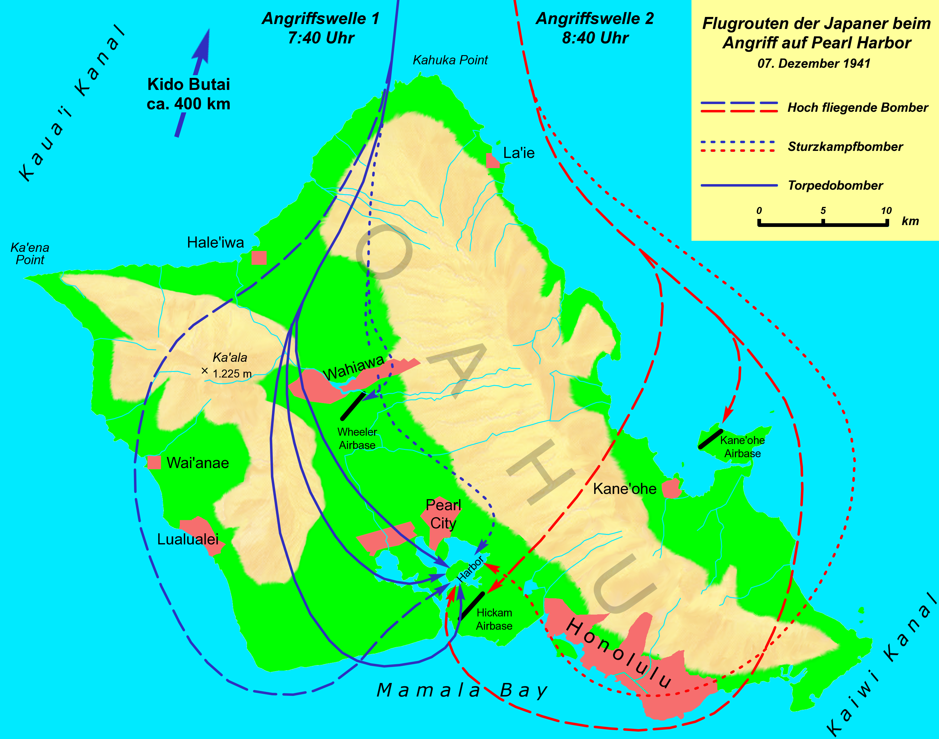
Pearl Harbor 1941.svg - Historicair
HIMap-doton-BarbersPointHousing.PNG - SieBot
HIMap-doton-Heeia.PNG - SieBot
HIMap-doton-Kaaawa.PNG - SieBot
HIMap-doton-HickhamAFB.PNG - SieBot
HIMap-doton-Kahaluu.PNG - SieBot
HIMap-doton-Kahuku.PNG - SieBot
HIMap-doton-Kaneohe.PNG - SieBot
HIMap-doton-KawelaBay.PNG - SieBot
HIMap-doton-Makaha.PNG - SieBot
HIMap-doton-Makakilo.PNG - SieBot
HIMap-doton-Maunawili.PNG - SieBot
HIMap-doton-Mokuleia.PNG - SieBot
HIMap-doton-Nanakuli.PNG - SieBot
HIMap-doton-PearlCity.PNG - SieBot
HIMap-doton-Pupukea.PNG - SieBot
HIMap-doton-SchofieldBarracks.PNG - SieBot
HIMap-doton-Waiahole.PNG - SieBot
HIMap-doton-Waimalu.PNG - SieBot
HIMap-doton-Waimanalo.PNG - SieBot
HIMap-doton-Waipahu.PNG - SieBot
HIMap-doton-WaipioAcres.PNG - SieBot
HIMap-doton-WhitmoreVillage.PNG - SieBot

Interstate H201 map.png - Artisol2345~commonswiki

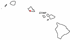
Oahu Island location (Southeastern Islands).png - D kuba

USSArizonaMemorialMap 2.PNG - H-stt

Oahu SRTM.JPG - Ian Furst

Oahu mk.svg - MacedonianBoy

PSM V67 D680 Map of ohau.png - Ineuw

Ahupuaa of Oahu.svg - Sn1per

Oahu Hawaiian Islands 1906.jpg - National Public Domain Archive

Pearl Harbor 1941 nl.svg - Citypeek

Map showing Pililaau loaction.jpg - USDProfessor

Sketch of Scene of Wednesday's Battle in Manoa, 1895.jpg - KAVEBEAR

Map of Oahu, Ursula Emerson, 1833.jpg - KAVEBEAR

Oahu be.svg - Frantishak

Natural history of Hawaii (Page 110) (7153452115).jpg - Fæ

Portfolio of maps of Spofford's new cabinet cyclopaedia - containing large scale colored maps of each state and territory in the United States, the provinces of Canada, America's new possessions, etc (14764386991).jpg - Fæ

Pearl Harbor 1941 en.svg - Wallach79

Map of Oahu 2.png - Mliu92

Relief Map of Oahu (a), photograph by Brother Bertram.jpg - AlohaKavebear

Relief Map of Oahu (b), photograph by Brother Bertram.jpg - AlohaKavebear

Relief Map of Oahu (c), photograph by Brother Bertram.jpg - AlohaKavebear

Hawaii Oahu-2-TF.jpg - Rtmi1

302 of '(Manual of Geology- treating of the principles of the science with special reference to American geological history ... Revised edition.)' (11303646033).jpg - Kilom691

ARMY WAR GAME. LT. COL. D.E. AULTMAN; LT. COL. J.A. SHIPTON; MAJOR L. WAHL; COL. GEORGE H. CAMERON; LT. COL. E D. ANDERSON; LT. COL. HENRY JERVEY LCCN2016867498.jpg - Fæ

Oahu 1938 USGS map.jpg - Ratzer
Hawaiian Government Survey; W. D. Alexander, Surveyor General, Oahu, Hawaiian Islands; map by C. J. Lyons, from trigonometic surveys by W. D. Alexander, C. J. Lyons, J. F. Brown, M. D. Monsarrat and LOC 98688461.tif - Fæ

Hawaiian Government Survey; W. D. Alexander, Surveyor General, Oahu, Hawaiian Islands; map by C. J. Lyons, from trigonometic surveys by W. D. Alexander, C. J. Lyons, J. F. Brown, M. D. Monsarrat and LOC 98688461.jpg - Fæ
Oahu, Hawaiian Islands LOC 2005625312.tif - Fæ

Oahu, Hawaiian Islands LOC 2005625312.jpg - Fæ
Sanborn Fire Insurance Map from Sugar Mill and Cannery, Hawaii County, Hawaii. LOC sanborn01553 001-1.tif - Fæ

Mouth and bar of Pearl River, Island of Oahu, Hawaiian Islands LOC 2010592866.jpg - Fæ
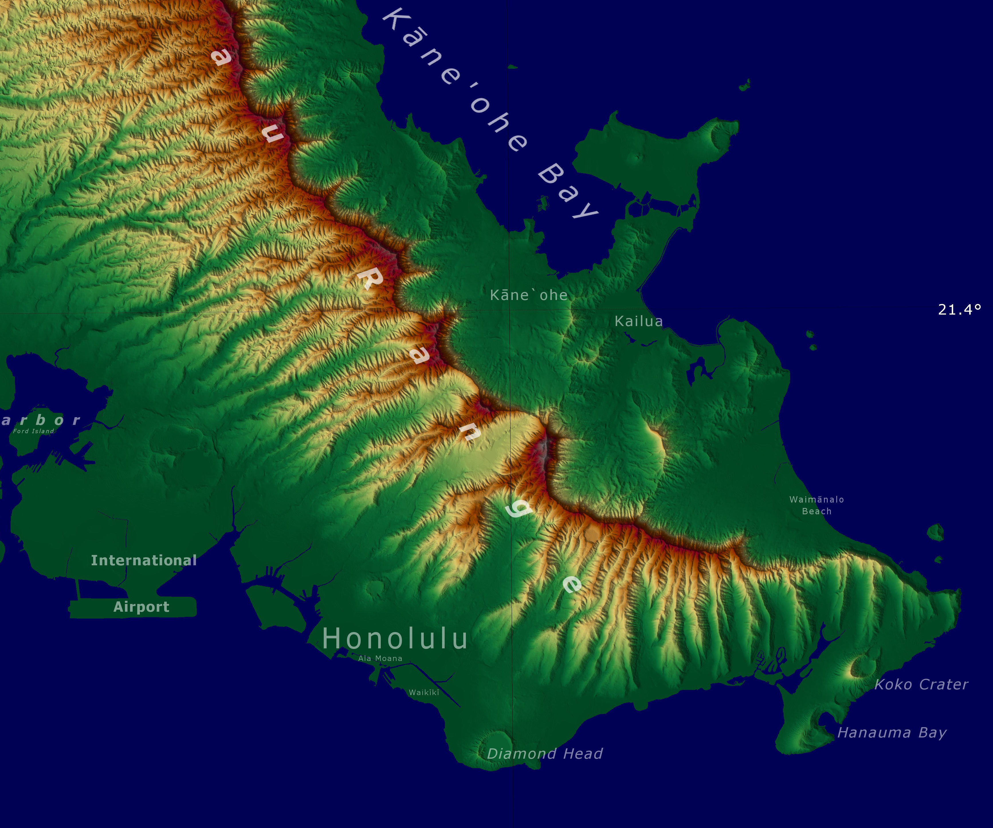
Oahu SRTM (cropped).JPG - Jo-Jo Eumerus

Pearl Lochs and Puuloa Entrance, 1873.jpg - Lkdaue

Ahupuaa of Oahu (4-color).svg - Mliu92

Admiralty Chart No 2294 Pearl River and Lochs From The United States Government Plan of 1899, Published 1901.jpg - Balkanique

Moku o Oahu.jpg - Coastaline

Moku o Oʻahu.jpg - Coastaline
Oahu Island Locator.jpg - Zoozaz1

Oahu Island.jpg - Zoozaz1

Hawaii Oahu-2-TF (Windward Viaduct).jpg - Krib

Map of internment sites on the island of O‘ahu.png - Alain Parks

Oahu ahupuaa.gif - KarlM

Honolulu Hawaii US street road map.svg - Kirill Shrayber