Wikimedi'Òc
Modes d'emploi

Cet album fait partie des albums
Cet album photos contient les sous-albums suivants :


Linguistic map of India, showing the areas where Indo-Aryan languages are spoken, published in the 'Imperial Gazetteer of India' (Vol. XXVI, Atlas; 1931 revised edition; plate no. 13).jpg - MaplesyrupSushi

Linguistic map of India, showing the areas where non-Indo-Aryan languages are spoken, published in the 'Imperial Gazetteer of India' (Vol. XXVI, Atlas; 1931 revised edition; plate no. 14).jpg - MaplesyrupSushi

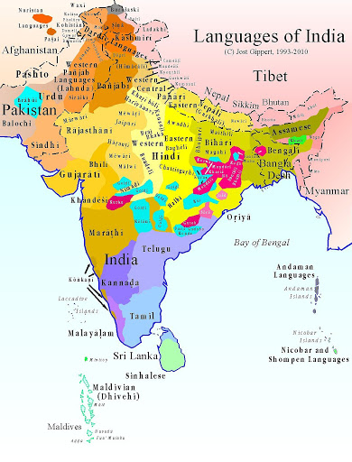
Langues de l'inde.png - AmbroiseL

South asia local.png - Apengu~commonswiki

States of South Asia 1.png - AnonyLog
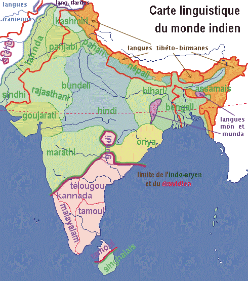
Monde indien langues.png - Spiridon Ion Cepleanu
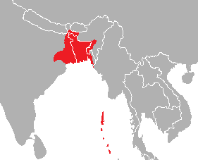
Location-Bangla01.png - Sbb1413

Indien Sprachfamilien.png - BishkekRocks

Taalgroepen in india.png - Renamed user 73876485f2f7c42af5f2a33994cf3cb0

Linguistic map of the Punjab Province, North-West Frontier Province, and princely-state of Jammu and Kashmir, British India, published in 'The Panjab, North-West Frontier Province and Kashmir' (1916).jpg - MaplesyrupSushi

Prevailing languages impgazind1909.jpg - Yann
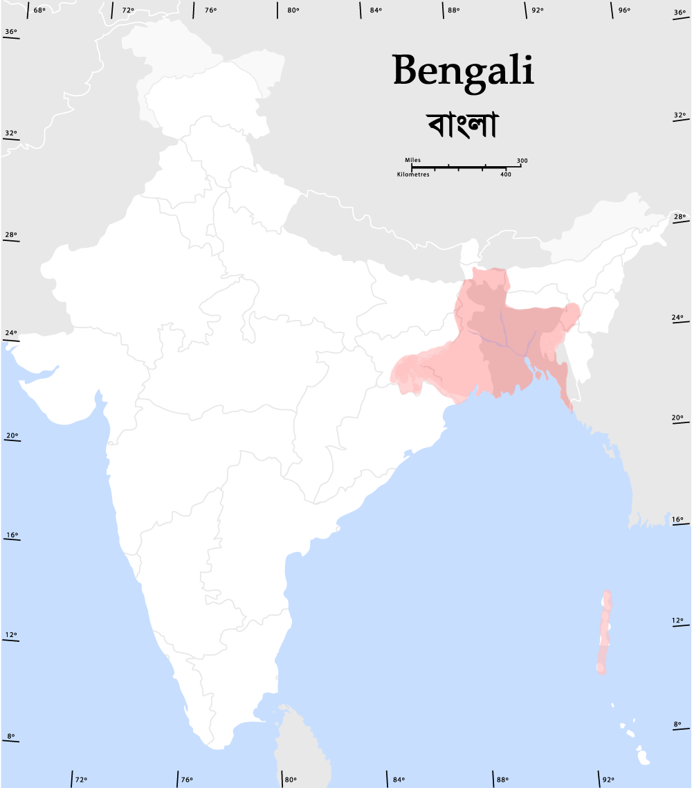
Bengali Verbreitung.png - File Upload Bot (Magnus Manske)

Uttarpradesh-languages.GIF - Faizhaider

Marathispeakers.png - Tonym88~commonswiki

Gujaratispeakers.png - Tonym88~commonswiki
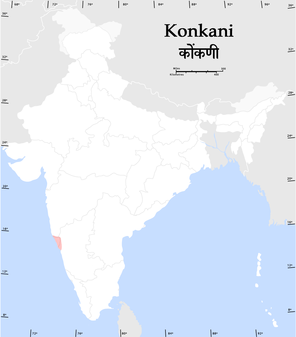
Konkanispeakers.png - Tonym88~commonswiki

States of South Asia new.png - Trinanjon

Tuluspeakers.PNG - ಶ್ರೀ
Bengalispeaking region.png - Trinanjon

KonLinguasphere.png - ImperiumCaelestis

India language map.jpg - Sreejithk2000

India-locator-language-map.png - Rajeshodayanchal

India, distribution of languages, 1893.jpg - Yann
States of South Asia.png - AntanO

Languages of SouthAsia (Tamil).png - AntanO

Lengas d'India.png - Nicolas Eynaud
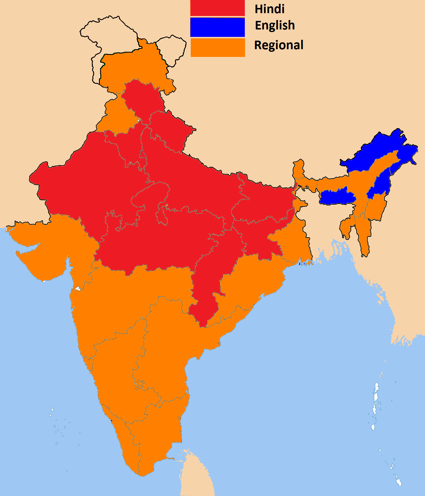
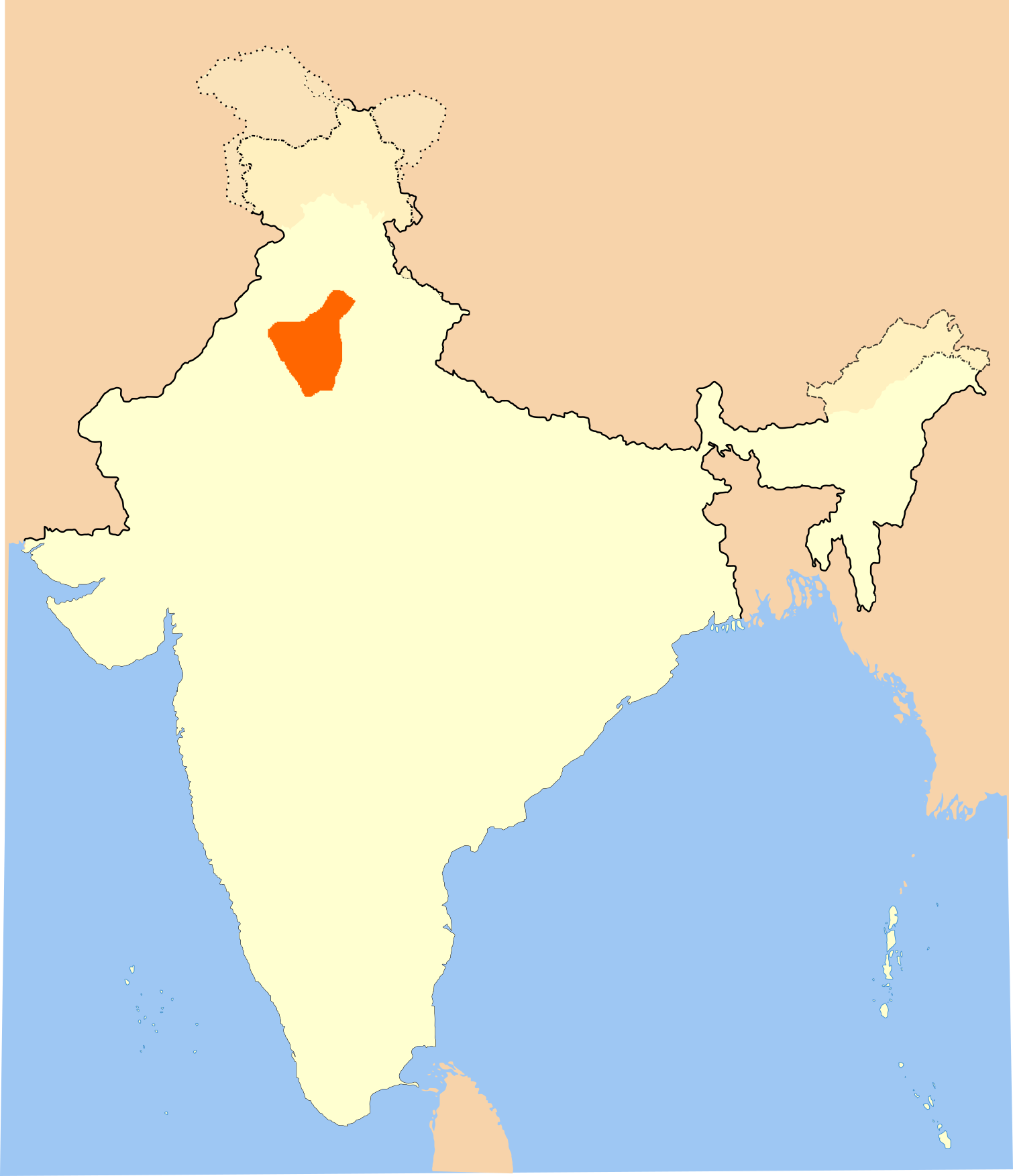
Indian states by official language.png - Wantsallanger

Languages of India (1859).jpg - Iaaasi

Südasien Sprachfamilien-ast.png - Munsterán

泰卢固人主要分布地.png - PyFishFish

Indika. The country and the people of India and Ceylon (1891) (14583573639).jpg - Fæ
Major Indo-Aryan languages.png - PadFoot2008
Bengali speaking zone.png - Vanished user ija0qfr2o3ijfi 4i4tijwci823irnf

A language map of India prepared for the missionary projects at Serampore, 1822.jpg - శ్రీధర్ బబు

Indian-languages-map.jpg - Koromandia

Language region maps of India (hy).png - O'micron

Tibetan Languages in India and Pakistan minor correction.jpg - Ladakh Bible
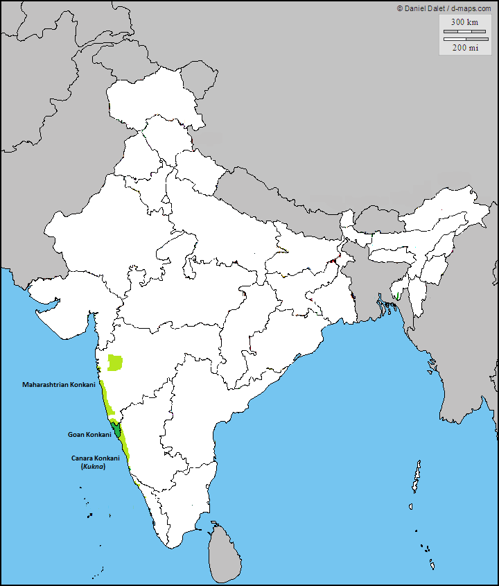
Geographic Distribution of Native Konkani Speakers.png - RobertBarathian

557 of 'Nouvelle Géographie universelle. La terre et les hommes. (With illustrations.)' (11115713293).jpg - Artix Kreiger 2

35 of 'A Phrenologist amongst the Todas; or the study of a primitive tribe in South India history, character, customs, religion, infanticide, polyandry, language ... illustrations by the autotype process' (11100931233).jpg - Artix Kreiger 2

441 of 'The Earth and its Inhabitants. The European section of the Universal Geography by E. Reclus. Edited by E. G. Ravenstein. Illustrated by ... engravings and maps' (11126852466).jpg - Artix Kreiger 2

Awadhi bhasha.png - Sattvic7

Historical geographical distribution of Sharada, borders.png - Sapedder

"Languages & Nations of India" and "Political Divisions of India"in 1858, 10 of 'From New York to Delhi, by way of Rio de Janeiro, Australia, and China' (11053770654) (cropped).jpg - User-duck

Prevailing Languages Imperial Gazetteer of India 1909.jpg - Fowler&fowler
Haryanvi map.png - C1MM
Gondi map.png - C1MM

Halbi map.png - C1MM

Bhili map.png - C1MM

Angika map.png - C1MM

Grasi new 17 (2).png - Prof RLMeena

South Indian script Burnell.png - Shyamal

"Hindi Speaking Population" India map in 1919 with the McMahon Treaty border detail, from- Foreign Missions Year Book of North America 1920 (Covering the year 1919) - (IA foreignmissionsy01fore) (page 111 crop).jpg - Tibet Nation
KaNordindien.png - Immanuel Giel
KaSuedindien.png - Immanuel Giel

Hindustani vs Deccani.png - Magichero1234
भरतखण्डे प्रचलिता भाषाः.jpg - 1940162 Hari chandana C

Languages of India.jpg - Tirengma

Madhya Pradesh bhoyari map betul .png - Bhartiya00

Map showing Distribution of Dravidian languages in 1913.jpg - SteinsplitterBot

Map Showing distribution of Dravidian languages in 1913.jpg - Enyavar

Indigenous languages that co-occur with the Western Ghats WHS.png - Semeai

Indigenous languages that co-occur with the Western Ghats WHS (cropped).png - Semeai

Rajasthani language.png - Ishq-e-zabaan

Kumaoni Language Speakers in India (2011 Census).png - Ishq-e-zabaan

Language region maps of India 2 two.jpg - Ultramanner

SouthAsiaLanguages.png - Tomislav Addai

Kudmali language region.svg - MaxA-Matrix

India lang 1973.jpg - Sbb1413

Linguistic map of East Chota Nagpur.jpg - MaxA-Matrix

Indian Languages Map.jpg - Haoreima

Ms-Languages-of-India-600w-01.jpg - Maris stella

Language Map India.png - Shyamal
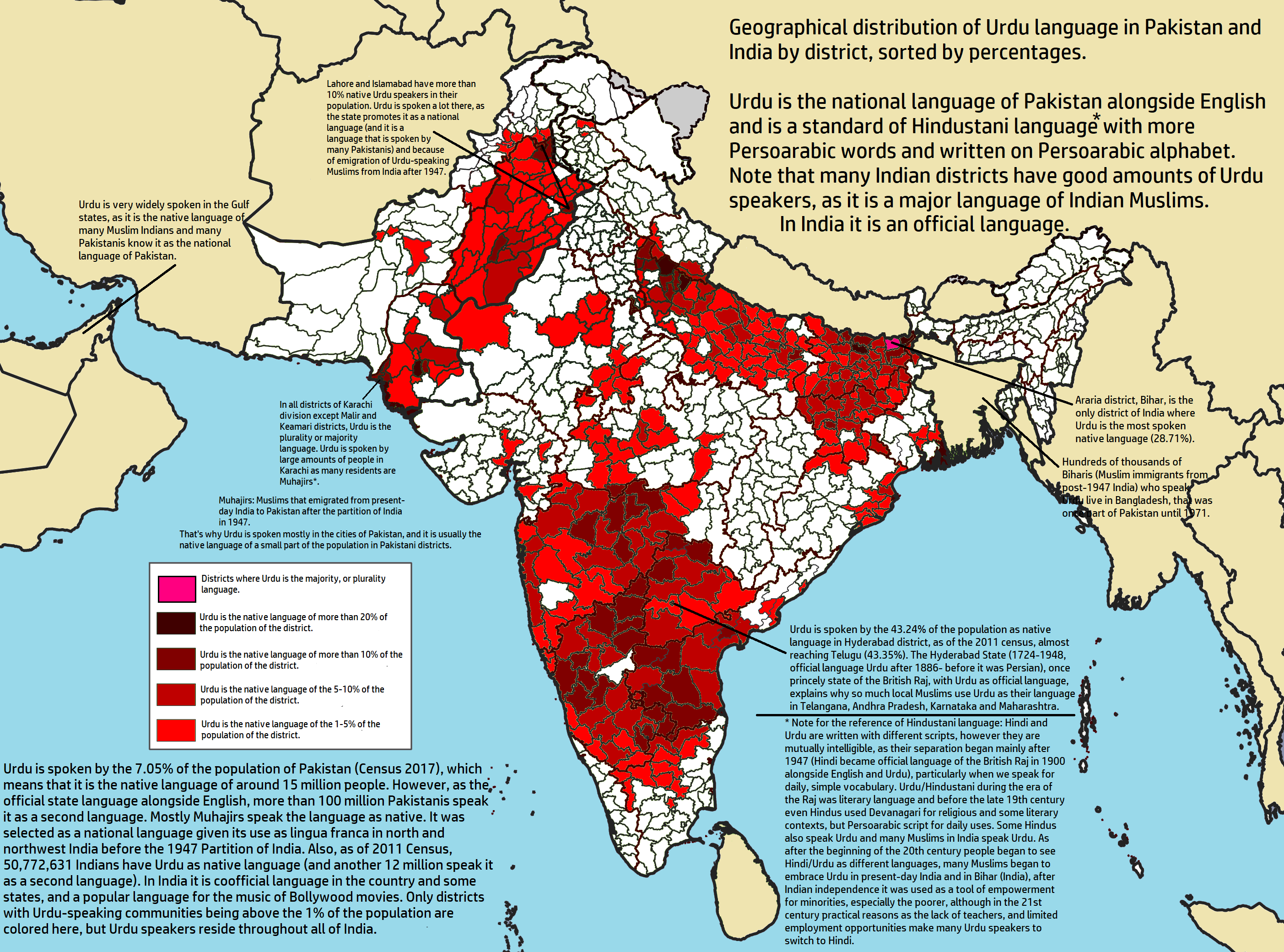
Geographical distribution of Urdu in India and Pakistan.png - NikosLikomitros

India Languages - DPLA - 893e20f862c87371733f8494b21da84f.jpg - DPLA bot

Lepcha language.png - Leo Euller

Sindhi dialect borders.png - Starkex

Map of India showing the distribution of langages - Beames 1868.jpg - Vis M

Map of the languages of North India - Hoernle 1880.png - Vis M

भारत के भाषा क्षेत्र मानचित्र.svg - Ashvin Kaitabhya

Dialects Of Punjabi~4.jpg - Khangan9590

Geographical distribution of Marwari language.jpg - Anshul Sharma 9B

Bhilispeakersmap.png - Skeletonwizard8

Sadri (Nagpuria) language distribution map.svg - MaxA-Matrix

Ho language distribution map.svg - MaxA-Matrix

Kannada language distribution.svg - Nyilvoskt

Malayalam language (ml, Q36236) distribution.svg - Nyilvoskt

Map of Assamese speaking regions in India.png - PadFoot2008

Linguistic map of India, titled "The Languages of India", published in the 'Baptist Magazine" (1859).jpg - MaplesyrupSushi

Language Map of Bihar (2011 Census).svg - WeaponizingArchitecture