Wikimedi'Òc
Modes d'emploi

Cet album fait partie des albums
Cet album photos contient les sous-albums suivants :


Ca-map.png - Wvl-live

Canada-CIA WFB Map.png - Wolfman~commonswiki

Toronto 1894large.jpg - Finavon
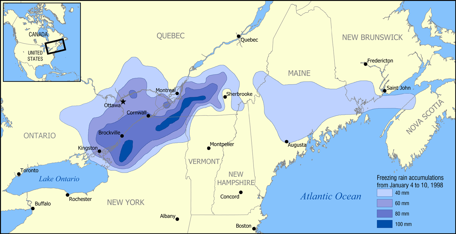
1998 Ice Storm map.png - NormanEinstein

UCM.png - Mortadelo2005

Map of Quebec.png - Leslie

Geopolitical map of Canada.png - Leonel Sohns

SaintJohn1894.jpg - Julo

Map of Louisbourg 1758.png - Nonenmac

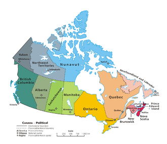
Political map of Canada.png - Andrew pmk~commonswiki
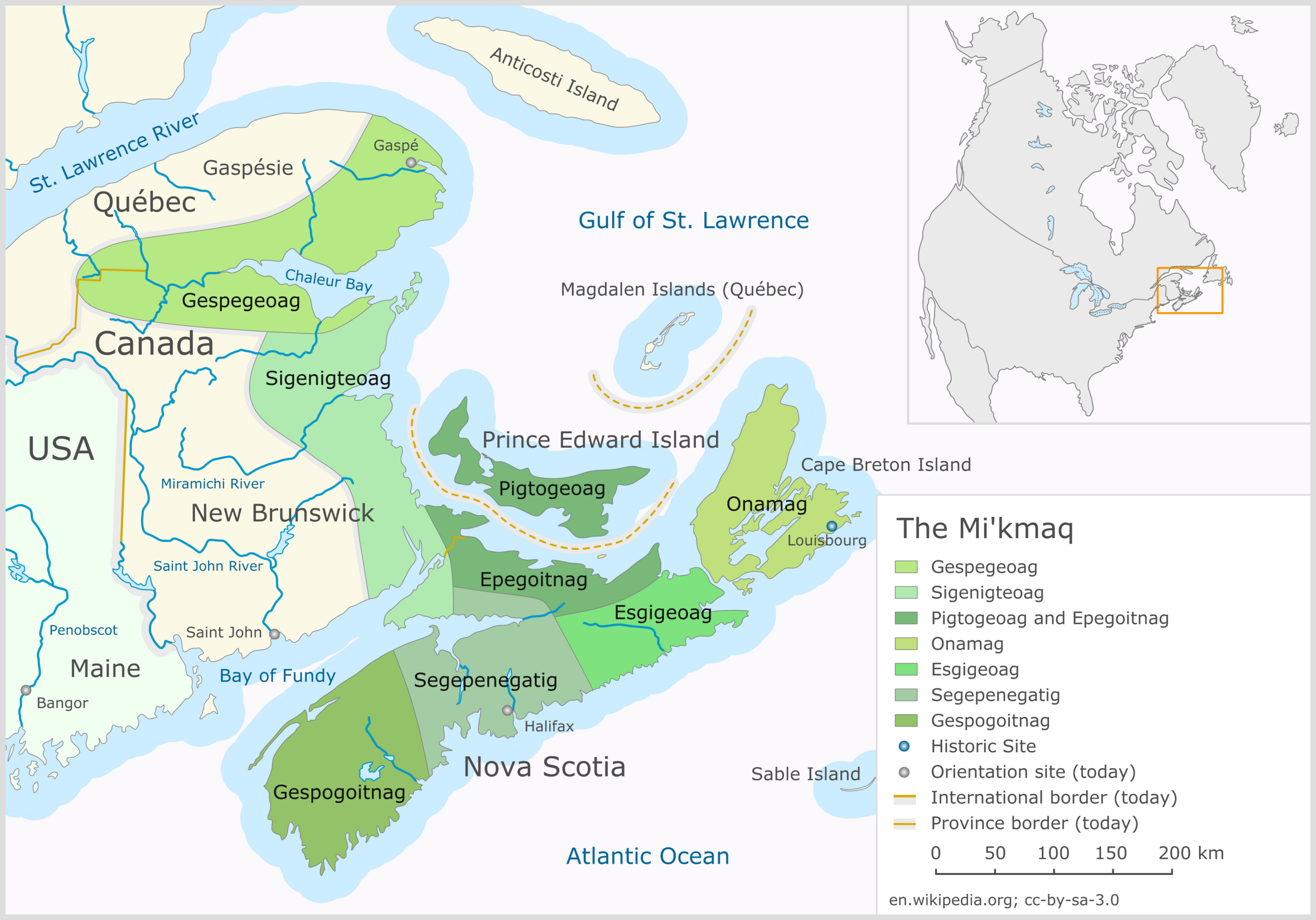
The Mi'kmaq.png - Mikmaq

NORTHWEST Angle.png - Fishal
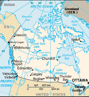
Hmap.jpg - Gump Stump

British Columbia 2006 population density.PNG - BetacommandBot

Maple Leaf boundaries.PNG - SimonP

Map Canada political 2.png - Merosonox~commonswiki

Canada Federal Election 2004-2011.gif - Rishiyur1

PanAm Games Locations.svg - Vidioman
2015panamvenues.jpg - Intoronto1125
Canada towns map east.png - GifTagger

Canada towns map trim 398 named.png - GifTagger
Canada towns map trim 398 unnamed.png - GifTagger

Canada towns map trim 430 named.png - GifTagger

Canada towns map trim 430 unnamed.png - GifTagger
Canada towns map west.png - GifTagger
Canada geol.jpg - Wikirictor

Wikivoyage Montreal district map.png - Ypsilon from Finland

Political map of Canada ms.svg - Goran tek-en

Eastern Canada electrical generating stations map, 1968.jpg - RA0808

Canada time zone map - en.svg - MapGrid

Political map of Canada.svg - Druiz002

Canada political map - en.svg - MapGrid

Canada Climate - DPLA - a3e8fccf029285230e51c3e948a039ec.jpg - DPLA bot

Canada drainage map - en.svg - MapGrid

Political map of Canada sr.png - CarRadovan

Laurie Fredonia or the United States of North America 1829 UTA.jpg - Michael Barera

CPC Endorsements (2022-11-04).png - TheEpicGhosty

The Dominion of Canada, a reduction of the map prepared and issued under the direction of the minister of railways and canals. 1882 - btv1b53022803w.jpg - Gzen92Bot

Mineral map of the Dominion of Canada - btv1b53209827v.jpg - Gzen92Bot

Map showing the general northern limits of the principal forest trees of the Dominion of Canada - by Robert Bell... - btv1b53121533x.jpg - Gzen92Bot

A". The Labrador Peninsula - btv1b53200590c.jpg - Gzen92Bot

Map of the Dominiom of Canada ... - Topographical surveys branch - btv1b53198376r.jpg - Gzen92Bot

Canada Map 3 - Terrain - DPLA - 9d3a2bcd16e310769d57247c939b852b.jpg - DPLA bot

Canada - DPLA - 76571277b6e47577dabd38f2e5e527dd.jpg - DPLA bot

Canada (Maps 6,7,8,9,10,11,16,17) - DPLA - c8c22580a8b6b4a06f327c8116c49cb9.jpg - DPLA bot

Canada - DPLA - 157b8492b18185ece1a2347334e8c24a.jpg - DPLA bot

Canada - DPLA - 79fd612551836475b3a9af7d1c3a4b50.jpg - DPLA bot

Canada - DPLA - a1377b0f9499e05df9ebb223f9b83144.jpg - DPLA bot

ECHO Canada Editable A4 Landscape.png - OptimusPrimeBot