Wikimedi'Òc
Modes d'emploi

Cet album fait partie des albums
Cet album photos contient les sous-albums suivants :


1806 Cary Map of Asia, Polynesia, and Australia - Geographicus - Asia-cary-1806.jpg - BotMultichillT

The physical atlas - a series of maps & notes illustrating the geographical distribution of natural phenomena LOC 2007627199-31.jpg - Fæ

Oceanie ou Australasie et Polynesie - -par- Lapie - gravée par J.A. Caneria à Amsterdam - UvA-BC OTM HB-KZL 69 11 04.jpg - Spinster
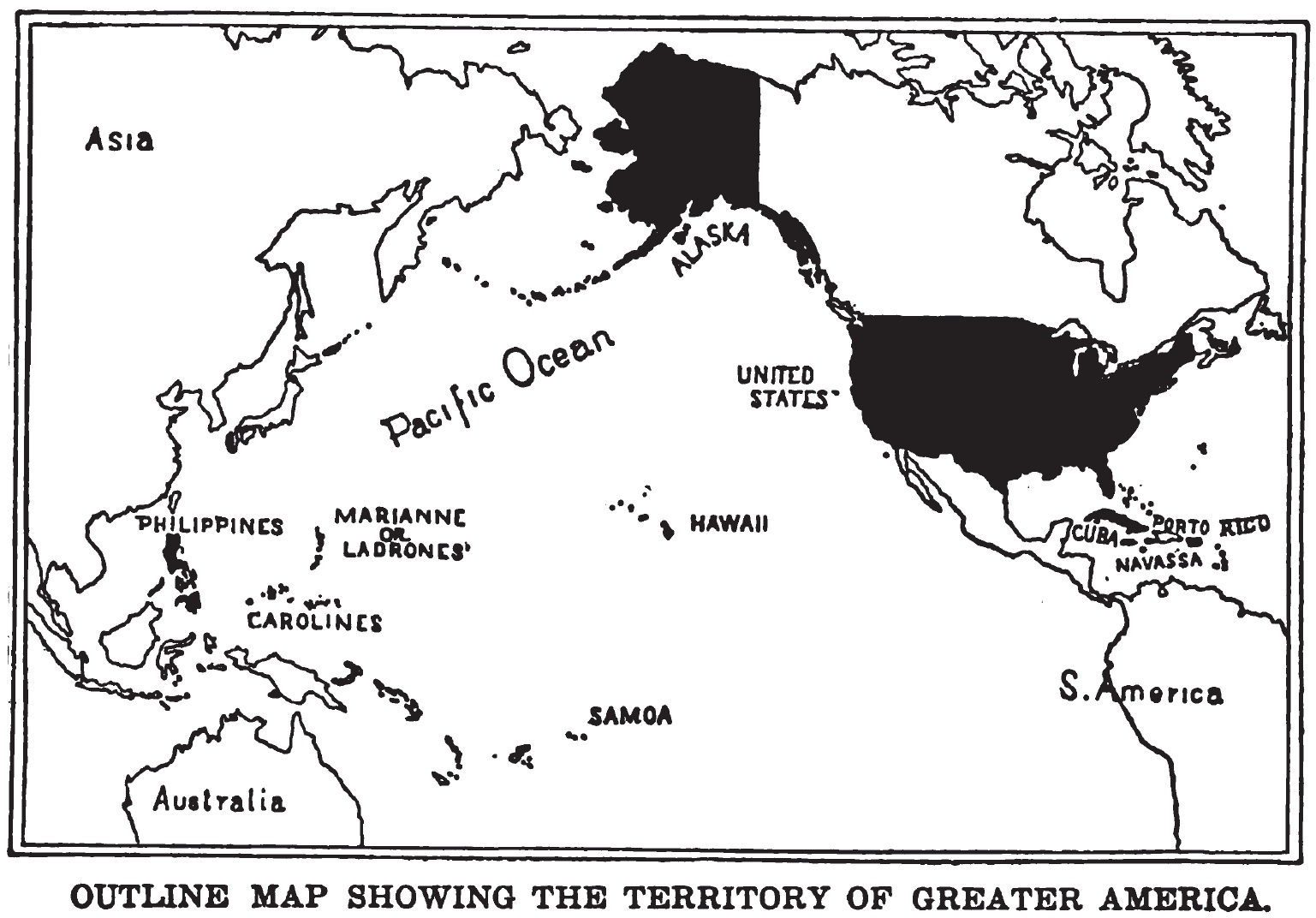
GreaterAmericaMap.jpg - Quazgaa
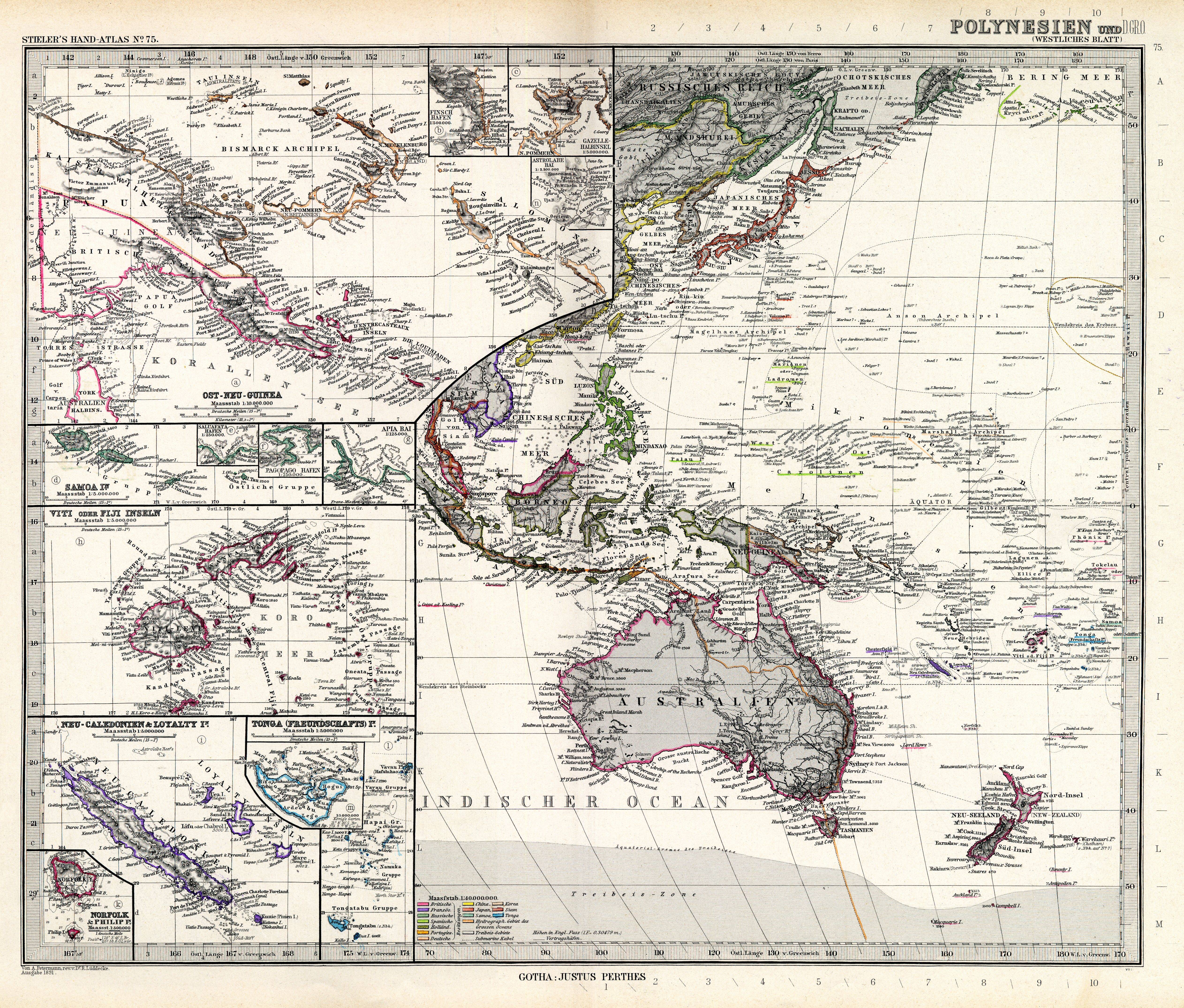
Stielers Handatlas 1891 75.jpg - Kolossos

1874 Mitchell Map of Australia, Polynesia and Hawaii - Geographicus - Polynesia-m-1874.jpg - BotMultichill

1852 Bocage Map of Australia and Polynesia - Geographicus - Oceanie-bocage-1852.jpg - BotMultichillT

1855 U.S.C.S. Map of the Western Coast of the United States - Geographicus - WesternCoast-uscs-1855.jpg - BotMultichillT

1855 Spruner Map of Australia and Polynesia with an overview of Discoveries and Colonization - Geographicus - AustraliaPolynesia-spruner-1855.jpg - BotMultichillT

First Voyage Round The World Pacific.jpg - Keith Edkins

HEINZELMANN(1851) 06.955 Kartenblatt Australien und Ozeanien.jpg - Metilsteiner

(1899) MAP OF OCEANIA - comp. by Irvine.jpg - Metilsteiner

A cyclopedia of missions - containing a comprehensive view of missionary operations throughout the world - with geographical descriptions, and accounts of the social, moral, and religious condition of (14576608028).jpg - Fæ

Brockhaus' Konversations-Lexikon (1892) (14761497946).jpg - Fæ

Bulletin de la Société de Géographie (1832) (20245290268).jpg - Fæ

Meyers b4 s0573 b1.png - Mapmarks

Hero tales of the American soldier and sailor as told by the heroes themselves and their comrades; the unwritten history of American chivalry (1899) (14783940895).jpg - Fæ

A new universal atlas of the world - on an improved plan; consisting of thirty maps, carefully prepared from the latest authorities; with complete alphabetical indexes (1825) (14595350808).jpg - SteinsplitterBot

Humboldt; Monatsschrift für die gesamten Naturwissenschaften (1882) (14593431028).jpg - SteinsplitterBot

An illustrated history of our war with Spain - its causes, incidents, and results (1898) (14579469259).jpg - SteinsplitterBot

The geography of mammals (1899) (14579549387).jpg - Fæ

A cyclopedia of missions - containing a comprehensive view of missionary operations throughout the world - with geographical descriptions, and accounts of the social, moral, and religious condition of (14576557710).jpg - SteinsplitterBot

Image taken from page 437 of 'Südsee-Bilder ... Mit 26 Tafeln und 2 Karten' (16590127425).jpg - Artix Kreiger 2

Image taken from page 437 of 'Südsee-Bilder ... Mit 26 Tafeln und 2 Karten' (11232686994).jpg - Artix Kreiger 2

93 of 'Chambers's Alternative Geography Readers. Standard IV.(-VII.)' (11292336046).jpg - Artix Kreiger 2

151 of 'Le Globe illustré. Géographie générale à l'usage des écoles et des familles ... Ouvrage illustré de nombreuses gravures intercalées dans le texte et accompagné de 16 cartes tirées en couleur' (11098170935).jpg - SteinsplitterBot

178 of 'Geographie Générale ... Avec index, etc' (11099225704).jpg - Artix Kreiger 2

87 of 'Viaggio interno al globo della R. pirocorvetta italiana Magenta, negli anni 1865-66-67-68. ... Relazione descrittiva e scientifica. ... Con una introduzione etnologica di P. Mantegazza' (11101122886).jpg - Artix Kreiger 2

7 of 'Viaggio interno al globo della R. pirocorvetta italiana Magenta, negli anni 1865-66-67-68. ... Relazione descrittiva e scientifica. ... Con una introduzione etnologica di P. Mantegazza' (11102614503).jpg - Artix Kreiger 2

115 of 'Viaggio interno al globo della R. pirocorvetta italiana Magenta, negli anni 1865-66-67-68. ... Relazione descrittiva e scientifica. ... Con una introduzione etnologica di P. Mantegazza' (11098707825).jpg - Artix Kreiger 2

20 of 'Stanford's Compendium of Geography and Travel ... Australasia. Edited and extended by A. R. Wallace ... With ethnological appendix by A. H. Keane ... Fifth edition' (11194744104).jpg - FlickreviewR 2

31 of 'Atlas' (11013217836).jpg - SteinsplitterBot
16 of 'Comparative Physical Geography; or the earth in relation to man ... Translated from the French by C. C. Felton, etc' (11034351475).jpg - Artix Kreiger 2

14 of 'Captain Cook- his life, voyages, and discoveries. (With illustrations.)' (11093772166).jpg - Artix Kreiger 2

15 of 'Captain Cook- his life, voyages, and discoveries. (With illustrations.)' (11094964023).jpg - Artix Kreiger 2

1041 of 'La Terra, trattato popolare di geografia universale per G. Marinelli ed altri scienziati italiani, etc. (With illustrations and maps.)' (11246999495).jpg - Artix Kreiger 2

1040 of 'La Terra, trattato popolare di geografia universale per G. Marinelli ed altri scienziati italiani, etc. (With illustrations and maps.)' (11248669674).jpg - Artix Kreiger 2

1197 of 'La Terra, trattato popolare di geografia universale per G. Marinelli ed altri scienziati italiani, etc. (With illustrations and maps.)' (11246112264).jpg - Artix Kreiger 2

87 of '(The India Directory, for the guidance of commanders of steamers and sailing vessels. Founded upon the work of ... J. Horsburgh ... By ... A. D. Taylor. pt. 1.)' (11212738863).jpg - Artix Kreiger 2

717 of '(The India Directory, for the guidance of commanders of steamers and sailing vessels. Founded upon the work of ... J. Horsburgh ... By ... A. D. Taylor. pt. 1.)' (11209227145).jpg - Artix Kreiger 2

45 of 'In Journeyings Oft. A sketch of the life and travels of Mary C. Nind' (11145933493).jpg - Artix Kreiger 2

341 of 'A Lady's Cruise in a French Man-of-War ... With map and illustrations' (11159283634).jpg - Artix Kreiger 2

14 of 'L'enseignement pratique de la géographie. Atlas, cartes, textes & questionnaires ... Cours móyen' (11124184856).jpg - Artix Kreiger 2

257 of 'The British Empire- its geography, resources, commerce, land-ways and water-ways' (11209262115).jpg - Artix Kreiger 2

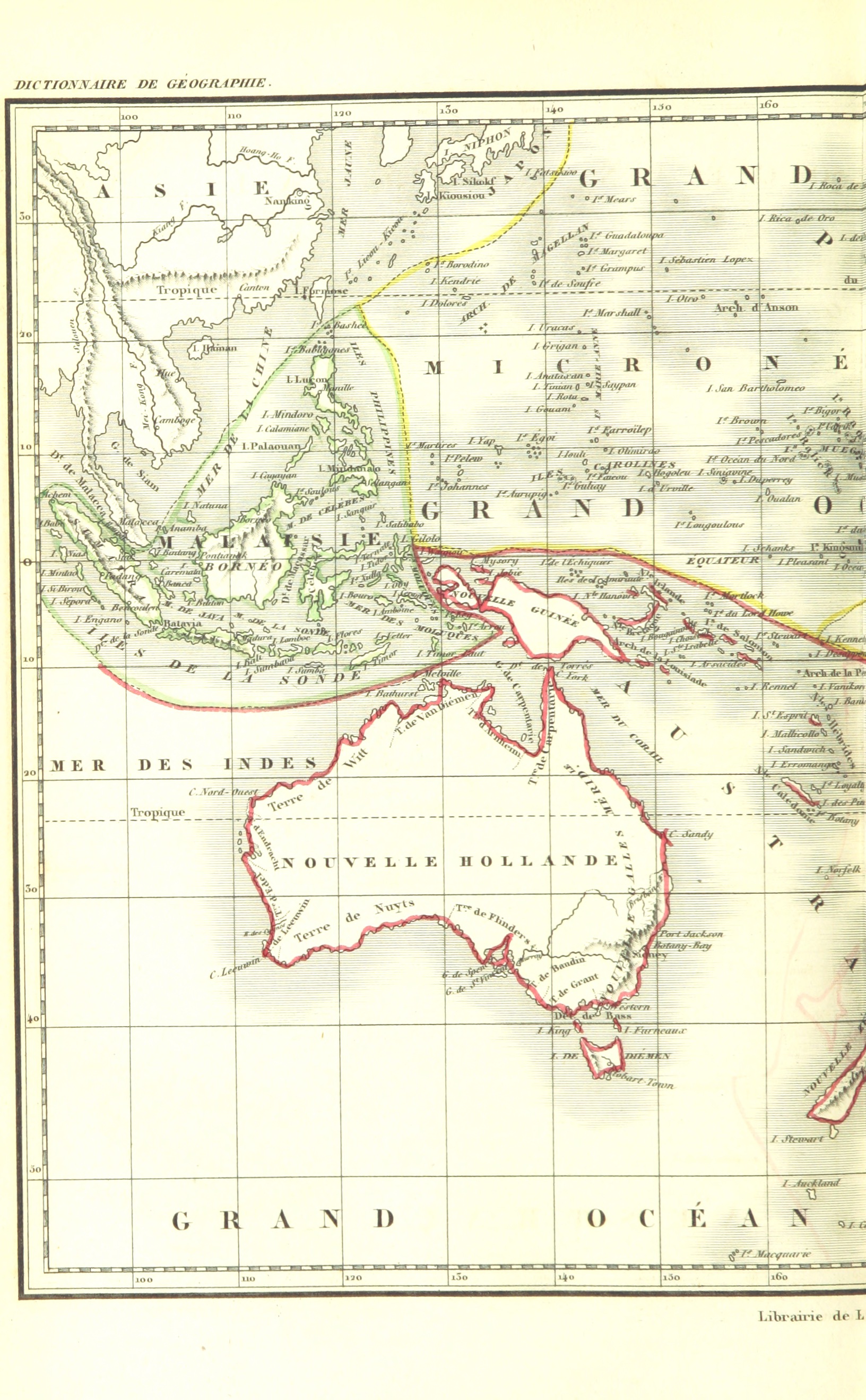
103 of 'Dictionnaire de Géographie ancienne et moderne' (11026841264).jpg - Artix Kreiger 2
706 of 'Dictionnaire de Géographie ancienne et moderne' (11027412286).jpg - Artix Kreiger 2

707 of 'Dictionnaire de Géographie ancienne et moderne' (11026569336).jpg - Artix Kreiger 2

674 of 'The International Geography. ... Edited by H. R. Mill' (11167175553).jpg - Artix Kreiger 2
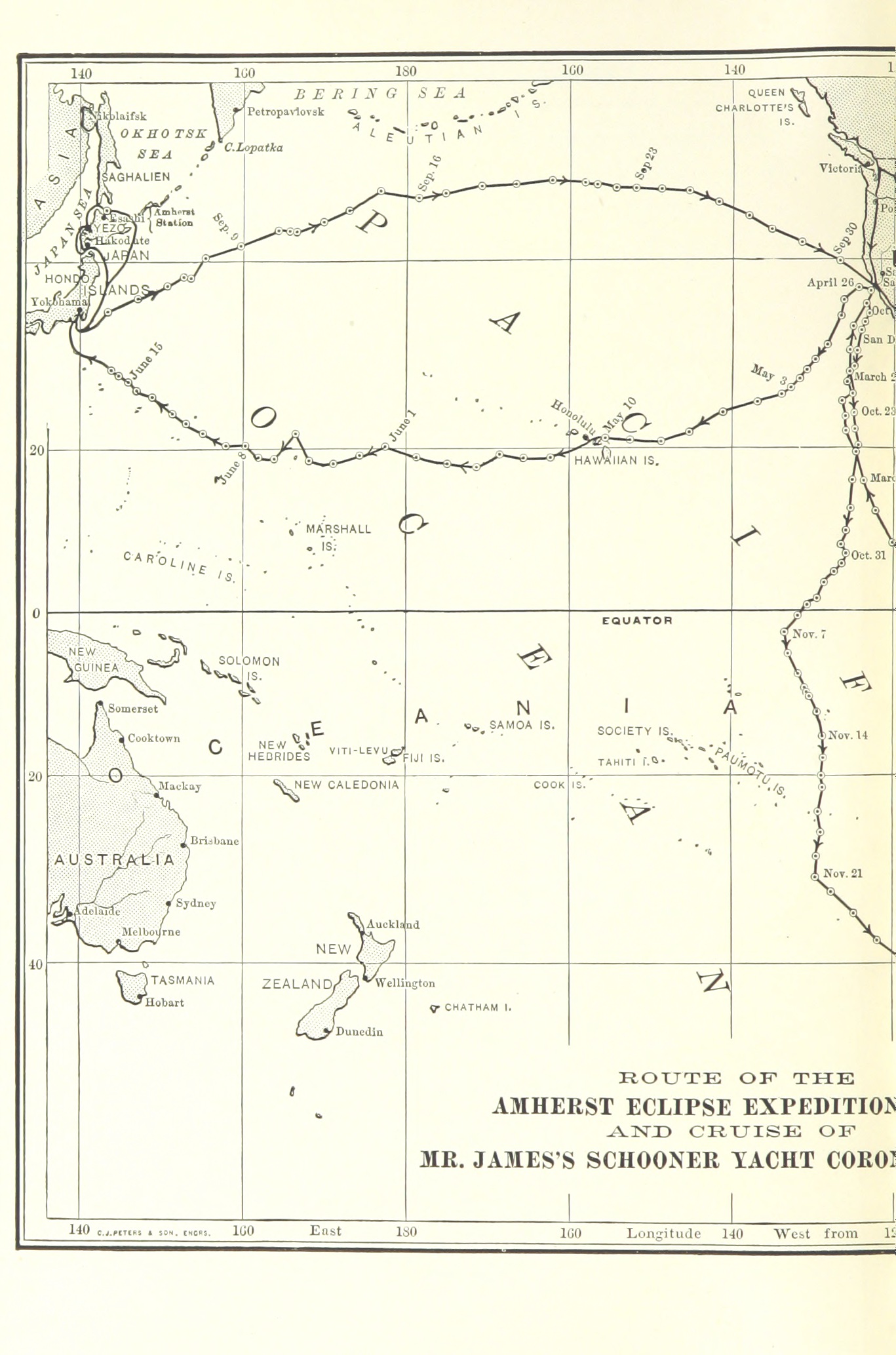
Image taken from page 464 of 'Corona and Coronet. Being a narrative of the Amherst Eclipse expedition to Japan, in Mr. James's schooner-yacht Coronet, to observe the sun's total obscuration, 9th August, 1896' (11247232733).jpg - Artix Kreiger 2
224 of 'General Examination of the Pacific Ocean ... Followed by nautical directions for avoiding hurricanes. Translated from the second French edition, under the direction of Commander C. H. Davis' (11075471766).jpg - Artix Kreiger 2
225 of 'General Examination of the Pacific Ocean ... Followed by nautical directions for avoiding hurricanes. Translated from the second French edition, under the direction of Commander C. H. Davis' (11075851426).jpg - Artix Kreiger 2
227 of 'General Examination of the Pacific Ocean ... Followed by nautical directions for avoiding hurricanes. Translated from the second French edition, under the direction of Commander C. H. Davis' (11083624203).jpg - Artix Kreiger 2

214 of 'Les Polynésiens et leurs migrations ... Ouvrage accompagné de 4 cartes gravées' (11072937143).jpg - Artix Kreiger 2
215 of 'Les Polynésiens et leurs migrations ... Ouvrage accompagné de 4 cartes gravées' (11071570266).jpg - Artix Kreiger 2

448 of 'A Class-Book of Modern Geography ... New edition, revised and largely rewritten (by Albert Hill), etc' (11150561464).jpg - Artix Kreiger 2

341 of 'The Philippine Islands ... Illustrated' (11252172474).jpg - Artix Kreiger 2

191 of 'The “Beaumont” Geography and Map Tracing Book' (11247416395).jpg - SteinsplitterBot

20 of 'Ten Months in the Fiji Islands ... With an introduction and appendix by ... W. J. Smythe. Illustrated by chromolithographs and woodcuts ... With maps by Arrowsmith' (11065527545).jpg - Artix Kreiger 2

Australien und Polynesien in Mercators Projection.jpg - Higgenhorscht
Chart of the Pacific Ocean. LOC 98687129.tif - Fæ

Chart of the Pacific Ocean. LOC 98687129.jpg - Fæ

Admiralty Chart No 780 Pacific Ocean in four sheets SW, Published 1875.jpg - Kognos

Admiralty Chart No 782 Pacific Ocean in four sheets NE, Published 1875.jpg - Kognos

Admiralty Chart No 783 Pacific Ocean in four sheets SE, Published 1875.jpg - Kognos

Admiralty Chart No 788 South Pacific Ocean Western Sheet, Published 1877.jpg - Kognos

Admiralty Chart No 789 South Pacific Ocean Eastern Sheet, Published 1877.jpg - Kognos

Admiralty Chart No 987 Plans of Islands in the South Pacific, Published 1873.jpg - Kognos

Admiralty Chart No 1936 Islands in the North Pacific Ocean, Published 1849.jpg - Kognos

Admiralty Chart No 2683 Pacific Ocean, Published 1887.jpg - Kognos

Admiralty Chart No 781 Pacific Ocean (In Four Sheets) N.W. Sheet, Published 1875, Corrections to 1933.jpg - Balkanique

Admiralty Chart No 2468 Pacific Ocean. Sheet 10, Norfolk Id. to 65°S, Published 1856.jpg - Kognos
Admiralty Chart No 2683 Pacific Ocean, Published 1859.jpg - Kognos
Admiralty Chart No 2463 Pacific Ocean Chusan Islands to Shark Bay, Western Australia, Published 1857.jpg - Kognos

Chart of the Northern Passage Between Asia & America.jpg - Balkanique

Admiralty Chart No 787 Cape Corrientes, Mexico to Kadiak Island Compiled from the most recent Surveys in the Hydrographic Office, 1876, Published 1877.jpg - Balkanique

Meyer‘s Zeitungsatlas 042 – Der grosse Ocean und Australien.jpg - Derbrauni

A Modern Buccaneer - Map.png - Sp1nd01

Carte de l'Océanie. dressée par Pierre Tardieu - btv1b530986827.jpg - Gzen92Bot

Budapest tervrajza (1 - 14.000 environ) - Posner K. L. - btv1b8459719r (2 of 2).jpg - Gzen92Bot

Balls Pyramid, South Pacific Denham 1853 Nla.obj-231291098.jpg - Kognos

North-Pacific Ocean - btv1b53029194t.jpg - Gzen92Bot

Carte de l'Océanie - dressée par Pierre Tardieu - btv1b530351956.jpg - Gzen92Bot

КАРТА МОРСКИХЪ ОТКРЫТІЙ РОССІЙСКИМИ МОРЕПЛАВАТЕЛЯМИ НА ТИХОМЪ И ЛЕДОВИТОМЪ МОРЯХЪ - ВЪ РАЗНЫХЪ ТОДАХЪ УЧИНЕННЫХЪ... - btv1b53089863n.jpg - Gzen92Bot
Nuova carta dell'Oceania.jpg - Vilma.bono

Meyers leiner Hand-atlas 1893 (73137807).jpg - Enyavar

Admiralty Chart No 215 New Caledonia Kunie Island to New Zealand North Cape, Published 1898, New Edition 1963.jpg - Kognos