Wikimedi'Òc
Modes d'emploi

Cet album fait partie des albums
Cet album photos contient les sous-albums suivants :


Dugdale's Visitation of Yorkshire, with additions (IA dugdalesvisitati03dugd 0).pdf - Fæ

KTombDugdale67.jpg - Kaba
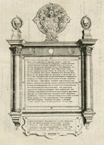
Tomb John of Gaunt and Blanche of Lancaster.jpg - Evening.star

Wenceslas Hollar - William Dugdale (State 5).jpg - Dcoetzee

Wenceslas Hollar - William Dugdale (State 5) cropped.jpg - Dcoetzee

Sir William Dugdale from NPG.jpg - Dcoetzee

Portrait of Sir William Dugdale by Sylvester Harding.jpg - MarmadukePercy

Tomb slab of John Mullins and memorial to Sir Simon Baskerville in St Paul's by Wenceslaus Hollar.jpg - MarmadukePercy

Dugdale sketch 1634 Detail.jpg - Tom Reedy

WTC Andy Mabbett DSC 6325.JPG - File Upload Bot (Kaldari)

Manual of British topography, a catalogue of county and local histories, pamphlets, views, drawings, maps, etc. connected with and illustrating the principal localities in the United Kingdom (1909) (14780498944).jpg - Fæ
George Abbott tablet.jpg - Charles Matthews

A small specimen of the many mistakes in Sir William Dugdale's Baronage Fleuron T100036-2.png - Fæ

Heraldic miscellanies, consisting of the lives of Sir William Dugdale, Garter and Gregory King, Esq Fleuron N001118-2.png - Fæ

William Dugdale MET DP823419.jpg - Pharos

Arms of Sir William Dugdale.svg - Sodacan

OdingsellsArms LongItchingtonChurch ByDugdale 1656.png - Lobsterthermidor

Drawing of the Shrine of Little St Hugh, Lincoln Cathedral, William Dugdale, 1641.png - Tenpop421

Dugdale's "Imbanking and Drayning', title page.jpg - Ttocserp

Map of the Ancholme Valley (c. 1640).jpg - Ittybittykittycommittee

The Map of Deeping Fenne (c.1662).jpg - Ittybittykittycommittee

A Map of East and West Fenne (c. 1662).jpg - Ittybittykittycommittee

"A Map of the Great Levell, representing it as it lay drowned." (1662).jpg - Ittybittykittycommittee
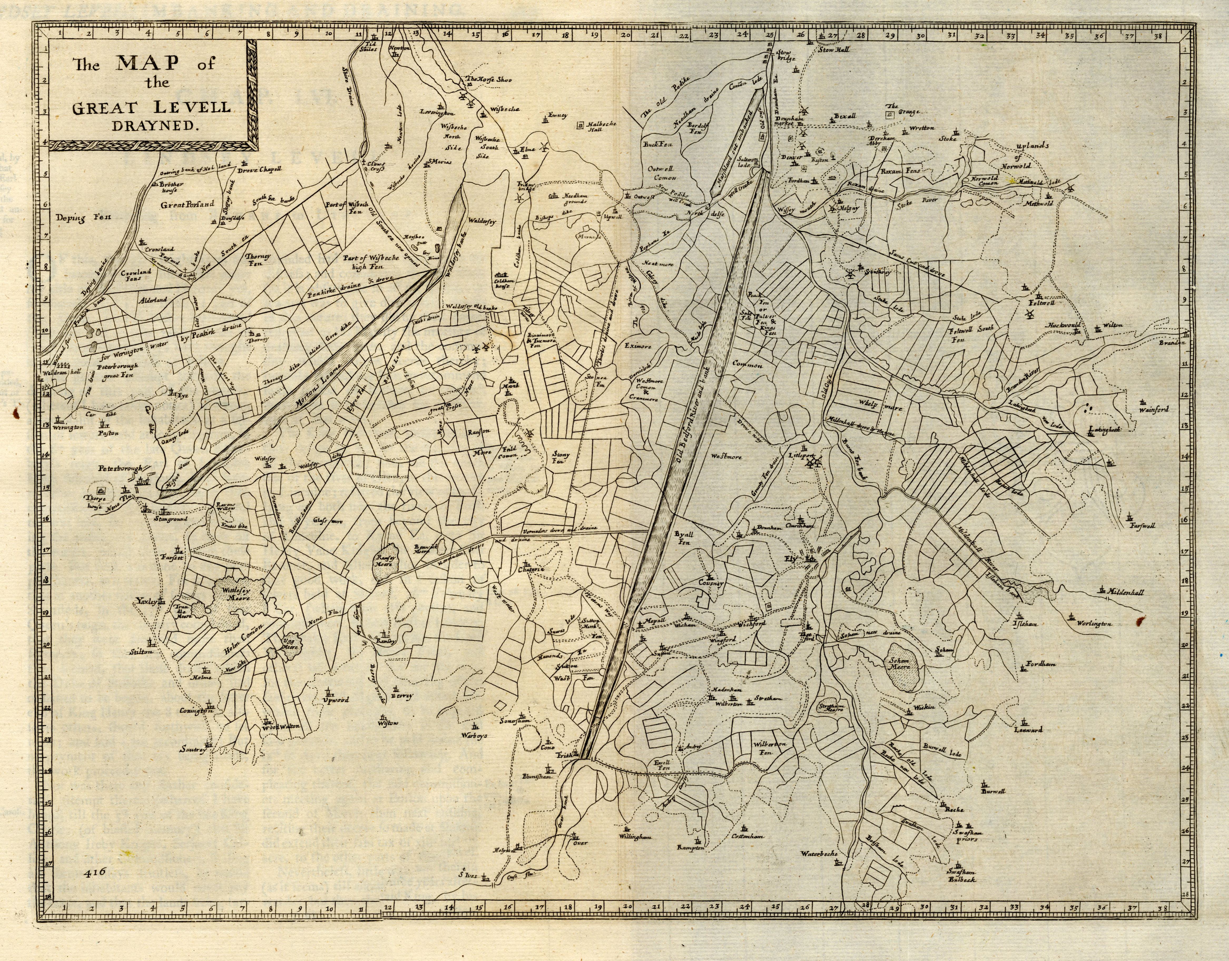
"The Map of the Great Levell drained" (1662).jpg - Ittybittykittycommittee

"A true and perfect Plot of Hatfield Chase, in the Counties of York, Lincoln, and Nottingham as surveyed by Josias Acerlebout." (1662).jpg - Ittybittykittycommittee

"The Map of Lindsey Level" (1662).jpg - Ittybittykittycommittee

"The Map of the marshland in Norfolk".jpg - Ittybittykittycommittee
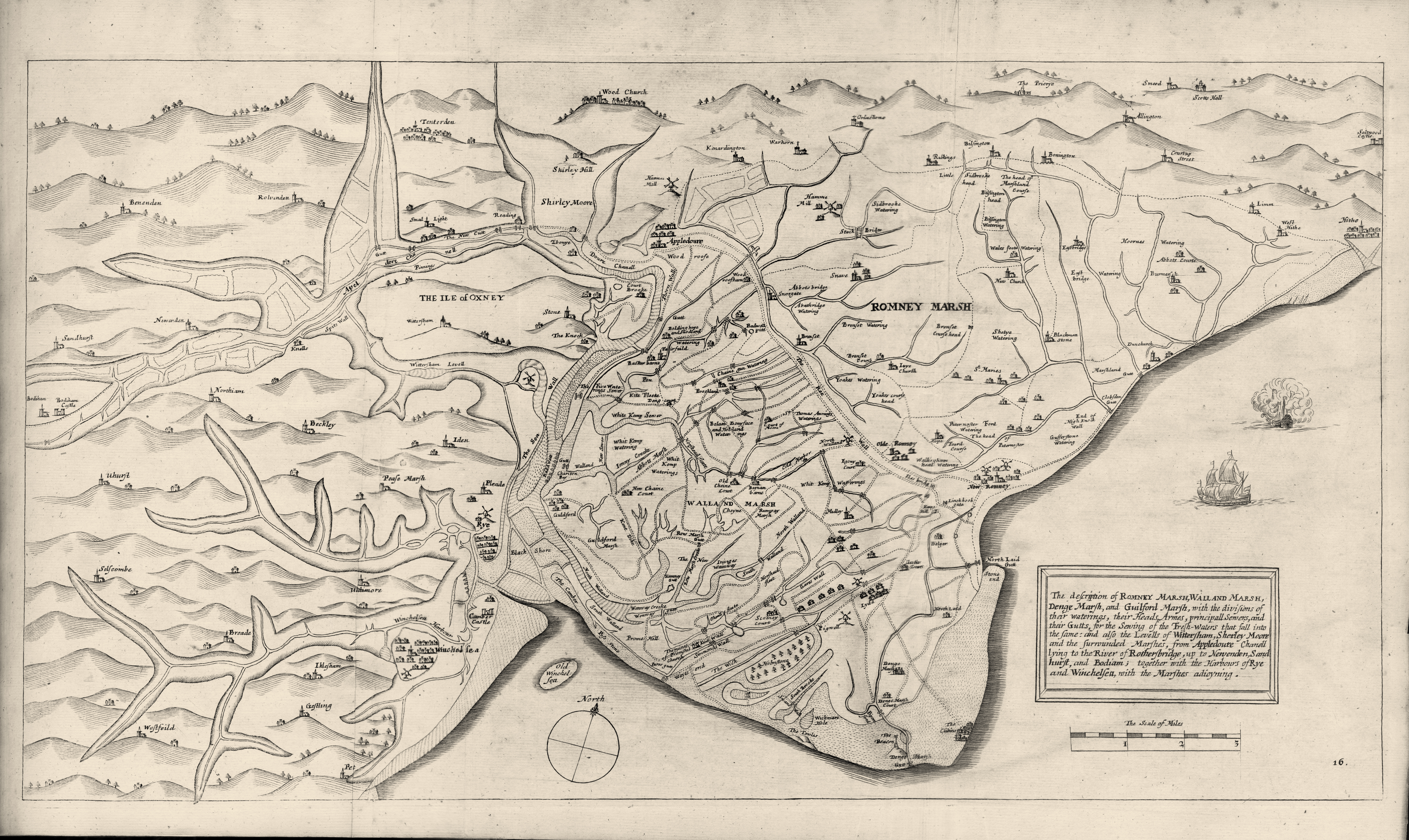
A map of Romney Marsh (1662).jpg - Ittybittykittycommittee

The Map of Sedgemoor, with adjacent Parts (1662).jpg - Ittybittykittycommittee

The Map of South Holland (1662).jpg - Ittybittykittycommittee

Shrine of Little St Hugh of Lincoln.png - JimKillock