Wikimedi'Òc
Modes d'emploi

Cet album fait partie des albums
Cet album photos contient les sous-albums suivants :


Map of Rhode Island highlighting Washington County.svg - Nux

USA Washington County, Rhode Island age pyramid.svg - DieBucheBot

Highest point in Washington County, Rhode Island.jpg - Daniel Case
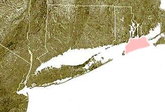
Wpdms ev26188 rhodeislandsound.jpg - Urdangaray
Exterior detail of connector and boiler room (Constructed after 1953); Connector links east wing (Known as A-130 prior to 1953) and west wing (Known as A-129 prior to 1953) - HABS RI,5-DAVIL.V,1A-5.tif - Fæ
Detail of door at east side of east wing - Advance Base Depot, Davisville, Building A-130, Northeast section of Advance Base Depot, adjacent to Pier No. 1, Davisville, HABS RI,5-DAVIL.V,1A-4.tif - Fæ
Detail of dormer window at east wing; provides ventilation and natural light - Advance Base Depot, Davisville, Building A-130, Northeast section of Advance Base Depot, adjacent HABS RI,5-DAVIL.V,1A-3.tif - Fæ
Detail of windows at southeast corner of T-17 - Advance Base Depot Davisville, Building T-17, Ninth Street southeast of Davisville Road, Davisville, Washington County, RI HABS RI,5-DAVIL.V,1B-4.tif - Fæ
Detail of steel bracing above the doors at west end, T-17 - Advance Base Depot Davisville, Building T-17, Ninth Street southeast of Davisville Road, Davisville, Washington HABS RI,5-DAVIL.V,1B-10.tif - Fæ
Detail of vent stack, T-18 - Advance Base Depot Davisville, Building T-17, Ninth Street southeast of Davisville Road, Davisville, Washington County, RI HABS RI,5-DAVIL.V,1B-15.tif - Fæ
Detail of steel ribs of T-18, showing connectin to concrete foundation wall - Advance Base Depot Davisville, Building T-17, Ninth Street southeast of Davisville Road, HABS RI,5-DAVIL.V,1B-13.tif - Fæ
Detail of cross bracing at east end, T-18 - Advance Base Depot Davisville, Building T-17, Ninth Street southeast of Davisville Road, Davisville, Washington County, RI HABS RI,5-DAVIL.V,1B-17.tif - Fæ
Detail showing cross bracing at east end, T-18 - Advance Base Depot Davisville, Building T-17, Ninth Street southeast of Davisville Road, Davisville, Washington County, RI HABS RI,5-DAVIL.V,1B-16.tif - Fæ
Detail of steel ribs at north wall, T-18 - Advance Base Depot Davisville, Building T-17, Ninth Street southeast of Davisville Road, Davisville, Washington County, RI HABS RI,5-DAVIL.V,1B-20.tif - Fæ
Detail at southwest corner, T-18, showing steel studs and ribs and corrugated metal cladding - Advance Base Depot Davisville, Building T-17, Ninth Street southeast of HABS RI,5-DAVIL.V,1B-22.tif - Fæ
Detail of steel ribs at south wall, T-18; Note composition of ribs-two steel channels welded together - Advance Base Depot Davisville, Building T-17, Ninth Street southeast of HABS RI,5-DAVIL.V,1B-21.tif - Fæ
View looking south. - Main Street Bridge, Main Street (State Route 138) over New Haven Railroad, West Kingston, Washington County, RI HAER RI,5-KINGS,3-2.tif - Fæ
View looking north. - Main Street Bridge, Main Street (State Route 138) over New Haven Railroad, West Kingston, Washington County, RI HAER RI,5-KINGS,3-1.tif - Fæ
View looking northwest across traffic level. - Main Street Bridge, Main Street (State Route 138) over New Haven Railroad, West Kingston, Washington County, RI HAER RI,5-KINGS,3-3.tif - Fæ
Detail view of underside of bridge looking northwest. - Main Street Bridge, Main Street (State Route 138) over New Haven Railroad, West Kingston, Washington County, RI HAER RI,5-KINGS,3-4.tif - Fæ
Detail view of steps looking east. - Main Street Bridge, Main Street (State Route 138) over New Haven Railroad, West Kingston, Washington County, RI HAER RI,5-KINGS,3-5.tif - Fæ
Photo copy of drawing, November 13, 1935. STATE BOARD OF PUBLIC ROADS, BRIDGE DEPARTMENT, MAIN STREET BRIDGE, SOUTH KINGSTON, R.I., STRUCTURAL STEEL. Drawing no. 372.005. Rhode HAER RI,5-KINGS,3-7.tif - Fæ
Photo copy of historic photograph, ca. 1937. VIEW OF SOUTHERLY ELEVATION, KINGSTON STATION R.R. BRIDGE. Rhode Island Department of Transportation, Clarence Hussey Bridge Photograph HAER RI,5-KINGS,3-6.tif - Fæ
Photo copy of drawing, January 13, 1937. STATE BOARD OF PUBLIC ROADS, BRIDGE DEPARTMENT, MAIN STREET BRIDGE, SOUTH KINGSTON, R.I., GENERAL PLAN. Drawing no. 372.002. Rhode Island HAER RI,5-KINGS,3-8.tif - Fæ
Photo copy of drawing, January 13,1937. STATE BOARD OF PUBLIC ROADS, BRIDGE DEPARTMENT, MAIN STREET BRIDGE, SOUTH KINGSTON, R.I., ELEVATIONS. Drawing no. 372.004. Rhode Island HAER RI,5-KINGS,3-9.tif - Fæ
View southeast showing Kenyon Village from bridge over tracks on Main Street in village of Shamrock, Richmond-Charlestown, Rhode Island. - Kenyon Village, Kenyon School Road, HABS RI,5-RICH,1-1.tif - Fæ
View southeast along tracks showing Kenyon Industries mill complex with company waste reservoir to the south (right). - Kenyon Village, Kenyon School Road, Sherman Avenue, and HABS RI,5-RICH,1-2.tif - Fæ
View northeast showing Kenyon Arch Bridge (Rhode Island Bridge No. 148) over Pawcatuck River (foreground) and portion of Kenyon Industries mill complex (background). - Kenyon HABS RI,5-RICH,1-3.tif - Fæ
View east along Sherman Avenue showing mill housing on the south (right) side of the street with mill housing on the north (left) side shown in the background. - Kenyon Village, HABS RI,5-RICH,1-5.tif - Fæ
View east along Sherman Avenue at the intersection of Kenyon School Road and Sherman Avenue showing mill housing on north (left) side of road. - Kenyon Village, Kenyon School Road, HABS RI,5-RICH,1-6.tif - Fæ
View southwest along Sherman Avenue showing portion of Kenyon Industries mill complex. - Kenyon Village, Kenyon School Road, Sherman Avenue, and Lewiston Avenue, Richmond HABS RI,5-RICH,1-4.tif - Fæ
View north along Kenyon School Road showing Kenyon School Road Bridge (Rhode Island Bridge No. 489) and the barn located at the intersection of Lewistown Avenue and Kenyon School HABS RI,5-RICH,1-8.tif - Fæ
View west from the deck of the Kenyon School Road Bridge (Rhode Island Bridge No. 489) showing water tower of Kenyon Industries mill complex in background. - Kenyon Village, Kenyon HABS RI,5-RICH,1-10.tif - Fæ
View southwest along Kenyon School Road showing house on east (left) side of road and barn on west (right) side of road. - Kenyon Village, Kenyon School Road, Sherman Avenue, and HABS RI,5-RICH,1-11.tif - Fæ
View west along the tracks beneath the Kenyon School Road Bridge (Rhode Island Bridge No. 489) - Kenyon Village, Kenyon School Road, Sherman Avenue, and Lewiston Avenue, Richmond HABS RI,5-RICH,1-9.tif - Fæ
Historic photograph- November 1925. Bridge No. 148, Kenyon Arch Bridge, photograph No. 148004. View northeast along Sherman Avenue, south of the Kenyon Arch Bridge. Hussey HABS RI,5-RICH,1-13.tif - Fæ
View south showing the Kenyon family cemetery (foreground) and the water tower of the Kenyon Industries mill complex (background). - Kenyon Village, Kenyon School Road, Sherman HABS RI,5-RICH,1-12.tif - Fæ
Historic photograph- December 1913. Kenyon Mill Bridge, photograph No. 147001. View northeast along Sherman Avenue, north of the Kenyon Arch Bridge. Hussey Photograph Collection, HABS RI,5-RICH,1-14.tif - Fæ

American Fish Culture 1994.jpg - Innapoy

Worden Pond RI June 2021.jpg - Jstuby

Flag of Richmond, Rhode Island.png - SnowieLuna1212