Wikimedi'Òc
Modes d'emploi

Cet album fait partie des albums
Cet album photos contient les sous-albums suivants :


Frédéric Bazille 004.jpg - Alonso de Mendoza

“I would never have drawn my sword in the cause of America! If I could have conceived that thereby I was founding a land of slavery! (7645380124).jpg - File Upload Bot (Magnus Manske)

A generall chart of the western ocean (9492652695).jpg - File Upload Bot (Magnus Manske)

Plan of building lots on the "Kimball" Estate Arlington, Mass. (9475356544).jpg - Opencooper

City of Fall River (9472522087).jpg - File Upload Bot (Magnus Manske)

The Price & Lee Cos new map of the city of Holyoke and part of the city of Chicopee, Mass. (9474974390).jpg - Pi.1415926535

Plan of location of projected ship canal from Taunton River to Boston Harbor, through Weymouth Fore River (9471060169).jpg - File Upload Bot (Magnus Manske)

Map of the European & North American Railway and its connections (9141774223).jpg - Opencooper
Map of the British and French dominions in North America, drawn by order of the British government in 1755, showing what that government then conceded as New England (9138601070).jpg - Opencooper

A new map of Scotland with the roads (8643653080).jpg - Opencooper

America Settentrionale (8642163821).jpg - Scewing

A new and accurat map of the world (8642021329).jpg - Opencooper
Contado di Molise et principato vltra (8357189313).jpg - Opencooper

Map of the city of Keene, from recent surveys (8346467669).jpg - File Upload Bot (Magnus Manske)
Map of the Shenandoah & Upper Potomac including portions of Virginia and Maryland (8346430611).jpg - Opencooper

Map of the route passed over by an expedition into the Indian country in 1832 to the source of the Mississippi (8346430275).jpg - Opencooper

Map showing the telegraph lines in operation, under contract, and contemplated, to complete the circuit of the globe (8346430055).jpg - Opencooper
Map no. 245 (Waterman butterfly projection of the world) (8347346224).jpg - Opencooper
Map of the canals and rail roads for transporting anthracite coal from the several coal fields to the city of New York (8346169697).jpg - Jklamo

A map of Canaan (8343807206).jpg - Opencooper

Insula Candia (8343734844).jpg - Opencooper

Holsatiae tabula generalis in qua sunt Ducatus Holsatiae, Dithmarsiae, Stormariae et Wagriae (8343681384).jpg - Tm

Vmbria overo ducato di Spoleto (8342599333).jpg - Opencooper

The Spainish Netherlands, vulgarly called Flanders, devided into its X provinces, wherein are delineated the fortified towns roads &c. (8343559334).jpg - Hispalois

Ducato di Ferrara (8342170795).jpg - Opencooper

Bressia vulgo Bresse (8343183440).jpg - Opencooper

A new map of Great Britain according to the newest and most exact observations (8342715024).jpg - Opencooper

To the Right Honourable, Charles Earl of Sunderland, and Baron Spencer of Wormleighton, one of Her Majestys principal secretaries of state, &c., this map of South America ... (8341658433).jpg - File Upload Bot (Magnus Manske)
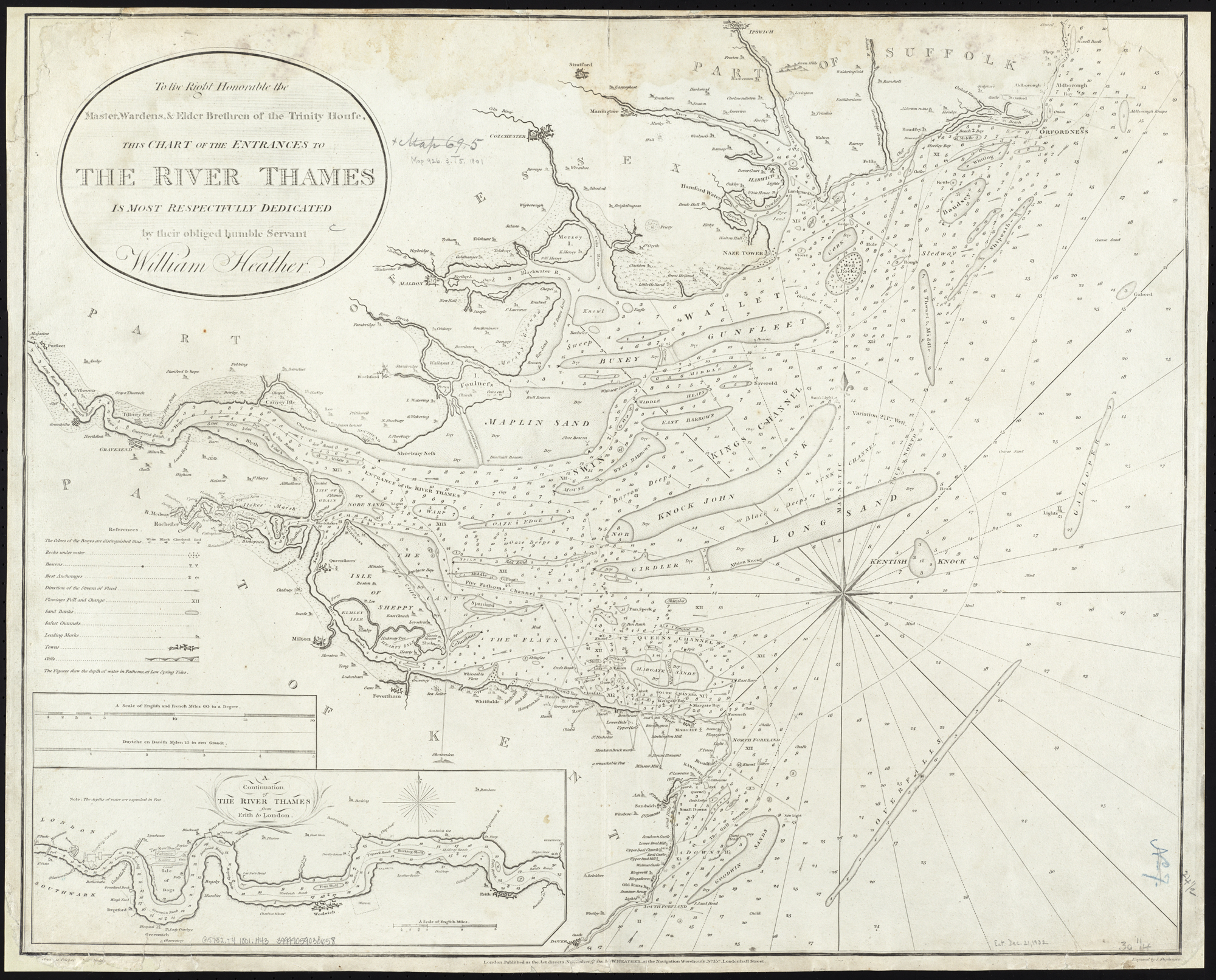
To the Right Honourable the Master, Wardens, & Elder Bretham of the Trinity House, this chart of the entrances to The River Thames is ... dedicated (8250889146).jpg - File Upload Bot (Magnus Manske)

Quinta Europae tabula (7537878534).jpg - File Upload Bot (Magnus Manske)

Map showing the bounds of the Province lands of the Commonwealth of Massachusetts, as fixed and marked by the Board of Harbor and Land Commissioners of said Commonwealth, under chapter 470 of the Acts of 1893.jpg - Grolltech

The operatic war in New York LCCN2012645537.jpg - Fæ

Got 'im at last. Fort McLeod 1880 (13291070723).jpg - Fæ

A new chart of the River St. Lawrence from the Island of Anticosti to Lake Ontario (13149899083).jpg - Fæ

Now he's done it?-Sarkaley Baton 1877 (12243067464).jpg - Fæ

Herman Moll. The Turkish Empire in Europe, Asia and Africa. 1752.jpg - Geagea
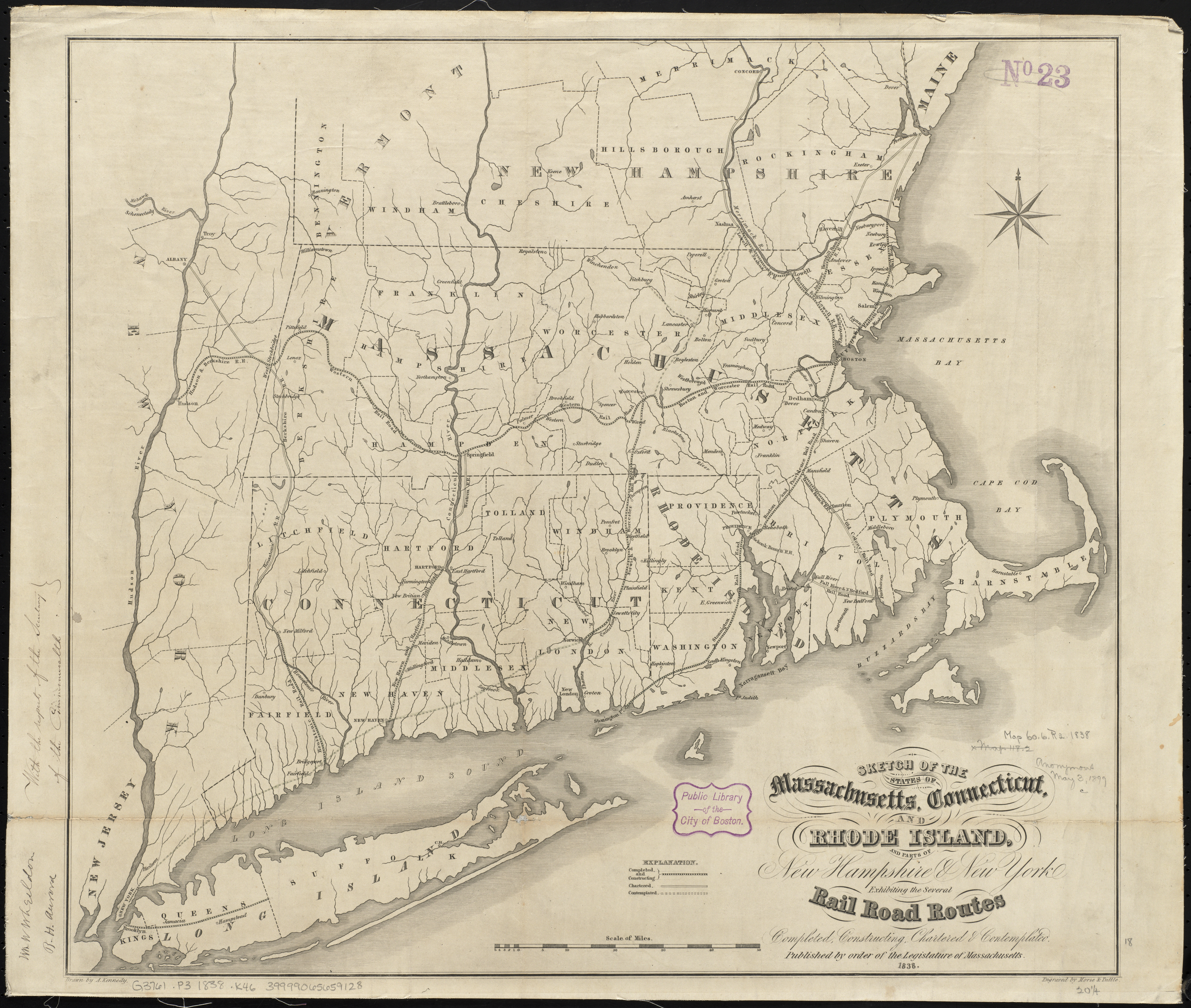
1838 Southern New England railroad map.jpg - Pi.1415926535

Mt. Agnes and Ground Hog Lake (15250424283).jpg - Sumita Roy Dutta

Clinton, 124 miles to Yale, 299 miles to Victoria (15534169351).jpg - Sumita Roy Dutta

Indian chief's grave on the road to Cariboo (15338618156).jpg - Sumita Roy Dutta

Spanish Chant Manuscript front cover (13915566713) (2).jpg - Sumita Roy Dutta

Spanish Chant Manuscript page 001 (13892391081) (2).jpg - Sumita Roy Dutta

Spanish Chant Manuscript page 002 (13915566913) (2).jpg - Sumita Roy Dutta

Spanish Chant Manuscript page 004 (13892397956) (2).jpg - Sumita Roy Dutta

Spanish Chant Manuscript page 003 (13915567073) (2).jpg - Sumita Roy Dutta

Spanish Chant Manuscript page 007 (13915935414) (2).jpg - Sumita Roy Dutta

Spanish Chant Manuscript page 008 - folio 1 recto (13892390392) (2).jpg - Sumita Roy Dutta

Spanish Chant Manuscript page 013 (13915935524) (2).jpg - Sumita Roy Dutta

Spanish Chant Manuscript page 005 (13892398126).jpg - Sumita Roy Dutta

Spanish Chant Manuscript page 019 (13892398686) (2).jpg - Sumita Roy Dutta

Spanish Chant Manuscript page 010 (13915935714) (2).jpg - Sumita Roy Dutta

Spanish Chant Manuscript page 015 (13892391701) (2).jpg - Sumita Roy Dutta

Spanish Chant Manuscript page 012 (13892391351) (2).jpg - Sumita Roy Dutta

Spanish Chant Manuscript page 018 (13892391881) (2).jpg - Sumita Roy Dutta

Spanish Chant Manuscript page 22 (13888210999).jpg - Sumita Roy Dutta

Spanish Chant Manuscript page 009 (13892391251) (2).jpg - Sumita Roy Dutta

Spanish Chant Manuscript page 006 (13892391131) (2).jpg - Sumita Roy Dutta

Spanish Chant Manuscript page 20 (14071672652).jpg - Sumita Roy Dutta

Spanish Chant Manuscript page 23 (14075304924).jpg - Sumita Roy Dutta

Spanish Chant Manuscript page 017 (13915566773) (2).jpg - Sumita Roy Dutta

Spanish Chant Manuscript page 011 - folio 2 verso (13915935704) (2).jpg - Sumita Roy Dutta

Spanish Chant Manuscript page 24 (14074827745).jpg - Sumita Roy Dutta

Spanish Chant Manuscript page 016 (13892398476).jpg - Sumita Roy Dutta

Spanish Chant Manuscript page 21 (14074828355).jpg - Sumita Roy Dutta

Map of Cape Nome and Golovin Bay (13992115461).jpg - Mario1952

1876 Map showing horse rail roads and the surface steam roads with 104 stations in and around Boston, including 91 surface steam R.R. stations within a radius of six miles from City Hall.jpg - Pi.1415926535

Rembrandt or Samuel Hoogstraten - Young Man in a Turban.jpg - Jane023

The operatic war in N. Y. (19501791605).jpg - Томасина

Rembrandt - Lazarus - Artic.jpg - Jane023

Rawson, A.L. Map of Palestine and all Bible lands. 1873.jpg - Geagea
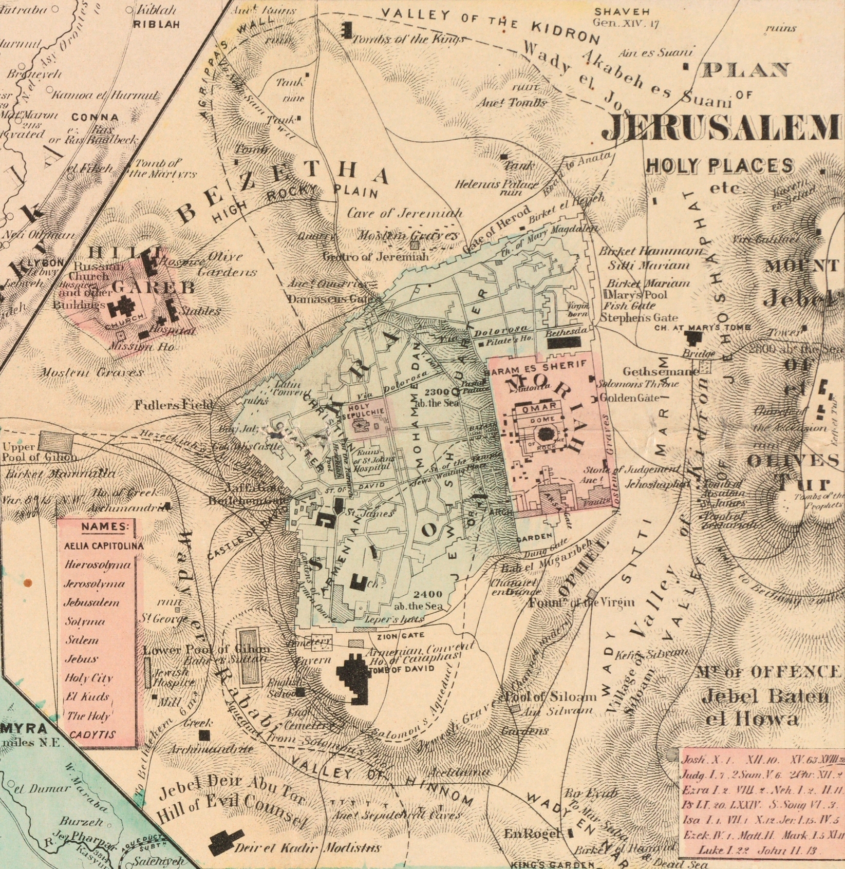
Jerusalem. Rawson, A.L. Map of Palestine and all Bible lands. 1873.jpg - Geagea

Sinai Peninsula. Rawson, A.L. Map of Palestine and all Bible lands. 1873.jpg - Geagea

View of Jerusalem. Rawson, A.L. Map of Palestine and all Bible lands. 1873.jpg - Geagea

Asher. Rawson, A.L. Map of Palestine and all Bible lands. 1873.jpg - Geagea

Acre Aqueduct. Asher. Rawson, A.L. Map of Palestine and all Bible lands. 1873.jpg - Geagea

Gauguin 1891 Portrait de Stéphane Mallarmé.jpg - Vriullop

(Two panoramic aerial views of downtown Vancouver- 1891 & 1923) (12817812234).jpg - Mikey641

(View of train crossing trestle bridge) (12817479693).jpg - Mikey641

(Portrait of the attendees of the Sixth Biennial Conference of the Institute of Pacific Relations) (12483792294).jpg - Mikey641

Valley of the Mooyie River N.W. Boundry (sic) 1860 (12679799174).jpg - Mikey641

(View of Victorian park scene) (12483539114).jpg - Mikey641

Universali Tabula.jpg - LlywelynII

Sea of Galilee. A map of Canaan (8343807206) (cropped).jpg - Geagea

Athenian Tribute List 2 (23478010265).jpg - Fæ

Athenian Tribute List 9 (23182220890).jpg - Fæ

Athenian Tribute List 10 (23478010275).jpg - Fæ

Athenian Tribute List 15 (23182220830).jpg - Fæ

Athenian Tribute List 15 (23110023429).jpg - Fæ

Athenian Tribute List 25 (23369484092).jpg - Fæ

Decreta de Hestiaeensibus (22850851883).jpg - Fæ

Decreta de Hestiaeensibus (22850851763).jpg - Fæ

De Reginorum Foedere (23451860946).jpg - Fæ

De Aede Minervae Poliadis Conficienda (23110022749).jpg - Fæ

Hominis Illyrii Proxenia (23110023539).jpg - Fæ

Rationes Belli Samii (23110023409).jpg - Fæ

IG I3 0366d, squeeze.jpg - Fæ

Rationes Expeditionum Macedoniae, Potidaeaticae, Pelopennesiacae (23110022989).jpg - Fæ

Rationes Expeditionum Macedoniae, Potidaeaticae, Pelopennesiacae (23369484192).jpg - Fæ

Traditiones Quaestorum Reliquorum Deorum (23369484342).jpg - Fæ

Athenienses Et Socii Qui Drabesci (?) In Chersonneso, Thasii Occuberunt (22850851013).jpg - Fæ

IG I3 1187c, squeeze.jpg - Fæ

The Holy Sepulcre. Herman Moll. The Turkish Empire in Europe, Asia and Africa. 1752 (cropped).jpg - Geagea

The Holy Sepulcre (outside).Herman Moll. The Turkish Empire in Europe, Asia and Africa. 1752 (cropped).jpg - Geagea

The Church of the Holy Sepulcre. Herman Moll. The Turkish Empire in Europe, Asia and Africa. 1752 (cropped).jpg - Geagea

Jerusalem. Herman Moll. The Turkish Empire in Europe, Asia and Africa. 1752 (cropped).jpg - Geagea

The plan of Constantinople. Herman Moll. The Turkish Empire in Europe, Asia and Africa. 1752 (cropped).jpg - Geagea

Smiran. Herman Moll. The Turkish Empire in Europe, Asia and Africa. 1752 (cropped).jpg - Geagea

Italy. Herman Moll. The Turkish Empire in Europe, Asia and Africa. 1752 (cropped).jpg - Geagea

Egypt. Herman Moll. The Turkish Empire in Europe, Asia and Africa. 1752 (cropped).jpg - Geagea

Middle East. Herman Moll. The Turkish Empire in Europe, Asia and Africa. 1752 (cropped).jpg - Geagea

Black Sea. Herman Moll. The Turkish Empire in Europe, Asia and Africa. 1752 (cropped).jpg - Geagea

Paul Gustav Fischer, Kongens Fødselsdag, 1925.jpg - Villy Fink Isaksen

Pieter Bruegel de Oude - Vlaamse spreekwoorden 08873.jpg - Jane023
Adolphe Monticelli - A Woodland Fête - 1954.832 - Cleveland Museum of Art.tiff - BotMultichill
Adolphe Monticelli - Autumn - 1951.328 - Cleveland Museum of Art.tif - Madreiling
Adolphe Charles Edouard Steinheil - Judge in Red Robe - 2013.260 - Cleveland Museum of Art.tif - Madreiling

Ducato di Ferrara (8342170795) (cropped).jpg - Threecharlie

Rawson, A.L. Map of Sinai Peninsula. 1873.jpg - Enyavar

Rawson, A.L. Map of Jerusalem. 1873.jpg - Enyavar

Rawson, A.L. Map of Apostel Paul's Travels. 1873.jpg - Enyavar