Wikimedi'Òc
Modes d'emploi

Cet album fait partie des albums
Cet album photos contient les sous-albums suivants :


Railway bridges at the end of Brussels Street - geograph.org.uk - 7086067.jpg - GeographBot

Railway cutting east of Pontefract Lane, Leeds - geograph.org.uk - 4990605.jpg - GeographBot

The A63 and Main Railway Line into Hull.jpg - Keith D

Garforth - Micklefield Railway from Ridge Bridge - geograph.org.uk - 125375.jpg - GeographBot
Micklefield - Garforth Railway from Ridge Bridge - geograph.org.uk - 126483.jpg - GeographBot

Level crossing - geograph.org.uk - 155268.jpg - GeographBot

Main Railway Line into Hull - geograph.org.uk - 161067.jpg - GeographBot

Sewage Works - geograph.org.uk - 112738.jpg - GeographBot

Railway Bridge - geograph.org.uk - 241449.jpg - GeographBot

Railway Bridge - geograph.org.uk - 241538.jpg - GeographBot
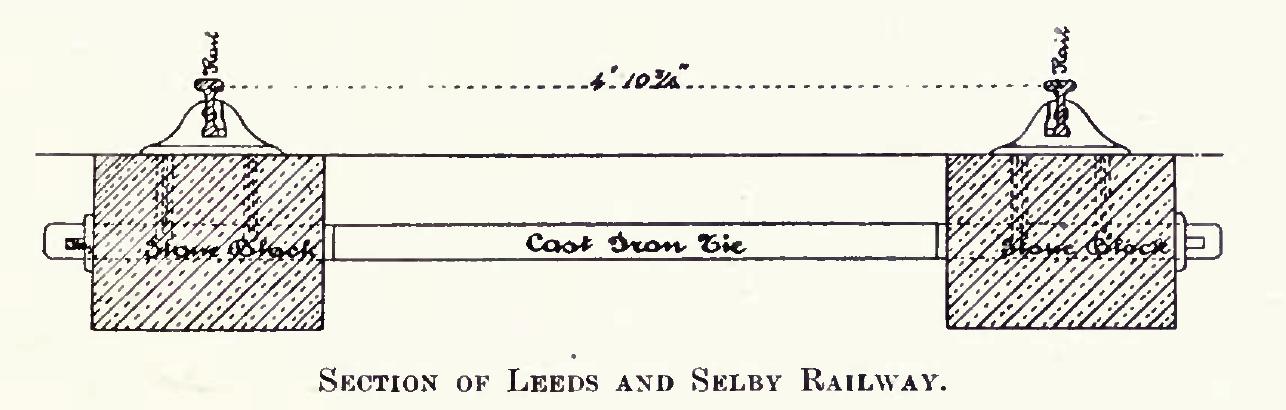
Diagram of section of ladder track type of sleeper on Leeds and Selby Railway.JPG - Sf5xeplus

Diagram of section of Leeds and Selby Railway Chair showing rail and key.JPG - Sf5xeplus
Successive Transport Systems - geograph.org.uk - 250144.jpg - GeographBot

The Market Weighton Canal - geograph.org.uk - 250142.jpg - GeographBot

Rail and Road at Hessle - geograph.org.uk - 318888.jpg - GeographBot

Railway bridge under the A63 - geograph.org.uk - 343532.jpg - GeographBot

The Line towards Brough - geograph.org.uk - 529260.jpg - GeographBot

Heaton's Court - off Lower Briggate - geograph.org.uk - 538168.jpg - GeographBot

Level crossing over main Leeds-York line - geograph.org.uk - 566435.jpg - GeographBot

Right side of the tracks - geograph.org.uk - 569221.jpg - GeographBot

Railway Crossing - geograph.org.uk - 610252.jpg - GeographBot

The Lane to Crabley Crossing - geograph.org.uk - 610302.jpg - GeographBot

Hull to Selby Line - geograph.org.uk - 629527.jpg - GeographBot
Hotel Elizabeth, North Ferriby - geograph.org.uk - 688799.jpg - GeographBot

Skillings Lane Level Crossing, Brough - geograph.org.uk - 751156.jpg - GeographBot

The Railway towards Gilberdyke - geograph.org.uk - 753397.jpg - GeographBot

View from Bridge HUL4-34 - Pontefract Lane - geograph.org.uk - 995068.jpg - GeographBot

View from Bridge HUL4-35 - Pontefract Street - geograph.org.uk - 995118.jpg - GeographBot

Rail Bridge and Parish Church - geograph.org.uk - 1070591.jpg - GeographBot

Ellerker Drain - geograph.org.uk - 1186980.jpg - GeographBot

The railway west of Brough - geograph.org.uk - 1186954.jpg - GeographBot

View from Bridge HUL 4-33 - Park Parade - geograph.org.uk - 1241772.jpg - GeographBot

View from Bridge HUL 4-33 - Park Parade - geograph.org.uk - 1241773.jpg - GeographBot

Brough Level Crossing - geograph.org.uk - 1466145.jpg - GeographBot

Railway from Melton Bridge to Melton Crossing - geograph.org.uk - 1462076.jpg - GeographBot

The Market Weighton Canal - geograph.org.uk - 1466215.jpg - GeographBot

Railway Line towards Hull - geograph.org.uk - 1604780.jpg - GeographBot

View looking east along the A63 from Humber Bridge - panoramio.jpg - Panoramio upload bot
Osmondthorpe Halt railway station (site), Yorkshire (geograph 3468725).jpg - Schlosser67

The humber bridge from a train (43229902111).jpg - Jayberries

Rail lines toward Howden Station (geograph 6101816).jpg - Keith D

Rail lines going west from footpath crossing (geograph 6101818).jpg - Keith D

Brough, Railway, looking west - geograph.org.uk - 1881157.jpg - GeographBot

All Brass ^ Woodwind - York Street - geograph.org.uk - 1985762.jpg - GeographBot

Bridge over the Railway - geograph.org.uk - 1987629.jpg - GeographBot

A walk from Oulton Church ^33 - geograph.org.uk - 2011185.jpg - GeographBot

Railway line towards Hull - geograph.org.uk - 2024116.jpg - GeographBot

Railway lines towards Selby - geograph.org.uk - 2325017.jpg - GeographBot

A record breaker - geograph.org.uk - 2392834.jpg - GeographBot

Brady Farm Bridge.jpg - Peter I. Vardy

Railway heading east from Leeds Station towards Selby - geograph.org.uk - 2469994.jpg - GeographBot
Railway heading east - geograph.org.uk - 2754531.jpg - GeographBot

The Track to Brough (geograph 3316513).jpg - Keith D

Melton railway bridge carrying Brickyard Lane (geograph 4480982).jpg - Keith D

Cutting west of North Ferriby (geograph 4540759).jpg - Keith D

Cutting west of North Ferriby (geograph 4540760).jpg - Keith D

Cutting west of Melton Bridge (geograph 4549920).jpg - Keith D

Train between Melton Bridge and Long Plantation (geograph 4976002).jpg - Keith D

Train passing Melton Crossing for North Ferriby (geograph 4976089).jpg - Keith D

York-Leeds railway line from Sutton Approach footbridge - geograph.org.uk - 3468768.jpg - GeographBot

Works by the railway line (geograph 4549929).jpg - Keith D

Signal at Welton Crossing (geograph 4136632).jpg - Keith D

Railway at Welton Crossing (geograph 4383800).jpg - Keith D

Signals at Welton Crossing, near Brough (geograph 4956758).jpg - Keith D

Railway at North Ferriby (geograph 5692123).jpg - Keith D

Railway bridge at junction of The Calls and Crown Street - geograph.org.uk - 3775062.jpg - GeographBot

Railway Bridge HUL4-40 Marsh Lane - geograph.org.uk - 3777647.jpg - GeographBot

Oxmardyke Level Crossing - geograph.org.uk - 3786594.jpg - GeographBot

Rail track - viewed from Bridge, end of Sutton Approach - geograph.org.uk - 4021120.jpg - GeographBot

Rail track - viewed from Bridge, end of Sutton Approach - geograph.org.uk - 4021128.jpg - GeographBot

In a cutting near Cross Gates Station - geograph.org.uk - 4620424.jpg - GeographBot

Railway - geograph.org.uk - 4749426.jpg - GeographBot

Selby line.png - Rcsprinter123

Bridge over the railway, Upper Accommodation Road, Leeds - geograph.org.uk - 4830025.jpg - GeographBot

Richmond Hill railway cutting east of Leeds - geograph.org.uk - 4830034.jpg - GeographBot

Back of The Viaduct Show Bar, Leeds - geograph.org.uk - 4850377.jpg - GeographBot

Crossing the Selby - Hull railway - geograph.org.uk - 5099810.jpg - GeographBot

Railway Line toward Caville Bridge - geograph.org.uk - 6102960.jpg - GeographBot

Selby Line and DWP Quarry House Leeds - Apr 10, 2022.jpg - Krorokeroro

Crossing to nowhere....yet - geograph.org.uk - 6814062.jpg - GeographBot

From a York-Selby train - Control tower at Gascoigne Wood sidings - geograph.org.uk - 7821558.jpg - GeographBot