Wikimedi'Òc
Modes d'emploi

Cet album fait partie des albums
Cet album photos contient les sous-albums suivants :


Blockship in Holm Sound - geograph.org.uk - 7446479.jpg - GeographBot

Blockship in Holm Sound - geograph.org.uk - 7446482.jpg - GeographBot

Holm Sound - geograph.org.uk - 7446446.jpg - GeographBot

Scapa Flow from the A964 - geograph.org.uk - 7443668.jpg - GeographBot

The wreck of the blockship SS Reginald - geograph.org.uk - 7446504.jpg - GeographBot

Seydlitz steams to Scapa.jpg - JustSomePics
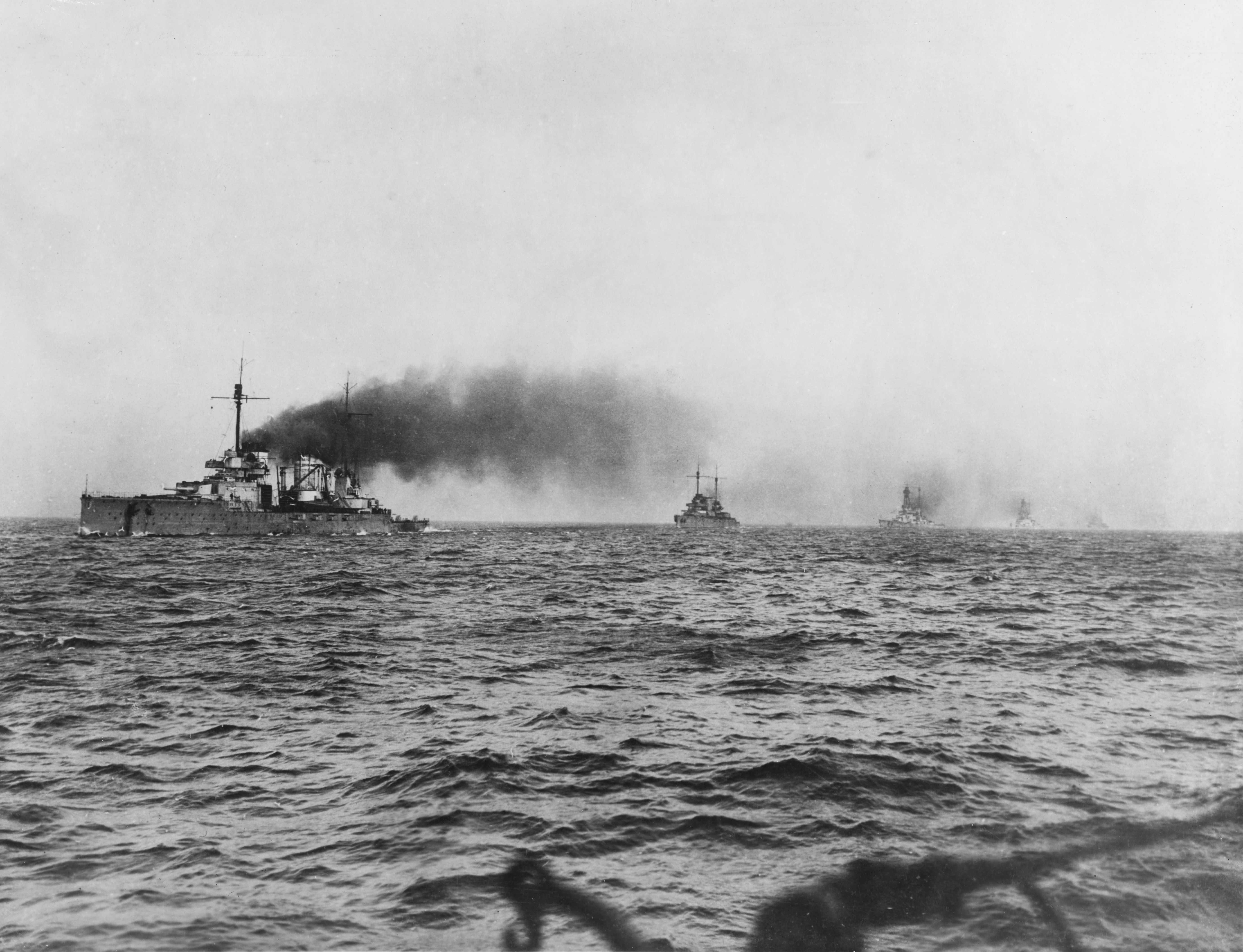
German battlecruisers steaming to Scapa.jpg - Alonso de Mendoza

Scapa Flow, British pottery shard (RLH).JPG - Richard Harvey

Scapa Flow, German pottery shard (RLH).JPG - Richard Harvey
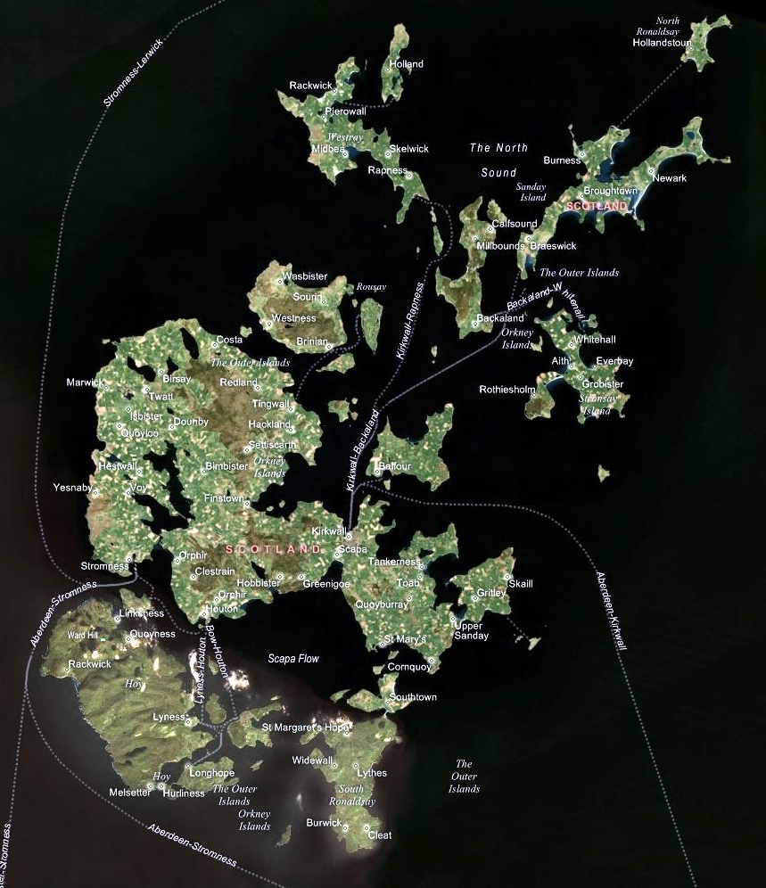
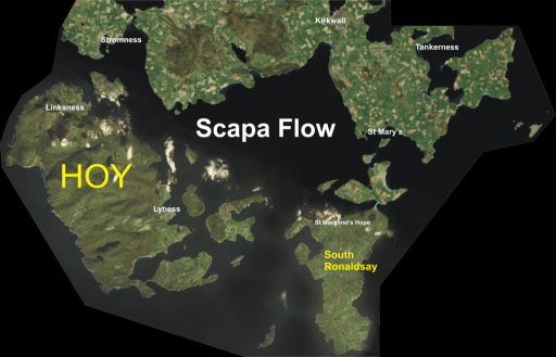
Orkney Islands.jpg - Richard Harvey

U-47 raid.svg - BillC

Kartskiss över Scapa flow.png - Nicke L

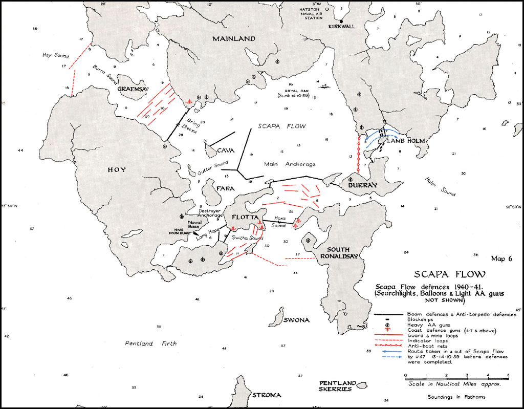
Scapa Flow.svg - Siałababamak
Scapa Flow.jpg - Gonzosft

Scapa Flow(RLH).png - Rino ap Codkelden
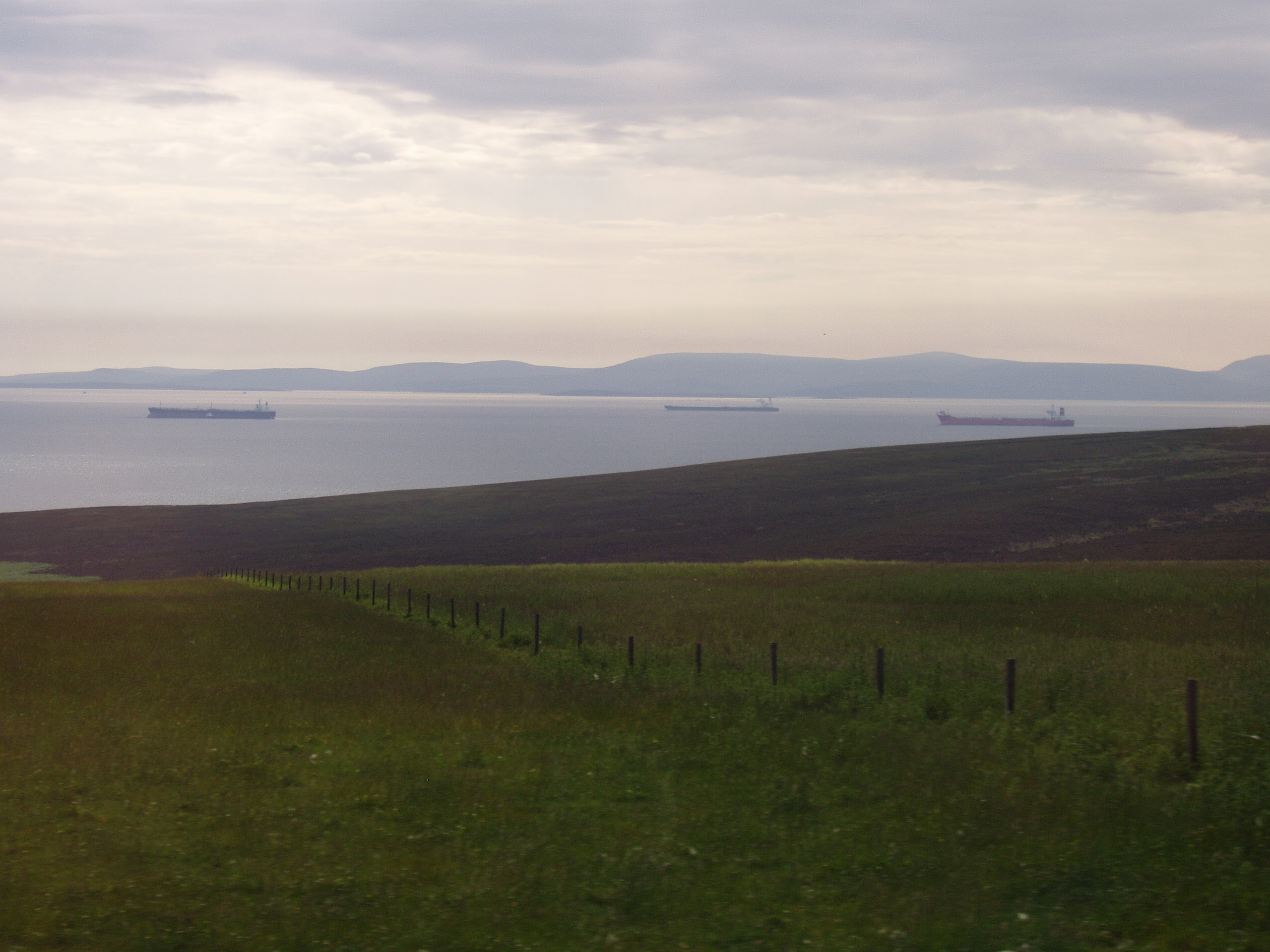
Tankers in Scapa Flow - Mainland Orkney - kingsley - 29-JUN-09.JPG - Gregory J Kingsley

Scapa Flow - Churchill Barrier 1 - kingsley - 29-JUN-09.JPG - Gregory J Kingsley
Scapa Flow RLH half size.png - Ineuw

Northlink ferry in Scapa Flow - geograph.org.uk - 195810.jpg - GeographBot

View across Scapa Flow from HY479032 crossroads - geograph.org.uk - 235326.jpg - GeographBot

Skalpaflói.svg - Jfgjymfkhjljhil

Inner Holmes from the Hamnavoe - geograph.org.uk - 359456.jpg - GeographBot

Sunset, towards Hoy - geograph.org.uk - 854659.jpg - GeographBot

Flotta oil terminal across Scapa Flow - geograph.org.uk - 931811.jpg - GeographBot

Scapa Flow - geograph.org.uk - 931817.jpg - GeographBot

Innan Neb gun battery and observation tower - geograph.org.uk - 1065315.jpg - GeographBot

Lane to Dyke-end - geograph.org.uk - 1077404.jpg - GeographBot

Track to Lint Brae - geograph.org.uk - 1077363.jpg - GeographBot

Pasture and tankers - geograph.org.uk - 1127375.jpg - GeographBot

The Tongue of Gangsta - geograph.org.uk - 1127334.jpg - GeographBot

Gravel beach and east side of Outer Holm - geograph.org.uk - 1203159.jpg - GeographBot

Moorland near the Burn of Swartabeck - geograph.org.uk - 1247620.jpg - GeographBot

Rock pool at Mid Taing - geograph.org.uk - 1242081.jpg - GeographBot

Looking across Scapa Bay - geograph.org.uk - 1265825.jpg - GeographBot

Mid Taing, Scapa Bay - geograph.org.uk - 1267113.jpg - GeographBot

Coastal fence - geograph.org.uk - 1299285.jpg - GeographBot

Concrete trough - geograph.org.uk - 1299327.jpg - GeographBot

Commercial Divers - geograph.org.uk - 1490679.jpg - GeographBot

Cutting equipment - geograph.org.uk - 1490707.jpg - GeographBot

Diver underwater - geograph.org.uk - 1490958.jpg - GeographBot
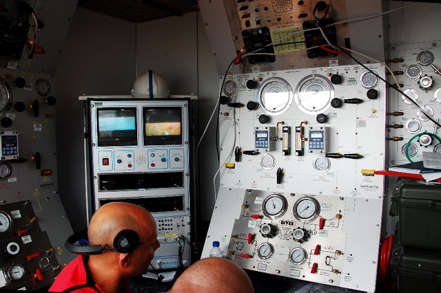
Diving control room - geograph.org.uk - 1491069.jpg - GeographBot

Final preparations - geograph.org.uk - 1490807.jpg - GeographBot

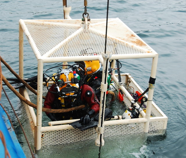
Going down - geograph.org.uk - 1490876.jpg - GeographBot

HMS Royal Oak Wreck Buoy - geograph.org.uk - 1491044.jpg - GeographBot

Hitting the water - geograph.org.uk - 1490893.jpg - GeographBot
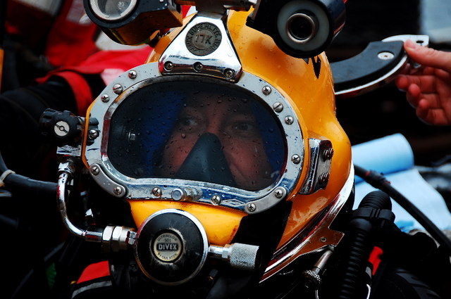
Kirby Morgan Superlite - geograph.org.uk - 1490773.jpg - GeographBot

Kitting up - geograph.org.uk - 1490799.jpg - GeographBot

Ministry of Defence Salvage - geograph.org.uk - 1491098.jpg - GeographBot

Oil boom and barges - geograph.org.uk - 1490553.jpg - GeographBot

Over the wreck - geograph.org.uk - 1490940.jpg - GeographBot
Raising the divers - geograph.org.uk - 1490611.jpg - GeographBot

The Josine - geograph.org.uk - 1490970.jpg - GeographBot

The deck of the Cameron - geograph.org.uk - 1490749.jpg - GeographBot

The diving lift - geograph.org.uk - 1490629.jpg - GeographBot
What it's all about - geograph.org.uk - 1490926.jpg - GeographBot

Raft and blockship in Weddell Sound. - geograph.org.uk - 1510783.jpg - GeographBot

End of a long day creeling. - geograph.org.uk - 1710707.jpg - GeographBot

Ferry traffic on the barrier - geograph.org.uk - 1710633.jpg - GeographBot
Sunset over The Empire Seaman - geograph.org.uk - 1710725.jpg - GeographBot

Ness Battery, Stromness, Orkney. Battery Observation Post.jpg - Fine Hid

Infiltración del U 47 en Scapa Flow.png - Alonso de Mendoza

Sub-Lieutenant H V Bartlett (6279267487).jpg - File Upload Bot (Magnus Manske)

Geschützstand Stromness.jpg - Tine
Royaloak.JPG - Wdwdbot

Scapaflow.JPG - Wdwdbot

Scapa Flow location.png - Matrek

Houton Ferry to Hoy - panoramio.jpg - Panoramio upload bot
The South Isles of Orkney, to show the situation and extent of Scapa Flow, as a proposed roadsted for line-of-battle-ships, most humbly presented to the Rt. Honble. the Lords Comissioners of the Admiralty- by Graeme Spence, RMG F0107.tiff - Fæ

Studies of one of the entrances to Scapa Flow and of an observation balloon RMG PV3500.jpg - Fæ

Ordnance Survey One-Inch Sheet 6 Orkney (Kirkwall), Published 1959.jpg - Kognos

Ordnance Survey One-Inch Sheet 6 Orkney Islands (Mainland), Published 1948.jpg - Kognos

Admiralty Chart No 2181 Scotland east coast sheet 5 Ord of Caithness to Thurso Bay including the Pentland Firth, Published 1853.jpg - Kognos

Admiralty Chart No 2180b Southern portion of the Orkney Islands, Scotland, Published 1886.jpg - Kognos

2018 07 12 Schottland (36).jpg - Bewahrerderwerte

Emblem of HMS Royal Oak at a monument at Scapa Flow, 11.08.15.jpg - Liberaler Humanist

The bay of Scapa Flow.jpg - Liberaler Humanist

Churchill Barriers (26259000377).jpg - Matlin

View from Lowertown, overlooking Scapa Flow - geograph.org.uk - 2047210.jpg - GeographBot

Illuminated Salmon breeding cages - geograph.org.uk - 2291199.jpg - GeographBot

The Lash Skerry - geograph.org.uk - 2296196.jpg - GeographBot

Hoxa Head, Scapa Flow defences - geograph.org.uk - 2474456.jpg - GeographBot

Admiralty Chart No 2581 Scapa Flow and Approaches Southern Sheet, Published 1909.jpg - Kognos

Admiralty Chart No 3729 Scapa Flow and Approaches Northern Sheet, Published 1909.jpg - Kognos

Admiralty Chart No 2581 Long Hope and Widewall Harbour, Published 1858.jpg - Kognos

Looking over Scapa Flow at Houton Bay - geograph.org.uk - 2671003.jpg - GeographBot

Admiralty Chart No 2578 South West portion of Scapa Flow - including Cantick and Switha Sounds, Published 1927.jpg - Kognos

Scapa Flow vessels - geograph.org.uk - 2884257.jpg - GeographBot

Pentalina, heading towards Scrabster, from Hoxa - geograph.org.uk - 3035274.jpg - GeographBot

Entrance to Scapa Flow, from Cantick Head - geograph.org.uk - 3195307.jpg - GeographBot

The Pentalina - geograph.org.uk - 3264269.jpg - GeographBot

View south-west from Hurtiso, Mainland, Orkney - geograph.org.uk - 3341443.jpg - GeographBot

Gill Bay and Lowertown - geograph.org.uk - 3483645.jpg - GeographBot
Rain shower over Scapa Flow - geograph.org.uk - 3699447.jpg - GeographBot

Coastal grassland by The Bu - geograph.org.uk - 3701141.jpg - GeographBot

Mast of the block ship 'Emerald Wings' - geograph.org.uk - 4010048.jpg - GeographBot

Crane pontoon sunk as a block ship in 1944 - geograph.org.uk - 4010050.jpg - GeographBot

SPM No. 1, Scapa Flow, Orkney - geograph.org.uk - 4186941.jpg - GeographBot

SPM No. 1 and Grey Atlantic seal, Scapa Flow, Orkney - geograph.org.uk - 4186958.jpg - GeographBot

Grey Atlantic seal on SPM No. 1, Scapa Flow, Orkney - geograph.org.uk - 4186980.jpg - GeographBot

The wake of the Pentalina - geograph.org.uk - 4474622.jpg - GeographBot

The wake of the Pentalina - geograph.org.uk - 4475059.jpg - GeographBot

Alien arrival, edge of daylight - geograph.org.uk - 4752349.jpg - GeographBot

Torpedo net, Scapa Flow museum.jpg - Mike Capp

Cantick Head Lighthouse from the Orkney Ferry - geograph.org.uk - 5317332.jpg - GeographBot

German battlecruisers steaming to Scapa (cropped).jpg - Cléééston

Calf of Cava - geograph.org.uk - 5815867.jpg - GeographBot

Royal Oak scapa.jpg - Melissa Highton

Blockship 'Inverlane' between Graemsay and Hoy - geograph.org.uk - 6446442.jpg - GeographBot

Blockship 'Inverlane' between Graemsay and Hoy - geograph.org.uk - 6446444.jpg - GeographBot

Admiralty Chart No 35 Scapa Flow Northern Part, Published 1944.jpg - Kognos

Seydlitz steams to Scapa (cropped).jpg - Cléééston

Fish farm, Scapa Flow, Orkney - geograph.org.uk - 7209513.jpg - GeographBot

Barrel of Butter navigation light, Scapa Flow - geograph.org.uk - 7266330.jpg - GeographBot
Nevi Skerry beacon - geograph.org.uk - 7556457.jpg - GeographBot
Gevechtseenheid van de Britse marine voor anker in Scapa Flow, asset kcAcVXgHOPVFhesMFgU7sJ0y.tif - Mr.Nostalgic
Het Britse marineschip Bellerophonen gevechtskruisers van de Britse marine te Scapa Flow, asset R1iOjX4No5ZidLsNSa4vF59T.tif - Mr.Nostalgic

Le "Prince-Régent Leopold" renfloué à Scapa (Flow) - btv1b532721074.jpg - Gzen92Bot