Wikimedi'Òc
Modes d'emploi

Cet album fait partie des albums
Cet album photos contient les sous-albums suivants :


USSRmap.svg - Tat1642

Former USSR Oil and Gas map.svg - Sasha Krotov

USSR map.svg - Master Uegly

Republics of the USSR.svg - কুউ পুলক

Union of Soviet Socialist Republics (orthographic projection).svg - ReneeWrites

New Union Treaty.svg - Wereldburger758

Communist block.svg - ZaidRock11

Union of Soviet Socialist Republics (orthographic projection)-Flag version.svg - The Emirr

Communist countries.svg - PharaohCrab

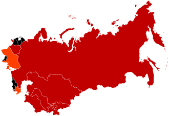
Nachfolgestaatenudssr.svg - Ktrinko

Map of USSR with SSR names.svg - Master Uegly

Назінська трагедія (карта).svg - VictorAnyakin

European Soviet Union.svg - Milenioscuro

Location map of the USSR.svg - Milenioscuro

USSR location map.svg - Secretlondon

Republics of the USSR ur.svg - Tahir mq

European Soviet Union laea location map.svg - NordNordWest

Soviet Union (European part) location map.svg - Hellerick

Soviet Union location map.svg - Hellerick

Soviet Union location map (no rivers).svg - Hellerick

Soviet Union location map (1937).svg - Hellerick

Soviet Union location map (1937, no rivers).svg - Hellerick

Soviet Union referendum, 1991 results.svg - MBH

Soviet Union location map (provinces).svg - ToprakM

Subdivisions of the Soviet Union.svg - Hellerick

USSR Map (10-1990 - 12-1991).svg - Master Uegly

Soviet Union 1989 with Warsaw Pact, modern borders.svg - Erincj

Soviet Union on the globe (Soviet Union centered).svg - Stasyan117

Soviet Union (1956-1991).svg - Knyaz-1988

Soviet Union 1922.svg - Colohisto

Soviet Union (1940).svg - Knyaz-1988

Soviet Union 1924.svg - Nicolay Sidorov

Soviet Union 1929.svg - Nicolay Sidorov

Soviet Union 1936.svg - Knyaz-1988

USSR in EurAsia.svg - Stasyan117

Union of Soviet Socialist Republics (1989).svg - TRAJAN 117

Soviet Influence (1960).svg - TRAJAN 117

Soviet Influence (1970).svg - TRAJAN 117

Soviet Influence (1980).svg - TRAJAN 117

Soviet Influence (1990).svg - TRAJAN 117

Крупнейшие города СССР.svg - Interchange88

Largest cities USSR 1989.svg - Interchange88

Central Chernozem Oblast administrative division map (1930).svg - Hellerick

USSR Republics numbered by Constitution.svg - Master Uegly

USSR Republics numbered by alphabet.svg - Master Uegly

Chornobyl raion (1923-1988) with modern Alienation Zone.svg - Juras14

Expansión territorial de Rusia.svg - Mzajac

Population distribution of Kurds in the USSR in 1989.svg - ToprakM

Expansion territoriale de la Russie.svg - Pacharus

Академсеть СССР.svg - DS28

Academset USSR.svg - DS28

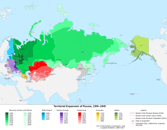
Territorial Expansion of Russia.svg - Danshirya

SovietUnionRussia.svg - Trav1085

USSR Republics numbered by Thai alphabet.svg - Potapt

1989 Soviet election turnout by republic.svg - Kingofthedead

Territorial extent of the Union of Soviet Socialist Republics (1944-1991).png - Yugomeister

Union Republics of the Union of Soviet Socialist Republics (1944-1991).png - Yugomeister

Republics of the Union of Soviet Socialist Republics (1922).png - Yugomeister

Republics of the Union of Soviet Socialist Republics (1925).png - Yugomeister

Republics of the Union of Soviet Socialist Republics (1929).png - Yugomeister

Republics of the Union of Soviet Socialist Republics (1936).png - Yugomeister

Territorial extent of the Union of Soviet Socialist Republics (1922-1940).png - Yugomeister

Soviet successor states (without disputed or occupied territories).png - Yugomeister

Soviet Union 1925.svg - Colohisto