Wikimedi'Òc
Modes d'emploi

Cet album fait partie des albums
Cet album photos contient les sous-albums suivants :


Mandatory Palestine Silhouette Template.svg - Hstoops

Królestwo Heroda.svg - MesserWoland

Izrael - społeczność żydowska.svg - MesserWoland

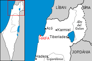
Localització de Haifa.svg - Rf~commonswiki

Localització d'Ir ha-Karmel.svg - Rf~commonswiki

Localització de Neixer.svg - Rf~commonswiki

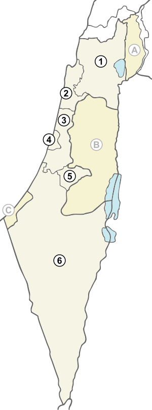
Israel districts numbered.svg - Arz

BarrierMay2005.svg - QWerk

Hattin-map.svg - Cumulus

Israel war crusaders.svg - Cumulus

Jizre'elské údolí.svg - Daniel Baránek

Upper galil.svg - רונאלדיניו המלך

HulaArabic.svg - Drork

West galil.svg - רונאלדיניו המלך

Emek-beit-shean.svg - Costello

Carmel.svg - רונאלדיניו המלך

Netanya.svg - Costello

North-shomron.svg - Costello

Tel-aviv area.svg - Costello

Locations-israel.svg - DMY

HulaHebrew.svg - Drork

South Shomron.svg - Costello

Jerusalem area.svg - Costello

HaShfela.svg - Costello

MtHebron.svg - Costello

GazaWestNegev.svg - Costello

Reino de Herodes.svg - Rowanwindwhistler

Map of Masada.svg - Kordas

Israel administrative 2009.svg - Ynhockey

Israel 1949-1967.svg - Honza.havlicek

1967 Six Day War - Battle of Golan Heights.svg - FrozenCourgette

National Water Carrier of Israel.svg - MT0

Israel dialing codes.svg - Ori~

Haifa in 1922.svg - MT0

National Water Carrier of Israel ru.png - ASchwarz

Sefarjardeni.svg - Ori~

Arab League Israel.svg - Hogweard

Kingdoms of Israel and Judah map 830.svg - Sadopaul

Kingdom of Israel 1020 map.svg - Malus Catulus

Maccabean Revolt he.svg - Effib

Zones juives 1dec47 + relief.svg - Andreasmperu

Jerusalem arabic.svg - Kathovo

PositionskarteIrHaKarmel.svg - Ayin leZion

Etzba hagalil.svg - רונאלדיניו המלך

Map of Israel, neighbours and occupied territories-ru.svg - Express2000

Карта оккупированных палестинских территорий.svg - Kaidor

BeershebaNorthNegev.svg - DMY

EilatSouthNegev.svg - Geagea

MtHebronWest.svg - DMY

Map of Israel, neighbours and occupied territories-en.svg - LametinoWiki

Maktesh Ramon Map.svg - Matanya

הגבול הימי של ישראל.svg - Matanya

Latin Patriarch of Jerusalem.svg - NordNordWest

ISR orthographic.svg - Chaddy

New Partition Proposal.svg - Tcolgan001

Israel (orthographic projection).svg - Flappiefh

Zeelim lower trails.svg - Tamuz

Israel Map by The Legal Status of The Territories.svg - משתמש כבד

Israel Map by The Legal Status of The Territories-3.svg - משתמש כבד

Israel Map by The Legal Status of The Territories-2.svg - משתמש כבד

Israel Map by The Legal Status of The Territories-4.svg - Fippe

Maktesh Ramon Map WikiJourney.svg - Tamuz

Israel Map by The Legal Status of The Territories-5.svg - משתמש כבד

Israel Map by The Legal Status of The Territories-6.svg - משתמש כבד

National Water Carrier of Israel-en.svg - NielsF

Israel districts numbered with Cyrillic letters.svg - Bjankuloski06en

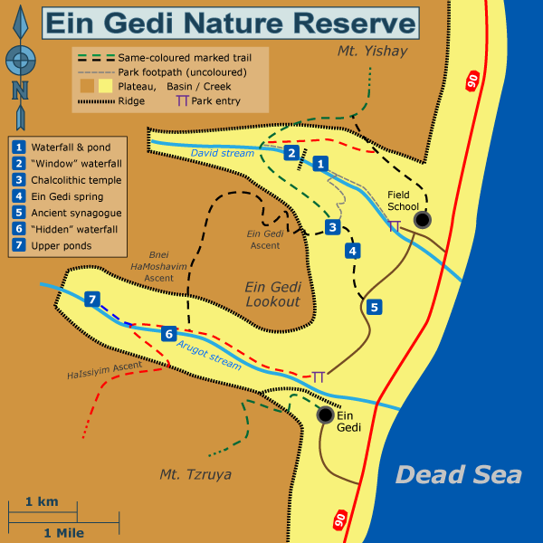
Ein Gedi Nature Reserve Scheme -text corrected.svg - Tamuz

Judean Desert outline he.svg - Tamuz

Sea of Galilee overview he.svg - Tamuz

Judean Desert outline en.svg - Tamuz

Guvta Stream outline he.svg - Tamuz

Eilat Mountains outline he.svg - Tamuz

ישראל 2.svg - Kfir8787

Maktesh Ramon Map Wikivoyage en.svg - Tamuz

Golan Trail en he.svg - Tamuz
Ein Gedi Nature Reserve Scheme en.png - Tamuz

Ein Gedi Nature Reserve Scheme en he.svg - Tamuz

Outside Masada.svg - Kordas

Holy Land map.svg - Ischa1

Map of Israel, neighbours and occupied territories-mk.svg - MacedonianBoy

Israel districts named hr.svg - MaGa

Sea of Galilee overview en.svg - Tamuz

Israel nach Sechstagekrieg.svg - Hoheit

Map Israël.svg - Gagiiboli

Avtalion.svg - Ijon

National Water Carrier of Israel -en.svg - AdamHej

Amos-6-Ka-band-coverage.svg - Cvdr

Kingdoms of Israel and Judah map 830-ru.svg - Bums

Kvish HaHof map.svg - קרלוס הגדול

Asia minor 1140-es.svg - Rowanwindwhistler

Edom-Moab-830BCE.svg - Erp

Map of Israel, neighbours and occupied territories-de.svg - Furfur

12 Tribes of Israel Map-de.svg - Online-today

UN Partition Plan For Palestine 1947 cy.svg - Llywelyn2000

Armistice agreement between Israel and the Arab States - 1949 (In Hebrew).svg - Mikey641

Armistice agreement between Israel and the Arab States - 1949 (In Hebrew)2.svg - קובץ על יד

Israel Brunei locator.svg - קובץ על יד

Koppen-Geiger Map ISR future.svg - NVergopolan

Areas under Israeli law.svg - Nice4What

Map of Israel, neighbours and occupied territories-ar.svg - Michel Bakni

1187 Kingdom Of Jerusalem based on 1889 map.svg - IYY

Kingdom of Israel 1020 map mk.svg - Bjankuloski06

Judeo-Malayalam map.svg - Noahedits

1187 Kingdom Of Jerusalem based on 1889 map-es.svg - Rowanwindwhistler

Six-Day War Map he.svg - רונאלדיניו המלך

Reich des Herodes.svg - Furfur

Carmel-ar.svg - Moataz1997

Netanya-ar.svg - Moataz1997

Allon Plan.svg - MS Sakib

1187 Kingdom Of Jerusalem based on 1889 map (fa).jpg - ImanFakhri

Israel-UN.svg - Galfridus16

Palestine in the time of Jesus-es.svg - Rowanwindwhistler

Holy sites of Jesus in Palestine.svg - Obendorf

Holy sites of Jesus in Palestine ja.svg - Obendorf

Map of Palestine.svg - AdrianAbdulBaha

West galil-ar.svg - Moataz1997

1947 Partition plan for Palestine.svg - אורי פרקש

1947 Partition plan for Palestine HE.svg - אורי פרקש

1947 Partition plan for Palestine EN.svg - אורי פרקש

Map of the Corpus separatum HE.svg - אורי פרקש

Map of the Corpus separatum EN.svg - אורי פרקש

Map of greater Mount Herzl he.svg - אורי פרקש

Kingdom of Israel 1020 map zh-hans.svg - Buernia

Allon Plan-bn.svg - MS Sakib

Alon plan.svg - אורי פרקש

Israel Map.svg - Jdcm-Morganz

Kingdoms of Israel and Judah map 830-ms.svg - Haziq Faruqi

Шестидневная война и территории.svg - Desertdweller1983