Wikimedi'Òc
Modes d'emploi

Cet album fait partie des albums
Cet album photos contient les sous-albums suivants :


Canadian postal district map.svg - Denelson83

Carte administrative du Canada.svg - Yug

Map of North America highlighting OCA Archdiocese of Canada.svg - Lokal Profil

Map of North America highlighting OCA Stavropegial Institutions.svg - Lokal Profil

Usa and Canada with names.svg - Rfc1394

Usa and Canada with names natural.svg - Rfc1394

Canada labelled map.svg - Lokal Profil

Map of Canada, abortion access.svg - Lokal Profil

Crime Rate in Canada.svg - TastyCakes

Police rate in Canada.svg - Riba

Bilinguisme au Canada-fr.svg - Ewan ar Born

Localisation Colombie-Britannique.svg - Arct

Saint-Antoine plan.svg - Dr Wilson

Rggi map.svg - Usageunit

Passage du Nord-Ouest.svg - Bourrichon

Golfe Saint-Laurent Delimitations-fr.svg - Judicieux

Anglo American War 1812 Locations map-fr.svg - Lalpino

Golfe Saint-Laurent Tide amplitude fr.svg - Hektor

Golfe Saint-Laurent Temperatures fr.svg - Hektor

Golfe Saint-Laurent Depths fr.svg - Sémhur

Situation Colombie-Britannique.svg - Arct

Marcellus Bedrock.svg - Dhaluza

Baffin Bay map-fr.svg - Lalpino

Northern Canada map.svg - Lokal Profil

Can Provinces by GDP.svg - TastyCakes

Can Provinces by GDP per cap.svg - TastyCakes

Northern Canada.svg - Connormah

Western Canada2.svg - Hayden120

Canadian postal district map (without legends).svg - Denelson83

Baffin Bay, Canada.svg - Connormah

H1N1 Canada human swine flu - zoonosis - CSS map.svg - Graeme Bartlett

H1N1 Canada map by confirmed deaths.svg - Fonadier

Localisation IPE.svg - Leslie222

Localisation Yukon.svg - Leslie222

Localisation TNO.svg - Leslie222

Localisation Nunavut.svg - Leslie222

Localisation TNL.svg - Riba

Localisation Nouvelle-Écosse.svg - Leslie222

Localisation Nouveau-Brunswick.svg - Leslie222

Localisation Ontario.svg - Leslie222

Localisation Manitoba.svg - Leslie222

Localisation Saskatchewan.svg - Leslie222

Localisation Alberta.svg - Leslie222

Canada GHG map 2007-en.svg - Bouchecl

Canada GHG map 2007-fr.svg - Bouchecl

Nuggets de Dawson City.svg - Bourrichon

Viafrequencies.svg - Blaixx

Quebec-Windsor Corridor.svg - Vidioman

Canada GHG map 2008-en.svg - Bouchecl

Canada GHG map 2008-fr.svg - Bouchecl

Amateur radio prefixes in Canada.svg - Denelson83

Terrestrial ecoregions USA CAN MEX.svg - Hike395

Carte Coenonympha nipisiquit.svg - Anikbastien

Anglo American War 1812 Locations map-en.svg - Hunter9502

Canoe River train crash.svg - MissMJ

Anglo American War 1812 Locations map-en he.svg - Amirki

Baffin Bay map-hu.svg - Zetrs

Canada Prairie provinces map.svg - Derfel73

Webster-Ashburton treaty map-fr.svg - Dr Wilson

Vancouver Island colony.svg - Derfel73

Лабрадорско Море.svg - Bjankuloski06en

Old Harry oil field location map-fr.svg - Sémhur

Ungava Peninsula location map.svg - Maproom

60th parallel Canada.svg - Bazonka

110th meridian Canada.svg - Bazonka

102nd meridian Canada.svg - Bazonka

Plan Atholville.svg - Dr Wilson

DCA flight map.svg - Presidentman

Carte administrative de l'Acadie.svg - Lalpino

Canada CTOs.svg - JasonAJensenUSA

Movie Central Broadcast Area.svg - File Upload Bot (Magnus Manske)

The Movie Network Broadcast Area.svg - File Upload Bot (Magnus Manske)

WGSRPD Eastern Canada.svg - Rkitko

WGSRPD Western Canada.svg - Rkitko

Liberal Party of Canada Leadership 2025 Results Map.svg - Eric0892

Canada provincial governments.svg - Leomazel

Canada provincial NDP.svg - Superbenjamin

Canada provincial Liberals.svg - Superbenjamin

Canada provincial Conservatives.svg - Superbenjamin

Map of Kings University College.svg - Kjp993

Kanada ures.svg - Regasterios

Canadian WikiProjects.svg - Kingofthedead

Yukon 2011 Election Results Map.svg - DrRandomFactor

Yukon Election Map 2011.svg - DrRandomFactor

Saskatchewan Election 2016 Results Map.svg - DrRandomFactor

Ontario Köppen.svg - Redtitan

Saskatchewan Köppen.svg - Redtitan

Maritimes Köppen.svg - Redtitan

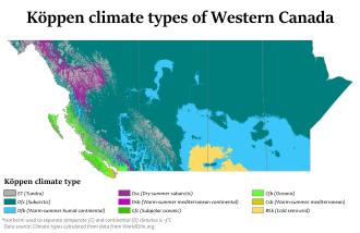
Western Canada Köppen.svg - Redtitan

Prairie Provinces Köppen.svg - Redtitan

Canada Köppen.svg - Getsnoopy

Map of Canada by state's vehicle inspection laws.svg - Iazyges

Canada Federal Ridings Map.svg - DrRandomFactor

Vicariat du Canada.svg - Arcyon37

Canadian provinces and territories by HDI (2015).svg - Allice Hunter

Can Provinces by life expectancy (2015).svg - Allice Hunter

Can Provinces by Average Educational Attainment Index (2015).svg - Allice Hunter

Can Provinces by Expectation of Average Educational Attainment Index (2015).svg - Allice Hunter

Can Provinces by Annual growth of education level 2000-2015.svg - Allice Hunter

Senate of Canada - Seating Plan By Province.svg - MikkelJSmith2

Canada Location Map (2017) with Yellowknife and Saskatoon.svg - Allice Hunter

Quebec-Windsor Corridor 2017.svg - Awmcphee

Poverty in Canadian Provinces.svg - Allice Hunter

Manitoba in Canada (modern).svg - Allice Hunter

Newfoundland and Labrador in Canada (modern).svg - Allice Hunter

New Brunswick in Canada (modern).svg - Allice Hunter

Northwest Territories in Canada (modern).svg - Allice Hunter

Nunavut in Canada (modern).svg - Allice Hunter

Ontario in Canada (modern).svg - Allice Hunter

Saskatchewan in Canada (modern).svg - Allice Hunter

Yukon in Canada (modern).svg - Allice Hunter

Canada location map (modern).svg - Allice Hunter

Major habitat type CAN.svg - Themightyquill

Population density per province by Canada gradient map (2016).svg - MarginalCost

Percent Christians per Canadian Province gradient map (2011).svg - MarginalCost

Percent Irreligious per Canadian Province gradient map (2011).svg - MarginalCost

Can Provinces by Poverty.svg - Allice Hunter

Baffin Bay, Canada-ar.svg - باسم

Thornhill Locator Map.svg - Nat

Territories (43rd parl).svg - RA0808

Political map of Canada.svg - Druiz002

Carte Politique du Canada.svg - Lalpino

Political map of Canada-ang.svg - Hogweard

Canadian provinces and territories by HDI (2018).svg - Allice Hunter

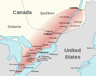
Quebec-Windsor Corridor-fixed-st-hyacinthe.svg - Maximevaillancourt

Canada Missing New Brunswick.svg - Nichard23

Canada, tarification du carbone par province.svg - Dirac

Inuit Nunangat map.svg - Fenn-O-maniC

Nunatsiavut location map.svg - Fenn-O-maniC

Webster-Ashburton treaty map-en.svg - Koavf

Canadian provinces and territories by HDI (2019).svg - Allice Hunter

Regions of Canada for House of Commons ridings (2021).svg - Erinthecute

Sénat du Canada - Répartition des sénateurs par province.svg - AndréLegault

Canada Köppen-ru.svg - Pacha Tchernof

Can Provinces by Population Growth Rate.svg - Tcr25

Canada provinces and territories by population.svg - Tcr25

Population density per province by Canada gradient map (2021).svg - Tcr25

Percent Christians per Canadian Province gradient map (2021).svg - WanukeX

Canadian provinces and territories by GDP (2021).svg - Allice Hunter

Indigenous population by census division.svg - Kingofthedead

Visible minority identity by census division.svg - Kingofthedead

Anglo American War 1812 Locations map-ar.svg - Sgh45

Quebec-Windsor Corridor 1.svg - Itooksomepics

Quebec-Windsor Corridor 2.svg - Itooksomepics

Canada Female Premiers & Prime Ministers Map.svg - Arctic.gnome

Canada Election 2025 Results Map.svg - Zinderboff

Canada 2025 Federal Election seats per province.svg - Furfur