Wikimedi'Òc
Modes d'emploi

Cet album fait partie des albums
Cet album photos contient les sous-albums suivants :


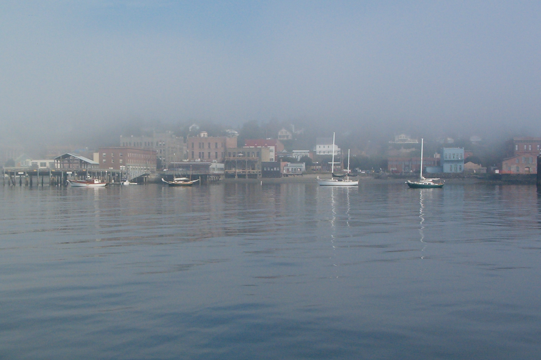
Port Townsend Washington fog waterfront.jpeg - Cdc~commonswiki

PugetSoundNavalShipyardWideView.jpg - Mattes

Bainbridge Island Harbor WA.jpg - Jonesey

Deep-water ports on North America's west coast, connected to the rail grid.png - Geo Swan
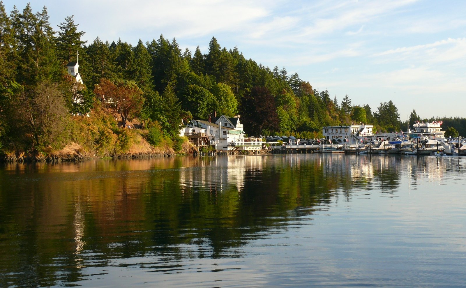
Roche Harbor - San Juan County WA.jpg - Jonesey
Wooden ship built for United States Shipping Board Emergency Fleet Corporation, by Pacific American Fisheries, Bellingha - NARA - 533163.tif - US National Archives bot

LOGS RAFTED ON HARBOR AT EVERETT - NARA - 552132.jpg - US National Archives bot

LOGS FOR JAPAN - NARA - 552148.jpg - US National Archives bot

LOGS FOR JAPAN - NARA - 552149.jpg - US National Archives bot

THEY FOUND OIL AT THE EVERETT HARBOR - NARA - 552150.jpg - US National Archives bot

LOGS BEING LOADED ABOARD SHIP FOR EXPORT TO JAPAN - NARA - 552303.jpg - US National Archives bot

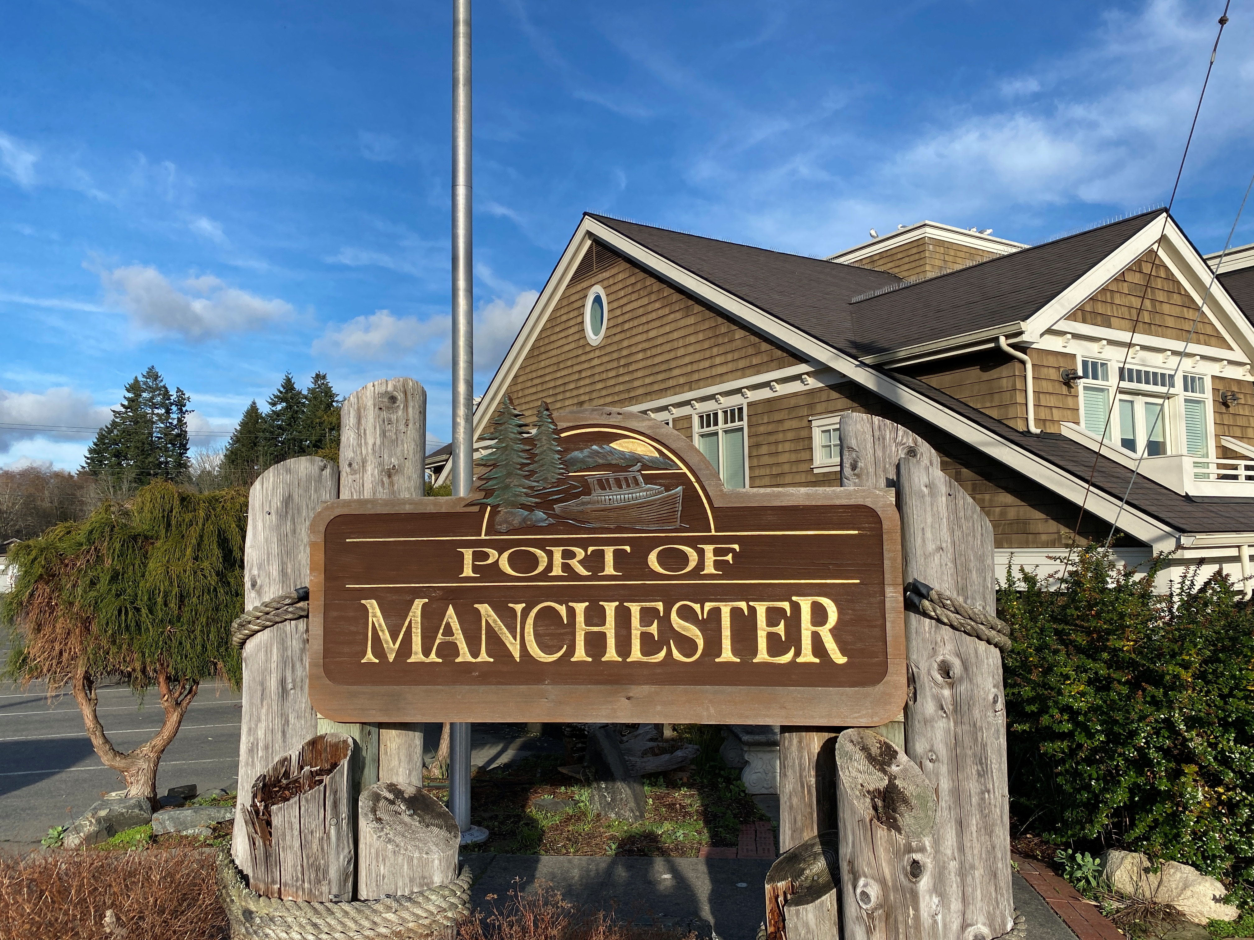
Kingston, WA - Port of Kingston sign 01.jpg - Jmabel

Boats in Gig Harbor.jpg - Holav

Port of Longview (17982528969).jpg - Tony Webster

Waterways from the City Hall, Tacoma, Washington, ca 1919 (BAR 296).jpeg - BMacZeroBot

Purse seiners in the harbor at Richardson, Lopez Island, Washington, ca 1914 (COBB 98).jpeg - BMacZeroBot

Port Ludlow sawmill, Washington, ca1900 (HESTER 12).jpeg - BMacZero

Admiral Jack Foot Ferry.jpg - Lumpytrout

Port of Hoodsport - panoramio.jpg - Panoramio upload bot

Port of Olympia.jpg - Embedded Data Bot

Panorama of the Puget Sound Mills and Timber Co, Port Angeles (CURTIS 61).jpeg - BMacZeroBot

Port Angeles waterfront, from Laurel St to Railroad Ave showing fill at Francis St, 1914 (CURTIS 73).jpeg - BMacZeroBot

Port Angeles, 1914 (CURTIS 74).jpeg - BMacZeroBot

Puget Sound Mills and Timber Co lumber mill, Port Angeles, 1914 (CURTIS 93).jpeg - BMacZeroBot

Seattle waterfront looking southwest from bluff near 1st Ave and Union St (CURTIS 139).jpeg - BMacZeroBot

Panorama of Bremerton and Puget Sound Navy Yard (CURTIS 276).jpeg - BMacZeroBot

Panorama of Bremerton and Puget Sound Navy Yard (CURTIS 277).jpeg - BMacZeroBot

Panorama of Bremerton and Puget Sound Navy Yard (CURTIS 278).jpeg - BMacZeroBot

Panorama of Bremerton and Puget Sound Navy Yard (CURTIS 279).jpeg - BMacZeroBot

Panorama of Puget Sound Navy Yard, Bremerton (CURTIS 280).jpeg - BMacZeroBot

Port Angeles panorama (CURTIS 358).jpeg - BMacZeroBot

Port Angeles viewed from the top of the hill (CURTIS 827).jpeg - BMacZeroBot

McNeil Island Penitentiary (CURTIS 873).jpeg - BMacZeroBot

Tacoma Mill Co, Old Town district, Tacoma (CURTIS 887).jpeg - BMacZeroBot

Tacoma manufacturing district and tideflats looking east (CURTIS 1034).jpeg - BMacZeroBot

Tacoma manufacturing district and tideflats looking east (CURTIS 1035).jpeg - BMacZeroBot

Tacoma manufacturing district and tideflats looking east (CURTIS 1036).jpeg - BMacZeroBot

Pacific Creosoting Co, Eagle Harbor, Kitsap County (CURTIS 1159).jpeg - BMacZeroBot

Pacific Creosoting Co, Eagle Harbor, Kitsap County (CURTIS 1271).jpeg - BMacZeroBot

Pacific American Fisheries processing plant, Bellingham (CURTIS 1669).jpeg - BMacZeroBot
Seattle from Beacon Hill in 1881 (CURTIS 1265).jpeg - BMacZeroBot

No 27 Harbor Scene, Raymond, Washington (22756445915).jpg - Tyler ser Noche

Roche Harbor, as seen from Hotel De Haro on San Juan Island.jpg - Adam W. Ritchey

Small Harbor (3217176475).jpg - Tyler ser Noche

Washington Pulp and Paper Co view from hill, Port Angeles, 1923 (CURTIS 595).jpeg - BMacZeroBot

Port Townsend, Washington, ca 1885 (WASTATE 180).jpeg - BMacZeroBot

Port Townsend, Washington, ca 1890 (WASTATE 741).jpeg - BMacZeroBot

Eastsound Harbor and boats, Eastsound, Orcas Island, ca 1910s (WASTATE 2644).jpeg - BMacZeroBot

Southwest Harbor from Sucia Island, ca 1890 (WASTATE 2671).jpeg - BMacZeroBot

Port of Everett Cement Dome Taken From the Harbor Side (41057718275).jpg - SounderBruce

View from Ediz Hook towards Port Angeles Knok Studio - Beau Chevassus - Port Angeles.jpg - ReachOutAndTouch

View of Harbor Island, ca 1912 (MOHAI 6276).jpg - BMacZeroBot
Manchester WA sign.png - JLR02
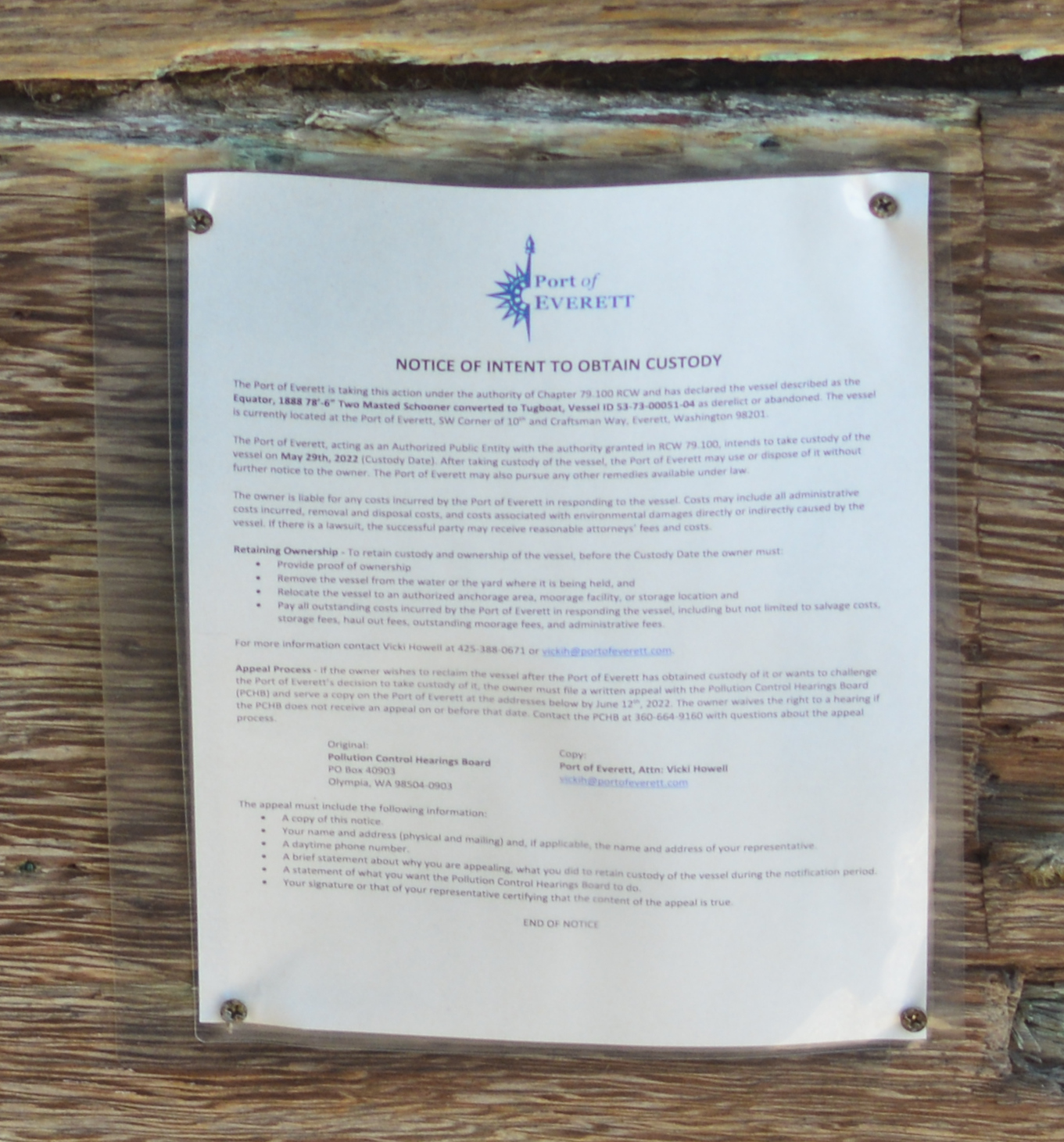
Schooner 'Equator' notice of intent to obtain custody.jpg - Jmabel

Tacoma manufacturing district and tideflats looking east.jpg - Chris Light