Wikimedi'Òc
Modes d'emploi

Cet album fait partie des albums
Cet album photos contient les sous-albums suivants :


Fortyfikacje.jpg - Maksim
FtSumterDrawing.jpg - Junglerot56~commonswiki
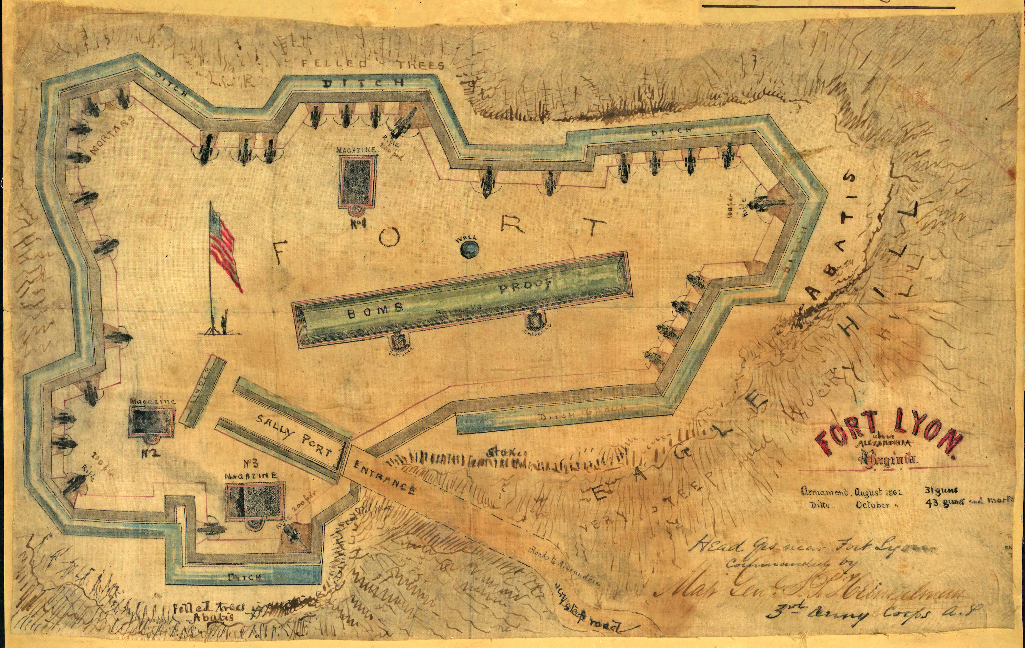
Fort Lyon Diagram.jpg - File Upload Bot (Magnus Manske)

Fotothek df tg 0000258 Geometrie ^ Architektur ^ Festungsbau.jpg - FotothekBot

Fotothek df tg 0000259 Geometrie ^ Architektur ^ Festungsbau.jpg - FotothekBot

Fotothek df tg 0000260 Geometrie ^ Architektur ^ Festungsbau.jpg - FotothekBot

Fotothek df tg 0000262 Geometrie ^ Architektur ^ Festungsbau.jpg - FotothekBot

Fotothek df tg 0000263 Geometrie ^ Architektur ^ Festungsbau.jpg - FotothekBot

Fotothek df tg 0000264 Geometrie ^ Architektur ^ Festungsbau.jpg - FotothekBot

Fotothek df tg 0001883 Architektur ^ Festungsbau.jpg - FotothekBot
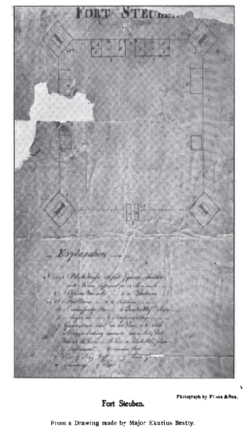
Fort steuben drawing.png - Roseohioresident

Pianta Mollinary tiri interni.jpg - Zambonicorse
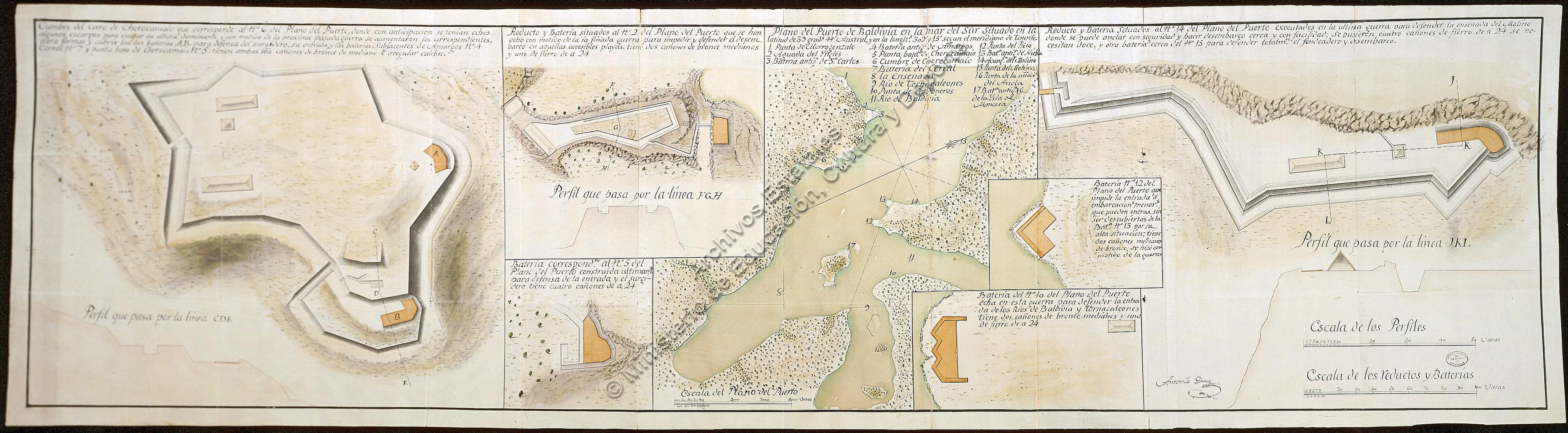
Mapa Valdivia.jpg - Danielduce
BASEMENT PLAN (PHOTOCOPY OF DRAWING) - Governors Island, Fort Columbus, Building No. 214, New York Harbor, New York, New York County, NY HABS NY,31-GOVI,1D-9.tif - Fæ
Unnamed Road, Haiti - panoramio (41).jpg - Panoramio upload bot

Plan of a crémaillère fortification.png - Викидим

Plan for the reconstruction of the fortress of Lendva, 1769.jpg - Szilas

Kerameikos gate complex.svg - Cplakidas

93 of 'Bidrag till Kännedom om Ingermanlands historia och förvaltning, etc' (11246418736).jpg - Artix Kreiger 2

Meyers b6 s0183 b1.png - Mapmarks

Meyers b6 s0184 b1.png - Mapmarks

Meyers b6 s0184 b2.png - Mapmarks

Meyers b6 s0184 b3.png - Mapmarks

Meyers b6 s0185 b1.png - Mapmarks

Meyers b6 s0185 b2.png - Mapmarks

Meyers b6 s0185 b3.png - Mapmarks

Meyers b6 s0186 b1.png - Mapmarks

Meyers b6 s0186 b2.png - Mapmarks

Meyers b6 s0186 b3.png - Mapmarks

Travels in Kurdistan - 3. Hatem Tai Castle (ancient Sisauronon).png - Cplakidas
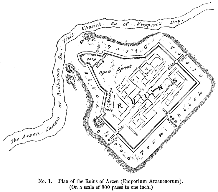
Travels in Kurdistan - 1. Plan of the Ruins of Arzen (Emporium Arzanenorum).png - Cplakidas

Prospect der Europaeischen Kuste und der darauf gelegen Dardanellen und Carte des Canals zwischen Europa und Asien von dem Eingange bey den Dardanellen bis zu Seinem Ausgangen in das Schwarze Meer.jpg - Balkanique

Prospect der Asiatischen Kuste und der beyden auf solcher gelenegen Dardanellen und Perspectivische Einsicht in den Canal der Dardanellen gegen das Meer von Marmora und Constantinopel.jpg - Balkanique

The plan of the fortress Vladikavkaz and the Ingush village of Zaur (1784).jpg - Adam-Yourist

Stadtbefestigung Gmünd in Kärnten.png - Nebulon42

1724 medal of Malta fortress.jpg - Hispalois

Hladový vrch výkres pozorovatelny.jpg - Fry72

Burg Gmünd.png - Nebulon42

Nova Palmae civitas in patria Foroiuliensi ad maris Adriatici ostium contra Barbarorum incursum à Venetis aedificata - btv1b53170372k (2 of 3).jpg - Enyavar

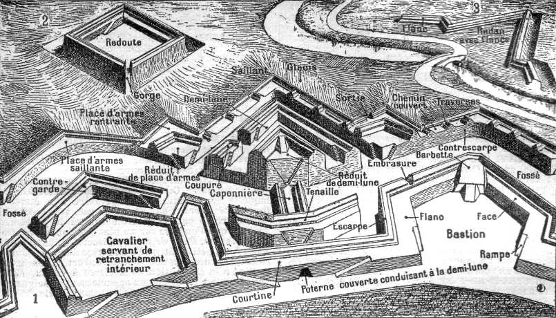
Carte educatif de geometrie des fortifications.jpg - Enyavar

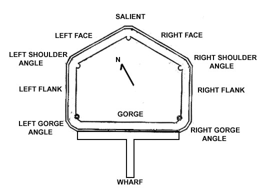
Carte educatif des fortifications et sièges.jpg - Enyavar

Meyers b6 s0185 b4.png - Mapmarks

Kerameikos gate complex-ru.svg - Пётр Тарасьев

Figura 2 Fuerte 4 lados.png - Justinoguerra
Detalle Reducto.png - Justinoguerra

117 Centre d'Interpretació del Castell de Montjuïc, plànol del castell al segle XVIII.jpg - Enric

Map of the plan, section, and elevation of a proposed sarai (resting place) for Bahawalpur Road (F07-03).jpg - MaplesyrupSushi