Wikimedi'Òc
Modes d'emploi

Cet album fait partie des albums
Cet album photos contient les sous-albums suivants :


Varve1.gif - Kbh3rd

Bruce-Trail-bmountain.jpg - File Upload Bot (Magnus Manske)

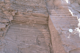
Mica Bay shore 1.JPG - Fungus Guy
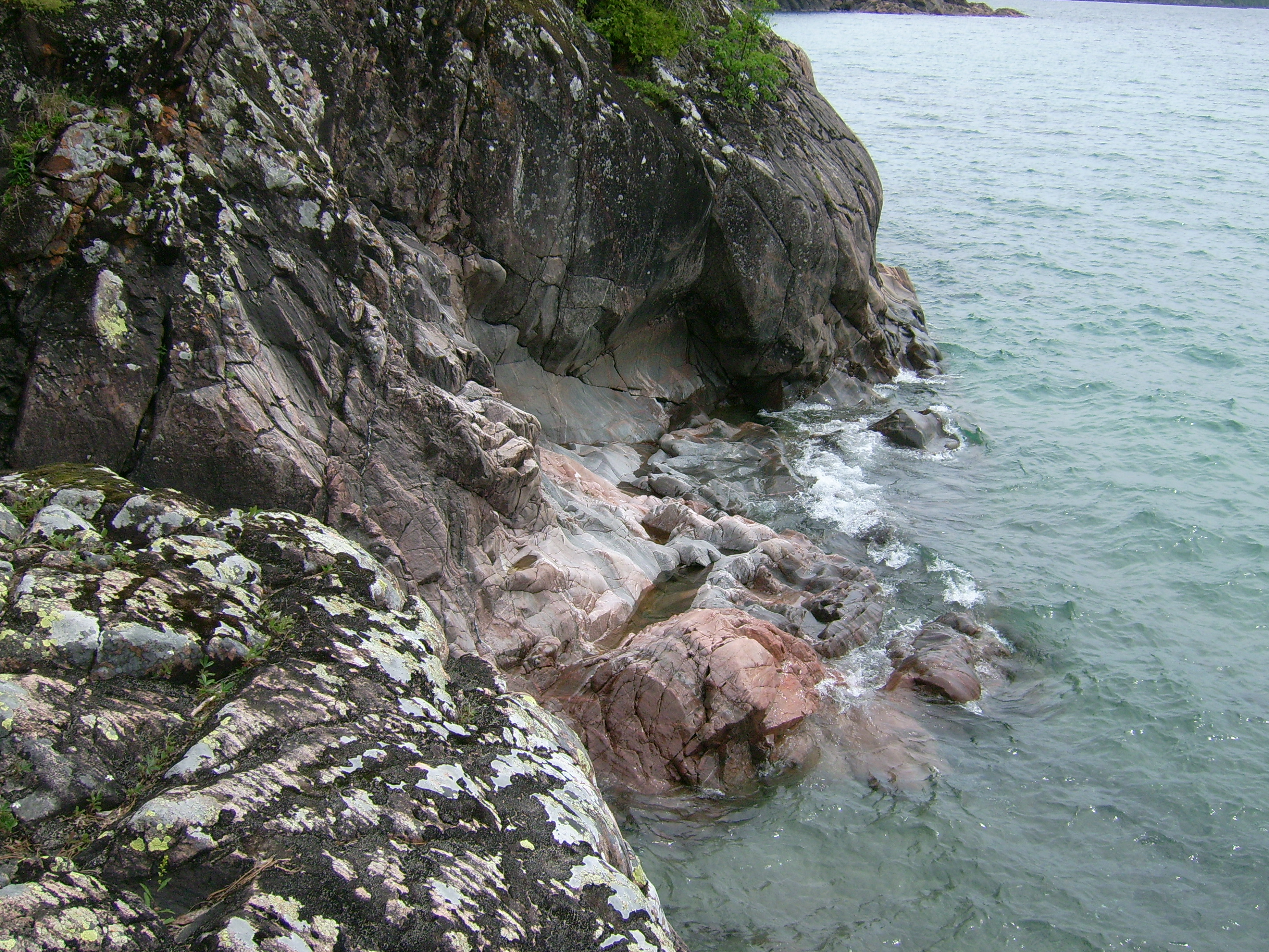
Mica Bay shore 8.JPG - Fungus Guy

Blue Mountain, Charleston Lake Provincial Park, Ontario.jpg - Petersent

Annual report (1913) (14594501040).jpg - Fæ

Sudbury suevite.jpg - Toolguy8

Bedding contact.jpg - HAAldred
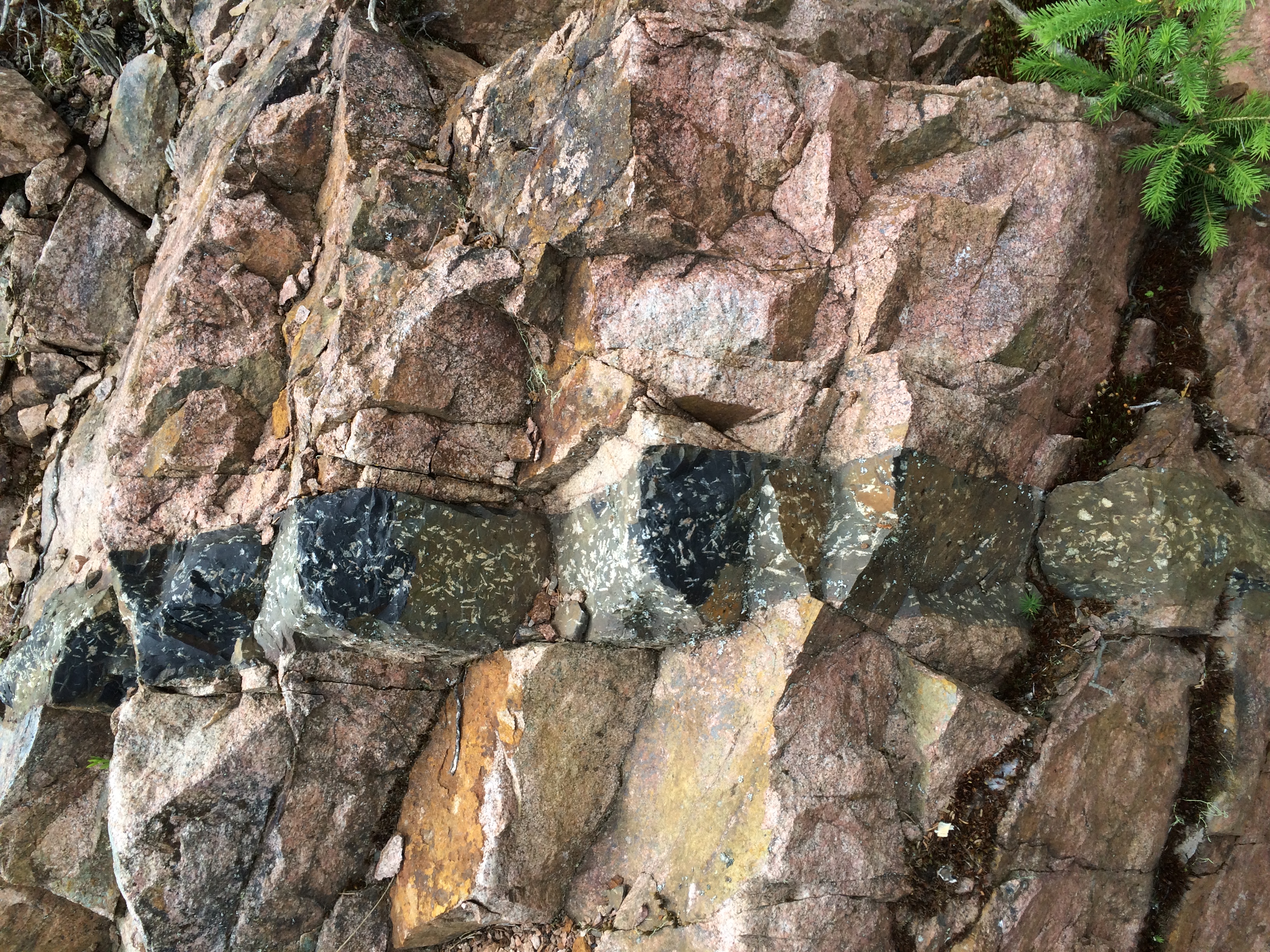
Intrusive dike..jpg - HAAldred

Lamprophyre with xenolith (Dubreuilville Dike, Archean; Route 17 roadcut southeast of Princess Lake & north of Wawa, Ontario, Canada) 26.jpg - Netha Hussain

Xenolith in monchiquite lamprophyre dike (Precambrian; Michipicoten River Bridge South roadcut, south of Wawa, Ontario, Canada) 1 (47926949242).jpg - Ser Amantio di Nicolao

Xenolith in monchiquite lamprophyre dike (Precambrian; Michipicoten River Bridge South roadcut, south of Wawa, Ontario, Canada) 2 (47926945627).jpg - Ser Amantio di Nicolao

Banded iron formation (Temagami Iron-Formation, Neoarchean, ~2.736 Ga; Temagami North roadcut, Temagami, Ontario, Canada) 115 (46882885955).jpg - Ser Amantio di Nicolao

Quartzite & pebbly quartzite with jasper (Lorrain Formation, Paleoproterozoic, ~2.3 Ga; Ottertail Lake Northeast roadcut, near Bruce Mines, Ontario, Canada) 4 (40742683703).jpg - Ser Amantio di Nicolao

Radioactive quartz-pebble conglomerate (Matinenda Formation, Paleoproterozoic, ~2.3-2.48 Ga; Spine Road outcrop, Elliot Lake, Ontario, Canada) 10 (32775870497).jpg - Rudolphous

Radioactive quartz-pebble conglomerate (Matinenda Formation, Paleoproterozoic, ~2.3-2.48 Ga; Spine Road outcrop, Elliot Lake, Ontario, Canada) 18 (46802919835).jpg - Rudolphous

Radioactive quartz-pebble conglomerate (Matinenda Formation, Paleoproterozoic, ~2.3-2.48 Ga; Spine Road outcrop, Elliot Lake, Ontario, Canada) 44 (47666508982).jpg - Rudolphous

Background radiation reading (Spine Road outcrop, Elliot Lake, Ontario, Canada) (47669737432).jpg - Rudolphous

Glacially-smoothed tillite outcrop (Coleman Member, Gowganda Formation, Paleoproterozoic, ~2.3 Ga; Straight Lake West roadcut, north of Temagami, Ontario, Canada) (40859882583).jpg - Rudolphous

Dikes intruding tillite (Nipissing Diabase & Gowganda Formation, Paleoproterozoic; Percival Lake roadcut, Ontario, Canada) 1 (47727719301).jpg - Rudolphous

Dikes intruding tillite (Nipissing Diabase & Gowganda Formation, Paleoproterozoic; Percival Lake roadcut, Ontario, Canada) 5 (47674747312).jpg - Rudolphous

Dikes intruding tillite (Nipissing Diabase & Gowganda Formation, Paleoproterozoic; Percival Lake roadcut, Ontario, Canada) 20 (47728199861).jpg - Rudolphous

Dikes intruding tillite (Nipissing Diabase & Gowganda Formation, Paleoproterozoic; Percival Lake roadcut, Ontario, Canada) 27 (46811766905).jpg - Rudolphous

Metagraywackes (Chelmsford Formation, Paleoproterozoic, 1.74 Ga; Larchwood North outcrop, Sudbury Impact Structure, Ontario, Canada) 8 (40794740053).jpg - Rudolphous

Metagraywackes (Chelmsford Formation, Paleoproterozoic, 1.74 Ga; Larchwood North outcrop, Sudbury Impact Structure, Ontario, Canada) 28 (46844804165).jpg - Rudolphous

Banded iron-formation over basement rocks (Archean; Route 17 roadcut east of Bridget Lake, south of Wawa, Ontario, Canada) 7 (48263201202).jpg - Ser Amantio di Nicolao

Columnar-jointed komatiite lava flow (Upper Komatiitic Unit, Kidd-Munro Assemblage, Neoarchean, 2.711-2.717 Ga; southwest of the Potter Mine, east of Timmins, Ontario, Canada) 2 (46977768215).jpg - Ser Amantio di Nicolao

Black smoker rocks (sulfidic wad) (Helen Iron-Formation, Neoarchean, 2696-2749 Ma; Sir James Pit, Eleanor Iron Range, Ontario, Canada) 4 (48069867321).jpg - Ser Amantio di Nicolao

Cartier Granite (Neoarchean; 2.642 Ga; Windy Lake Northwest roadcut, Sudbury Impact Structure, Ontario, Canada) 1 (32792315457).jpg - Ser Amantio di Nicolao

Metakomatiite lava flows (Upper Komatiitic Unit, Kidd-Munro Assemblage, Neoarchean, 2.711-2.719 Ga; Pyke Hill, near the Potter Mine, east of Timmins, Ontario, Canada) 22 (47775179692).jpg - Ser Amantio di Nicolao

Metakomatiite lava flows (Upper Komatiitic Unit, Kidd-Munro Assemblage, Neoarchean, 2.711-2.719 Ga; Pyke Hill, near the Potter Mine, east of Timmins, Ontario, Canada) 23 (40860861953).jpg - Ser Amantio di Nicolao

Metakomatiites (Upper Komatiitic Unit, Kidd-Munro Assemblage, Neoarchean, 2.711-2.719 Ga; Pyke Hill, near the Potter Mine, east of Timmins, Ontario, Canada) 3 (46912500215).jpg - Ser Amantio di Nicolao

Metakomatiites (Upper Komatiitic Unit, Kidd-Munro Assemblage, Neoarchean, 2.711-2.719 Ga; Pyke Hill, near the Potter Mine, east of Timmins, Ontario, Canada) 5 (47044176764).jpg - Ser Amantio di Nicolao

Microsyenite dike (Precambrian; Michipicoten River Bridge South roadcut, south of Wawa, Ontario, Canada) 4 (47924612632).jpg - Ser Amantio di Nicolao

Faulted clast in tillite (Coleman Member, Gowganda Formation, Paleoproterozoic, ~2.3 Ga; Straight Lake West roadcut, north of Temagami, Ontario, Canada) 3 (47026270824).jpg - Ser Amantio di Nicolao

Lighthouse Point gneiss.jpg - The Cosmonaut

20150705 - 31 - Township of Georgian Bay, Ont. - Northward along Highway 400 - Northlands Preview.jpg - Andre Carrotflower

20150705 - 33 - Seguin, Ont. - Northward along Highway 400 - Northlands Preview No. 2.jpg - Andre Carrotflower

20150705 - 87 - Shawanaga No. 17, Ont. - Outcroppings Along Highway 69.jpg - Andre Carrotflower

20150706 - 06 - Sudbury, Ont. - Shopping Plaza + Rock Outcropping.jpg - Andre Carrotflower

20150706 - 17 - Sudbury, Ont. - Walls (Of Rock and Otherwise) at Laurentian University.jpg - Andre Carrotflower

20150706 - 35 - Walden, Sudbury, Ont. - Outcroppings Along Highway 17.jpg - Andre Carrotflower

20150706 - 41 - Espanola, Ont. - Majesty of the North.jpg - Andre Carrotflower

20150706 - 45 - The North Shore, Ont. - Outcroppings Along Highway 17.jpg - Andre Carrotflower

20150708 - 04 - Unorganized North Algoma District, Ont. - Outcroppings along Highway 17.jpg - Andre Carrotflower

20150708 - 07 - Unorganized North Algoma District, Ont. - More outcroppings along Highway 17.jpg - Andre Carrotflower

20150708 - 11 - Lake Superior Provincial Park, Ont. - Wall of outcropped rock along Highway 17.jpg - Andre Carrotflower

20150708 - 20 - Unorganized North Algoma District, Ont. - Outcroppings along Highway 17 - "The Smallness of Man".jpg - Andre Carrotflower

20150708 - 22 - White River, Ont. - Outcroppings along Highway 17.jpg - Andre Carrotflower

20150708 - 44 - Pukaskwa National Park, Ont. - Southern Headland Trail - "Stand in the Corner".jpg - Andre Carrotflower

20150708 - 55 - Pukaskwa National Park, Ont. - "Right-Angle Rock".jpg - Andre Carrotflower

20150708 - 65 - Pukaskwa National Park, Ont. - Southern Headland Trail - "Along the Way" No. 6 - Guide Board Road.jpg - Andre Carrotflower

20150708 - 80 - Unorganized Thunder Bay District, Ont. - Outcroppings along Highway 17 - "Red Road".jpg - Andre Carrotflower

20150708 - 83 - Schreiber, Ont. - Outcroppings along Highway 17 - "Dead Man's Curve".jpg - Andre Carrotflower

20150708 - 86 - Unorganized Thunder Bay District, Ont. - Rock walls along Highway 17 - "Deep Cut".jpg - Andre Carrotflower

Old Baldy Conservation Area- Iconic Outcrop of Hard Amabel Dolostone Caprack-Gray County-Ontario-20210919.jpg - Mhsheikholeslami