Wikimedi'Òc
Modes d'emploi

Cet album fait partie des albums
Cet album photos contient les sous-albums suivants :


Meyers b17 s0705a.jpg - Mapmarks

AmCyc Germany.jpg - Library Guy

Europe since 1815 (1910) (14578192679).jpg - Fæ

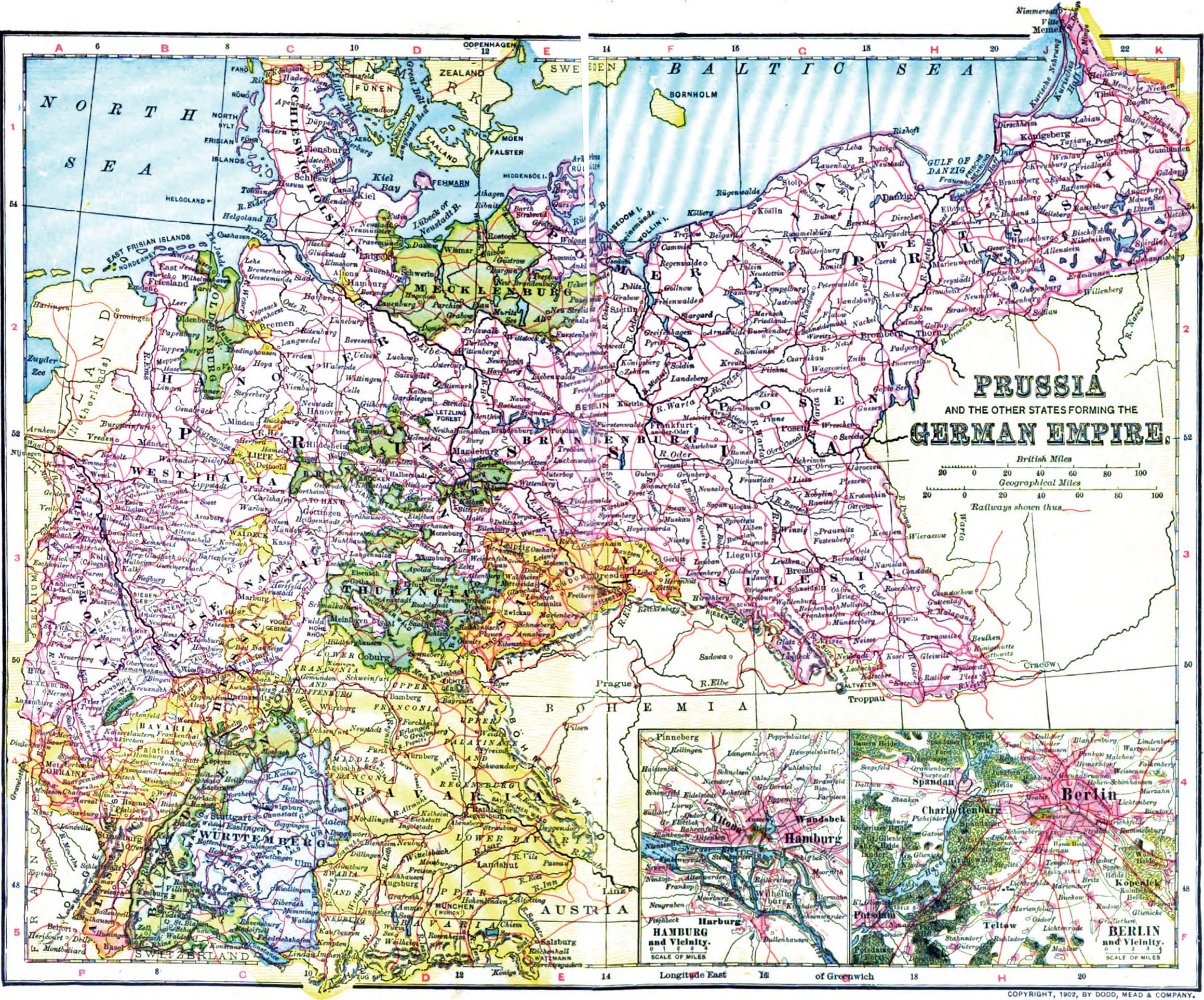
Meyers b18 s0495a.jpg - Mapmarks
Meyers b18 s0515a.jpg - Mapmarks
Meyers b18 s0533a.jpg - Mapmarks

Atlas of European history (1909) (14597350238).jpg - SteinsplitterBot

Kelly Miller's history of the world war for human right; being an intensely human and brilliant account of the world war and why and for what purpose America and the allies are fighting and the (14595493338).jpg - SteinsplitterBot

The modern world, from Charlemagne to the present time; with a preliminary survey of ancient times (1919) (14594475300).jpg - Fæ

The modern world, from Charlemagne to the present time; with a preliminary survey of ancient times (1919) (14758188376).jpg - Fæ

Germany (1883) (14768036554).jpg - Fæ

Germany (1883) (14768016624).jpg - Fæ

The Americana; a universal reference library, comprising the arts and sciences, literature, history, biography, geography, commerce, etc., of the world (1908) (14596439009).jpg - SteinsplitterBot

Brockhaus' Konversations-Lexikon (1892) (14758084156).jpg - Fæ

Brockhaus' Konversations-Lexikon (1892) (14777977561).jpg - Fæ

Brockhaus' Konversations-Lexikon (1892) (14780785062).jpg - Fæ

Brockhaus' Konversations-Lexikon (1892) (14777933441).jpg - Fæ

Brockhaus' Konversations-Lexikon (1892) (14778712204).jpg - Fæ

Modern history; Europe (1904) (14579193919).jpg - Fæ
A brief history of the nations and of their progress in civilization (1896) (14595788458).jpg - Fæ

A brief history of the nations and of their progress in civilization (1896) (14595759179).jpg - Fæ

Diccionario enciclopedico hispano-americano de literatura, siencias y artes. Edicion profusamente ilustrada con miles de pequeños grabados intercalados en el texto y tirados aparte, que reproducen las (14763093882).jpg - SteinsplitterBot

EB1911 Germany - geological map.jpg - DivermanAU

EB1911 Germany.jpg - DivermanAU
Die deutsche Seegrenze (Östlicher Teil).tif - Lucius Castus
Die deutsche Seegrenze (Westlicher Teil).tif - Lucius Castus

Image taken from page 111 of 'Deutschlands Kolonien. Kurze Beschreibung von Land und Leuten unserer aussereuropäischen Besitzungen ... Mit ... Abbildungen und einer Übersichtskarte, etc. (Edited by G. Wende.)' (11201780083).jpg - Artix Kreiger 2

571 of 'Die Hohenzollern und das Reich, etc' (11167114713).jpg - FlickreviewR 2

208 of 'The High School Manual of Geography. With maps and illustrations' (11279106703).jpg - Artix Kreiger 2

34 of 'Neumanns Orts-Lexikon des Deutschen Reichs' (11226122855).jpg - Artix Kreiger 2

510 of '(Oliver and Boyd's Pronouncing Gazetteer of the World, descriptive and statistical, with etymological notices, etc.)' (11163542543).jpg - Artix Kreiger 2

511 of '(Oliver and Boyd's Pronouncing Gazetteer of the World, descriptive and statistical, with etymological notices, etc.)' (11162417916).jpg - Artix Kreiger 2

Charte das Deutsche Reich nach seinen Kreisen und deren Unter-abtheilungen vorstellend.jpg - Higgenhorscht

Stieler - Das Deutsche Reich in 4 Blättern, 1911 (composite map).jpg - FDRMRZUSA

Stieler - Das Deutsche Reich in 4 Blättern, 1905 (composite map).jpg - FDRMRZUSA

Il Calamaro o' ’Pesce Diavolo’ Prussiano.jpg - Balkanique
Erdkarte zur Übersicht des Kolonialbesitzes, der Konsularischen und Diplomatischen Vertretungen und der Postdampferlinien des Deutschen Reiches.tif - Balkanique

WWII Anti-Axis Greek Language Propaganda Maps - 08 - The German Empire 1870-1914.jpg - Balkanique

Stanford's map of the German Empire (5003872a).jpg - Jason.nlw

Stanford's map of the German Empire (5003872b).jpg - Jason.nlw
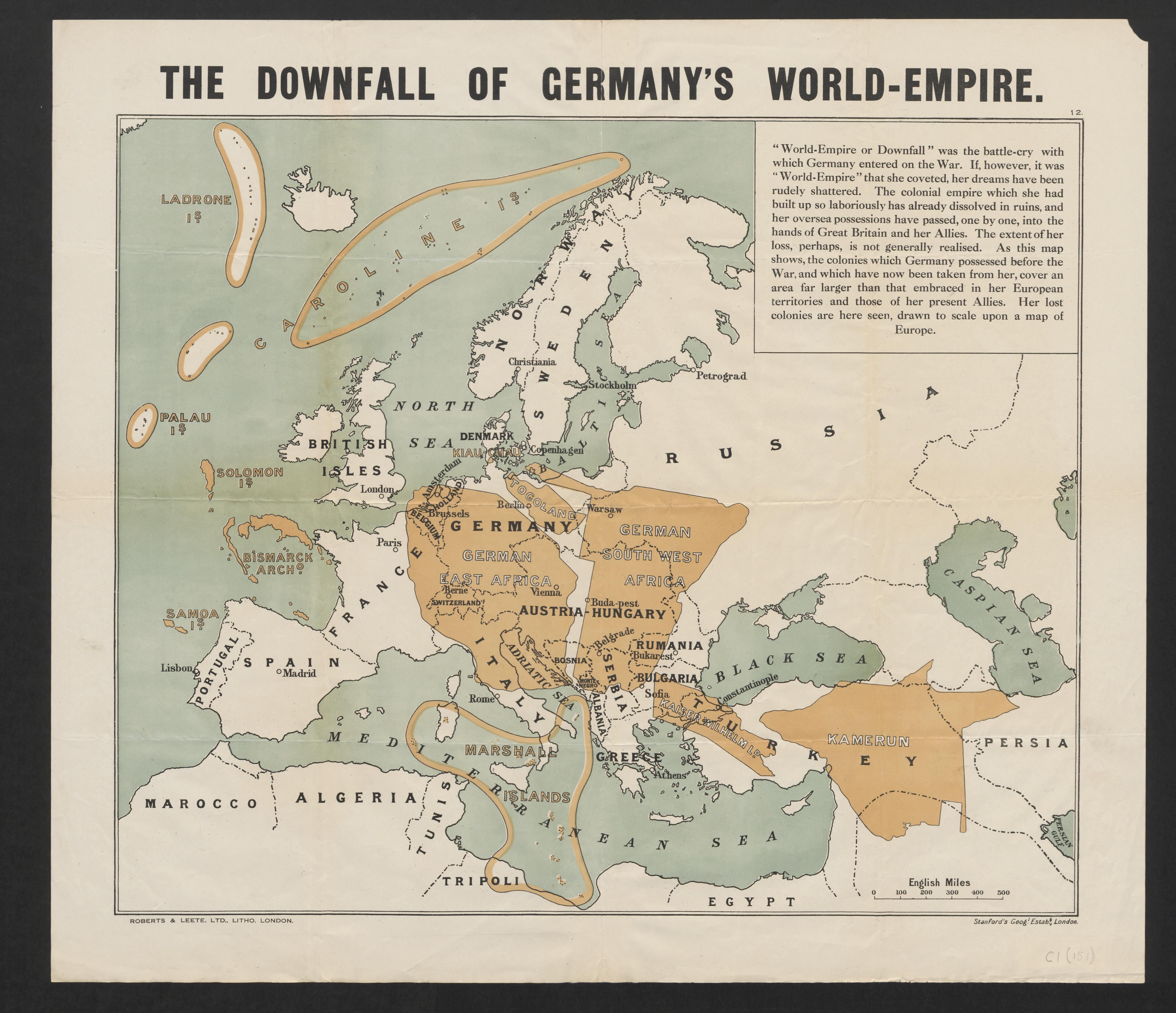
The downfall of Germany's world-empire (5003869).jpg - Jason.nlw
1893 map of Europe and the Middle East showing German consulates (cropped).tif - Balkanique

Empire Allemand en 1887.jpg - Trecătorul răcit

The Harmsworth atlas and Gazetter 1908 (135848976).jpg - Polona Upload

Deutsches Reich, deutsch-österreichische Provinzen und die Schweiz - entworfen u. gezeichnet v. F. Handtke - btv1b530252456.jpg - Gzen92Bot

Prussian State and the German Empire, 1886 (Geographisches Institut, Weimar).jpg - FDRMRZUSA

German Empire and Austro-Hungarian monarchy, 1872 (Meyer).jpg - FDRMRZUSA

Stieler - Das Deutsche Reich in 4 Blättern, 1879 (composite map).jpg - FDRMRZUSA

Stieler - Das Deutsche Reich in 4 Blättern, 1894 (composite map).jpg - FDRMRZUSA

Meyers leiner Hand-atlas 1893 (73136536).jpg - Enyavar

The Collegiate Atlas 1876 (82451227).jpg - Polona Upload

C. 1871 Unification of Germany.jpg - Ty's Commons

C. 1897 German Empire.jpg - Ty's Commons

1914 Eisenbahnkarte-des-Koenigreichs-Sachsen.jpg - Anana Sanana

Dismembered Russia — Some Fragments (NYT article, Feb. 17, 1918).png - MaGioZal
Deutsches Reich Historische Karten 2.jpg - SebastianBreier~commonswiki

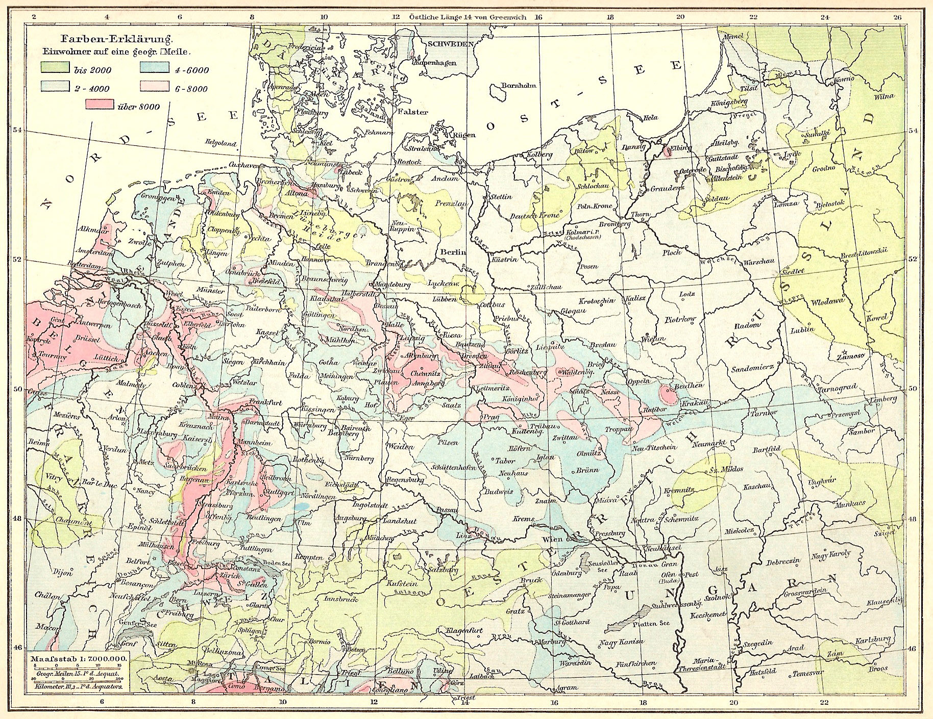
Deutsches Reich Bevölkerungsdichte.jpg - SebastianBreier~commonswiki

Deutsches Reich Bergwerke.jpg - SebastianBreier~commonswiki

Deutsches Reich Konfessionskarte.jpg - SebastianBreier~commonswiki

Deutsches Reich Eisenbahnen.jpg - Drdoht

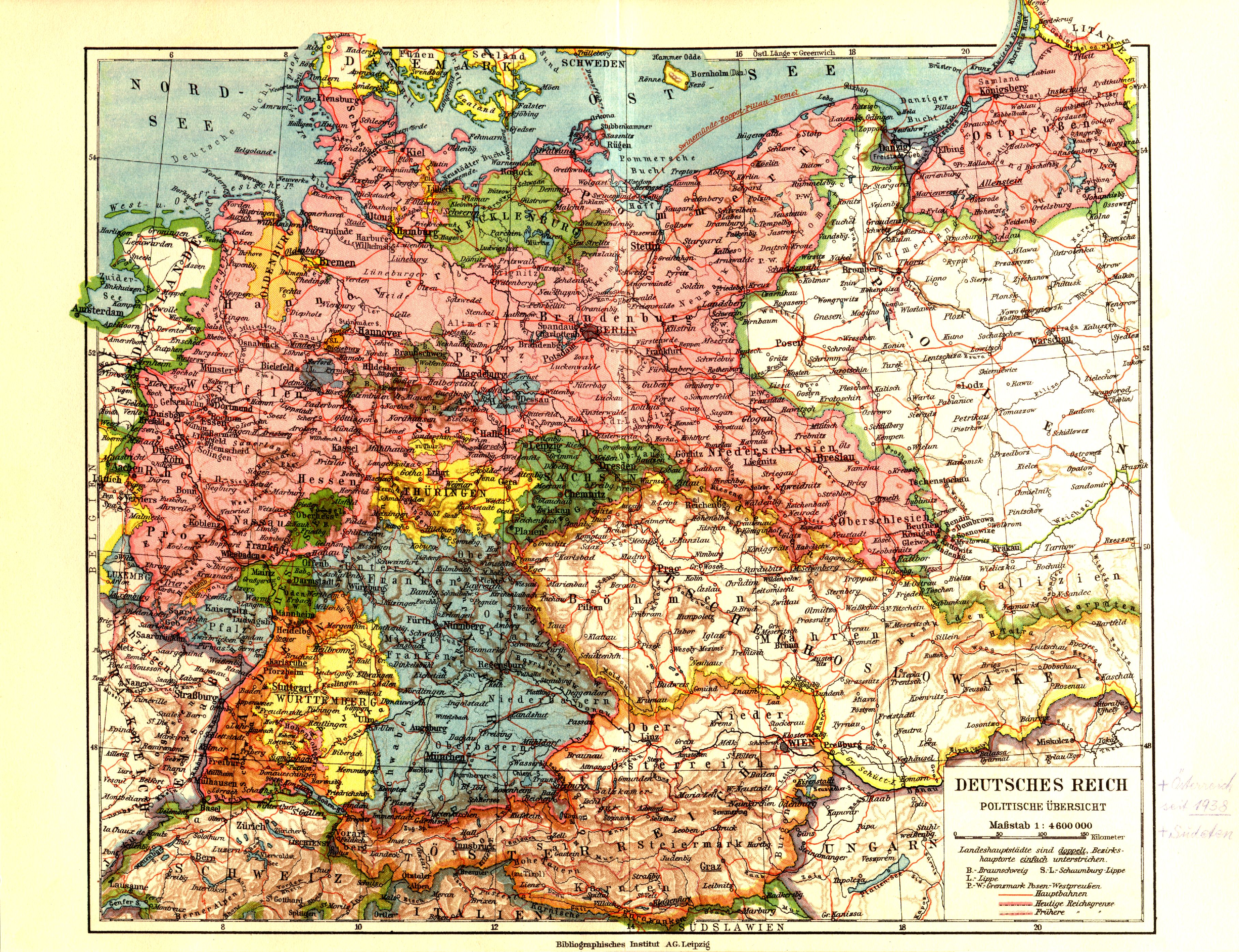
Deutsches Reich Politische Karte.jpg - SebastianBreier~commonswiki

Deutsches Reich Landwirtschaft.jpg - SebastianBreier~commonswiki
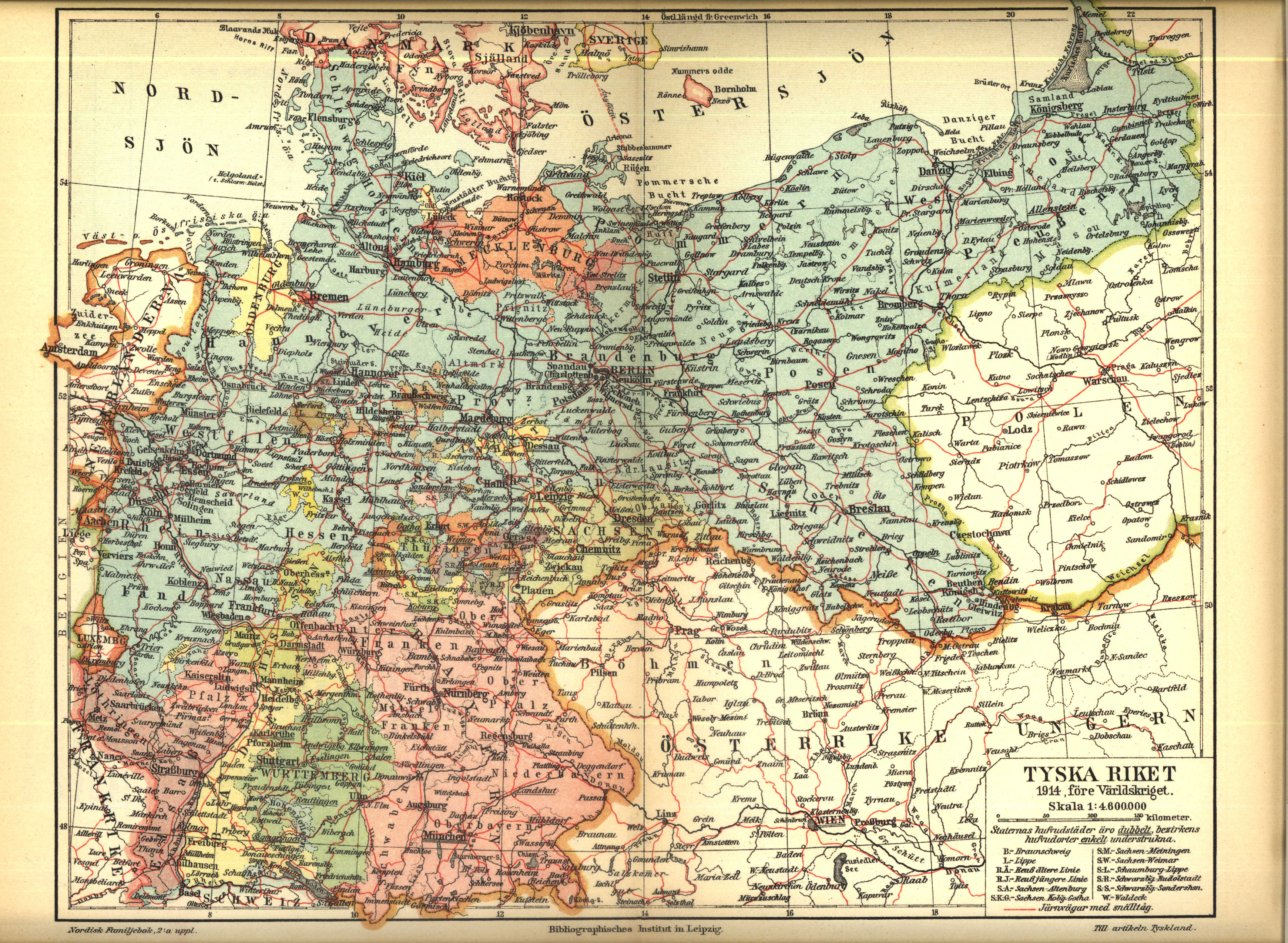
Karta över Tyska riket 1914, före första världskriget (ur Nordisk familjebok).jpg - Den fjättrade ankan~commonswiki

Karta över Tyskland år 1919 enligt Versaillesfreden (ur Nordisk familjebok).jpg - Den fjättrade ankan~commonswiki

Deutsches Kaiserreich 1893.jpg - Alexander Fischer

Ger demands 1915.jpg - Tarawneh

Alleged consp map8 1914.jpg - Tarawneh

Germany future 1917.jpg - Tarawneh

Andree21-2.jpg - Grombo~commonswiki
Andree24-2.jpg - Grombo~commonswiki

Meyers b5 s0442a.jpg - Mapmarks

Ost und Westpreußen.jpg - Cherubino

German unified 1815 1871.jpg - Raymond

Karte Deutsches Reich 1892.jpg - Sidonius

Stielers Handatlas 1891 09.jpg - Kolossos

Stielers Handatlas 1891 10.jpg - Kolossos

Stielers Handatlas 1891 12.jpg - Kolossos

Stielers Handatlas 1891 13.jpg - Kolossos

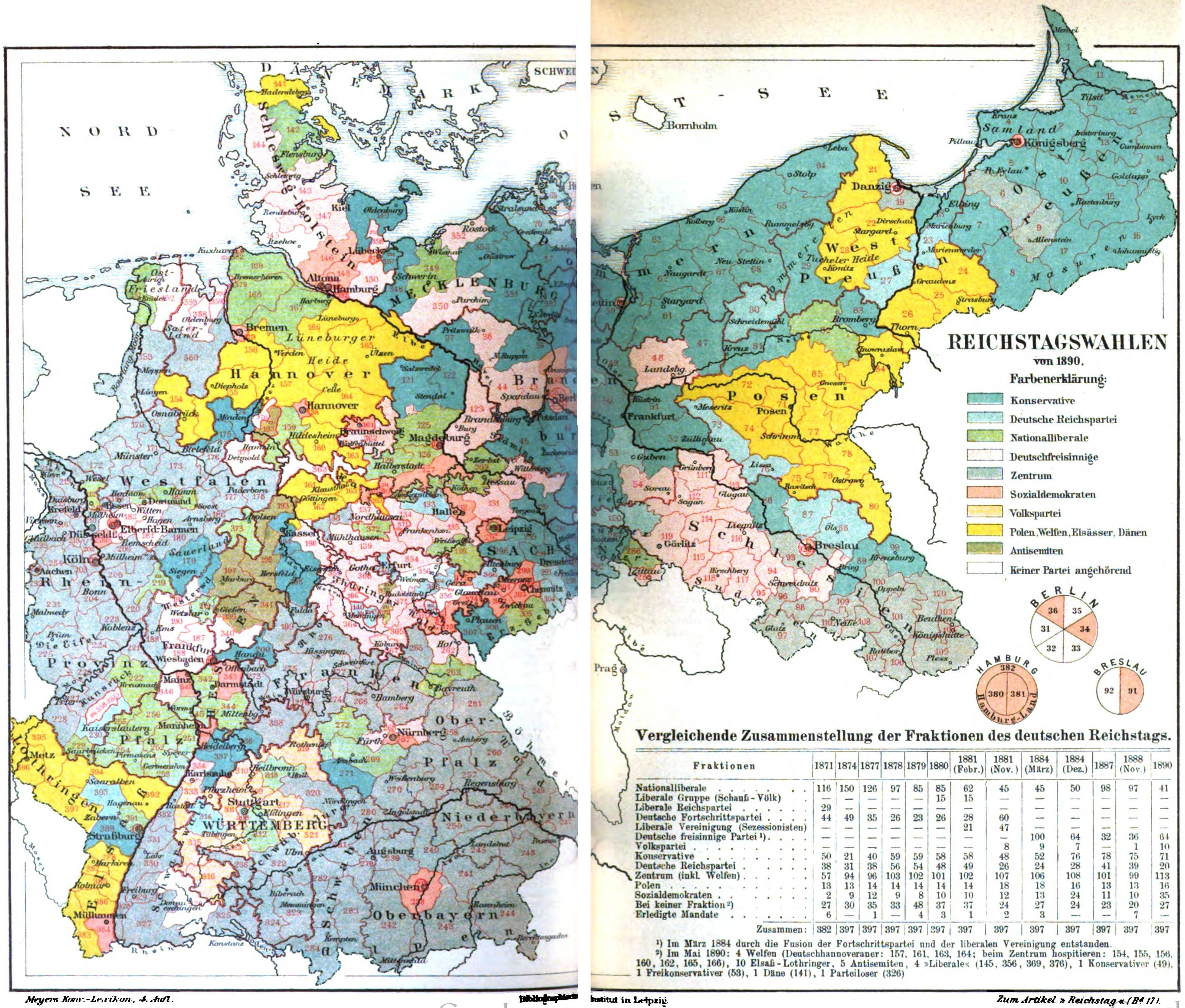
German Reichstag 1898 (in Russian).jpg - Alaexis

London-geographical-institute the-peoples-atlas 1920 russian-battlefronts.jpg - Piotrus

Karte Nordwalde 1883.JPG - Roland Arhelger

Deutsche Korpsbereiche 1914.jpg - Milgesch

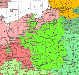
Sprachenkarte Deutschland1880.png - Ras67

Polish language1880.png - Ulamm

Anti-Germanic Barrier in the Balkans in 1914.jpg - Tarawneh
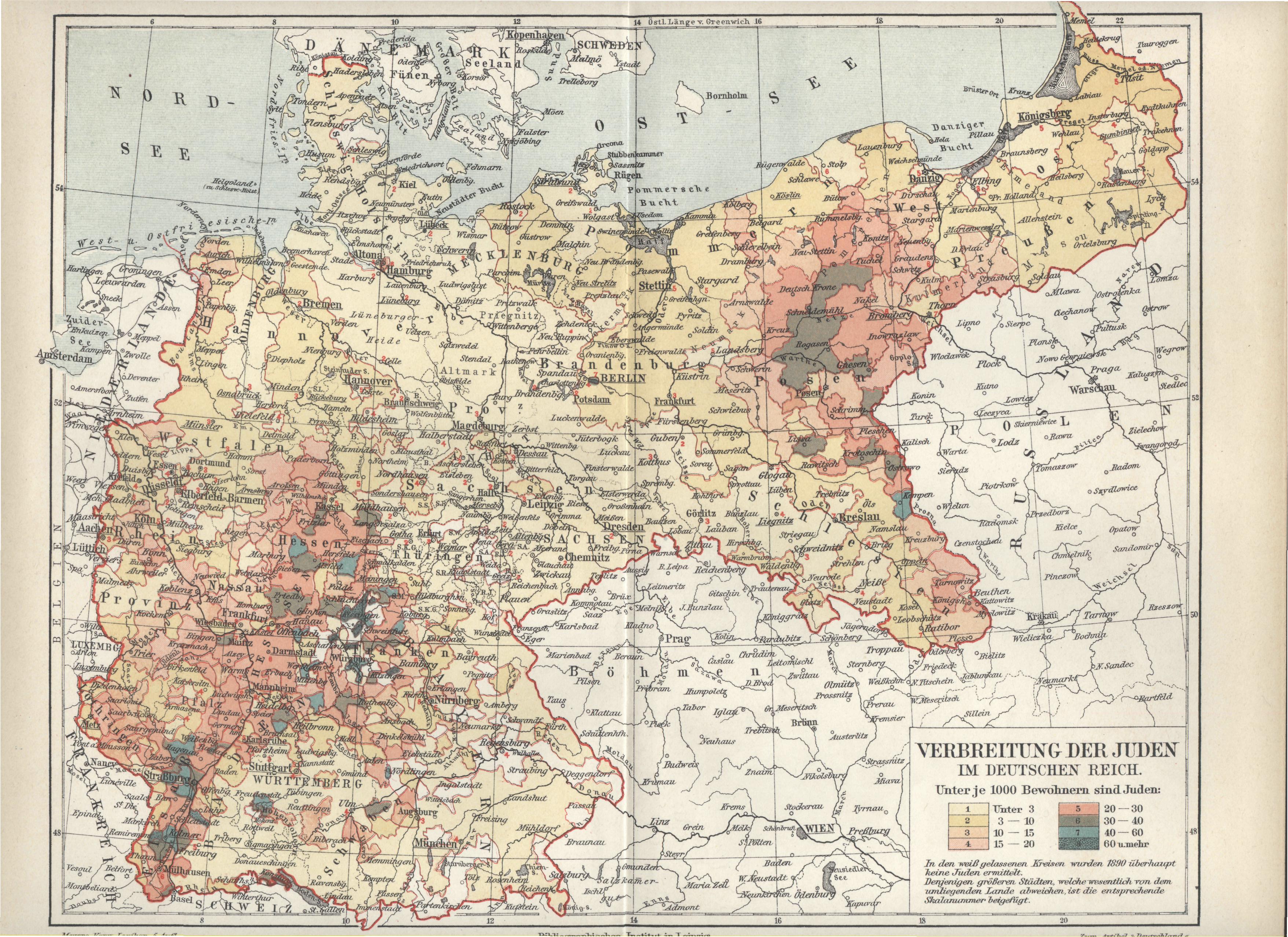
Verbreitung der Juden im deutschen Reich.jpg - Mahagaja
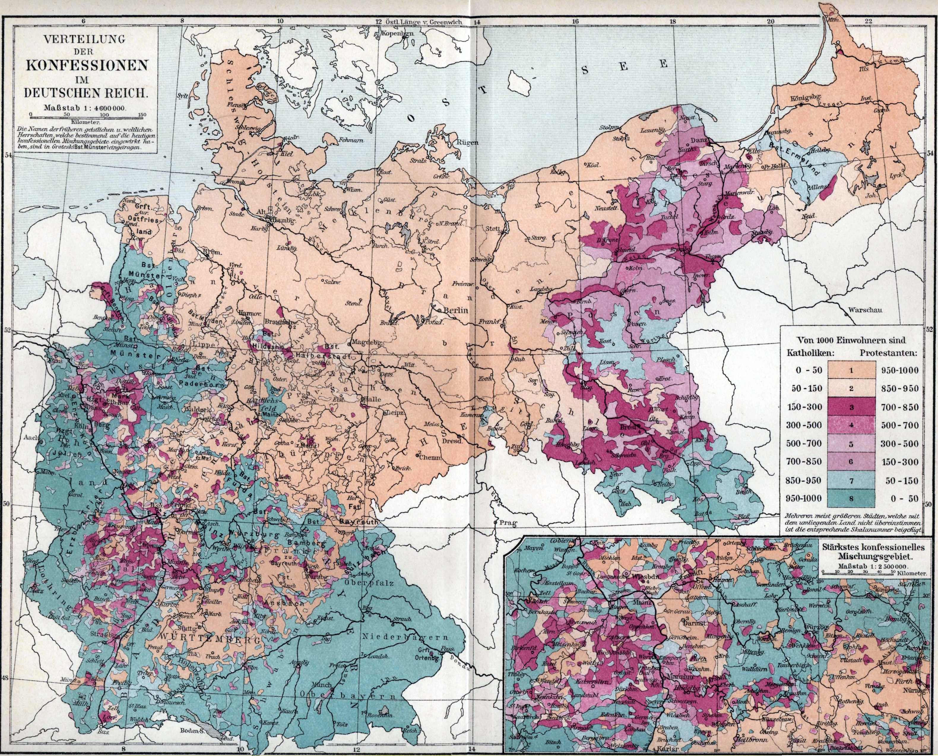
Verbreitung der Konfessionen im deutschen Reich.jpg - DIREKTOR

Reise-bzwEisenbahnkarte Deutschland1896.jpg - Rowan~commonswiki
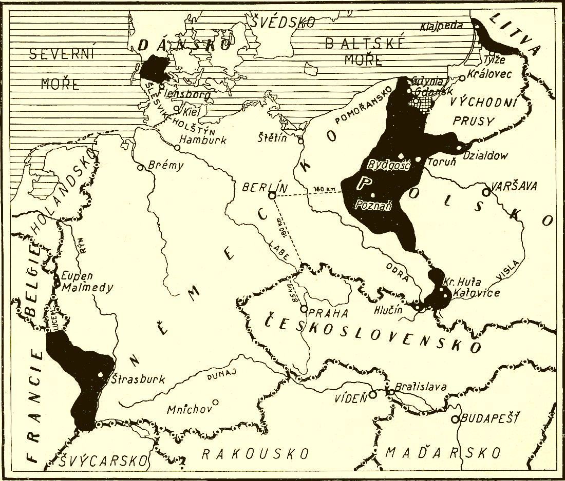
Territorial losses of Germany.jpg - Geographus

Germany 1900.jpg - Sasha Krotov

Karte der Reichstagswahlen 1907.jpg - Chumwa

Bahnkarte Deutschland 1899.jpg - Jom

Karte Seltzlin.jpg - Milgesch

Brockhaus 1894 Deutsche Mundarten.jpg - PhJ

Brockhaus and Efron Encyclopedic Dictionary b16 484-0.jpg - ButkoBot

Brockhaus and Efron Encyclopedic Dictionary b52 520-2.jpg - ButkoBot

Tyskland, Österrike och Tjeckoslovakien (1930).jpg - Wolfgangus Mozart
KglWestEB.jpg - JuTa

Germanempire 1871 english plus language.jpg - File Upload Bot (Magnus Manske)

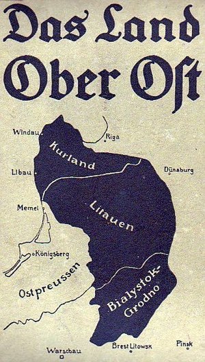
OberOst.jpg - 1970gemini
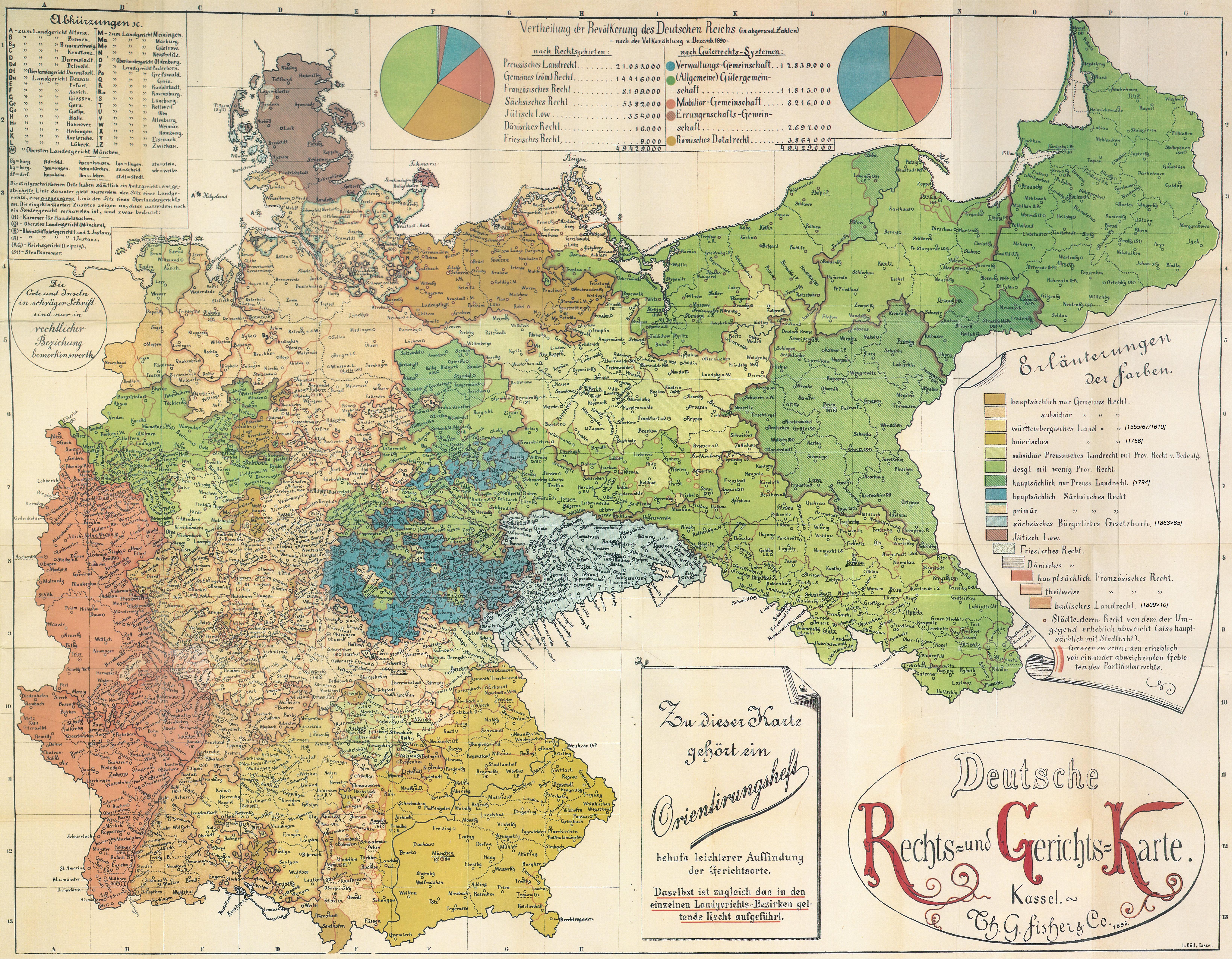
Deutsche Rechts- und Gerichtskarte (1895).jpg - Commonsignore

Die Gartenlaube (1870) b 546.jpg - Joergens.mi

Lamsdorf1930's-Uebungsplatz&Lager 1870-1946.jpg - Julo

Eisenbahnkarte Deutschland 1908-Wm05514a.jpg - Drdoht

Wandkarte von Süd-West-Deutschland.jpg - ComputerHotline

1905 Mayer Wm16744d.jpg - Ziko

Brockhaus 1894 Deutsche Mundarten Sorbisch.jpg - TMg

Rechtsgebiete Deutsches Reich.jpg - Sandstein

Diagram from Chapter 6, Germany's High Seas Fleet in the World War.png - Avantman42

Diagram 2 from Chapter 6, Germany's High Seas Fleet in the World War.png - Avantman42

Diagram 3 from Chapter 6, Germany's High Seas Fleet in the World War.png - Avantman42

Diagram 4 from Chapter 6, Germany's High Seas Fleet in the World War.png - Avantman42

Diagram 5 from Chapter 6, Germany's High Seas Fleet in the World War.png - Avantman42

Diagram 6 from Chapter 6, Germany's High Seas Fleet in the World War.png - Avantman42
Diagram 7 from Chapter 6, Germany's High Seas Fleet in the World War.png - Avantman42

Diagram from Chapter 8, Germany's High Seas Fleet in the World War.png - Avantman42

Diagram 1 from Chapter 9, Germany's High Seas Fleet in the World War.png - Avantman42

Diagram 2 from Chapter 9, Germany's High Seas Fleet in the World War.png - Avantman42

Diagram from Chapter 15, Germany's High Seas Fleet in the World War.png - Avantman42

Diagram 1 from Chapter 17, Germany's High Seas Fleet in the World War.png - Avantman42

Diagram 2 from Chapter 17, Germany's High Seas Fleet in the World War.png - Avantman42

Diagram from Chapter 11, Germany's High Seas Fleet in the World War.png - Avantman42

F. Müllhaupt's Militarische & Verkehrs-Karte der Deutsch-Französischen Grenze...jpg - ComputerHotline
NIE 1905 Germany.jpg - Bob Burkhardt

Reichstagswahlkarte 1898-1903.jpg - Furfur

Reichstagswahlkarte 1893-1898.jpg - Furfur

Meyers b4 s0800a.jpg - Mapmarks

Германия, конец XIX века.jpg - Vvk121
LA2-Blitz-0083.jpg - LA2
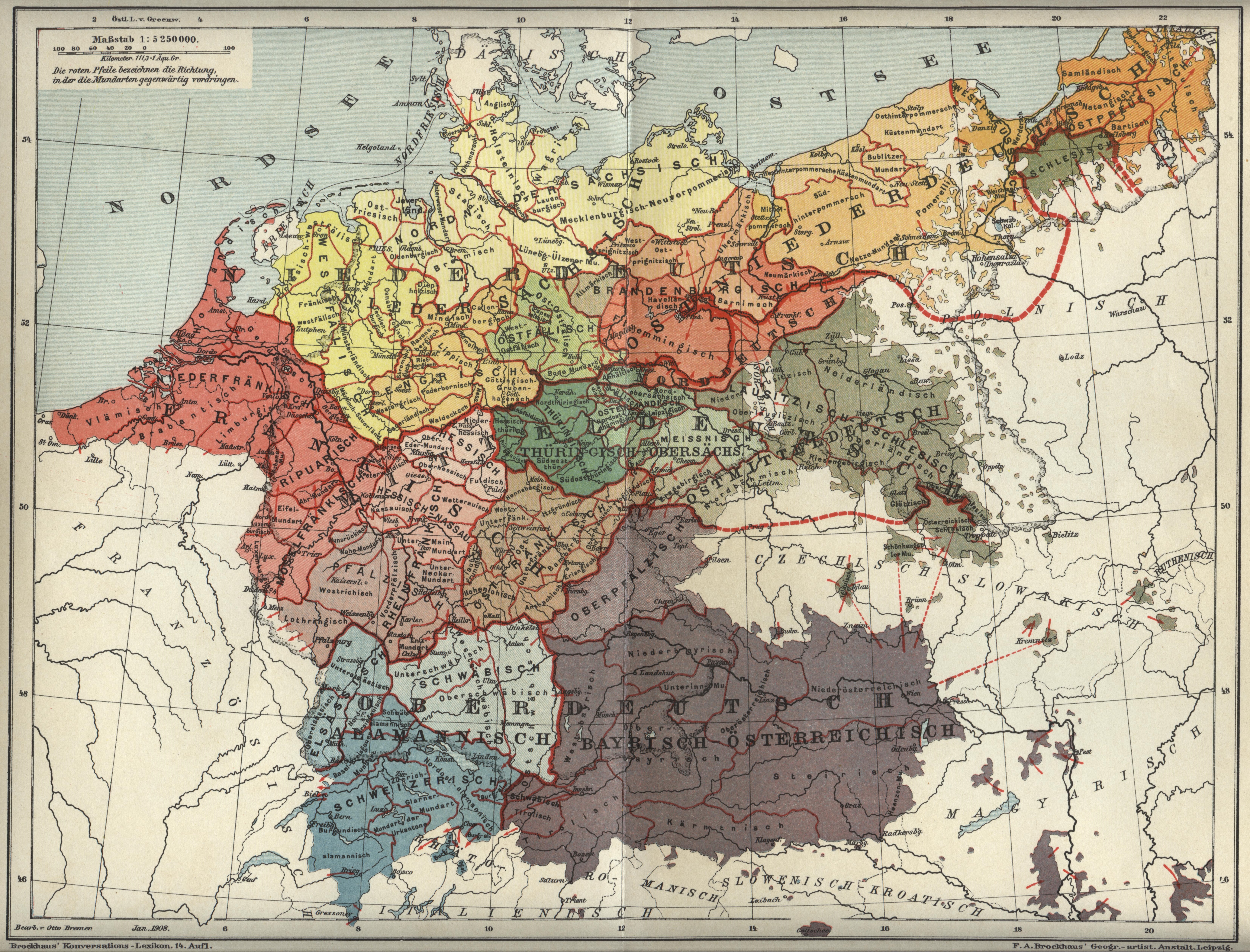
Karte der deutschen Mundarten (Brockhaus).jpg - Oltau

Arbuckle Bros. Coffee Co. (3093823602).jpg - Fæ