Wikimedi'Òc
Modes d'emploi

Cet album fait partie des albums
Cet album photos contient les sous-albums suivants :


Post Roman Balkans.jpg - WikiEditor2004

Balkan Wars Boundaries.jpg - DIREKTOR

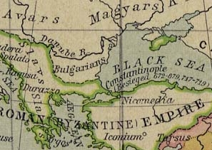
Meyers b3 s0247a.jpg - Mapmarks
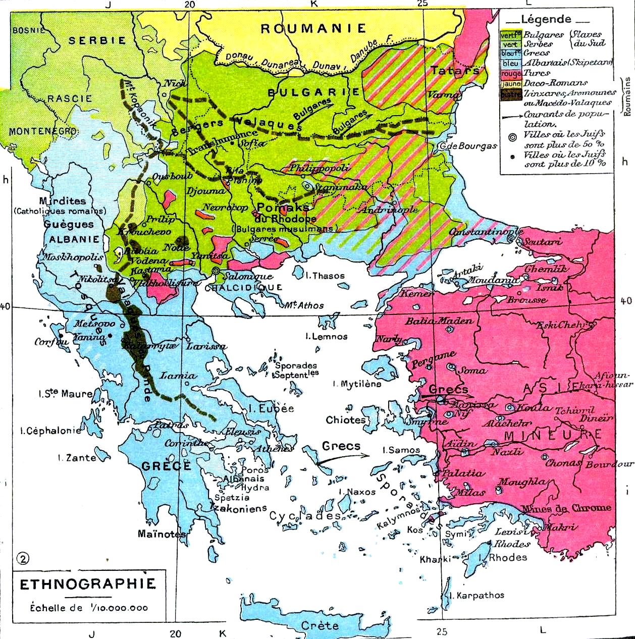
Balkans-ethnique.JPG - Alex:D

Meyers b14 s0024a.jpg - Red Rooster
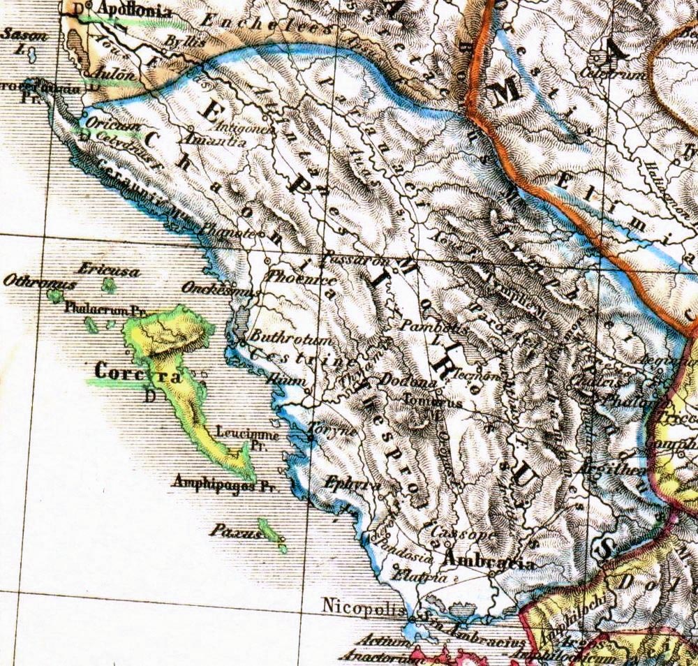
Epirus antiquus tabula.jpg - Hohum
Balkans 750.jpg - Finavon

Balkan Wars Boundaries cleanup.jpg - Pruxo
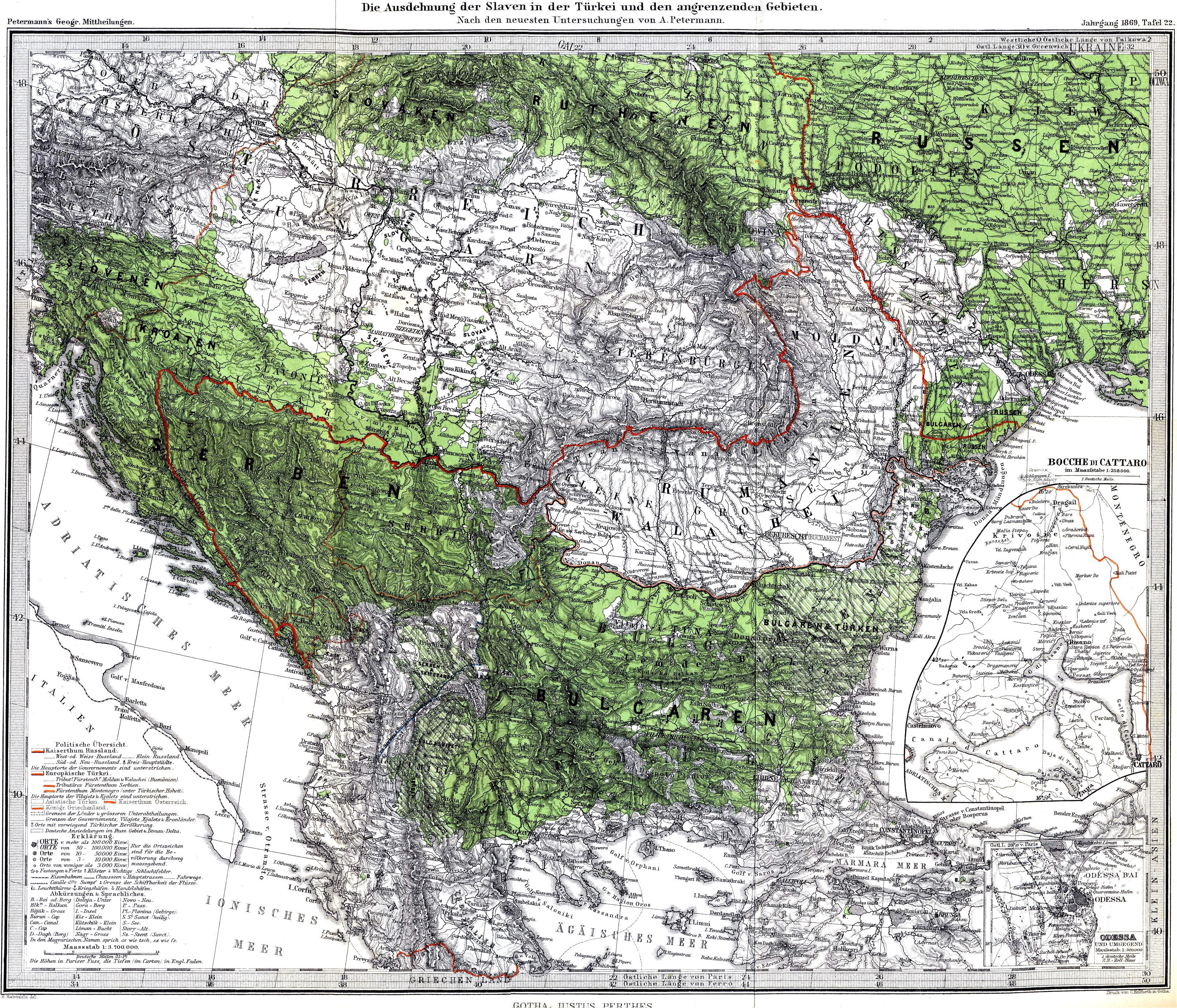
Slaven.jpg - Claude Zygiel
Roman provinces of Illyricum, Macedonia, Dacia, Moesia, Pannonia and Thracia.jpg - DIREKTOR

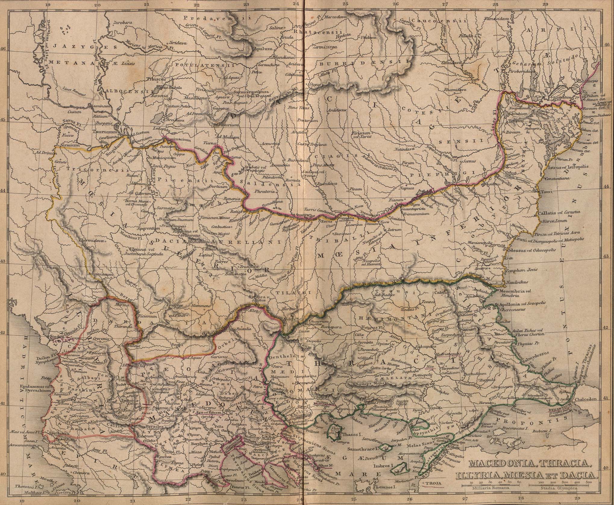
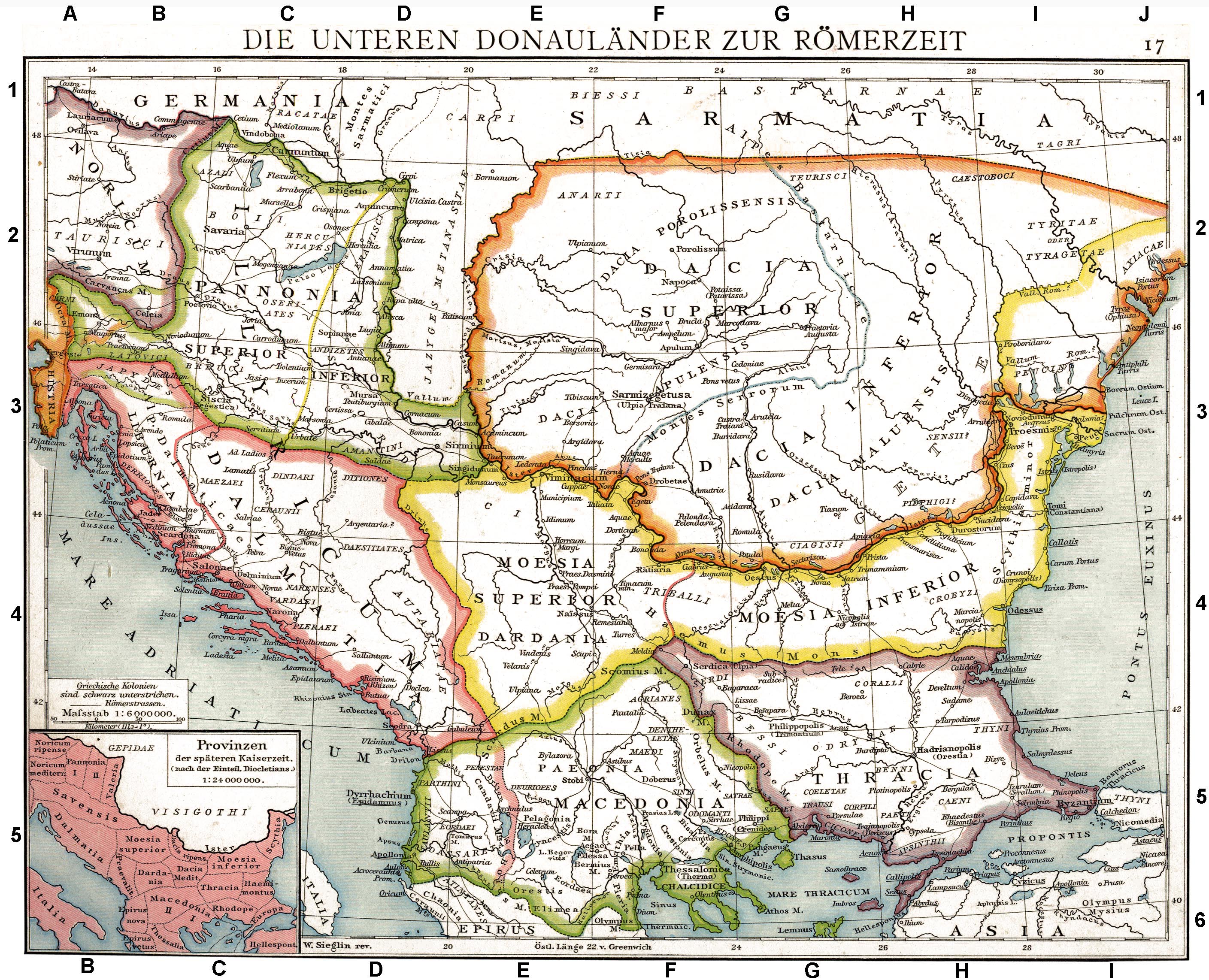
Country about the Lower Danube in Roman Times.jpg - Erik Warmelink
Muhammad al-Idrisi - Oxford transcript of V-4.jpg - Spiritia
Muhammad al-Idrisi - Paris transcript of V-4.jpg - Spiritia
Muhammad al-Idrisi - Saint Petersburg transcript of V-4.jpg - Spiritia
Muhammad al-Idrisi - Sofia transcript of V-4.jpg - Spiritia
Muhammad al-Idrisi - Oxford transcript of VI-4.jpg - Spiritia
Muhammad al-Idrisi - Paris transcript of VI-4.jpg - Spiritia
Muhammad al-Idrisi - Saint Petersburg transcript of VI-4.jpg - Spiritia
Muhammad al-Idrisi - Sofia transcript of VI-4.jpg - Spiritia
Muhammad al-Idrisi - Oxford transcript of VI-5.jpg - Spiritia
Muhammad al-Idrisi - Paris transcript of VI-5.jpg - Spiritia
Muhammad al-Idrisi - Saint Petersburg transcript of VI-5.jpg - Spiritia
Muhammad al-Idrisi - Sofia transcript of VI-5.jpg - Spiritia
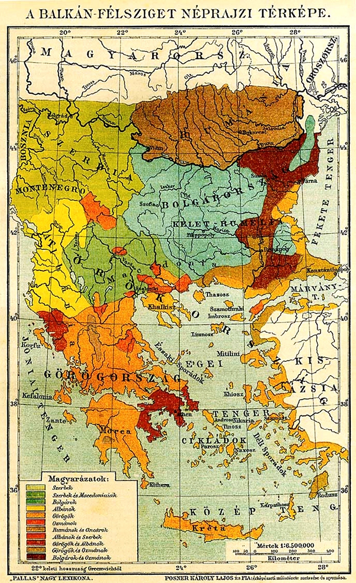
NationalitiesOfSoutheasternEuropePallasNagyLexikon.jpg - Alexandar.R.~commonswiki

Map Balkans.jpg - Rubinbot

Albanian vilayet.jpg - Mladifilozof

Epirus antiquus tabula.png - Megistias

Reilly Karte von dem Oschmanischen Reiche in Europa.jpg - Ephraim33

Map ITS NOT A MACEDONIAN - SKOPIANO MAP !!!! EthnographicalMapofCentralandSouthE.JPG - DraganKitanoski
Minia Enoz Line.jpg - Vammpi

Map of Turkey in Europe, Description de L'Universe (Alain Manesson Mallet, 1683).jpg - Geagea

Central and Eastern Europe at the time of Augustus 6 AD.jpg - Boldwin

KR 24 Estats de l'Empire du grand seigneur dit sultan et Ottomans empereur.jpg - Brest

SDUK - Turkey I. Containing the Northern Provinces.jpg - Cplakidas

BASA-121K-1-367-14-Balkan Peninsula Map.jpeg - BASA Спасимир

D531-Territoire du Bas Danube.-Liv2-ch10.png - Vieux têtard
D535- N° 406. Plus grande Turquie. - liv3-ch14.png - Vieux têtard

D266- N° 464. — Amoindrissement de la Turquie durant le XIXe siècle. - Liv3-Ch20.png - Vieux têtard
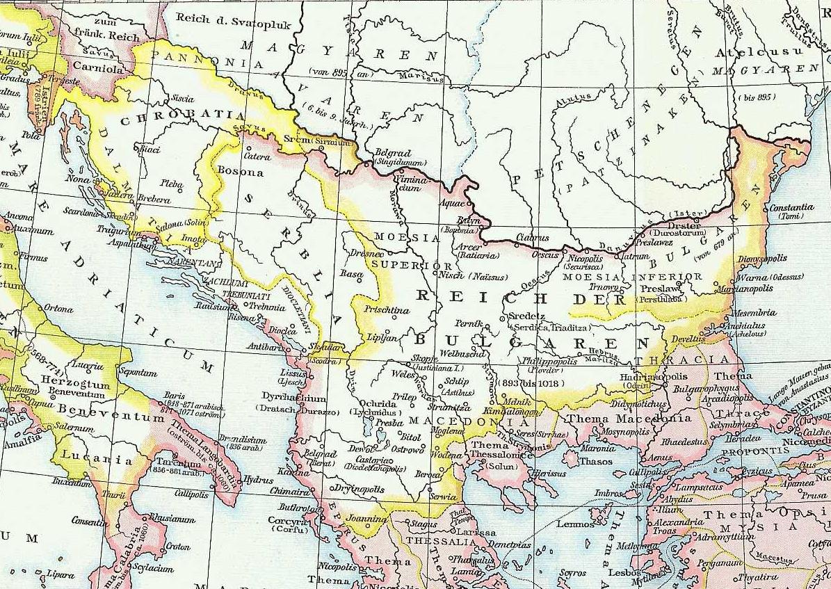
Balkans in 9th century.jpg - Diannaa
A new map of ancient Greece Thrace, Moesia, Ilyricum and the isles adjoyning. NYPL1630713.tiff - Fæ
Romania, Bulgaria, Walachia et Syrfia. NYPL1632251.tiff - Fæ
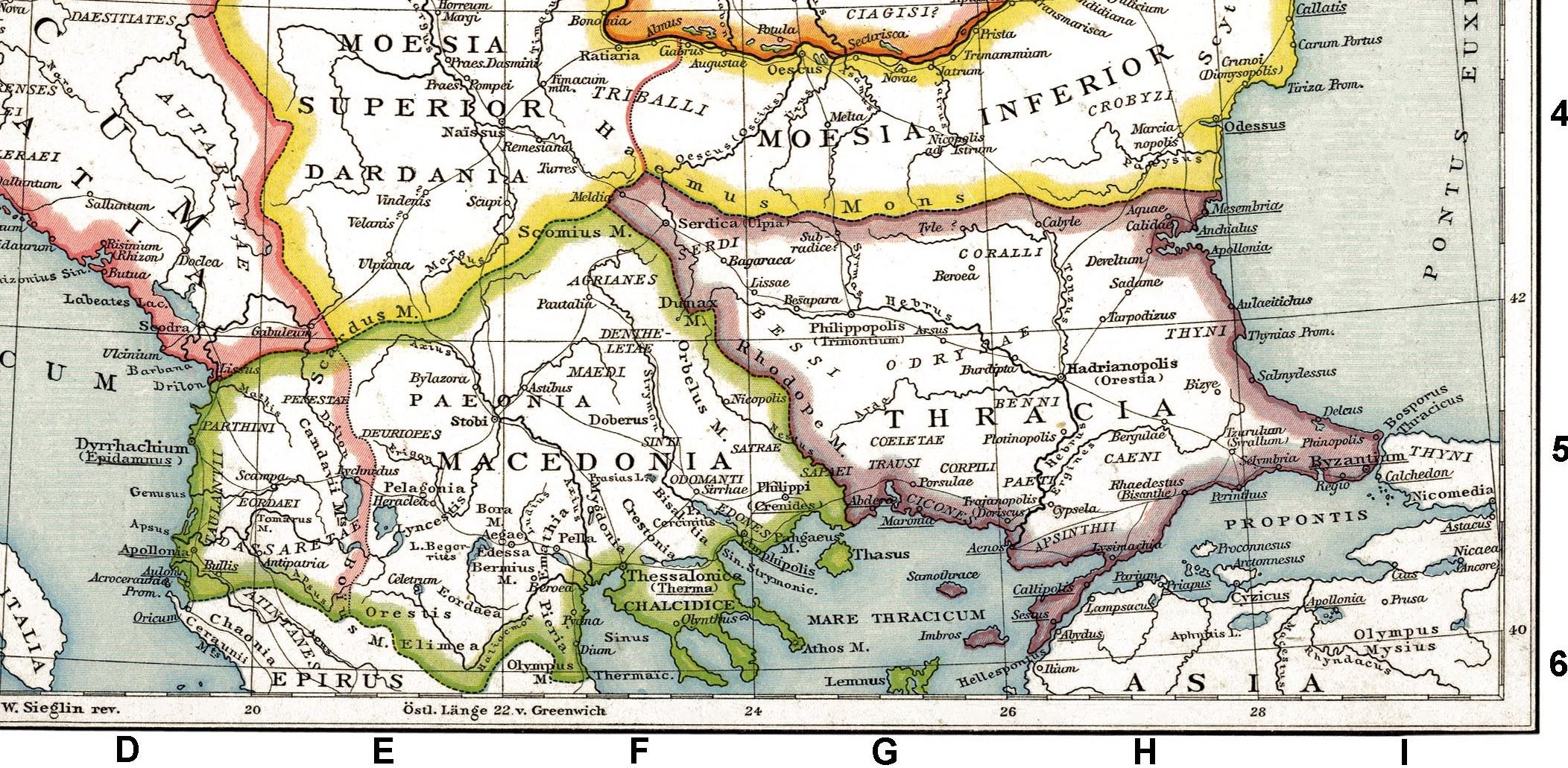
Roman provinces of Macedonia.jpg - Cristiano64

Mapaduca.png - Mnullamas

Old german map Italy and Balkans.jpg - Hoa binh

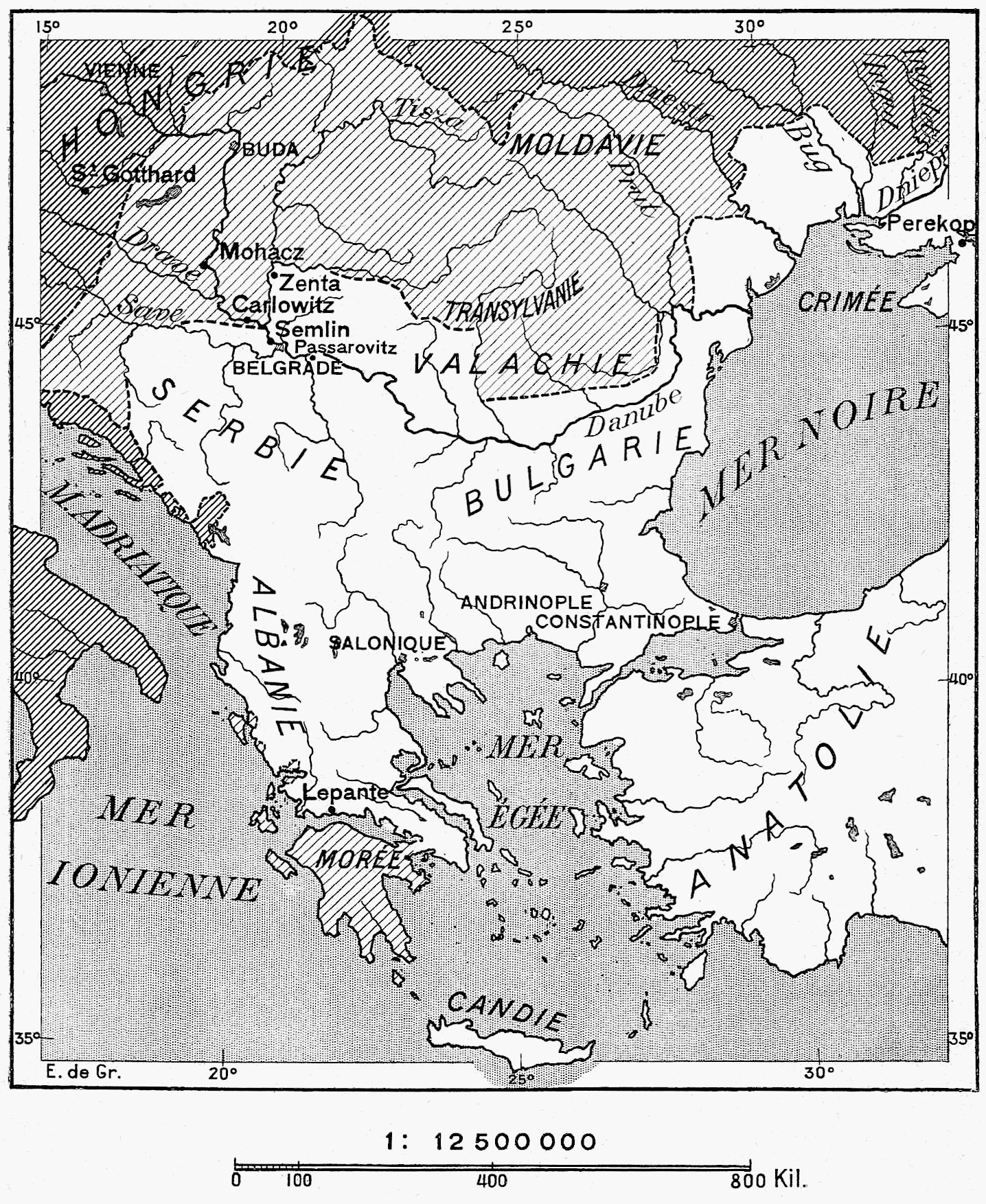
The story of the map of Europe, its making and its changing (1916) (14776044264).jpg - SteinsplitterBot

The story of the map of Europe, its making and its changing (1916) (14755308266).jpg - SteinsplitterBot

A new map of ancient Thrace, as also of the northern parts of Old Greece, viz. Macedonia, and Thessalia (NYPL b15114268-1630715).jpg - Fæ

Turquie in Europe (NYPL b14428893-1503429).jpg - Fæ

Hellas, Thessalia, Epirus terrarum antiquus 1861.jpg - MaryroseB54
Second part of Turkey in Europe .. (NYPL b13919861-5207415).tiff - Fæ

Balkan general map.jpg - Bramfab

Map of partition of Yugoslavia.jpg - Bramfab

Six engravings and one map MET sftr57372002.jpg - Pharos
Regni Hungariae, Graeciae et Moreae ac regionum quae ei quondam fuere Christiani RMG F8182.tiff - Fæ

195 of 'The Greek Islands and Turkey after the War' (11180923365).jpg - FlickreviewR 2

356 of 'The International Geography. ... Edited by H. R. Mill' (11290094896).jpg - Artix Kreiger 2
Map - Special Collections University of Amsterdam - OTM- HB-KZL 32.03.26.tif - DeJong2332
Map - Special Collections University of Amsterdam - OTM- HB-KZL 32.03.28.tif - DeJong2332
Map - Special Collections University of Amsterdam - OTM- HB-KZL 32.03.29.tif - DeJong2332
Map - Special Collections University of Amsterdam - OTM- HB-KZL 32.03.25.tif - DeJong2332
Map - Special Collections University of Amsterdam - OTM- HB-KZL 32.02.25.tif - DeJong2332
Map - Special Collections University of Amsterdam - OTM- HB-KZL 32.03.13.tif - DeJong2332
Map - Special Collections University of Amsterdam - OTM- HB-KZL 34.19.25.tif - DeJong2332
Map - Special Collections University of Amsterdam - OTM- HB-KZL 33.06.19.tif - DeJong2332
Map - Special Collections University of Amsterdam - OTM- HB-KZL 33.06.20.tif - DeJong2332
Map - Special Collections University of Amsterdam - OTM- HB-KZL 33.06.23.tif - DeJong2332
Map - Special Collections University of Amsterdam - OTM- HB-KZL 33.06.24.tif - DeJong2332
A new and elegent general atlas, containing maps of each of the United States. LOC 84675228-23.tif - Fæ

Fluviorum in Europa principis Danubii Cum Adiacentibus Regnis nec non totius Graeciae et Archipelagi Novißima Tabula.jpg - Higgenhorscht

Totius Danubii cum Adiacentibus Regnis nec non Totius Graeciae et Archipelagi Novissima Tabula.jpg - Higgenhorscht

Carte De la partie d'Albanie occupée par le Bacha de Scutari, le District des Montenegrins, et partie des Territoires des Republiques de Venise, et de Raguse.jpg - Higgenhorscht

Kriegstheater zwischen Russland Und Der Ottomanischen Pforte 01.jpg - Higgenhorscht

Die Europaeische Türkei, Griechenland und die Ionischen Inseln.jpg - Higgenhorscht

Die Europaeische Türkei.jpg - Higgenhorscht

Treaty of Berlin - Balkan Europe map.jpg - LeonDardan

Western Balkans Banner.jpg - SelfieCity

Kaart van de Balkan Nieuwe Kaat van Bosnien, Servien, Bulgarien, Romanien Graeciae enz. (titel op object), BI-B-FM-090-16.jpg - Mr.Nostalgic

Bartholomew's war map of Italy and the Balkan States (5008442).jpg - Jason.nlw

Map of the Balkan Peninsula (5008561).jpg - Jason.nlw

The states & provinces of the Balkan Peninsula (5003770).jpg - Jason.nlw

The Strand coloured detail map of the Balkan states (5003785).jpg - Jason.nlw

W & A K Johnston's war map of the Balkan States (5008033).jpg - Jason.nlw

Этнографическая карта Балкан, 1895 г.jpg - Ongoingday

Tages-Karte zur Serbischen Frage, zur Veranschaulichung der Operationsgebiete und Kriegsziele im Konflikt zwischen Oesterreich-Ungarn und Serbien - bearbeitet von Prof Paul Langhans - btv1b53063803g.jpg - Gzen92Bot

Atlas Universel de Geographie construit d'après les sources originales et les documents les plus récents, cartes, voyages, mémoires, travaux géodésiques, etc. - nouvelle édition conforme aux... - btv1b52513644d (209 of 369).jpg - Gzen92Bot

Cviic 1913 Ethnic Map.jpg - VMORO

Ethnic groups in the Balkans 1913 (138699859).jpg - Redaktor GLAM