Wikimedi'Òc
Modes d'emploi

Cet album fait partie des albums
Cet album photos contient les sous-albums suivants :


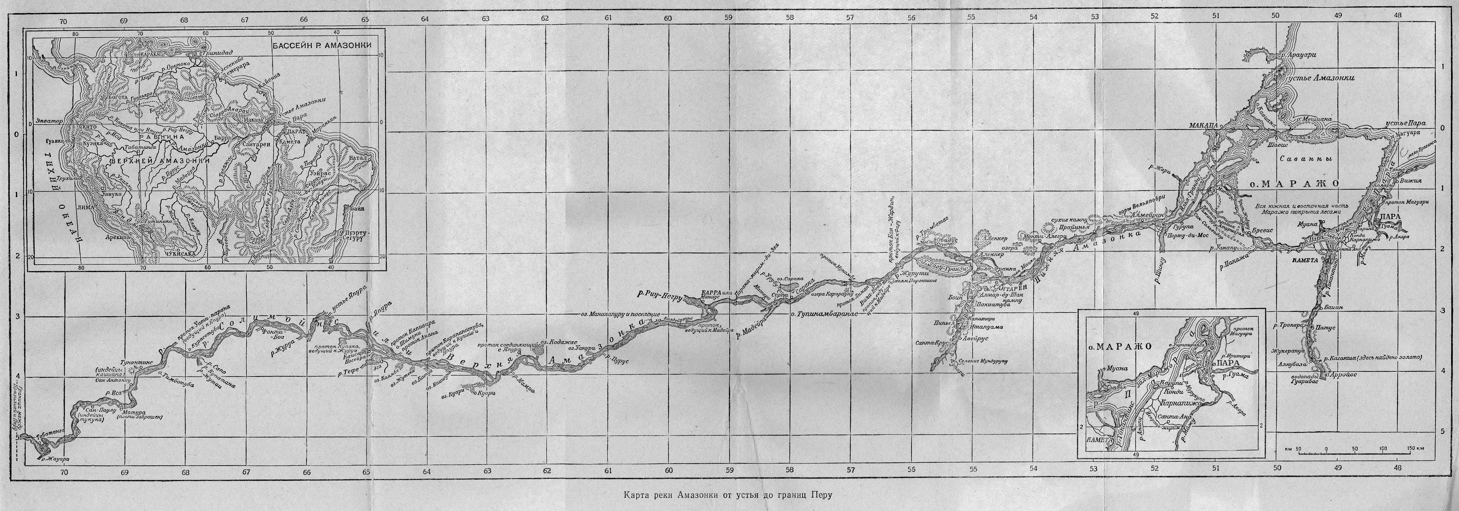
RíoAmazonas(1).JPG - Yakoo

Amazonasmuendung MK1888.png - Maksim

MapaPerú.Sanson2.JPG - Manuel González Olaechea

Map South America.jpg - 309 HWR

1562 Diego Gutierrez Amazonas.jpg - Hispalois
El-Rio-de-las-Amazonas.jpg - A.Skromnitsky

1730 Covens and Mortier Map of South America - Geographicus - SouthAmerica-covensmortier-1730.jpg - BotMultichillT

1635 Blaeu Map Guiana, Venezuela, and El Dorado - Geographicus - Guiana-blaeu-1635.jpg - BotMultichillT

'Eight Hundred Leagues on the Amazon' by Léon Benett 23.jpg - Electron

'Eight Hundred Leagues on the Amazon' by Léon Benett 82.jpg - Electron

1562 Americae-Gutierrez map 06hrs-inn Benezuela-Amazones-Regio-de-Brasil.jpg - Jaybear

Carta de América del Sur Amazonica, Andina y tórrida - AHG.jpg - Jojagal

D113- carte des routes amazoniennes des Mojos. - L1-Ch2.png - Vieux têtard

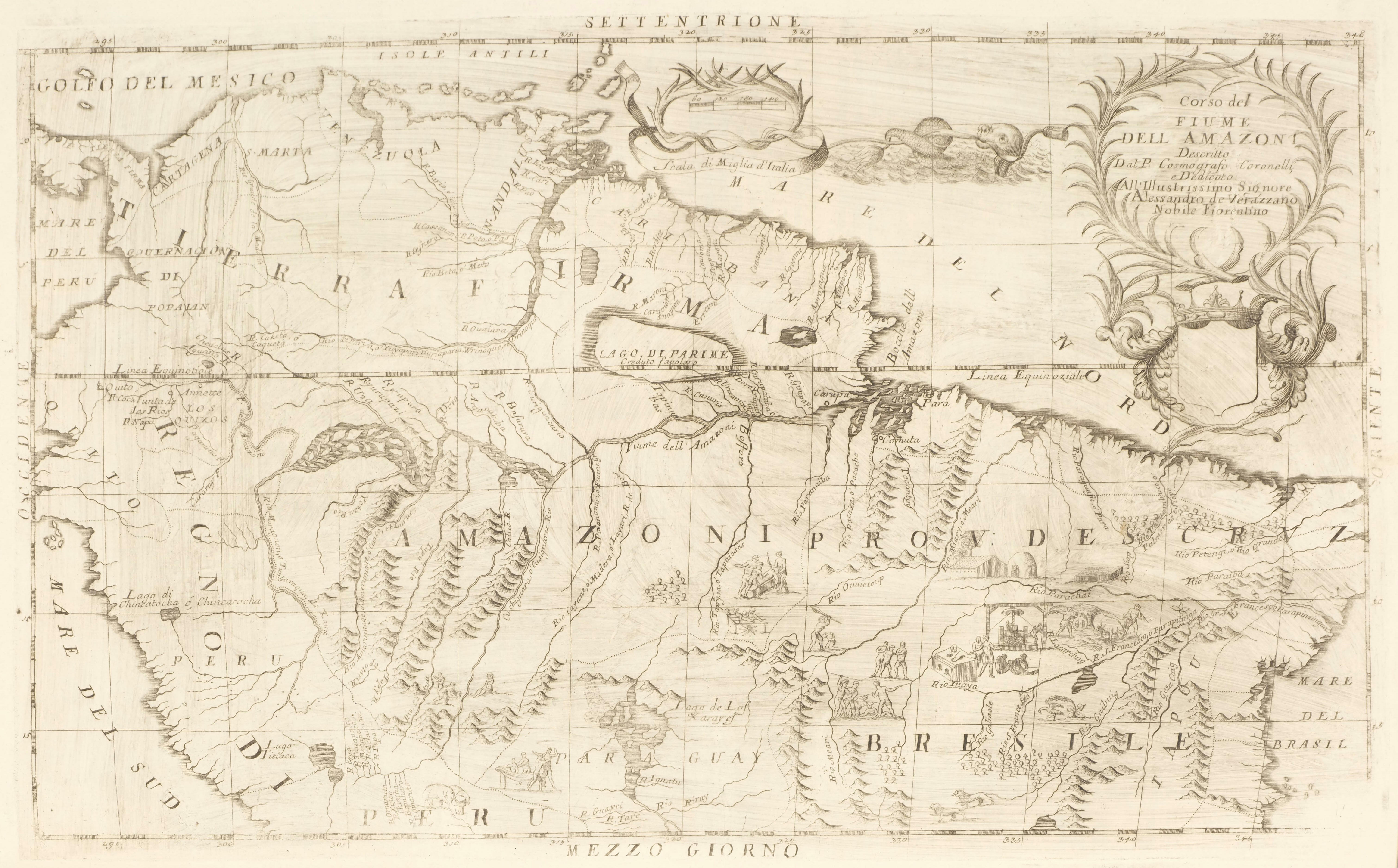
Corso del fiume dell Amazon (8642164049).jpg - File Upload Bot (Magnus Manske)

Carte de la Terre Ferme, du Perou, du Bresil et du Pays des Amazones (4586557403).jpg - File Upload Bot (Magnus Manske)

A map of Terra Firma Peru, Amazone-land, Brasil & the north part of La Plata (4578690817).jpg - File Upload Bot (Magnus Manske)

The Course of the River of the Amazons, Based on the Account of Christopher d’Acugna WDL139.png - Fæ

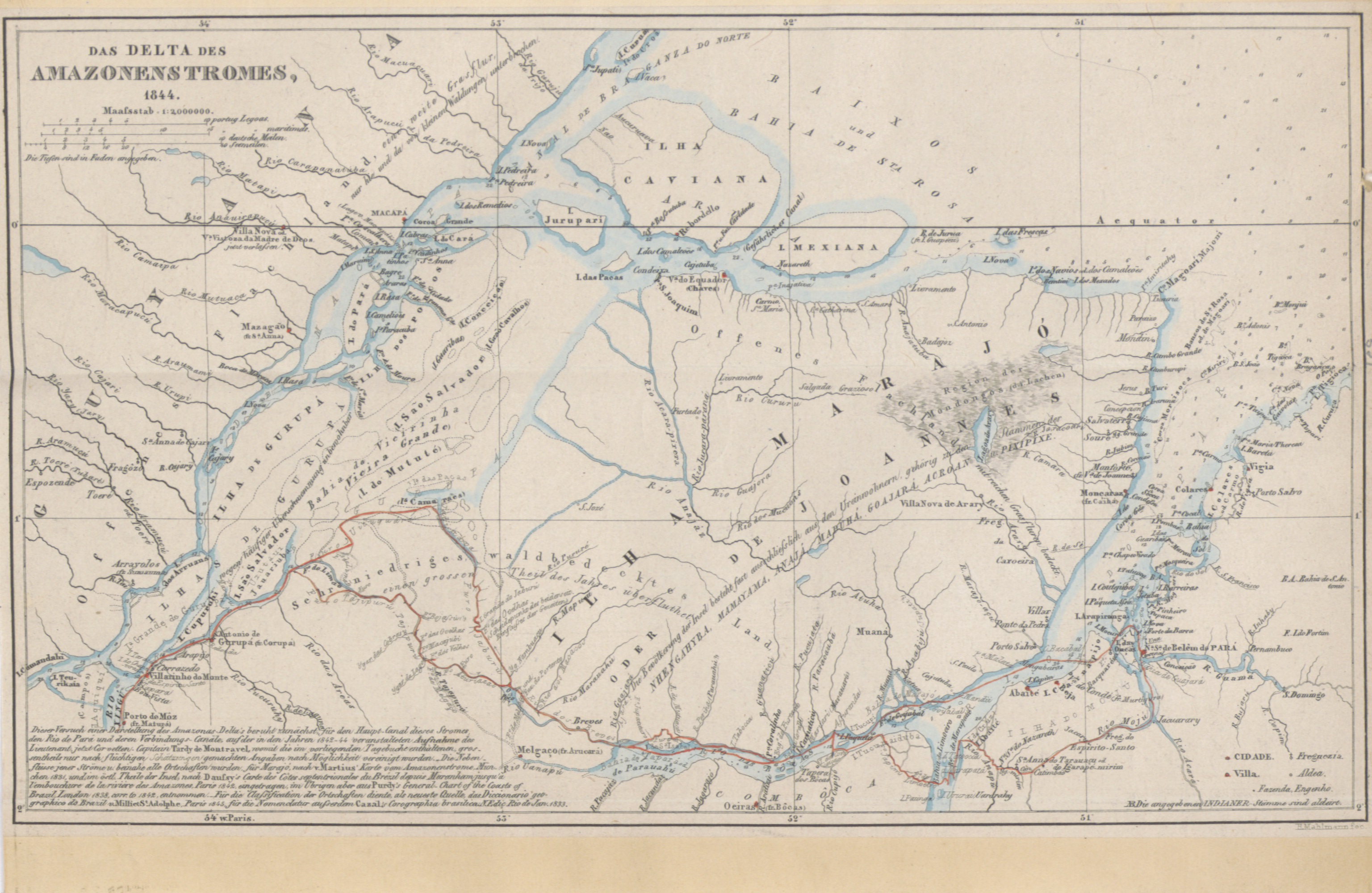
General Map of the Diocese of Pará- Shows the Division of Parishes Where the Venerable Father Miguel de Bulhões III, Bishop from Pará, Founded and Built the Diocese WDL825.jpg - Fæ

Topographic Map of the Principal Entry to the Amazon River WDL866.png - Fæ

The New Map of the North of the Coast of Brazil Showing Distances of the Pará and Amazon Rivers WDL996.png - Fæ

AMH-8043-KB Map of the course of the Amazon.jpg - HuskyBot

The Andes and the Amazon - or, Across the continent of South America (1870) (18196298031).jpg - Fæ

Narrative of a journey from Lima to Para, across the Andes and down the Amazon- undertaken with a view of ascertaining the practicability of a navigable communication with the Atlantic, by the rivers (14775312474).jpg - Fæ

Narrative of a journey from Lima to Para, across the Andes and down the Amazon- undertaken with a view of ascertaining the practicability of a navigable communication with the Atlantic, by the rivers (14591017348).jpg - Fæ

Amazonaskarte Bry 1599.jpg - Jordi

1180 of 'Géographie générale; physique, politique et économique. ... Avec ... cartes ... gravures, etc' (11112571574).jpg - FlickreviewR 2

205 of 'Les Français en Guyane ... Illustrations, etc. (With a preface by H. A. Coudreau.)' (11188249714).jpg - FlickreviewR 2

319 of 'Voyage à travers l'Amérique du Sud, de l'Océan Pacifique à l'Océan Atlantique ... Illustré ... par E. Riou, etc' (11088652073).jpg - SteinsplitterBot

367 of 'Voyage à travers l'Amérique du Sud, de l'Océan Pacifique à l'Océan Atlantique ... Illustré ... par E. Riou, etc' (11088073194).jpg - Artix Kreiger 2

437 of 'Voyage à travers l'Amérique du Sud, de l'Océan Pacifique à l'Océan Atlantique ... Illustré ... par E. Riou, etc' (11089372015).jpg - Artix Kreiger 2

465 of 'Voyage à travers l'Amérique du Sud, de l'Océan Pacifique à l'Océan Atlantique ... Illustré ... par E. Riou, etc' (11088964506).jpg - SteinsplitterBot

481 of 'Voyage à travers l'Amérique du Sud, de l'Océan Pacifique à l'Océan Atlantique ... Illustré ... par E. Riou, etc' (11090247934).jpg - Artix Kreiger 2
517 of '(A Journey across South America, from the Pacific Ocean to the Atlantic Ocean. (Translated from the French by E. Rich.) Illustrated with engravings ... drawn by E. Riou, and.. maps, printed in colours, etc.)' (11107948685).jpg - SteinsplitterBot

427 of 'Voyage à travers l'Amérique du Sud, de l'Océan Pacifique à l'Océan Atlantique ... Illustré ... par E. Riou, etc' (11089017425).jpg - SteinsplitterBot
515 of '(A Journey across South America, from the Pacific Ocean to the Atlantic Ocean. (Translated from the French by E. Rich.) Illustrated with engravings ... drawn by E. Riou, and.. maps, printed in colours, etc.)' (11111130895).jpg - SteinsplitterBot
519 of '(A Journey across South America, from the Pacific Ocean to the Atlantic Ocean. (Translated from the French by E. Rich.) Illustrated with engravings ... drawn by E. Riou, and.. maps, printed in colours, etc.)' (11108818283).jpg - Artix Kreiger 2

1194 of 'La Terra, trattato popolare di geografia universale per G. Marinelli ed altri scienziati italiani, etc. (With illustrations and maps.)' (11246810366).jpg - Artix Kreiger 2

183 of 'Voyage au Brésil, traduit de l'anglais ... par F. Vogeli. Ouvrage illustré, etc' (11088109693).jpg - Artix Kreiger 2

617 of 'Aus meinem Tagebuche 1842-1843, von Adalbert Prinz v. Preussen. Als Manuscript gedruckt' (11027062545).jpg - Artix Kreiger 2
569 of 'Aus meinem Tagebuche 1842-1843, von Adalbert Prinz v. Preussen. Als Manuscript gedruckt' (11026938373).jpg - FlickreviewR 2

433 of 'Voyage à travers l'Amérique du Sud, de l'Océan Pacifique à l'Océan Atlantique ... Illustré ... par E. Riou, etc' (11089302244).jpg - Artix Kreiger 2

449 of 'Voyage à travers l'Amérique du Sud, de l'Océan Pacifique à l'Océan Atlantique ... Illustré ... par E. Riou, etc' (11089993206).jpg - SteinsplitterBot

26 of 'Arnold's Geographical Handbooks' (11251952145).jpg - FlickreviewR 2

55 of 'Atlas' (11192233673).jpg - Artix Kreiger 2

33 of 'Les Français en Amazonie ... Illustrations par P. Hercouët et F. Massé' (11192652893).jpg - FlickreviewR 2

480 of 'Mission from Cape Coast Castle to Ashantee; with a statistical account of that kingdom, and geographical notices of other parts of the interior of Africa. (With plates and maps.)' (11002059934).jpg - Artix Kreiger 2

398 of 'A Class-Book of Modern Geography ... New edition, revised and largely rewritten (by Albert Hill), etc' (11156004223).jpg - Artix Kreiger 2

455 of 'Le Pays des Amazones. L'El-Dorado. Les terres à caoutchouc ... Orné de nombreuses illustrations et d'une carte explicative. Nouvelle édition entièrement refondue et mise à jour' (11252713713).jpg - Artix Kreiger 2

CARTE DE LA TERRE FERME DU PEROU, DU BRESIL ET DU PAYS DE S AMAZONES - Guillaume de L'Isle, 1703-1708 - BL Maps K.Top.124.4.b (BLL01018640914).jpg - JhealdBot

Brasilien.jpg - Higgenhorscht

Karte des Weges der zweiten Schingú-Expedition vom 28. Juli bis 31. December 1887.jpg - Higgenhorscht

Karte des Weges von Cuyabá nach Coxim über die Serra de São Jeronymo.jpg - Higgenhorscht

Cours Du Fleuve Maragnon autrement dit Des Amazones.jpg - Higgenhorscht

Histoire des deux Indes-Atlas-d53-C30-Amazone ou Maragnon.png - Vieux têtard

English guiana guayana inglesa y Venezuela en 1831.jpg - Warairarepano&Guaicaipuro

Naturalist on the River Amazons Map.png - M-le-mot-dit

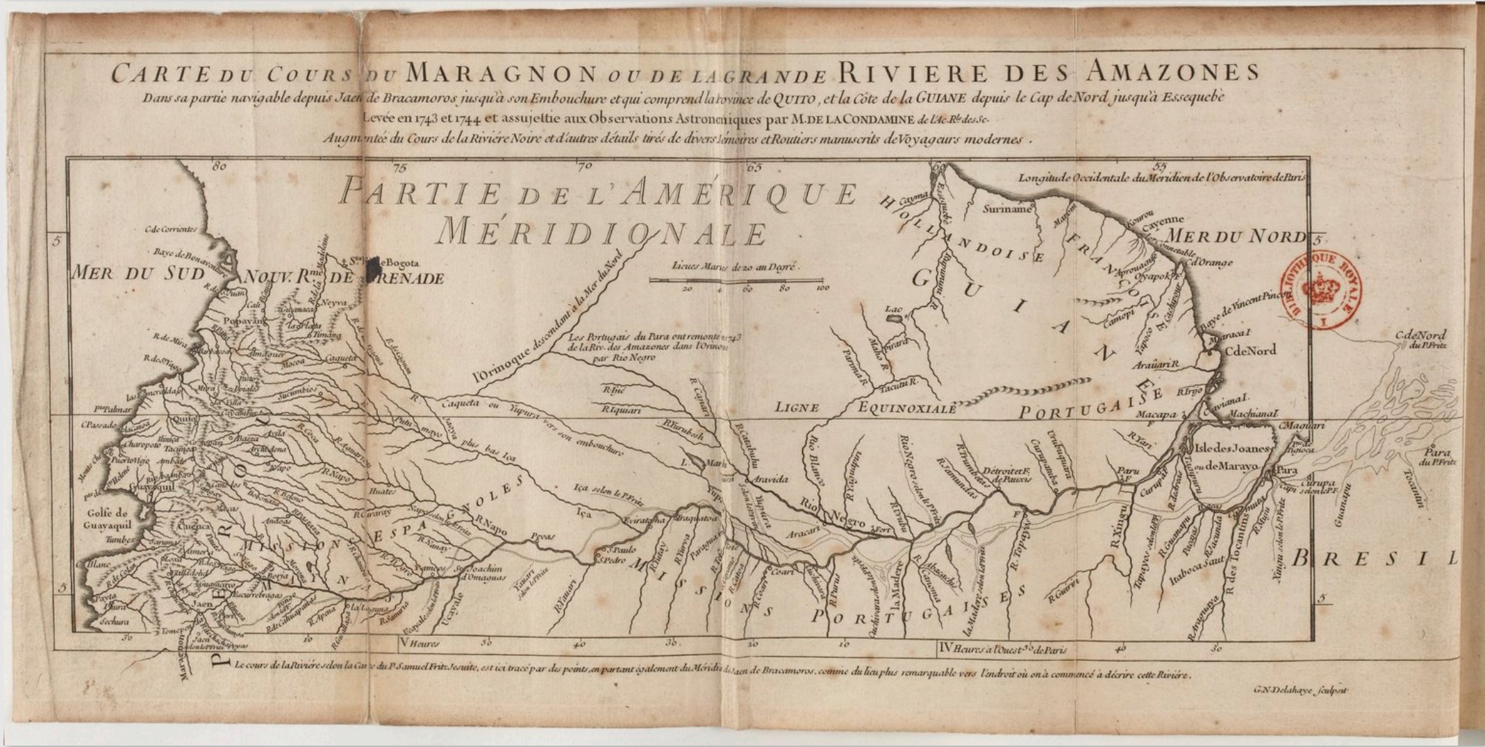
Carte du cours du Maragnon ou de la grande riviere des Amazones dans sa partie navigable depuis Jaen de Bracamoros jusqu 'à son embouchure et qui comprend la province de Quito et la Côte de la Guian, COLLBN Port 191 N 33.tiff - Mr.Nostalgic

Carte du cours du Maragnon ou de la grande route des Amazones dans sa partie navigable depuis Jaen de Bracomoros jusqu'à son embouchure et qui comprend la Province de Quito, et la côte de la Guiane depuis le Cap de... - btv1b8596751c.jpg - Gzen92Bot

The Complete Brazil and Cape of Good Hope pilot - being a collection of new and accurate charts, both general and particular, exhibiting the whole navigation from London to the Cape of Good Hope, Isle of... - btv1b106785686 (09 of 14).jpg - Gzen92Bot

Embouchure de la Rivière des Amazones - btv1b85967588.jpg - Gzen92Bot

Carte du cours du Maragnon ou de la grande rivière des Amazones dans sa partie navigable depuis Jaen de Bracameros jusqu'à son embouchure et qui comprend la Province de Quito et de la cote de la Guyane depuis le... - btv1b84922122.jpg - Gzen92Bot

Cours du Maragnon ou du fleuve des Amazones. ... Le cours du fleuve et les noms des lieux suivant la carte du Père Samuel Frits sont marquée en jaune. 100 lieues de vingt lieues au degré - btv1b530647094.jpg - Gzen92Bot

Carte du cours de la rivière des Amazones ou de Maragnon depuis l'entrée du Para en remontant jusqu'au confluent de la Rivière Noireoù l'on a marqué entre autres circonstances,les établissements des Portugais... - btv1b8596756f.jpg - Gzen92Bot

Cours du fleuve Maragnon autrement dit des Amazones - par le P. Samuel Fritz missionnaire de la Compagnie de Jésus - btv1b8596750z.jpg - Gzen92Bot

Carte du détroit appelé Pongo de Mansériché dans le Maragnon ou la rivière des Amazones entre Sant-Iago et Borja... Du point du départ le radeau abandonné au courant est arrivé devant Borja en 57 minutes... - btv1b8491101m.jpg - Gzen92Bot

Cours du fleuve Maragnon, autrement dit des Amazones - par le P. Samuel Fritz, Missionnaire de la Compagnie de Jésus - btv1b8446618s.jpg - Gzen92Bot

Carte du détroit appelé Pongo de Mansoriche dans le Maragnon ou la Rivière des Amazones entre Sant-Yago et Borja où le lit du Fleuve se rétrécit jusqu'à 25 à 30 toises - btv1b53009305p.jpg - Gzen92Bot

Ile de Marajo - btv1b53121738x.jpg - Gzen92Bot

A map of the course of the Maragnon, or Great River of Amazons, as far as it is navigable - from Jaen de Bracamoros to its mouth... drawn in 1743 and 1744, by Monsr. de la Condamine... Whereto is added the course... - btv1b8441127g.jpg - Gzen92Bot

Le cours du Maragnon. 1 - 8 700 000 env - btv1b8493522s.jpg - Gzen92Bot

Cours du fleuve Maragnon, autrement dit des Amazones - par le P. Samuel Fritz, Missionnaire de la Compagnie de Jésus - btv1b8446617c.jpg - Gzen92Bot

Carte du cours du Maragnon ou de la grande rivière des Amazones dans sa partie navigable depuis Jaen de Bracameros jusqu'à son embouchure et qui comprend la Province de Quito et de la cote de la Guyane depuis le... - btv1b84910834.jpg - Gzen92Bot

Cours du fleuve Maragnon ou rivière des Amazones - par le P(ère) Fritz - btv1b53009302b.jpg - Gzen92Bot

Carte du Détroit appelé Pongo de Mansériché dans le Maragnon ou la Rivière des Amazones entre Sant-Yago et Borja où le lit du fleuve se rétrécit de 250 toises à 25 toises - btv1b8596519g.jpg - Gzen92Bot
1692 map of the Amazon in Atlante Veneto Volume 1.jpg - SteinsplitterBot
Mapa la Condamine.jpg - Mglandasteam

Alfred R. Wallace Map of Amazon river 1853.jpg - Goesseln

Le Tour du monde - 14 (page 138 crop).jpg - Zazaattila55

Admiralty Chart No 2229 River Amazon Gurupa to Iquitos, Published 1910 (Composite).jpg - Kognos

Admiralty Chart No 2229 River Amazon Gurupa to Iquitos, Published 1910.jpg - Kognos