Wikimedi'Òc
Modes d'emploi

Cet album fait partie des albums
Cet album photos contient les sous-albums suivants :


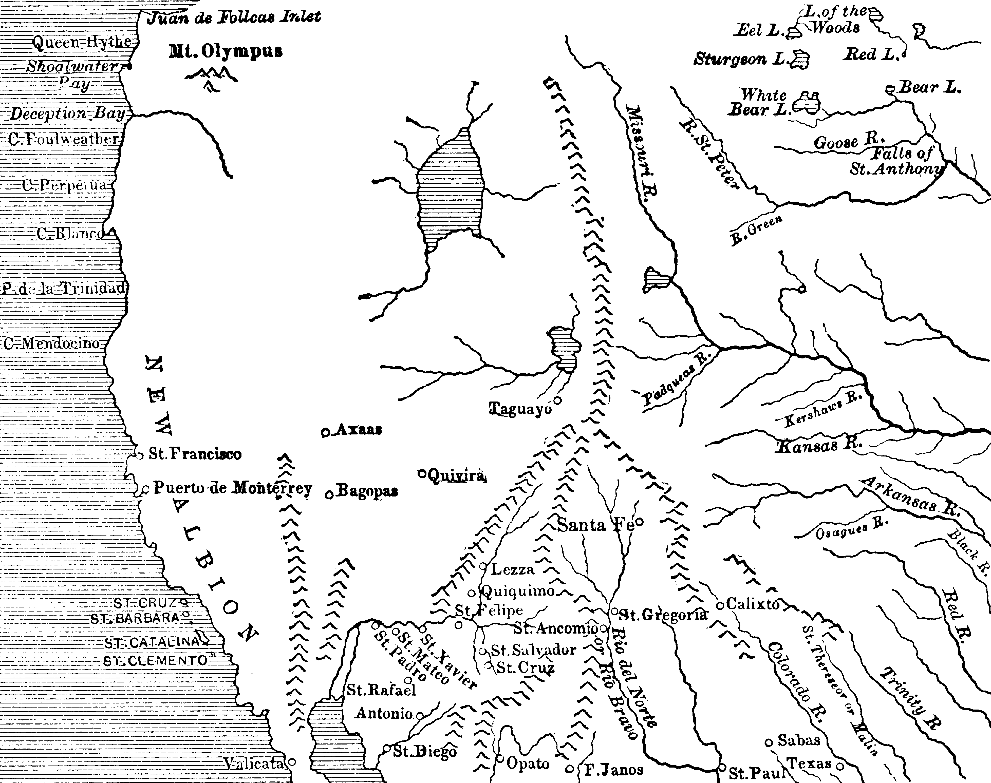
Probable Route of Cardenas BHoU-p5.png - Moverton

Green River Country BHoU-p24.png - Moverton
Utah and Nevada 1795 BHoU-p27a.png - Moverton
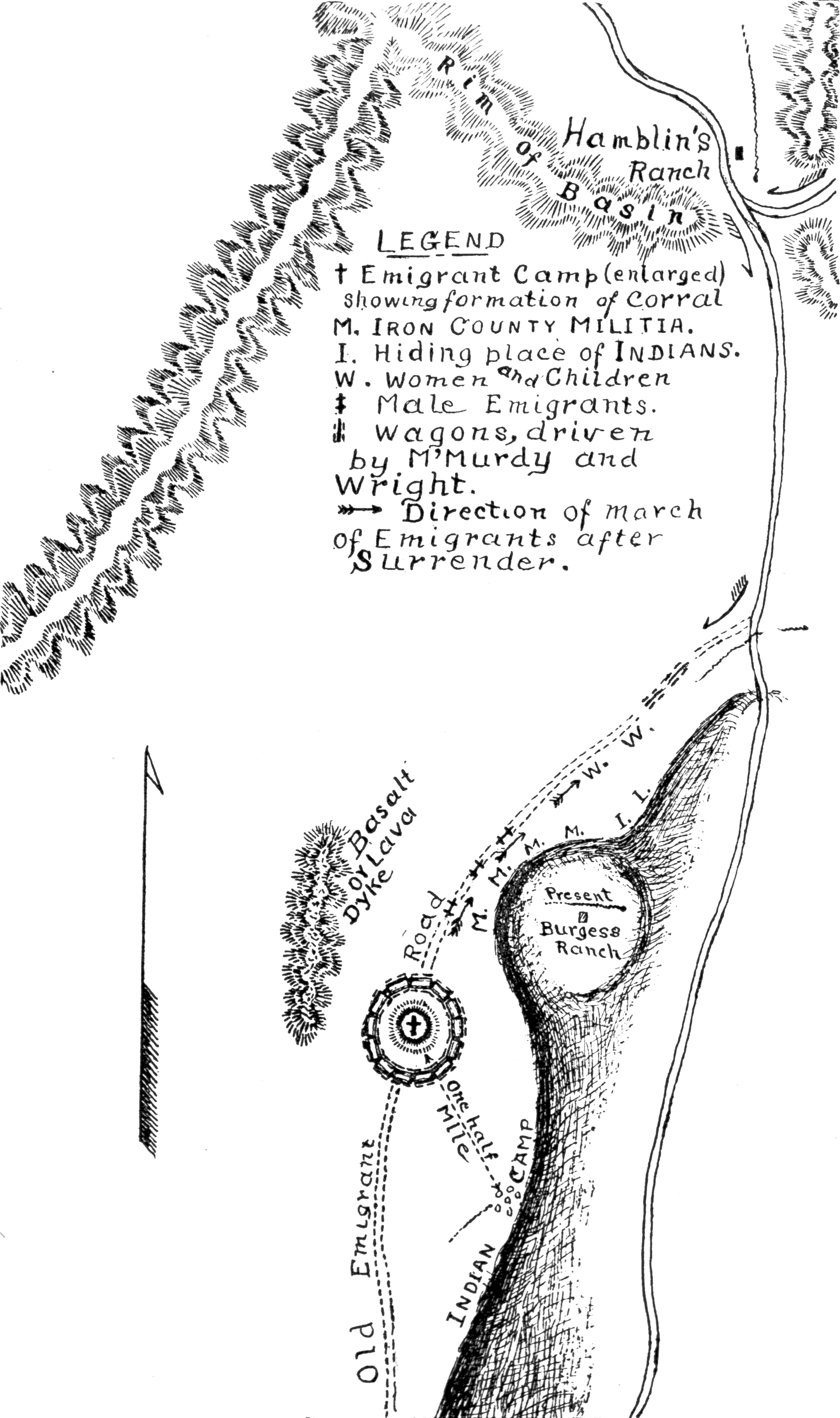
Mountain-meadows-ut-us-map.png - Xhienne

1855 Jefferson Davis Map of Utah, Salt Lake City, and the Green River Valley - Geographicus - GreenRiverSaltLake-davis-1855.jpg - BotMultichill
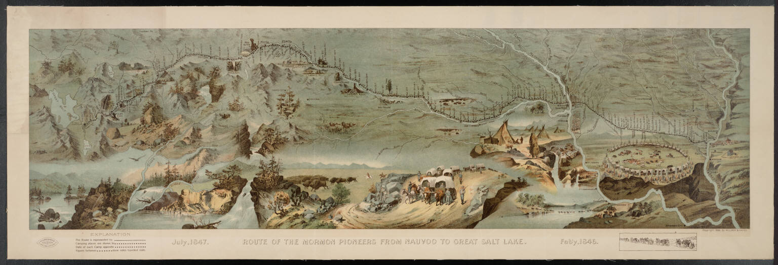
Route of the Mormon pioneers from Nauvoo to Great Salt Lake.jpg - MarmadukePercy

The Overland Route 1908 Map.jpg - File Upload Bot (Magnus Manske)
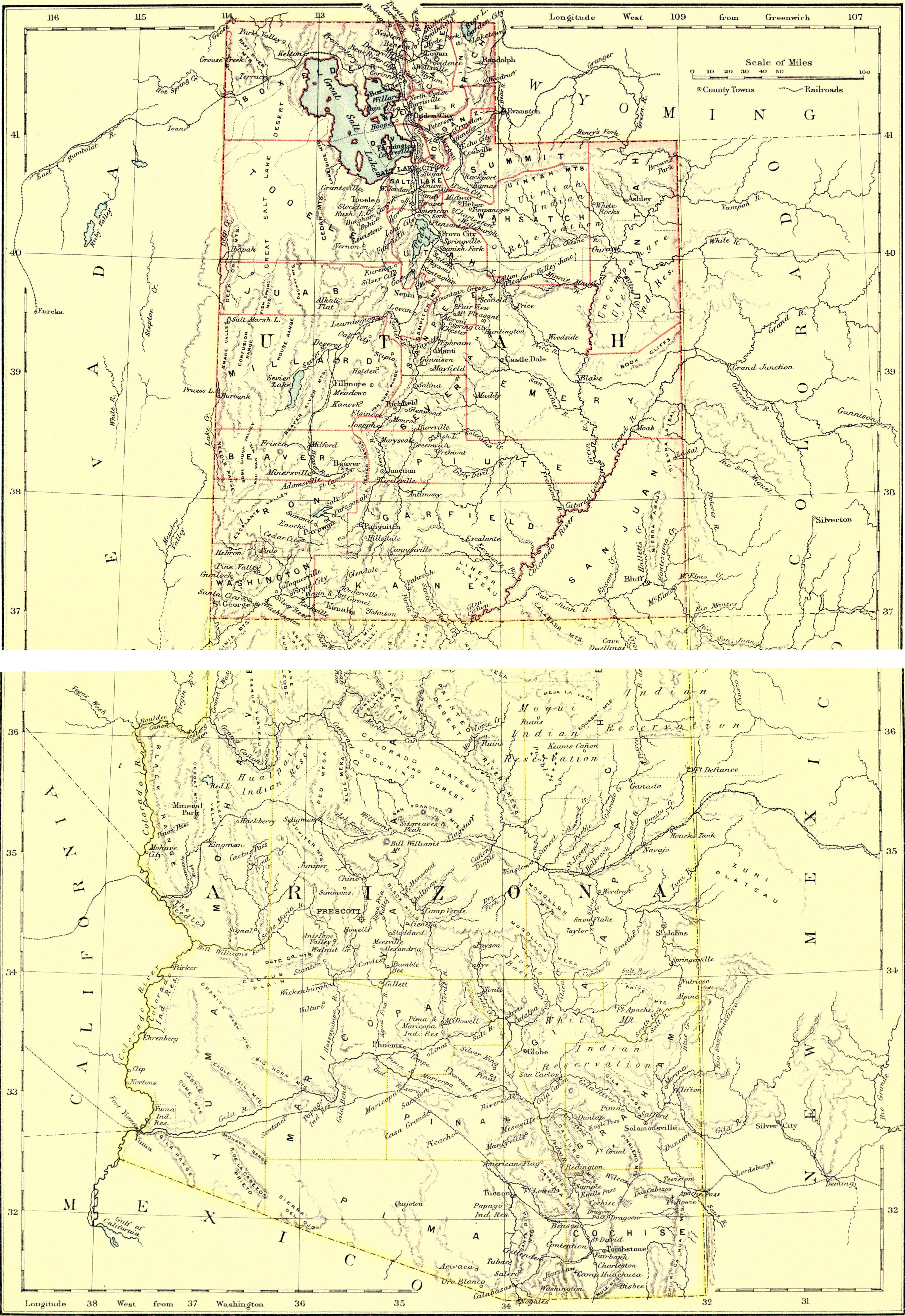
EB9 Utah - Utah and Arizona.jpg - Bob Burkhardt

Map of explorations and surveys in New Mexico and Utah made under the direction of the Secretary of War by Capt. J. N. Macomb topl. engrs. assisted by C. H. Dimmock. c. engr. 1860 (7537874502).jpg - File Upload Bot (Magnus Manske)

G. M. Wheeler, Topographical atlas 1869-1878 Wellcome L0027632.jpg - Fæ

G. M. Wheeler, Geological atlas Wellcome L0027638.jpg - Fæ

Annual report of the Bureau of American Ethnology to the Secretary of the Smithsonian Institution (1895) (18741625593).jpg - SteinsplitterBot

Annual report of the Bureau of American Ethnology to the Secretary of the Smithsonian Institution (1895) (19356151542).jpg - SteinsplitterBot

Annual report of the Bureau of American Ethnology to the Secretary of the Smithsonian Institution (1895) (19174612020).jpg - SteinsplitterBot

Annual Reports of the Department of the Interior 1905 (1905) (14804570283).jpg - Fæ

Bulletin (1941) (20416141952).jpg - Fæ

The alfalfa weevil - (Phytonomus murinus) (1911) (17763401689).jpg - Fæ

Cenozoic mammal horizons of western North America (1909) (20561293046).jpg - Fæ

Polk's real estate register and directory of the United States and Canada (1911) (14765123224).jpg - Fæ

Bulletin of the Museum of Comparative Zoology at Harvard College (1900-1903) (19868964173).jpg - Fæ

New dollar atlas of the United States and Dominion of Canada (1884) (14766944682).jpg - Fæ

610 of '(Patton's Concise History of the American People, from the disoveries of the Continent to 1876 ... Illustrated, etc.)' (11191767104).jpg - Artix Kreiger 2
From Great Salt Lake to the Humboldt Mountains. LOC 98688430.tif - Fæ

From Great Salt Lake to the Humboldt Mountains. LOC 98688430.jpg - Fæ
Map of location 11th hundred miles U.P.R.R. - (Utah) LOC 2012586559.tif - Fæ

Map of location 11th hundred miles U.P.R.R. - (Utah) LOC 2012586559.jpg - Fæ
From the valley of Green River to the Great Salt Lake. LOC 98688429.tif - Fæ

From the valley of Green River to the Great Salt Lake. LOC 98688429.jpg - Fæ
(Mormon Temple Salt Lake City). LOC 99446203.tif - Fæ

(Mormon Temple Salt Lake City). LOC 99446203.jpg - Fæ
Map of the Great Salt Lake and adjacent country in the territory of Utah - surveyed in 1849 and 1850 under the orders of Col. J.J. Abert LOC 2018588045.tif - Fæ

Map of the Great Salt Lake and adjacent country in the territory of Utah - surveyed in 1849 and 1850 under the orders of Col. J.J. Abert LOC 2018588045.jpg - Fæ
Map of wagon routes in Utah Territory LOC 2012586633.tif - Fæ

Map of wagon routes in Utah Territory LOC 2012586633.jpg - Fæ
Territory and military department of Utah LOC 2015591071.tif - Fæ

Baker 1936 USGS Bulletin 865 plate-1.jpg - Kognos

Gregory 1938 USGS Professional Paper 188 Plate 1.jpg - Kognos

Gregory 1938 USGS Professional Paper 188 Plate 17.jpg - Kognos
Map of Utah territory representing the extent of the irrigable, timber and pasture lands LOC 2006636646.tif - Fæ

Map of Utah territory representing the extent of the irrigable, timber and pasture lands LOC 2006636646.jpg - Fæ

Relief map of Utah LOC 2005625336.jpg - Fæ
Salt Lake City, Utah 1891. LOC 75696616.tif - Fæ

Salt Lake City, Utah 1891. LOC 75696616.jpg - Fæ
(Plat of the Great City of the Valley of the Great Salt Lake) LOC 2017587026.tif - Fæ

(Plat of the Great City of the Valley of the Great Salt Lake) LOC 2017587026.jpg - Fæ
The Great Western Trail corridor LOC 97682184.tif - Fæ

The Great Western Trail corridor LOC 97682184.jpg - Fæ
Map of a reconnoissance between Fort Leavenworth on the Missouri River and the Great Salt Lake in the Territory of Utah, made in 1849 and 1850 under the orders of J.J. Albert (IA mapofreconnoissa00stan).pdf - Fæ
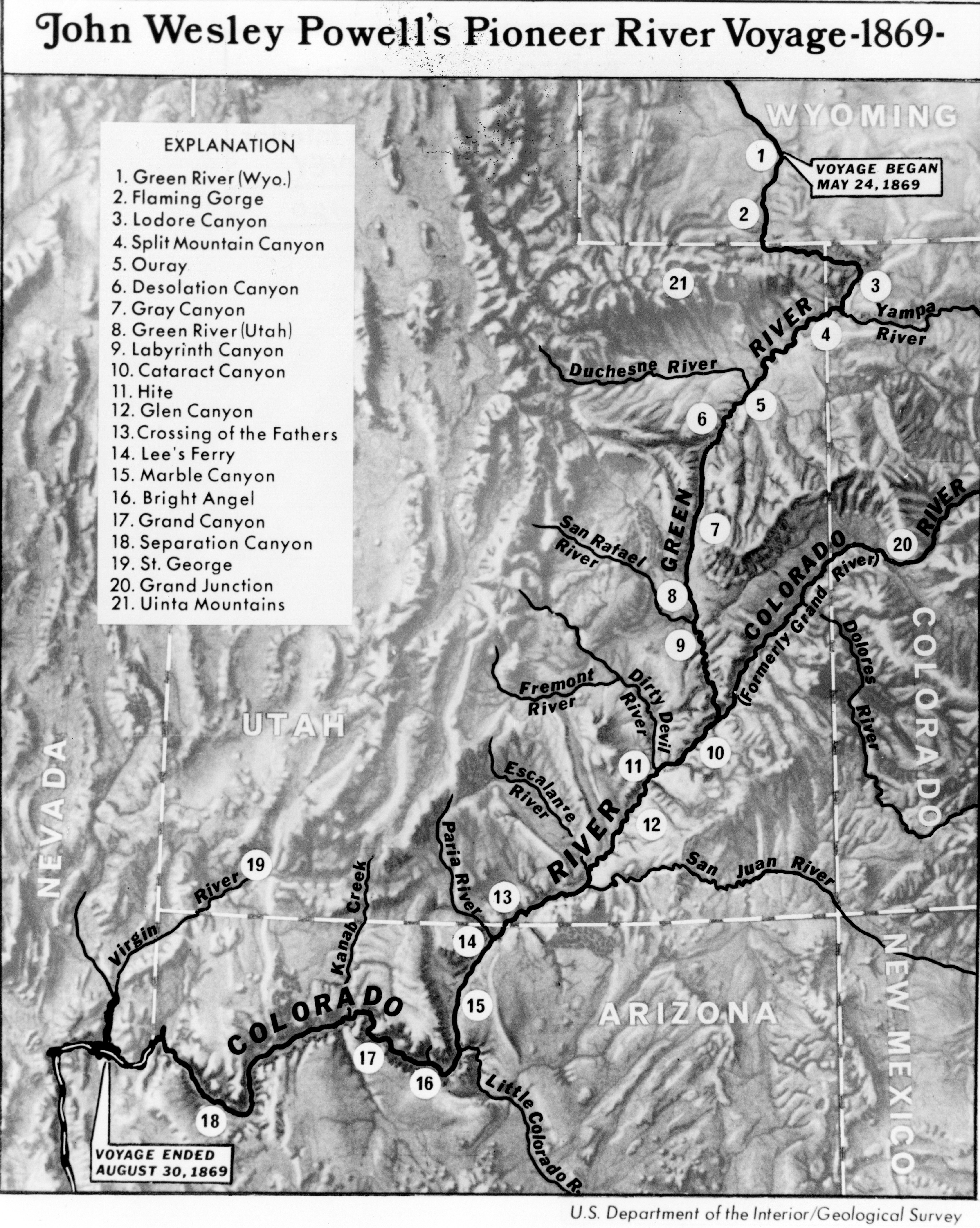
First Powell Expedition 1869 USGS Pioh120.jpg - Broichmore

Territory of Utah - DPLA - ad0e5e8cb5180a865527644f08f608f7.jpg - DPLA bot

Map of Nevada and -Utah - NARA - 86455527.jpg - US National Archives bot

Map of Oregon, Idaho, Nevada, and Utah - NARA - 93193292.jpg - US National Archives bot

Provo 1920.jpg - Marsonmars