Wikimedi'Òc
Modes d'emploi

Cet album fait partie des albums
Cet album photos contient les sous-albums suivants :


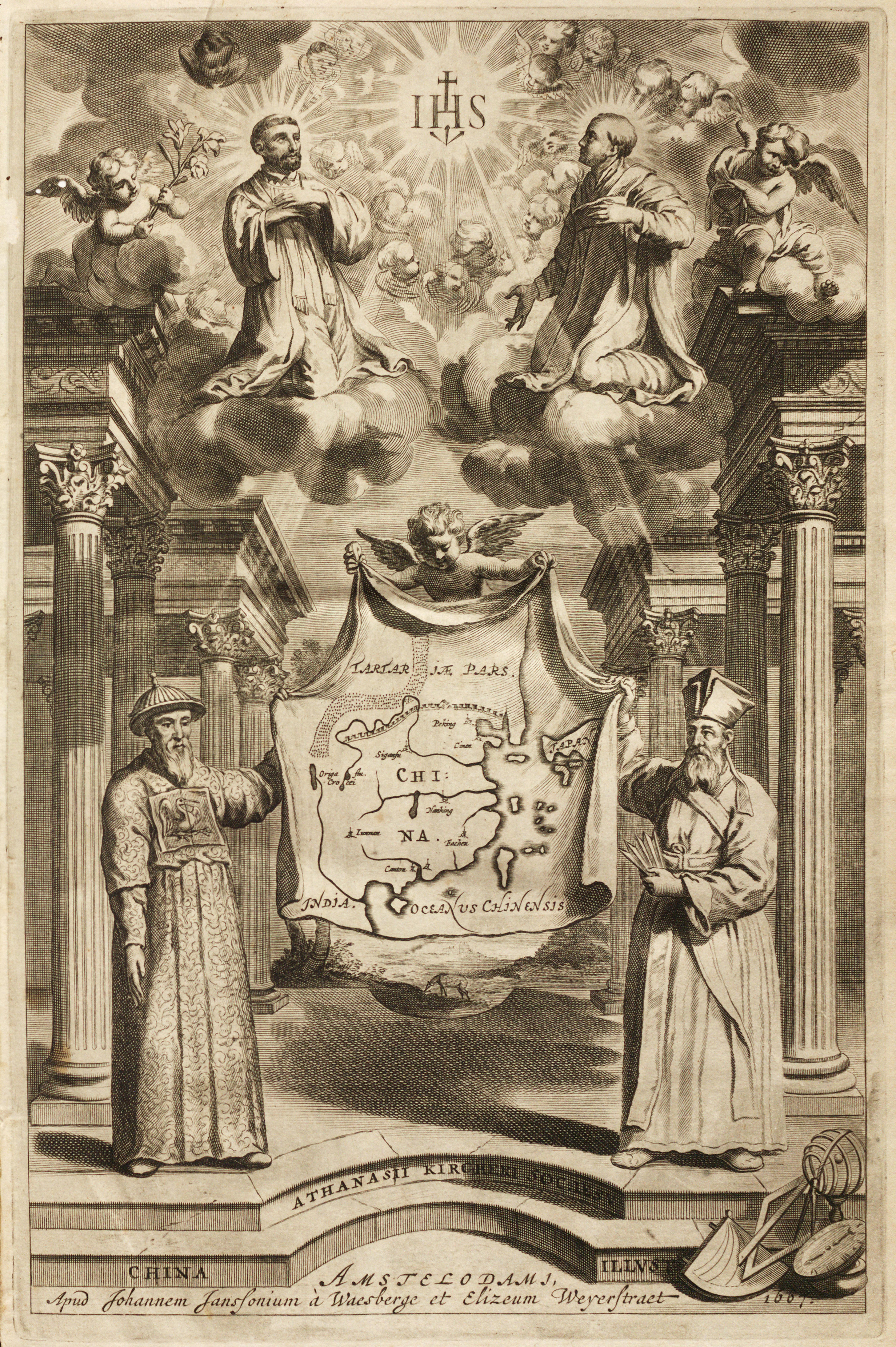
Frontispiece depicting Adam Schall and Matteo Ricci holding a map of China.jpg - Shizhao

Political Map of 19th Century China(時局全圖).jpg - Stewart
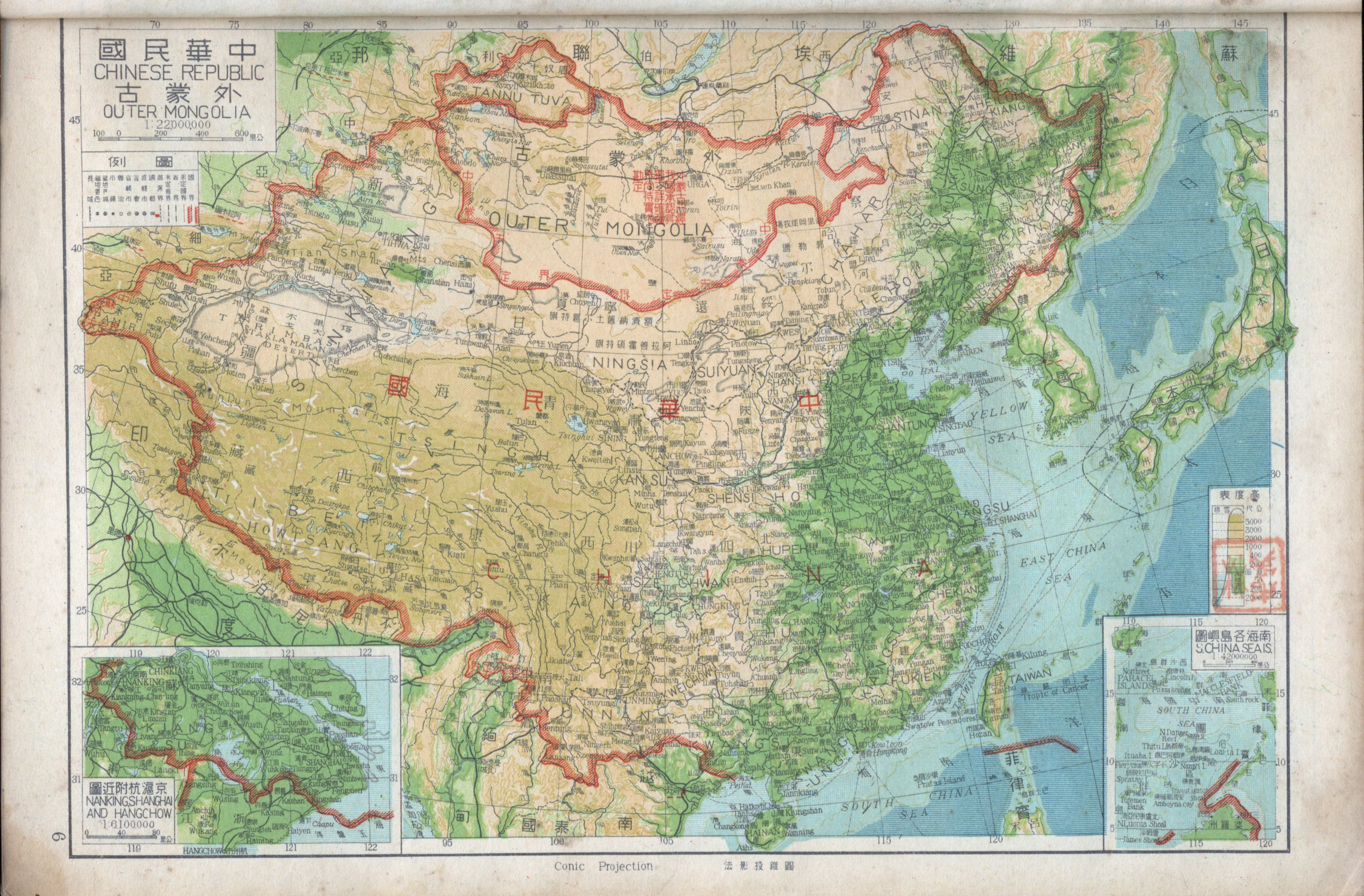
1947 Zhonghua Minguo Quantu.png - Tm
History of Taiwan bg.png - PhiLiP
China Monumentis, qua sacris qua profanis by Athanasius Kircher.jpg - Spinster
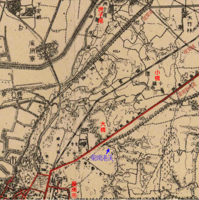
Tainan and Shokyo Map 1941.png - Koika

1930 Map of the Republic of China.JPG - 43tthsrxnj

中山传信录往琉球A.jpg - Ixioini

中山传信录往琉球2.jpg - Ixioini

1837 Malte-Brun Map of China and Japan - Geographicus - China-mb-1837.jpg - BotMultichill

1934 Showa 9 Panoramaic Map of Japan, Korea, Taiwan and Manchuria - Geographicus - Railguide2-japan-1934.jpg - BotMultichillT
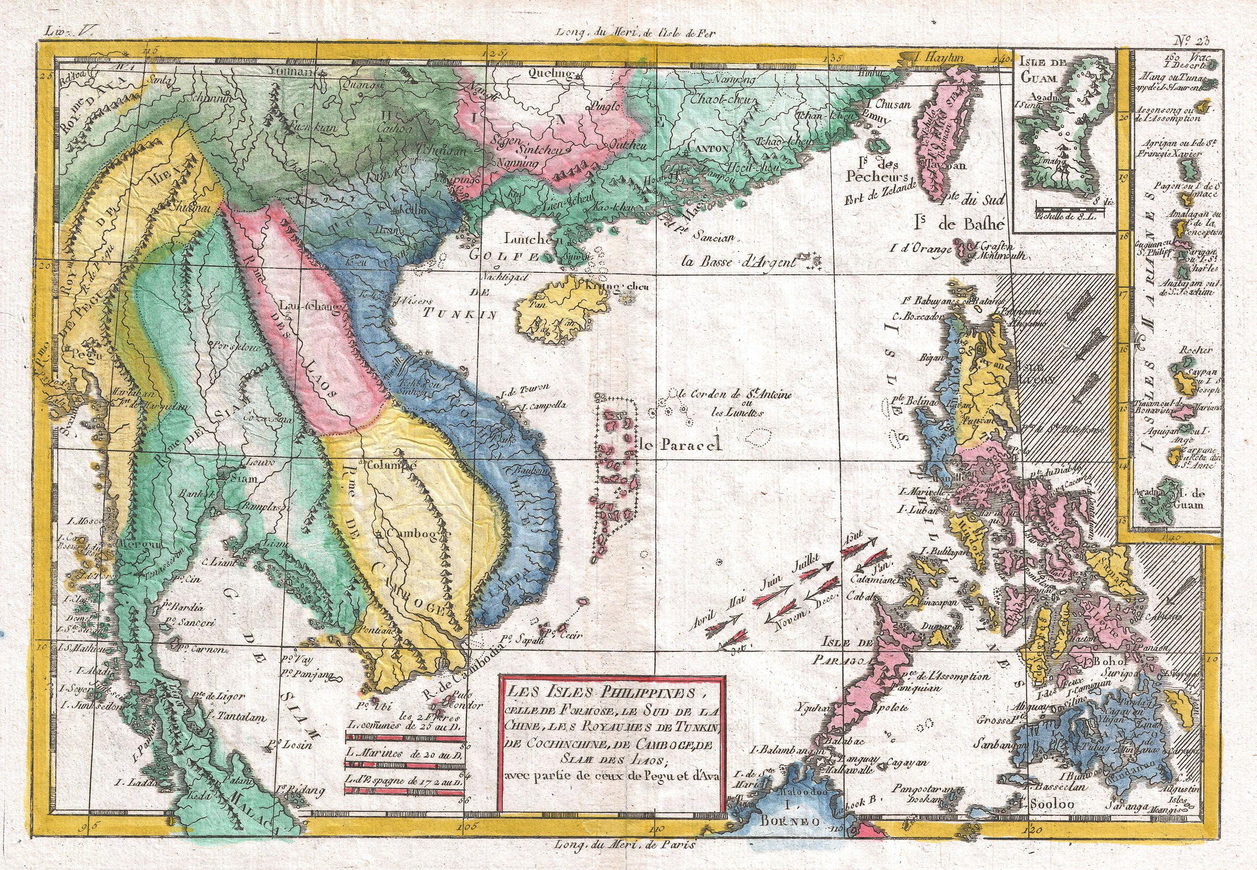
1780 Raynal and Bonne Map of Southeast Asia and the Philippines - Geographicus - Philippines-bonne-1780.jpg - BotMultichillT

鳳山無線通信所平面圖.jpg - Pbdragonwang
Qing Dynasty Map durnig Xinhai Revolution.JPG - Alexchris

Anville Nouvel atlas de la Chine - Page26 Fo kien.jpg - Wuyouyuan

Nationalist government of Nanking - nominally ruling over entire China, 1930 (2675972715).jpg - File Upload Bot (Magnus Manske)

Frontispiece to China illustrated by Athanasius Kircher..JPG - Hmdpsych
A large draught of the coast of CHINA from Amoye to Chusan with harbour of Amoye at large NYPL1640635.tiff - Fæ

AMH-5649-KB Map depicting the journey by Joan Nieuhoff from Canton to Peking.jpg - HuskyBot

1934 Showa 9 Panoramaic Map of Japan, Korea, Taiwan and Manchuria - Geographicus - Railguide2-japan-1934-verso reflipped.jpg - Storkk

MACLEOD(1819) p045 CHART OF THE EASTERN AND YELLOW SEAS.jpg - Metilsteiner

China Proper 1944.png - LlywelynII
STANFORD(1917) p12 Index map (14783818285).jpg - Metilsteiner

STANFORD(1917) p19 PLATE 2. FUKIEN (14803676033).jpg - Metilsteiner

Scottish geographical magazine (1885) (14778913044).jpg - SteinsplitterBot

Athanasii Kircheri... China monumentis (1667) "Frontispicio" (22629197626).jpg - Tm

1944 China (30583362020).jpg - Mindmatrix
A Map of Formosa by Psalmanazar.jpg - Sunshine567

56 of 'The Eastern Seas- being a narrative of the voyage of H.M.S. “Dwarf” in China, Japan, and Formosa. With a description of the coast of Russian Tartary and Eastern Siberia ... With map and illustrations' (11111232604).jpg - SteinsplitterBot

319 of 'Intimate China. The Chinese as I have seen them ... With ... illustrations' (11251997395).jpg - Artix Kreiger 2

47 of 'Pioneering in Formosa, etc' (11246063295).jpg - Artix Kreiger 2

亚新地学社1936年《袖珍中华全图》--04全国政区.jpg - 瑞丽江的河水
Earthquakes in Taiwan. LOC 97681316.tif - Fæ

Earthquakes in Taiwan. LOC 97681316.jpg - Fæ
Map showing the Island of Formosa and the adjoining coast of China. LOC 84696329.tif - Fæ

Map showing the Island of Formosa and the adjoining coast of China. LOC 84696329.jpg - Fæ
Colton's China. LOC 2006629408.tif - Fæ

Colton's China. LOC 2006629408.jpg - Fæ
China, Taiwan Province (Formosa) LOC 2013591166.tif - Fæ

China, Taiwan Province (Formosa) LOC 2013591166.jpg - Fæ
Shajō no byōchi - chizu ni iwayuru Rōkyōwan nari = Sialiao anchorage - the Liang Kiau Bay of the maps. LOC 2011517762.tif - Fæ

Shajō no byōchi - chizu ni iwayuru Rōkyōwan nari = Sialiao anchorage - the Liang Kiau Bay of the maps. LOC 2011517762.jpg - Fæ

Regni Sinae vel Sinae Propriae Mappa et Descriptio Geographica.jpg - Higgenhorscht

台灣上水道分布圖.jpg - CartoDD897

臺灣都市計畫一覽圖.jpg - CartoDD897

Taiwan Forestplan.jpg - CartoDD897

Map of Tibet with Koko Nor (Amdo) about the year 1750 from Regni Sinae vel Sinae Propriae Mappa et Descriptio Geographica (cropped).jpg - Tibet Nation

Map of Tibet with map of India and map of China, World around 1900 (cropped).jpg - Tibet Nation
Atlas général de la Chine, de la Tartarie chinoise, et du Tibet - pour servir aux différentes descriptions et histoires de cet empire LOC 00552972-10.tif - Fæ

Atlas général de la Chine, de la Tartarie chinoise, et du Tibet - pour servir aux différentes descriptions et histoires de cet empire LOC 00552972-10.jpg - Fæ

北白川宮能久攻台地圖.jpg - CartoDD897

Map of Formosa (Taiwan) in 1917 from- STANFORD (1917) p19 PLATE 2. FUKIEN (14803676033) (cropped).jpg - Tibet Nation

Taiwan map detail, from- Qing Dynasty Map durnig Xinhai Revolution (cropped).JPG - Tibet Nation
Map of Taiwan "Formosa" in 1917, from- STANFORD(1917) p12 Index map (14783818285) (cropped).jpg - Tibet Nation

Formosa map in 1902 Encyclopædia Britannica - Volume 34 - Maps (page 195 crop).jpg - Tibet Nation

Admiralty Chart Catalogue 1967 Page 071 Index K1.jpg - Kognos

1960 map “COMMUNIST CHINA TERRITORIAL ORGANIZATION” DA Pamphlet 30-51 Handbook on the Chinese Communist Army - (page 21 crop).jpg - Ooligan

Stations of “THE CHINA INLAND MISSION” 1907 map of China, Tibet, Formosa and Mongolia -(djvu) - The Chinese Empire. A General & Missionary Survey (page 551 crop).jpg - Ooligan

臺灣蕃地圖.jpg - X meta

臺灣蕃族分布圖.jpg - X meta

British Library digitised image from page 70 of "From Far Formosa. The island, its people and missions ... Edited by J. A. Macdonald, etc".jpg - SSJF01

British Library digitised image from page 705 of "Narrative of the Expedition of an American Squadron to the China Seas and Japan, performed in the years 1852, 1853 and 1854, under the command of Commodore M. C. Perry ... by order of th.jpg - SSJF01

Province de Fo-Kien. 250 lis ou stades chinois, 25 lieues françoises (=Om. 055 ; 1 - 2 000 000 environ) - Le Parmentier sculp - btv1b53057962z.jpg - Gzen92Bot
Province de Fo-kien - (d'Anville) ; Le Parmentier sculp - btv1b59730438.jpg - Gzen92Bot

Province de Fo-kien - (tirée du P. Duhalde) ; Le Parmentier Sculp. - btv1b5963075z.jpg - Gzen92Bot

Nouvel Atlas de la Chine, de la Tartarie chinoise et du Thibet contenant les cartes générales et particulières de ces pays, ainsi que la carte du royaume de Corée, la plupart levées sur les lieux... - btv1b53096745m (029 of 117).jpg - Gzen92Bot

Province de Fo-kien - (tirée du P. Duhalde) - btv1b5963076c.jpg - Gzen92Bot

Description de la Chine - par Lu-Ying-Yang, rédigée en 1686 - btv1b53170136z (0064 of 1602).jpg - Gzen92Bot

Fo-Kien Province de Fo-Kien - (par J.-B. d'Anville.) - btv1b8468746m.jpg - Gzen92Bot

Ile Formose - btv1b53233309w.jpg - Gzen92Bot

Map of Mongolia, Sinkiang, Tibet and China from within Compton's Pictured Encyclopedia (1922).jpg - Ooligan

Admiralty Chart No 3236 Okinawa Gunto to Formosa, Published 1948.jpg - Kognos

Admiralty Chart No 2376 Plans and Anchorages in Formosa, Published 1932.jpg - Kognos

Admiralty Chart No 1968 Tai-Wan and Strait, Published 1966.jpg - Kognos

Admiralty Chart No 3804 Luzon Strait, Published 1925.jpg - Kognos