Wikimedi'Òc
Modes d'emploi

Cet album fait partie des albums
Cet album photos contient les sous-albums suivants :


Maps of Incan Peru, of Florida, and of Guastecan (i.e. part of Mexico) by Abraham Ortelius.jpeg - File Upload Bot (Kaldari)
East and West Florida 1810.jpg - Sebastian Wallroth

Spanish Florida Map 1803.jpg - Jan Kronsell

West Florida Map 1767.jpg - Jan Kronsell

Cartografía de los Reinos del Perú, Nueva Granada, la Florida y el Este de México (1587) - AHG.jpg - Jojagal
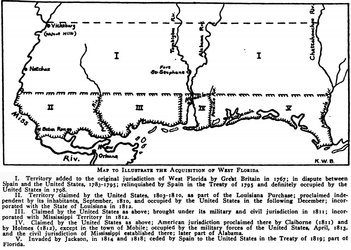
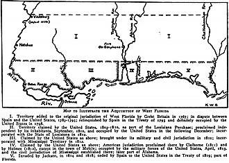
Map to Illustrate the Acquisition of West Florida.jpg - Jeff in CA

1822 Geographical, Statistical, and Historical Map of Florida by Henry Charles Carey, Isaac Lea and Fielding Lucas.png - Jeff in CA

Plano de la Ciudad y Puerto de San Agustin de la Florida (8900730155).jpg - Fæ

Plan de la Baye de Pansacola (8802195415).jpg - Fæ

"A View of the Town and Castle of St. Augustine, and the English Camp before it June 20 1740" (9124092669).jpg - Fæ

"Florida et Regiones Vicinae" (9124298123).jpg - Fæ

Confirmed Spanish Land Grant of Joseph M. Hernandez (8959152402).jpg - Fæ

Côtes des environs de la rivière Mississippi en 1701.jpg - AYE R

EB9 United States - historical maps (top).jpg - Bob Burkhardt

Homann Amplissimae Regionis Mississipi c. 1720 UTA.jpg - Michael Barera

A View of the Town and Castle of St. Augustine, and the English Camp before it June 20, 1740 - The Gentleman's Magazine, 1740.jpg - Broichmore