Wikimedi'Òc
Modes d'emploi

Cet album fait partie des albums
Cet album photos contient les sous-albums suivants :


Plan of the Cataraqui Creek from Brewers Lower Mill to Kingston Mills.jpg - Geo Swan
John Burrows’ survey sketch (looking south) of Cox’s, Nicholsons’ and Clowes’ rapids on the Rideau River in 1827.jpg - Geo Swan

Merrickville Locks - 1829.jpg - Geo Swan

The Route of the Rideau Canal, 1830.jpg - Geo Swan

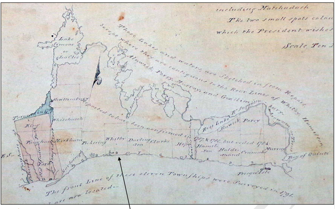
Carte des pays situes à l'ouest du Canada 1791.jpg - Mindmatrix

P025 - N° 524. Canada Oriental. - Liv4-Ch05.png - Vieux têtard

Annual report of the Fruit Growers' Association of Ontario, 1901 (1902) (19364284255).jpg - SteinsplitterBot

Annual report (1903) (17808020573).jpg - Faebot

Documents de la session de la Puissance du Canada- 1901, (Volume 35, no.8, Documents de la session 19 à 20) (1901) (14781700231).jpg - SteinsplitterBot

Documents de la session de la Puissance du Canada- 1901, (Volume 35, no.8, Documents de la session 19 à 20) (1901) (14598142330).jpg - SteinsplitterBot

Annual report of the Fruit Growers' Association of Ontario, 1902 (1903) (14746933846).jpg - SteinsplitterBot

Ontario Sessional Papers, 1918, No.47-49 (1918) (14583644767).jpg - Fæ

Ontario Sessional Papers, 1907, No.45-74 (1907) (14766448582).jpg - SteinsplitterBot

Ontario Sessional Papers, 1914, No.3-9 (1914) (14580084177).jpg - SteinsplitterBot

The Pan-American geologist (1894) (14767265475).jpg - Fæ

26 of 'Onondaga; or, Reminiscences of earlier and later times; being a series of historical sketches relative to Onondaga; with notes on the several towns in the county, and Oswego. (With portraits and a map.)' (11030111593).jpg - Artix Kreiger 2

338 of 'The Township of Scarboro, 1796-1896. Edited by David Boyle. (With plates.)' (11236039406).jpg - Artix Kreiger 2

39 of 'Muskoka through a Camera; an album of the Muskoka Lakes' (11250589536).jpg - Artix Kreiger 2

A map of the north west parts of America, with the utmost respect, inscrib'd to His Excellency, Sir Guy Carleton, Knight of the Bath- Captain General and Governor of the province of Quebec- General LOC 74694753.jpg - Fæ

Map of the Toronto Carrying Place (1619-1793), which was the portage route from the Holland Marsh to Lake Ontario.jpeg - Geo Swan

Position of beaches of proglacial lakes that preceded the North American Great Lakes.jpg - Geo Swan

Province of Canada, 1850.webp - Geo Swan

Rouge Trail Map 1673 Louis Jolliet 1673.png - Ras67

Map of Sarnia and Point Edwards, 1880.jpg - Geo Swan

Map of the north shore of Lake Huron, in Sarnia Township, with Point Edwards to the west and Cow Creek to the east, 1880 (cropped).jpg - Geo Swan

Site of UWO's medical complex, from a detail of page 28 from the Fire Insurance Map of London drawn in 1881 and corrected to 1888.png - Geo Swan

1877OntarioCounty.jpg - Majorville
Genticore plate, Upper Canada.png - SteinsplitterBot
Grand-River-Niagara-Part2.tif - Geo Swan
Grand-River-Niagara-Part1.tif - Geo Swan
Erie Welland Canals-1850.tif - Geo Swan
WellandCanal1833.tif - Geo Swan

StCatharines-1809.jpg - Geo Swan
StCatharines-1809.tif - Geo Swan

Port Dalhousie in 1876.jpg - Geo Swan
Port Dalhousie in 1876.tif - Geo Swan

NOTL-StC-25k-1937.jpg - Geo Swan

Canada Department of Mines. Geological Survey. Map 276 A. Thunder Bay silver area, Thunder Bay district, Ontario. 1 - 253 440 (Geology) - btv1b53204326s.jpg - Gzen92Bot

Canada Department of Mines. Geological Survey. Geological map of portions of the districts of Algoma and Thunder Bay, Ontario, to illustrate reports by W.J. Wilson... and W.H. Collins... 1903-05. 1 - 506 880... - btv1b53204324w.jpg - Gzen92Bot

Geological and Natural History Survey of Canada. Province of Ontario. Geological and topographical map of the Silver Mountain mining district, by Elfric Drew Ingall - btv1b53204297r.jpg - Gzen92Bot

Canada Department of Mines. Bureau of Economic Geology. Geological Survey. Map 334 A.Mines Centre area, Rainy River district, Ontario. 1 - 31 680 - Geology by T.L.Tanton, 1934 - btv1b532043008.jpg - Gzen92Bot

Canada Department of Mines. Geological Survey. The Ontario peninsula... Geology by M.Y. Williams... - btv1b53204317t.jpg - Gzen92Bot

Old map of Trenton, Ontario (52979205104).jpg - Geo Swan