Wikimedi'Òc
Modes d'emploi

Cet album fait partie des albums
Cet album photos contient les sous-albums suivants :


Pope1880Beluch2.jpg - MALLUS

Joppen1907India1805a-21.jpg - Trotting cove

Map India and Pakistan 1-250,000 Tile NI 43-6 Srinagar and Vicinity (verso).jpg - Slick-o-bot

Ladakh 1792.jpg - Shyamal

Ladakh 1733.jpg - Shyamal

1912 China map from National Geographic.jpg - Scewing

1894 Bagrot Hunza Nagyr and Hispar Glacier by Conway.jpg - Thincat
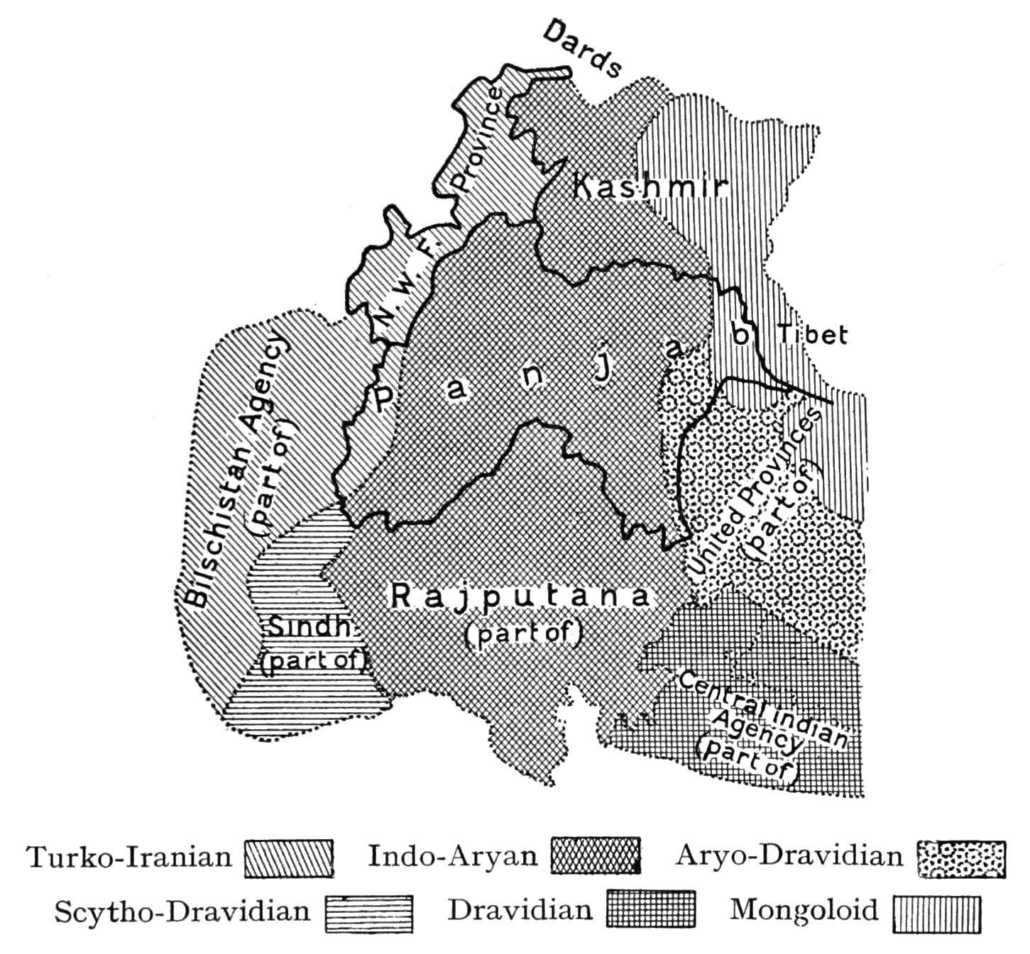
Provincial Geographies of India Volume 1 0129.jpg - Moondyne

The Quarterly journal of the Geological Society of London (14154902110).jpg - FlickreviewR 2

Aksai Chin and the valley of the Karakash in Ladakh, eastern Kashmir comprising the area from the eastern Pang gong lake in Ladakh in the bottom to the Kilian, Sanju-la and Hindutash Passes in Ladakh in the Kue.png - Hindutashravi

Area of Kashmir.png - Hindutashravi

16 of 'The Adventures of a Lady in Tartary, Thibet, China, and Kashmir. ... With an account of the Journey from the Punjab to Bombay overland. ... Also an account of the Mahableshwur and Neilgherry Mountains, etc' (11041620475).jpg - Artix Kreiger 2

143 of 'The Diary of a Hunter from the Punjab to the Karakorum Mountains' (11064809954).jpg - Artix Kreiger 2

178 of 'The Earth and its Inhabitants. The European section of the Universal Geography by E. Reclus. Edited by E. G. Ravenstein. Illustrated by ... engravings and maps' (11122715684).jpg - Artix Kreiger 2

179 of 'The Earth and its Inhabitants. The European section of the Universal Geography by E. Reclus. Edited by E. G. Ravenstein. Illustrated by ... engravings and maps' (11123660505).jpg - Artix Kreiger 2

Map of the Northern Part of the Punjab and of Kashmir (13305002).jpg - Yann

Kashmir Map.jpg - Shyamal

Map of Kashmir, Kalhana's Rajatarangini, A Chronicle of the Kings of Kashmir, Marc Aural Stein.jpg - Junaid.ksn

Pleistocene Deposits of the Sind Valley Kashmir.jpg - Edit-pi
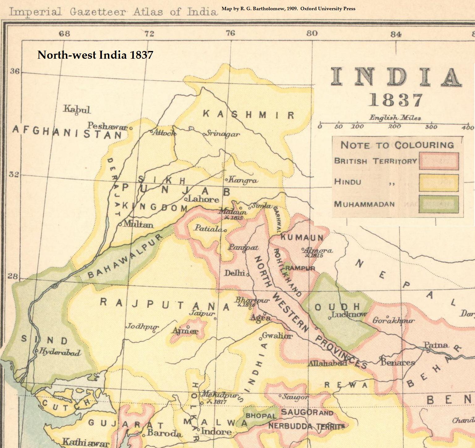
NWIndia 1837 imperial gazeteer.jpg - I love rpgs

Caboul Peshawer from Asie 1 to 1,000,000. flle 36N-72E.jpg - Balkanique

Djammou-Kachmir from Asie 1 to 1,000,000. flle 36N-78E.jpg - Balkanique

Map of Tibet in 1821 Carey Map of India - Geographicus - India-carey-1821 (cropped).jpg - Tibet Nation

Darel-Tangir-Chilas.png - Kautilya3

Maps of Tibet, Nepal and Bhutan, from- Stanford's map of the empires of China and Japan with the adjacent parts of the Russian Empire, India, Burma etc. LOC 2006458442 (cropped).jpg - Tibet Nation

"TIBET" "PETIT TIBET" (Little Tibet) "KASHMIR" "PENGAB" (Punjab) map detail from- 1770 Bonne Map of Northern India, Burma and Pakistan - Geographicus - IndiaNorth-bonne-1770 (cropped).jpg - Tibet Nation

Map of Tibet in 1905, from- 079 ostindien (1905) (cropped).png - Tibet Nation

Chah-i-Doulla (Shahidulla) and environs 1 - French Army map.jpg - Kautilya3

Map of Tibet- "TIBET CONFIDENTIAL" "Ethnographic Boundary of Tibet" "Approximate Line of Communist Advance" and "Reportedly occupied by Communists" "11518, CIA, 2-50" February 1950 map- 305945 11518 01 (cropped).jpg - Tibet Nation
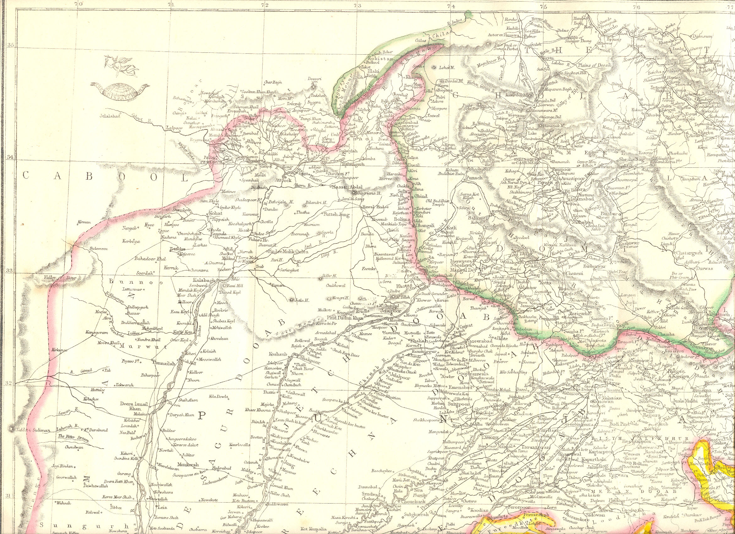
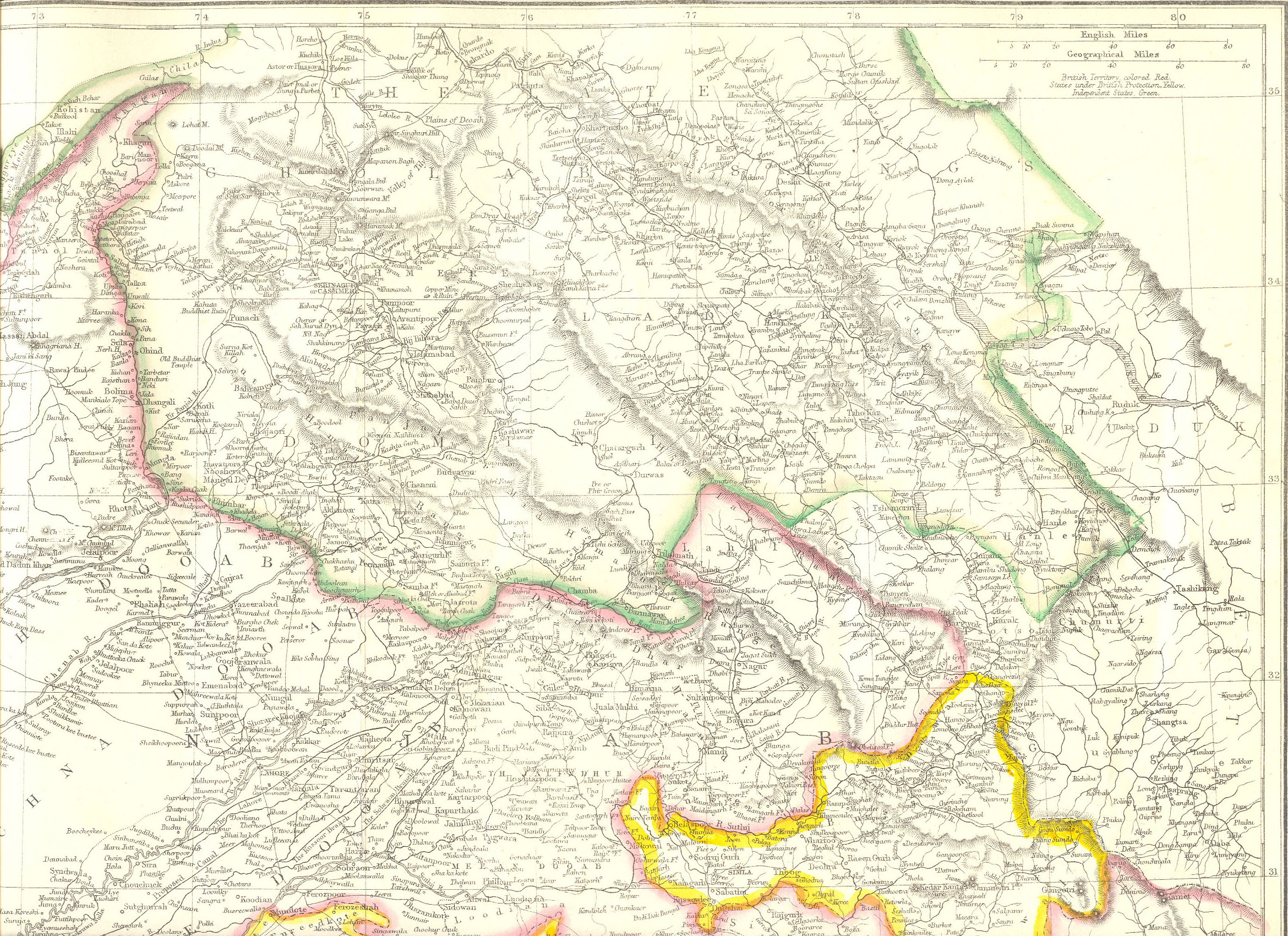
Punjab-NWFP-Kashmir-1863.jpg - Kautilya3

Tibet and East Turkestan 1902 map, from- 1902 Encyclopædia Britannica - Volume 34 - Maps (page 186 crop).jpg - Tibet Nation

Jammu and Kashmir in 1954 Political Map of India.jpg - Kautilya3

1940 Kashmir Jammu and Gilgit Agency by Survey of India.jpg - Kautilya3

Txu-pclmaps-oclc-181831961-52-b-kargil-1946.jpg - Kautilya3

Txu-pclmaps-oclc-181831961-dras-43-n-1958.jpg - Kautilya3

Txu-pclmaps-oclc-181831961-42-n-dras-1923.jpg - Kautilya3

1923 SoI map of Dras Marpola Shingo.jpg - Kautilya3

Txu-pclmaps-oclc-181831961-52-b-kargil-1928.jpg - Kautilya3

Sheet No 43 Srinagar by Survey of India (1916).jpg - Shyamal

Map of Aksai Chin in Ladakh depicting Shahidullah, the Hindu-tash Pass and the Kara Kash river in Kashmir.jpg - Hindutashravi

Jammu and Kashmir in 1909 map from the Imperial Gazetteer.jpg - Kautilya3

Jammu and Kashmir in 1888 Survey of India map.jpg - Kautilya3

"Map of Rajasthan and the Panjab" 1916 map, Oxford University Press, (includes Tibet Punjab, Kashmir, Gujarat, Rajasthan) - Getty Research Institute (IA rajputpaintingbe01coom) (page 22 crop).jpg - Ooligan

North-Western India in 1946 map of India by National Geographic.jpg - Kautilya3

Map of Kashmir, Ladak and Little Tibet and of the countries between the Sutley and the Oxus... - compiled by the order of the Court of Directors of the East India Company by John Walker - btv1b53029897t (1 of 2).jpg - Gzen92Bot

Map of Kashmir, Ladak and Little Tibet and of the countries between the Sutley and the Oxus... - compiled by the order of the Court of Directors of the East India Company by John Walker - btv1b53029897t (2 of 2).jpg - Gzen92Bot

Txu-pclmaps-oclc-181831961-52-b-ladakh-1916.jpg - Kautilya3

Kashmir-Kayhan.jpg - Yoosef Pooranvary

The Quarterly journal of the Geological Society of London, Volume XXXIV, Plate XIV.jpg - User-duck

Map of Central Asia to Accompany the Paper by Captn H Trotter RE.png - LlywelynII

Map of the Valley of Kashmir, copied from materials furnished by W. Murray, by A. Gerard, 1840 (F08-24).jpg - MaplesyrupSushi

Map of Kashmir, drawn by J. O. N. James, 1861 (F08-25-1).jpg - MaplesyrupSushi

Map of Kashmir, drawn by J. O. N. James, 1861 (F08-25-2).jpg - MaplesyrupSushi

Map of Kashmir, drawn by J. O. N. James, 1861 (F08-25).jpg - MaplesyrupSushi

Map of Kashmir, drawn by J. O. N. James, 1861 (F08-25-3).jpg - MaplesyrupSushi

Map of Punjab (East) and Kashmir, from the 'Atlas of India', published by W. & A.K. Johnston, 1894 (full).jpg - MaplesyrupSushi

Kashmir, Indian Atlas, sheet 28 (15198000).jpg - Yann
Ladakh-Garhwal-1863.jpg - Kautilya3