Wikimedi'Òc
Modes d'emploi

Cet album fait partie des albums


Chart of the coasts of Guzarat and Scindy from various materials - by Dalrymple ; W. Harrison fc. - btv1b85931217.jpg - Gzen92Bot

Chart of the coast of Guzarat from a french MS. communicated in 1760 by Mr. Swithin - W.H. - btv1b8593129j.jpg - Gzen92Bot

Plan of Gogo in the Gulph of Cambay from a book of MS. charts - by M. Hunter ; W.H. - btv1b8593134v.jpg - Gzen92Bot

Plan of Nunsaree river, Lat. 20°50' N. - by John Ringrose ; (gravé par) WH - btv1b532583866.jpg - Gzen92Bot

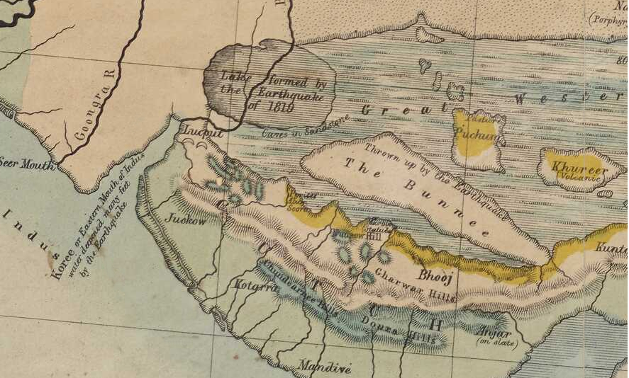
Gujarat coast.jpg - Shyamal

Plan of Gundivee river, Lat 20°37' N - by John Ringrose ; from Governor Hornby's collection ; (gravé par) WH - btv1b53258383v.jpg - Gzen92Bot

Plan of Gundivee river, Lat 20°37' N - by John Ringrose ; from Governor Hornby's collection ; (gravé par) WH - btv1b53258382d.jpg - Gzen92Bot

Plan of Bulsaur river, Lat. 20°30' N. ; Plan of Omersary river, Lat. 20° 26' N. - by Lieut.t John Ringrose ; (gravé par) W. H. - btv1b53258385r.jpg - Gzen92Bot

Chart of the bay of Coche and river Nagor, on the coast of Guzzaratt - by Charles Massey ; W. Harrison fc. - btv1b85931284.jpg - Gzen92Bot
Gulf of Cambay, A map of the Presidency of Bombay in 1775 (published in a history of India, 1898).jpg - Baddu676

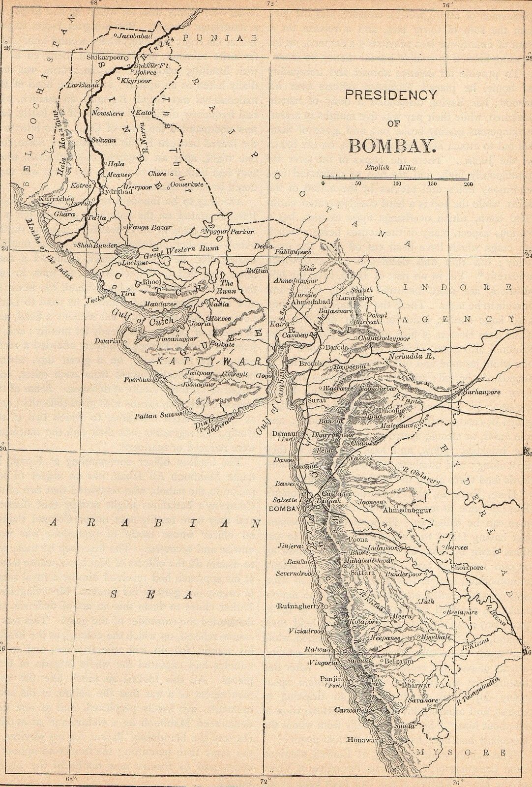
Pope1880BombayPres2.jpg - MALLUS

Chart of part of the coasts of India and Guzarat - by John Mc Cluer, 1788 ; W. Harrison - btv1b53257818r.jpg - Gzen92Bot

Plan of Jaffrabat on the coast of Guzarat Lat. 20° 51' N. - by John Mc Cluer, 1788 ; W. Harrison ; J. Walker sculp.t - btv1b53261838t.jpg - Gzen92Bot

Plan of Searbett island Lat. 20° 55' 30" N. and Chanch river on the coast of Guzarat - by John Mc Cluer, 1788 ; W. Harrison ; J. Walker sculp.t - btv1b53261837c.jpg - Gzen92Bot

Sketch of Rajapora on the southern coast of Guzarat ; Sketch of Nowa Bunder on the southern coast of Guzarat - by A. Blair, 1795 - btv1b532618398.jpg - Gzen92Bot

GADHADA-TALUKA MAP (Guj A).jpg - Ashok modhvadia

SIHOR-TALUKA MAP (Eng A).jpg - Ashok modhvadia
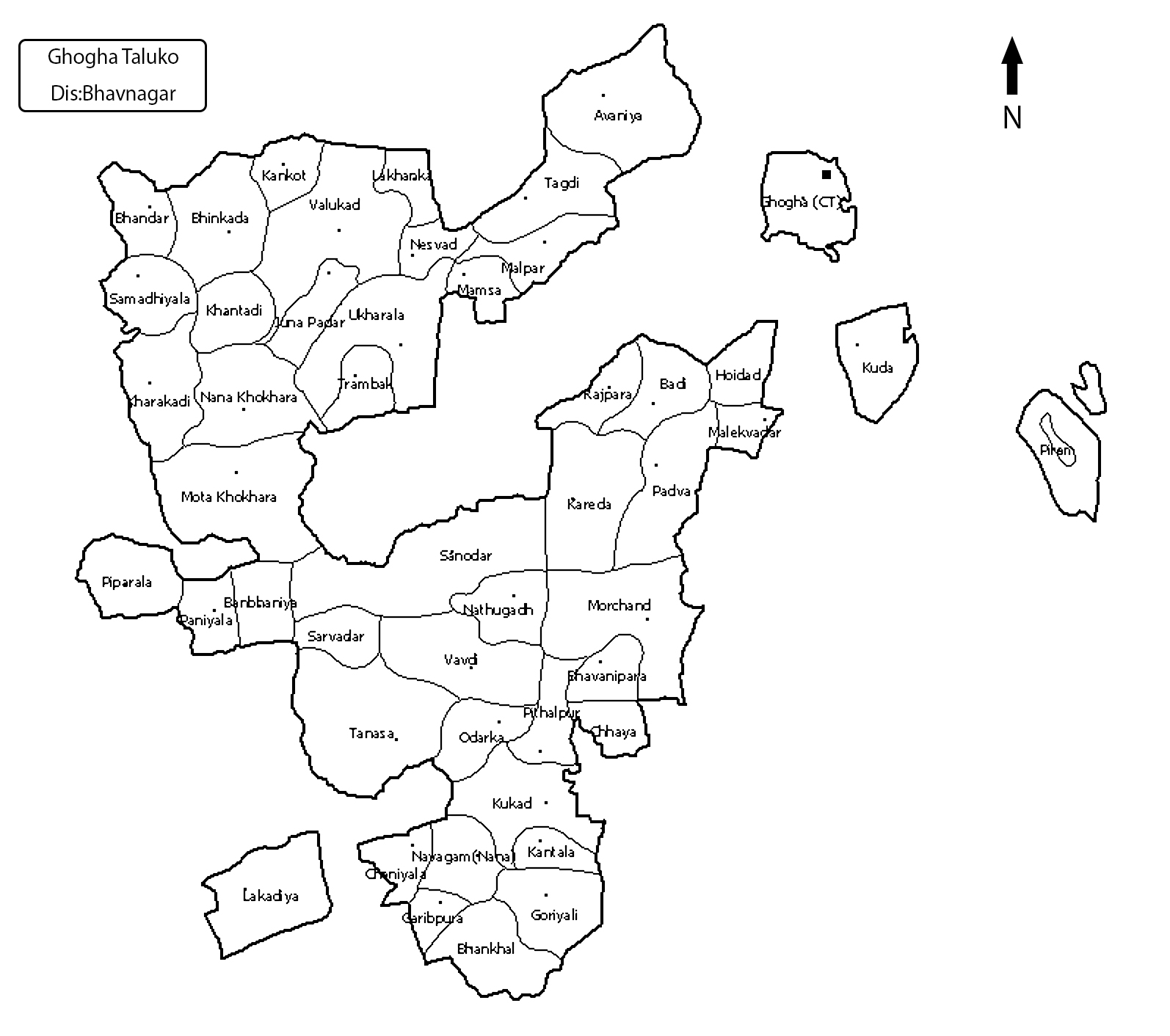
GHOGHA-TALUKA MAP (Eng A).jpg - Ashok modhvadia

RANPUR-TALUKA MAP (Eng A).jpg - Ashok modhvadia

MAHUVA-TALUKA MAP (Eng A).jpg - Ashok modhvadia

DETROJ-TALUKA MAP (Eng A).jpg - Ashok modhvadia

Early Gujarat.jpg - Shyamal

Map of Goozerat Gujarat 1866.jpg - Nizil Shah

Mahi Kantha Agency British India map 1878.jpg - Nizil Shah

Cutch State British India 1878.jpg - Nizil Shah
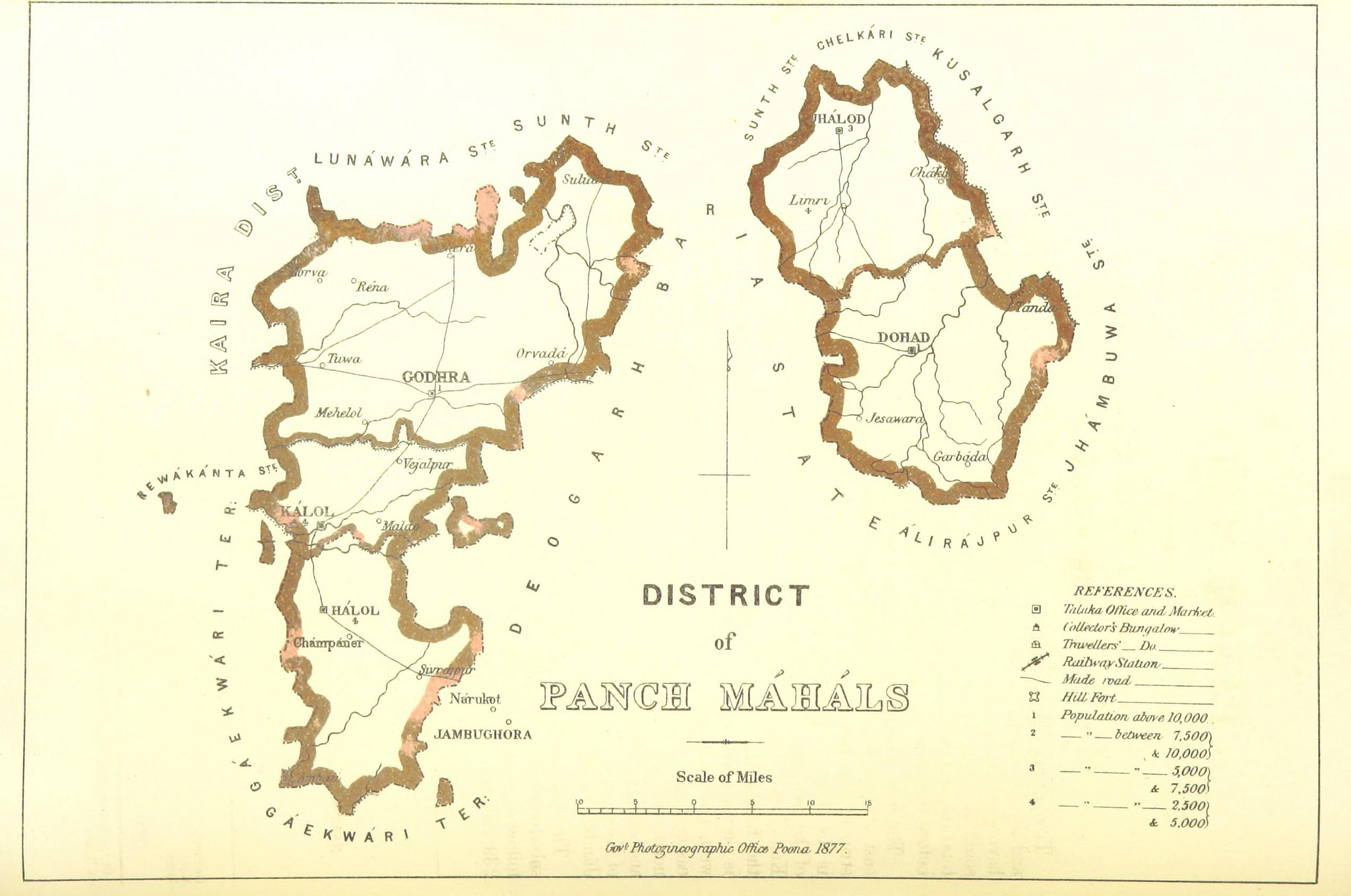
Panchmahal district British India 1896.jpg - Nizil Shah

Early Gujarat (BC 250 to 1300 AD).jpg - Nizil Shah
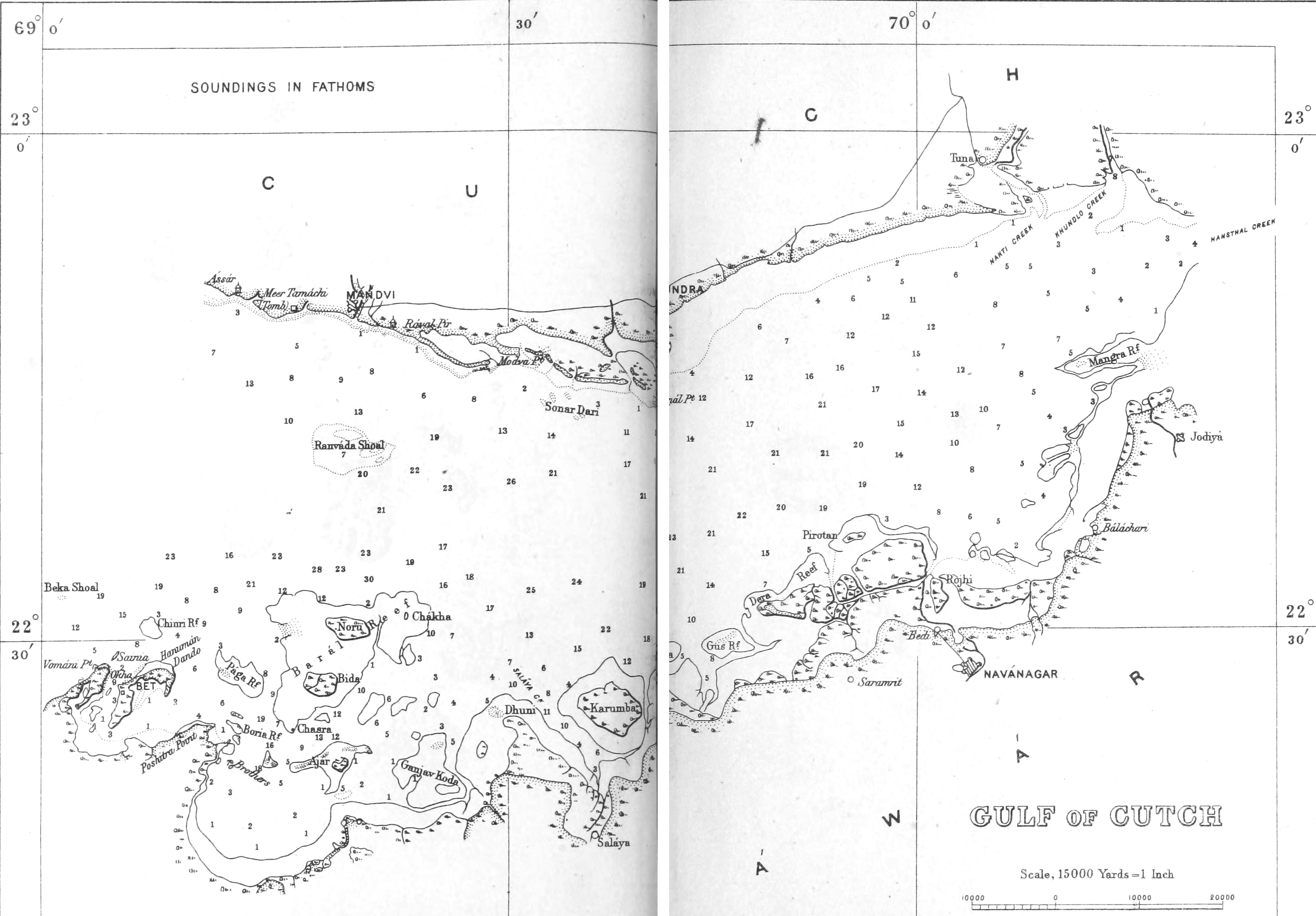
Gulf of Kutch 1896.png - Nizil Shah

Province of Guzerat Gujarat India 1896.jpg - Nizil Shah

Map of Gulf of Cambay, A map by Petrus Bertius, Amsterdam, 1606.jpg - Baddu676

The Commerce and Navigation of the Ancients in the Indian Ocean - Gujarat and Sindh coast.jpg - Nizil Shah
Gujarat Geological map.jpg - Shyamal

View of Surat, 1685.jpg - Baddu676

A closeup of the Punjab and Gujarat from "L'Atlas en Abrege ou Nouvelle Description du Monde," .jpg - Baddu676

Gulf of Khambhat - to get a sense of map detail consider that the distance from Chittaurgarh (here shown as "Chitor") to Burhanpur (here shown as "Brampore") at lower right.jpg - Baddu676

Kathiawar geology.jpg - Shyamal

Kutch geology.jpg - Shyamal

Surrat City by William Hack.jpg - Ttocserp

1946 map of Kathiawar Peninsula by National Geographic.jpg - Kautilya3

Sheet-18-baroda and diu-1914.jpg - Sbb1413

Sheet-41-baroda-and-diu-1915.jpg - Sbb1413

Admiralty Chart No 775 Gundivee River, Published 1783.png - Kognos

Admiralty Chart No 774 Nunsaree River, Published 1784.jpg - Kognos

Admiralty Chart No 776 Bulsaur and Omersary Rivers, Published 1784.jpg - Kognos

Admiralty Chart No 764 Rajapora and Nowa Bunder Roads, Published 1790.jpg - Kognos

Map of Gujrat District, 1853–55, drawn by G. Potenger, reduced from the original in 1859 (F.5-11).jpg - MaplesyrupSushi

MAPS FROM CONSTABLE'S 1893 HAND ATLAS - 2.jpeg - శ్రీధర్ బబు

"Map of Rajasthan and the Panjab" 1916 map, Oxford University Press, (includes Tibet Punjab, Kashmir, Gujarat, Rajasthan) - Getty Research Institute (IA rajputpaintingbe01coom) (page 22 crop).jpg - Ooligan

The location of Somnath, site of Mahmud Ghaznavi's last and most notorious temple raid, c.1025 6.jpg - Baddu676

Map of railways, telegraphs, and navigable canals of the British Indian Empire, from the Constable's Hand Atlas of India (1893) (Section I).jpg - SteinsplitterBot

Survey of India, 46 C Surat (1943).jpg - Yann

Survey of India, 46 G Nandod (1940).jpg - Yann

Survey of India, 46 H Bansda (1939).jpg - Yann