Wikimedi'Òc
Modes d'emploi

Cet album fait partie des albums
Cet album photos contient les sous-albums suivants :


1855 Colton Plan or Map of Pittsburgh, Pennsylvania and Cincinnati, Ohio - Geographicus - PittsburghCincinnati-colton-1855.jpg - BotMultichillT

Map Showing Channel Span of the Cincinnati and New Port Bridge - NARA - 128215792.jpg - US National Archives bot

Map Showing Defences of Cincinnati Covington & Newport - NARA - 102279847.jpg - US National Archives bot

The Americana - a universal reference library, comprising the arts and sciences, literature, history, biography, geography, commerce, etc. of the world (1903) (14577016628).jpg - Fæ

The Americana - a universal reference library, comprising the arts and sciences, literature, history, biography, geography, commerce, etc. of the world (1903) (14577005659).jpg - Fæ

Panoramic view, city of Cincinnati, U.S.A. 1900. LOC 75694914.jpg - Fæ

Panoramic view, city of Cincinnati, U.S.A. 1900. LOC 75694914 (3600px).jpg - Retired electrician

Cincinnati-aerial-view-1900 (Mill Creek).jpg - Krib

Cincinnati-aerial-view-1900.jpg - Wholtone

Cincinnati-map-1838.jpg - Wholtone

Atlas Of The USA 1857 (Cincinatti).jpg - Enyavar
Avenue Grounds 1888 map.jpg - Baseball Bugs

Cincinnati 1870.jpg - National Public Domain Archive

Cincinnati part IX embracing 11th & 19th wards. (1869).png - File Upload Bot (Magnus Manske)

EB9 Cincinnati.jpg - Bob Burkhardt

Cincinnati-map-1841.jpg - Wholtone

Americana 1920 Cincinnati.jpg - Library Guy
Plan of Cincinnati and vicinity (NYPL b13663520-1510815).tiff - Fæ

Map of Hamilton County, Ohio, Moessinger & Bertsch (1884) Cincinnati.png - IagoQnsi
Map of Spring Grove Cemetery, adjoining Cincinnati - showing all burial lots with their numbers and sections, as laid out to date, together with about 2000 names of owners of the largest sized lots, LOC 2012586630.tif - Fæ
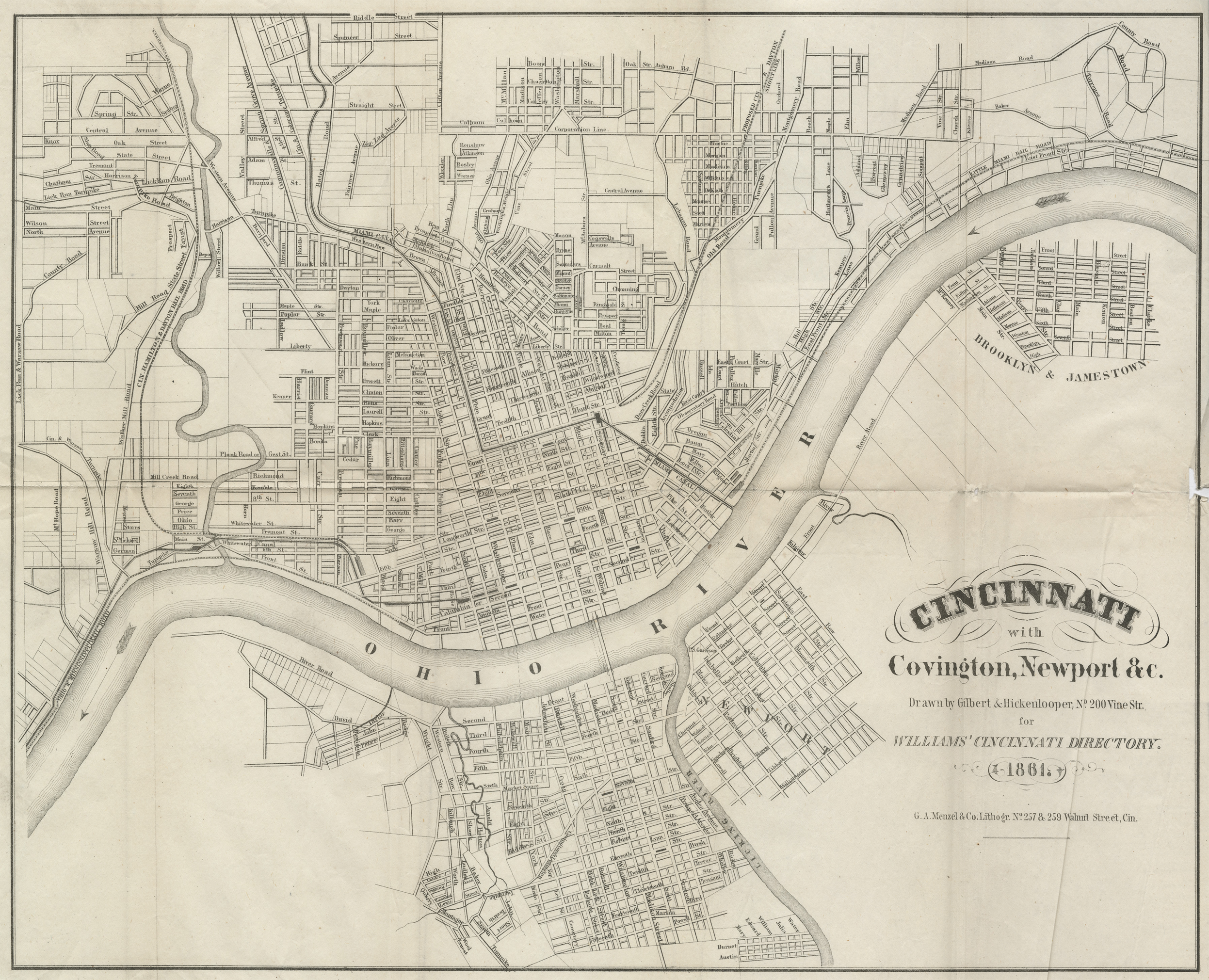
WilliamsCincinnatiDirectory 1861 page 1.png - Jengod

Map showing the military defences of Cincinnati, Covington and Newport LOC 99447487.jpg - Fæ
The cities of Pittsburgh and Allegheny, with parts of adjacent boroughs, Pennsylvania (NYPL b20625668-5365399).tiff - Enyavar

Map of the city of Cincinnati LOC 2004629233.jpg - Fæ

Fort Washington Cincinnati map.png - Roseohioresident

Topographical map of the city of Cincinnati, from actual survey LOC 2006626028.jpg - Fæ

The Lines of the Cincinnati, Newport, and Convington Railway Company c 1894.png - DavidLevinson

Cincinnati - NARA - 26335549.jpg - US National Archives bot

Cincinnati, Ohio 1955 Yellow Book.jpg - SPUI~commonswiki

Cincinnati 1964 - PCL Map Collection - txu-pclmaps-topo-us-cincinnati-1964.jpg - DaxServer

1864 Mitchell Map of Cincinnati. Ohio - Geographicus - Cincinnati-mitchell-1864.jpg - BotMultichill

1846 Burroughs - Mitchell Map of Ohio - Geographicus - Ohio-m-1846.jpg - BotMultichillT

Map of Cincinnati Wellcome L0040478.jpg - Fæ

54 of 'Colton and Fitch's modern School Geography. Illustrated by ... maps, and ... engravings. By G. W. Fitch. Maps ... by G. W. Colton. Revised edition, etc' (11046572243).jpg - Artix Kreiger 2

210 of 'Le Monde vu par les artistes. Géographie artistique. ... Ouvrage orné d'environ 600 gravures et cartes' (11081213706).jpg - Artix Kreiger 2

A Journey in North America, containing a survey of the countries watered by the Mississipi, Ohio, Missouri and other affluing rivers... illustrated by 36 maps, plans, views and divers cuts - by Victor Collot - btv1b530967428 (16 of 40).jpg - Enyavar