Wikimedi'Òc
Modes d'emploi

Cet album fait partie des albums


Situationsplan von Kapstadt.jpg - ¡0-8-15!

Cape Town 1798.jpg - Andrew massyn~commonswiki

Michell map00.jpg - Paul venter

1763 Bellin Map of Cape Town (Cape of Good Hope) South Africa - Geographicus - GoodHope2-bellin-1763.jpg - BotMultichill

1764 Bellin Map of Cape Town (Cape of Good Hope) - Geographicus - GoodHope3-bellin-1763.jpg - BotMultichill

1773 Bellin Map of the Cape of Good Hope, Capetown, South Africa - Geographicus - GoedeHoop-bellin-1773.jpg - BotMultichill

1750 Bellin Map of Cape Town, South Africa - Geographicus - Gundriss-bellin-1750.jpg - BotMultichillT

Map of Cape Town - Cape Colony Arch 1882.jpg - Abu Shawka

Cape Town 1785.jpg - Raymond.ellis

Cape Town 1786.jpg - Raymond.ellis

Camps Bay, Cape Town and Sea Point Electric Tramways map - ca. 1906.jpg - Bahnfrend

Map of Central Cape Town showing Legislative buildings - 1833.png - Abu Shawka

AMH-2655-NA Map of Cabo de Goede Hoop.jpg - HuskyBot

AMH-7961-KB Map of Cape Town and the fort De Goede Hoop (Good Hope).jpg - HuskyBot

AMH-8179-KB Plan of the fort of Good Hope and Table Bay, and a view of Table Mountain and Cape Town seen from Table Bay..jpg - HuskyBot

A dictionary, practical, theoretical and historical of commerce and commercial navigation (1880) (14781375452).jpg - Fæ

The Castle Line atlas of South Africa - a series of 16 plates, printed in colour, containing 30 maps and diagrams, with an account of the geograaphical features , the climate, the mineral and other (14762909821).jpg - SteinsplitterBot

Naaukeurige en uitvoerige beschryving van kaap de Goede Hoop; behelzende een zeer omstandig verhaal van den tegenwoordigen toestant van dat vermaarde gewest (1727) (14577360658).jpg - Fæ

Kaart van die Kaapse nedersetting 1688-1695.jpg - Pieter1960
Plan of the town and fortifications at the Cape of Good Hope RMG F0488.tiff - Fæ

438 of 'Illustriertes kleineres Handbuch der Geographie ... Dritte, verbesserte Auflage bearbeitet von Dr. W. Wolkenhauer' (11163204666).jpg - Artix Kreiger 2
253 of 'Le Monde vu par les artistes. Géographie artistique. ... Ouvrage orné d'environ 600 gravures et cartes' (11082292216).jpg - Artix Kreiger 2
253 of 'Le Monde vu par les artistes. Géographie artistique. ... Ouvrage orné d'environ 600 gravures et cartes' (11082102166).jpg - Artix Kreiger 2

Image taken from page 769 of 'Travels and adventures in Southern Africa ... comprising a view of the present state of the Cape Colony, with observations on the progress and prospects of British emigrants. Second edition' (11006869983).jpg - Artix Kreiger 2

1016 of 'The International Geography. ... Edited by H. R. Mill' (11166846316).jpg - Artix Kreiger 2

174 of 'The Earth and its Inhabitants. The European section of the Universal Geography by E. Reclus. Edited by E. G. Ravenstein. Illustrated by ... engravings and maps' (11125466703).jpg - Artix Kreiger 2
Meyers b9 s0496 b1.png - Mapmarks

Das Capland nebst den Süd-Afrikanischen Freistaaten und dem Gebiet Der Kaffern & Hottentotten.jpg - Higgenhorscht

Admiralty Chart No 2082 Africa south coast Table Bay to Cape Agulhas, Published 1867.jpg - Kognos
Admiralty Chart No 2091 Africa west coast Table Bay to Donkin Bay, Published 1871.jpg - Kognos

Admiralty Chart No 636 Cape of Good Hope, Published 1828.jpg - Kognos
Kaart van Kaapstad en omgeving, RP-T-1914-17-8.jpg - Mr.Nostalgic

The Dutch Colony of the Cape of Good Hope by William Faden, 1795.jpg - New World Cartographic

The Dutch Colony of the Cape of Good Hope by William Faden, 1795, crop.jpg - JMK
SA topographic sheet 3318CD 1ed 1942.tif - Htonl

Plan du fort et de la ville du cap de Bonne Espérance - btv1b85956524.jpg - Gzen92Bot

Vies des gouverneurs généraux avec l'abrégé de l'histoire des établissements hollandois aux Indes orientales... - orné de leurs portraits en vignettes au naturel - par J. P. I. Dubois - btv1b525113184 (194 of 485).jpg - Enyavar

Table Bay - proposed harbour extension - btv1b53171803c.jpg - Gzen92Bot
Table Bay - btv1b53168508k.jpg - Gzen92Bot

A chart of False Bay - btv1b53177378p.jpg - Gzen92Bot

Table bay at the cape of Good-Hope - from Van Keulen ; the writing by W. Harrison ; etched by P. Begbie - btv1b8595651q.jpg - Gzen92Bot

Cape of Good Hope.png - Kristián Czerny

Admiralty Chart No 123 Table Bay Docks and Approaches, Published 1943.jpg - Kognos

Piano del forte e della città del Capo di Buona Speranza, XVIII secolo – BEIC IE8964393.jpg - Marcella Medici (BEIC)
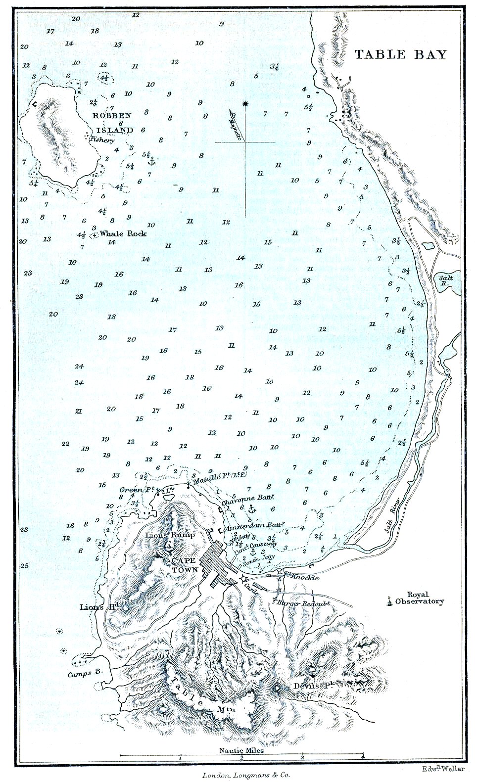
Cape Town & Table Bay 1882.jpg - Julo

Plan of Simons bay near the cape-Good-Hope from observations in augt. and sepr. - btv1b8595656s.jpg - Gzen92Bot