Wikimedi'Òc
Modes d'emploi

Cet album fait partie des albums
Cet album photos contient les sous-albums suivants :


Farallon map old.jpeg - Sabine's Sunbird
Utah and Nevada 1795 BHoU-p27a.png - Moverton

Carte de la Californie 1766.jpg - AndreasPraefcke

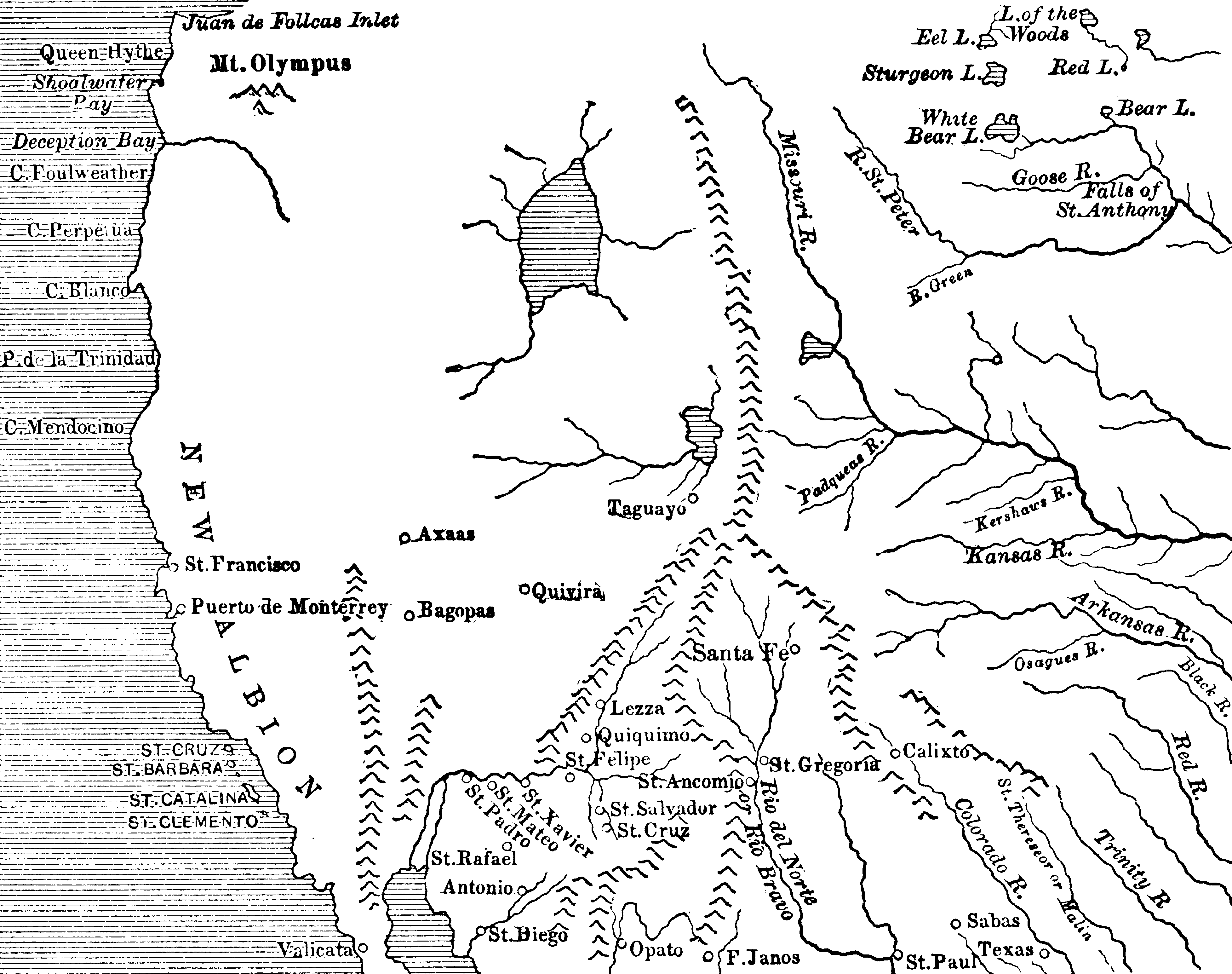
1562 Americæ Gutiérrez.JPG - Kaldari

Deep-water ports on North America's west coast, connected to the rail grid.png - Geo Swan
Auburnfailflood.jpeg - Shannon1

The Overland Route 1908 Map.jpg - File Upload Bot (Magnus Manske)

San Diego Bay, Plan Showing Anchorages and Moorings - NARA - 295436.jpg - US National Archives bot

Pg-23.jpg - William Maury Morris II

Mare Island Plan.jpg - Mwt10485

EB9 California.jpg - Bob Burkhardt

Detalle de Plano de las provincias de Ostimuri, Sinaloa, Sonora y demás provincias circunvecinas y parte de California.png - ImperatorDux

EB1911 California - California and Nevada.jpg - Library Guy

Phylogenetic origins in Antron.png - השואה
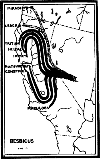
Phylogenetic origins in Besbicus.png - השואה
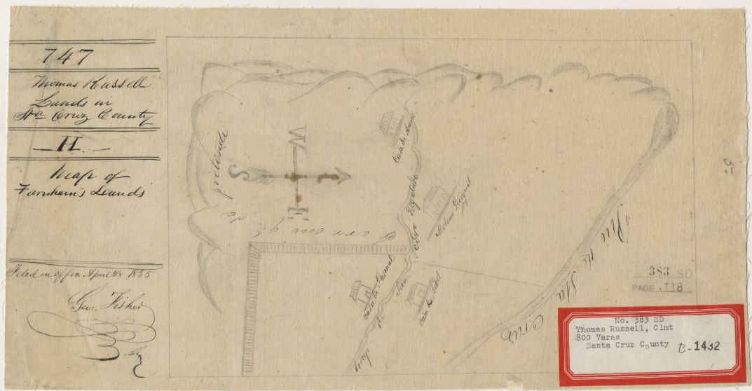
Russell Diseno 1855.png - WCCasey

Annual report of the Laguna Marine Laboratory (1915) (19364625465).jpg - SteinsplitterBot

Annual report of the Bureau of American Ethnology to the Secretary of the Smithsonian Institution (1895) (19355756362).jpg - SteinsplitterBot

Annual report of the Bureau of American Ethnology to the Secretary of the Smithsonian Institution (1895) (19174261268).jpg - SteinsplitterBot

Annual report of the Bureau of American Ethnology to the Secretary of the Smithsonian Institution (1895) (19365889951).jpg - SteinsplitterBot

Animal life in the Yosemite; an account of the mammals, birds, reptiles, and amphibians in a cross-section of the Sierra Nevada (1924) (18199374671).jpg - Fæ

The Spanish in the Southwest (1903) (14595492287).jpg - Faebot

Bulletin (1941) (20237926409).jpg - SteinsplitterBot

Bulletin (1925) (20424273785).jpg - Fæ

Bulletin (1931) (20237471459).jpg - SteinsplitterBot

Bulletin. 1901-13 (20235907148).jpg - Fæ

Bulletin. 1901-13 (20397665686).jpg - Fæ

Bulletin. 1901-13 (20423573985).jpg - Faebot

Bulletin. 1901-13 (20414941642).jpg - Fæ

FMIB 34261 Map of Alamitos Bay Cal.jpeg - BMacZeroBot

FMIB 39084 Typographic map of Monterey Bay, showing submerged valley and probable ancient courses of Pajaro, San Lorenzo, and Salinas Rivers.jpeg - BMacZeroBot

Comstock mining and miners (1883) (20490605029).jpg - Fæ

Fresno County, Cal (1904) (14781488694).jpg - Fæ

The Quarterly journal of the Geological Society of London (1854) (14597038499).jpg - SteinsplitterBot

De Witt's guide to central California; an illustrated and descriptive hand-book for tourists and strangers (1902) (14782656482).jpg - SteinsplitterBot

Ground water in San Joaquin Valley, California (1916) (14782013262).jpg - SteinsplitterBot

Ground water in San Joaquin Valley, California (1916) (14759368996).jpg - SteinsplitterBot

The Commercial and financial chronicle (1911) (14595596757).jpg - Fæ
Bulletin of the U.S. Department of Agriculture (1920) (14801690193).jpg - SteinsplitterBot

California highways; a descriptive record of road development by the state and by such counties as have paved highways (1920) (14595263377).jpg - Ruff tuff cream puff

California highways; a descriptive record of road development by the state and by such counties as have paved highways (1920) (14595124358).jpg - Ruff tuff cream puff

California highways; a descriptive record of road development by the state and by such counties as have paved highways (1920) (14758761176).jpg - Ruff tuff cream puff

California highways; a descriptive record of road development by the state and by such counties as have paved highways (1920) (14801601323).jpg - Ruff tuff cream puff

California highways; a descriptive record of road development by the state and by such counties as have paved highways (1920) (14801578453).jpg - Ruff tuff cream puff

California highways; a descriptive record of road development by the state and by such counties as have paved highways (1920) (14595071658).jpg - Ruff tuff cream puff

California highways; a descriptive record of road development by the state and by such counties as have paved highways (1920) (14779327894).jpg - Ruff tuff cream puff

California highways; a descriptive record of road development by the state and by such counties as have paved highways (1920) (14594969350).jpg - Ruff tuff cream puff

California highways; a descriptive record of road development by the state and by such counties as have paved highways (1920) (14779309334).jpg - Ruff tuff cream puff

California highways; a descriptive record of road development by the state and by such counties as have paved highways (1920) (14778504111).jpg - Ruff tuff cream puff

California highways; a descriptive record of road development by the state and by such counties as have paved highways (1920) (14778489751).jpg - SteinsplitterBot

California highways; a descriptive record of road development by the state and by such counties as have paved highways (1920) (14781635425).jpg - Ruff tuff cream puff

California highways; a descriptive record of road development by the state and by such counties as have paved highways (1920) (14781613645).jpg - Ruff tuff cream puff

California highways; a descriptive record of road development by the state and by such counties as have paved highways (1920) (14779240024).jpg - Ruff tuff cream puff

California highways; a descriptive record of road development by the state and by such counties as have paved highways (1920) (14801447943).jpg - Ruff tuff cream puff

California highways; a descriptive record of road development by the state and by such counties as have paved highways (1920) (14778410751).jpg - Ruff tuff cream puff

California highways; a descriptive record of road development by the state and by such counties as have paved highways (1920) (14779167104).jpg - Ruff tuff cream puff

Pacific service magazine (1924) (14594857969).jpg - Fæ

California highways; a descriptive record of road development by the state and by such counties as have paved highways (1920) (14781046482).jpg - Fæ

Bulletin (1905) (14592852420).jpg - SteinsplitterBot

Pacific Gas and Electric magazine (1912) (14803831523).jpg - Fæ

Journal of electricity, power, and gas (1910) (14584145320).jpg - Fæ

Index to the reports of the chief of engineers, U.S. Army (including the reports of the Isthmian Canal Commissions, (1899-1914) 1866-1912 (1915) (14770110225).jpg - Fæ

Indians of the Southwest (1903) (14765242945).jpg - Faebot

De Witt's guide to central California; an illustrated and descriptive hand-book for tourists and strangers (1902) (14779856501).jpg - Fæ

The city and county of Los Angeles in southern California (1903) (14761302024).jpg - SteinsplitterBot

Resources of the southern San Joaquin Valley, California - Fresno, Tulare and Kern counties - topography, soil, climate, productions, railroads, and general advantages - 1,000,000 acres of government (14738065836).jpg - Fæ

Reports of explorations and surveys, to ascertain the most practicable and economical route for a railroad from the Mississippi River to the Pacific Ocean (1855) (14757106251).jpg - Faebot

Reports of explorations and surveys, to ascertain the most practicable and economical route for a railroad from the Mississippi River to the Pacific Ocean (1855) (14757083871).jpg - SteinsplitterBot
Relief Map of Southern California, California (NYPL b12647398-74484).tiff - Fæ

Providencia Ranch map.png - Universalstonecutter
Map of the states of California and Nevada (NYPL b16807985-1952939).tiff - Fæ

Map of Rancho San Antonio.jpg - Erasmosis

Image taken from page 8 of 'Tourists' Illustrated Guide to the celebrated Summer and Winter Resorts of California adjacent to ... the lines of the Central and Southern Pacific Railroads, etc' (11164528866).jpg - Artix Kreiger 2

86 of '(Scenes of wonder and curiosity in California. Illustrated by upwards of 100 engravings.)' (11245455474).jpg - Artix Kreiger 2

National Forests and National Parks in California (1907).jpg - Animalparty

Map of Railroad Districts of California (1909) a.jpg - Animalparty

Map of Railroad Districts of California (1909) b.jpg - Animalparty
Topographical map of Lake Tahoe and surrounding country LOC 2007633927.tif - Fæ

Topographical map of Lake Tahoe and surrounding country LOC 2007633927.jpg - Fæ
Pinnacles National Monument - T. 16 & 17S. R. 7E LOC 2012588182.tif - Fæ

Pinnacles National Monument - T. 16 & 17S. R. 7E LOC 2012588182.jpg - Fæ
Auburn, Cal. LOC 98680675.tif - Fæ

Auburn, Cal. LOC 98680675.jpg - Fæ

Street and section map of the Los Angeles oil fields, California LOC 2006627664.jpg - Fæ
Carta esférica de la costa de la Alta California - comprendida entre los paralelos de 32° y 38° norte. LOC 2010585365.tif - Fæ

Carta esférica de la costa de la Alta California - comprendida entre los paralelos de 32° y 38° norte. LOC 2010585365.jpg - Fæ

Bird's-eye view of San Pedro, Cal. LOC 88692251.jpg - Fæ
Views of oil fields around Los Angeles LOC 2006627695.tif - Fæ

Views of oil fields around Los Angeles LOC 2006627695.jpg - Fæ
Placer County California LOC 2007633931.tif - Fæ

Placer County California LOC 2007633931.jpg - Fæ
County of Nevada, California LOC 2012586815.tif - Fæ

County of Nevada, California LOC 2012586815.jpg - Fæ
The unique map of California. LOC 99446216.tif - Fæ

The unique map of California. LOC 99446216.jpg - Fæ
Official map of Sutter County, California LOC 2012590097.tif - Fæ

Official map of Sutter County, California LOC 2012590097.jpg - Fæ
Redwood National Park. LOC 75696099.tif - Fæ

Redwood National Park. LOC 75696099.jpg - Fæ
Map of El Dorado County, California LOC 2012586816.tif - Fæ

Map of El Dorado County, California LOC 2012586816.jpg - Fæ
Topographical sketch of the gold & quicksilver district of California. LOC 99446206.tif - Fæ

Topographical sketch of the gold & quicksilver district of California. LOC 99446206.jpg - Fæ
San Mateo Park. LOC 75693111.tif - Fæ
California missions. LOC 2008627969.tif - Fæ

California missions. LOC 2008627969.jpg - Fæ

Map of the city of San Jose LOC 2012593206.jpg - Fæ
Map of the city of Los Angeles - showing railway systems LOC 2006627666.tif - Fæ

Map of the city of Los Angeles - showing railway systems LOC 2006627666.jpg - Fæ
Important historical events which have made Los Angeles' growth possible LOC 2006626013.tif - Fæ

Important historical events which have made Los Angeles' growth possible LOC 2006626013.jpg - Fæ
Map of Napa & Solano Counties, Cal. LOC 2005625301.tif - Fæ

Map of Napa & Solano Counties, Cal. LOC 2005625301.jpg - Fæ
Earthquake shaking potential for California, Spring 2003 LOC 2003683500.tif - Fæ

Earthquake shaking potential for California, Spring 2003 LOC 2003683500.jpg - Fæ
Sketch of General Riley's route through the mining districts (of California) - July and Aug. 1849 LOC 2005625304.tif - Fæ

Sketch of General Riley's route through the mining districts (of California) - July and Aug. 1849 LOC 2005625304.jpg - Fæ
Map of Napa & Solano Counties Cal. LOC 2005625302.tif - Fæ

Map of Napa & Solano Counties Cal. LOC 2005625302.jpg - Fæ
Plan of Sacramento City, State of California LOC 2018588053.tif - Fæ

Plan of Sacramento City, State of California LOC 2018588053.jpg - Fæ
Map of Brookdale, Santa Cruz Co., Cal. being part of Section 32, T.9S. R. 2 W., M.D.M. LOC gm69001757.tif - Fæ

Map of Brookdale, Santa Cruz Co., Cal. being part of Section 32, T.9S. R. 2 W., M.D.M. LOC gm69001757.jpg - Fæ
Map of Los Angeles County - electric, steam railway lines, and mountain guide and also portion of Orange County LOC 2006627661.tif - Fæ

Map of the County of El Dorado, California - compiled from the official records and surveys LOC 2012590101.jpg - Fæ

Official map of Yuba County, State of California - compiled and drawn from official recs. and actual surveys LOC 2012592103.jpg - Fæ
Pictorial map of Fresno County and mid-California's Garden of the Sun. LOC 76690912.tif - Fæ

Pictorial map of Fresno County and mid-California's Garden of the Sun. LOC 76690912.jpg - Fæ
Map of San Fernando Valley, California LOC 2007628013.tif - Fæ

Map of San Fernando Valley, California LOC 2007628013.jpg - Fæ

Official map of the County of Butte, California - carefully compiled from actual surveys LOC 2012590105.jpg - Fæ

Official map of the County of Napa, California - compiled from the official records and latest surveys LOC 2004629168.jpg - Fæ

Map from Sacramento to Virginia Cities and adjoining Northern country - NARA - 93193222.jpg - US National Archives bot

Map of a Reconnaissance of the Colorado River From the Mouth of the Gila - NARA - 93193141.jpg - US National Archives bot

Map of Public Surveys in California - NARA - 109182634.jpg - US National Archives bot

Map of Public Surveys in California - NARA - 109182636.jpg - US National Archives bot

Map of Public Surveys in California - NARA - 109182640.jpg - US National Archives bot

Map of Public Surveys in California - NARA - 109182642.jpg - US National Archives bot

Map of Public Surveys in California - NARA - 109182650.jpg - US National Archives bot

Map of Public Surveys in California - NARA - 109182654.jpg - US National Archives bot

Map of Public Surveys in California and Nevada to Accompany Report of Commissioner of the General Land Office - NARA - 23812140.jpg - US National Archives bot

Map of Public Surveys in California & Nevada - NARA - 109182644.jpg - US National Archives bot

Map of Public Surveys in California & Nevada - NARA - 109182646.jpg - US National Archives bot

Map of Public Surveys in California to Accompany Report of Surveyor General - NARA - 23812157.jpg - US National Archives bot

Map of Public Surveys in California to Accompany Report of Surveyor General - NARA - 23812167.jpg - US National Archives bot

Map of Public Surveys in California to Accompany Report of Surveyor General - NARA - 23812171.jpg - US National Archives bot

Map of Public Surveys in California to Accompany Report of Surveyor General - NARA - 23812172.jpg - US National Archives bot

Map of Public Surveys in California to Accompany Report of Surveyor General - NARA - 23812176.jpg - US National Archives bot

Map of Public Surveys in California to Accompany Report of Surveyor General - NARA - 23812179.jpg - US National Archives bot

Map of Public Surveys in California to Accompany Report of Surveyor General - NARA - 23812195.jpg - US National Archives bot

Map of Public Surveys in California to Accompany Report of Surveyor General - NARA - 23812206.jpg - US National Archives bot

Map of Sebastian Military Reservation - NARA - 109182656.jpg - US National Archives bot

Map of Sierra Valley, California - NARA - 100305691.jpg - US National Archives bot

Map of the State of California - NARA - 23812261.jpg - US National Archives bot

Map of the State of California Showing Lands Designated as Unirrigable by the Secretary of the Interior under the Provisions of the Enlarged Homestead Act - NARA - 23812284.jpg - US National Archives bot

Map of the State of California Showing Lands Designated by the Secretary of the Interior under the Provisions of the Enlarged Homestead Act - NARA - 23812281.jpg - US National Archives bot

Map showing area around Los Angeles, California - NARA - 100305840.jpg - US National Archives bot

Map showing area between Honey Lake, California and Lake Tahoe - NARA - 100305718.jpg - US National Archives bot

Le Tour du monde-05-p003.jpg - Bzhqc

Le Tour du monde-05-p251.jpg - Bzhqc

Tulare Township West Side Irrigation (1877 Map).png - BayRadioDJ

Admiralty Chart No 2530 Diego Bay to Cape Mendocino, Published 1858.jpg - Kognos

1897-topo-map-morro-bay-4841-2041x2660 (5544645420).jpg - Geo Swan

Map of Rancho San Francisco.jpg - Ad17minstral

Map of Santa Anita.jpg - Ad17minstral

The Centennial History of Oregon - Dutch Map.png - Sp1nd01

Map of passes in the Sierra Nevada from Walker's Pass to the Coast Range from explorations and surveys master-gmd-gmd436-g4360-g4360-rr001500.jpg - Kognos

Map of Camp Wright, Round Valley, and Vicinity - DPLA - 9a87dabf8c1c4a1ce4edab87f7c011f2.jpg - DPLA bot

Southern California 1858 Military Department of California.jpg - Jengod
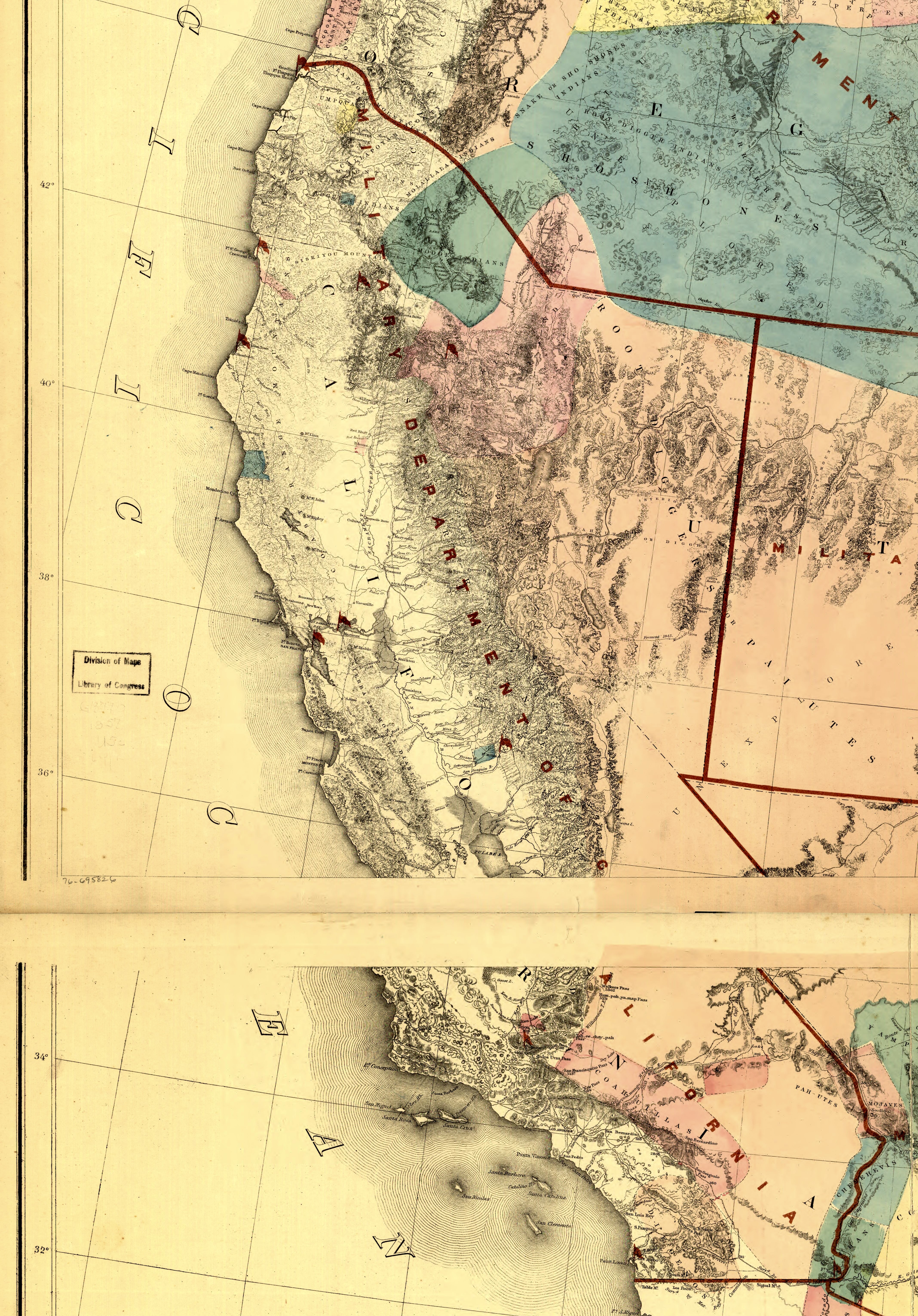
Military department of California 1858.jpg - Jengod
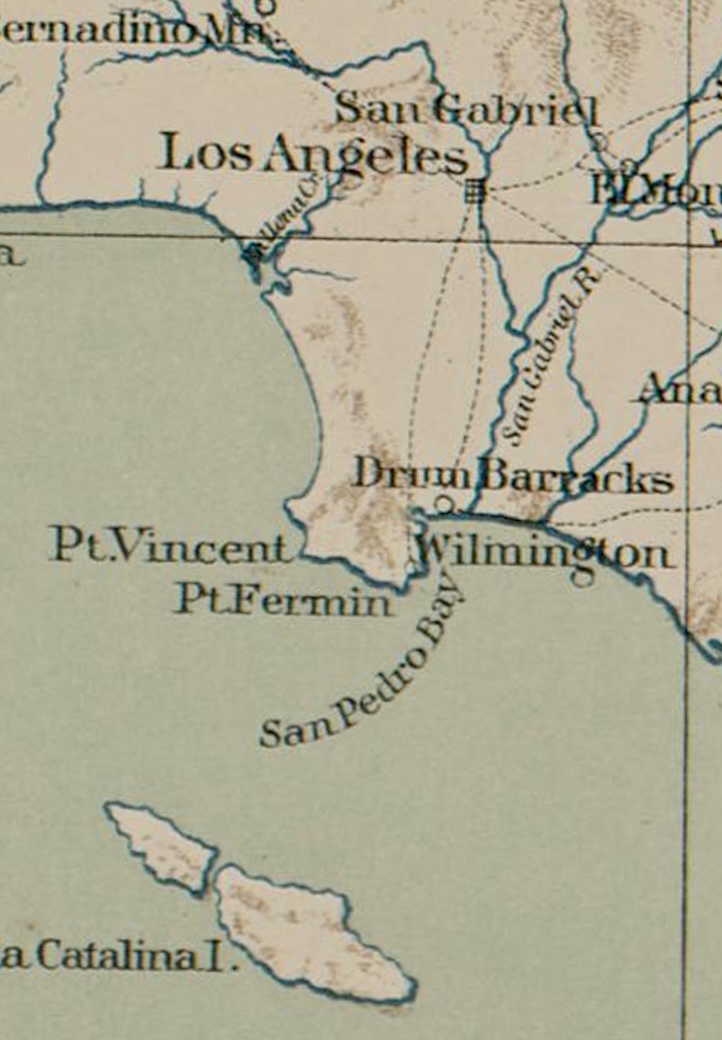
Southern California 1867 American Civil War.jpg - Jengod

California in 1846 map of Spanish and Mexican land grants.jpg - Jengod

Map of Selected Site for Indian Reservation in Mendocino County, California - DPLA - 0f1f12d9527df1104984c8452d623995.jpg - DPLA bot
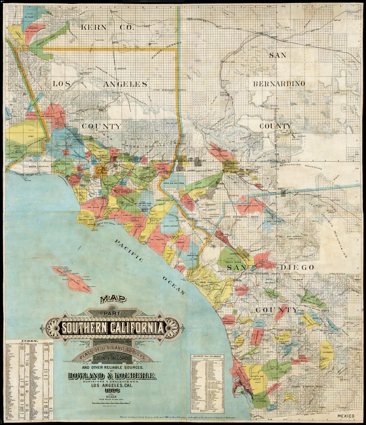
Ranchos of Sothern California 1886.jpg - Telecineguy
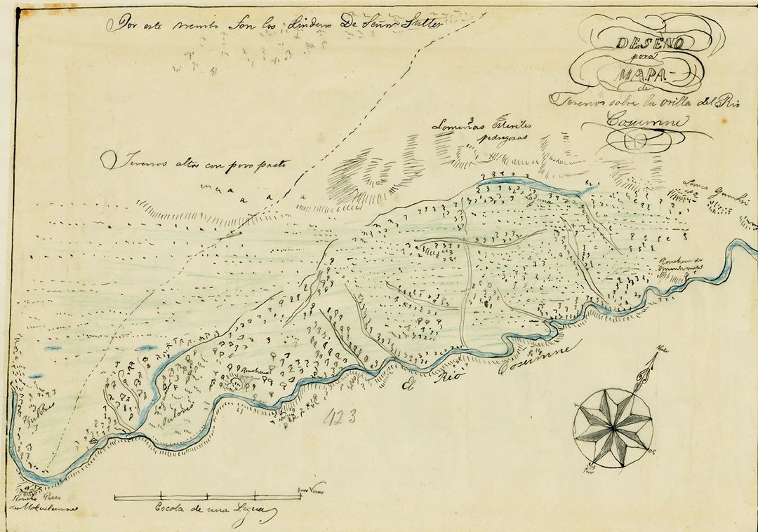
Rancho Omochumnes1844 map.jpg - Telecineguy

CityofStockton1895.jpg - Telecineguy
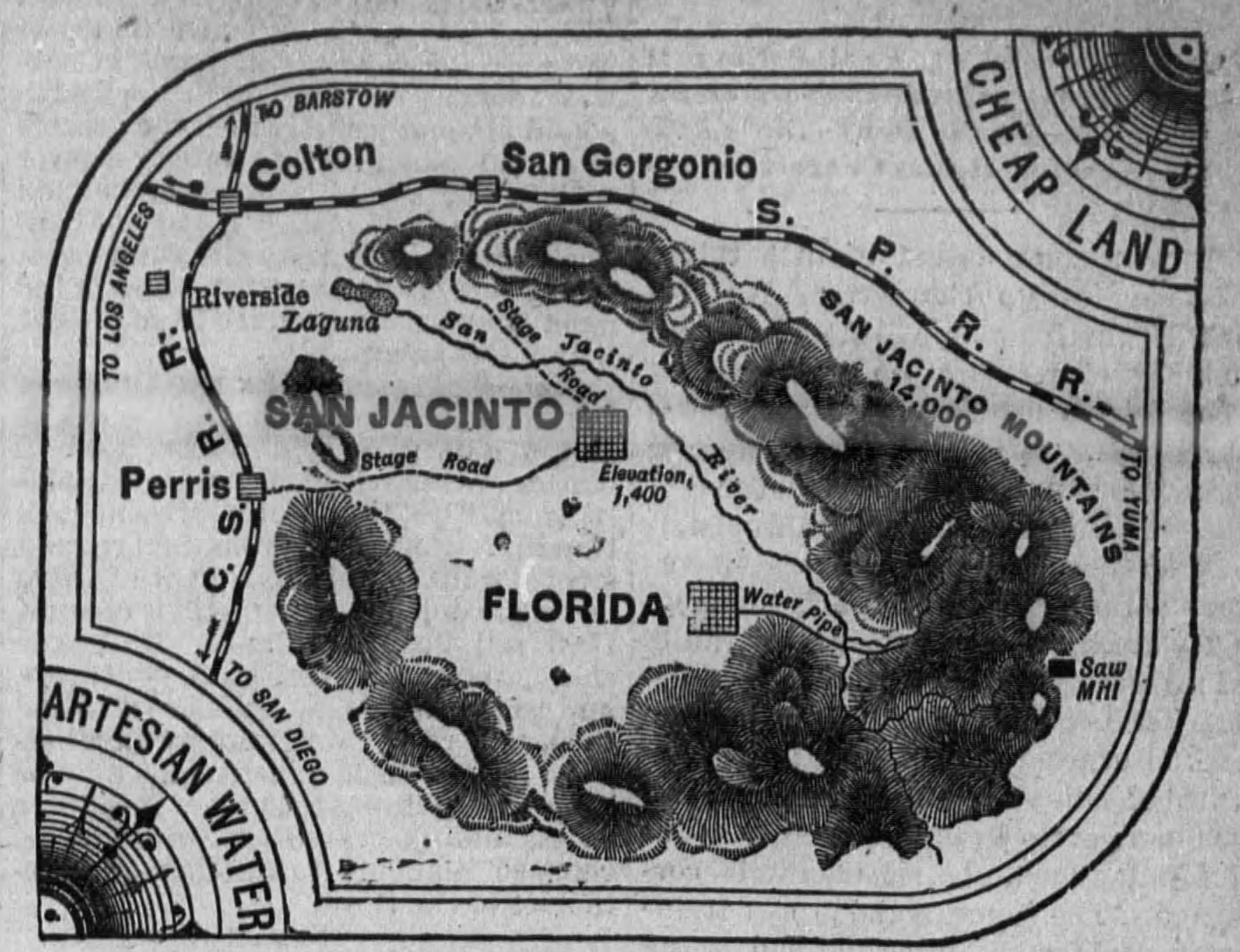
Artesian Water and Cheap Land in the Great San Jacinto Valley.jpg - Jengod

Map of Higgins Point.png - Oona Wikiwalker
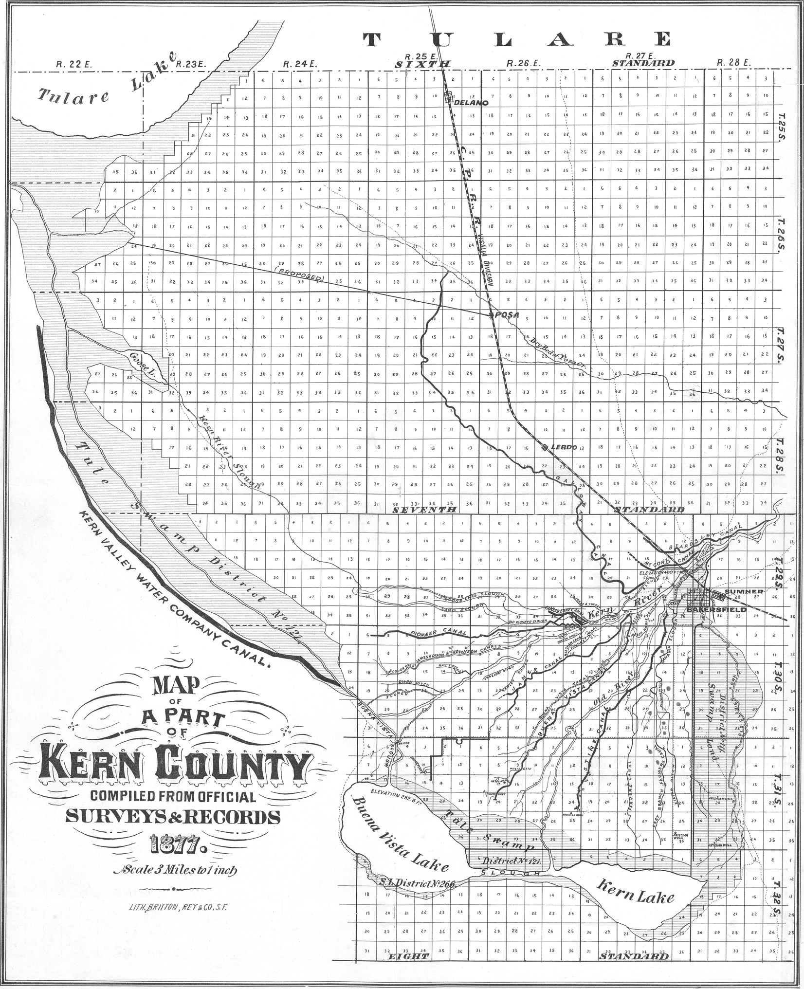
Kern County Map, 1877.png - Oona Wikiwalker

Admiralty Chart No 3122 Redding Rock to Cape Blanco, Published 1900.jpg - Kognos

Pictorial and Historical map of Old Los Angeles County 1938 by George W. Kirkman.jpg - Jengod

UCLA Library G4363 L.A. Co. ca. 400 HJS 1880 OCLC 24883504.jpg - Jengod

San Bernardino 1938.jpg - Marsonmars

Calexico 1938.jpg - Marsonmars

Anaheim 1938.jpg - Marsonmars

Santa Monica 1938.jpg - Marsonmars