Wikimedi'Òc
Modes d'emploi

Cet album fait partie des albums
Cet album photos contient les sous-albums suivants :


Harborne Village 1834.jpg - Pigsonthewing

Smethick Alcester & Broom Walsall RJD 89.jpg - Irate

Birmingham & Bordesley RJD 7.jpg - Rstory

Witton Cemetery OS 25 inch 1903.jpg - Oosoom

Key Hill Cemetery OS 25 inch 1903.jpg - Oosoom

Warstone Lane Cemetery OS 25 inch 1903.jpg - Oosoom

1731 Birmingham street plan.jpg - File Upload Bot (Magnus Manske)

Austin Village OS map 1936 1 2500 25 inch.jpg - Oosoom

Birmingham - Westley Map 1731.png - File Upload Bot (Magnus Manske)

Gough Map Birmingham.jpg - JimmyGuano

Birmingham Moat 1731.jpg - JimmyGuano

Corporation Street dual strip 1890 and 1937.png - Oosoom
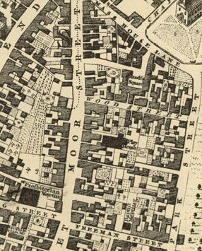
Moor-Street-Theatre-1751.jpg - JimmyGuano

Birmingham OS 1834 map.JPG - Pahazzard

Ashford death field.png - Ciaurlec

Castlle Bromwich Exhbition Hall OS 1st ed 1-25.png - Pigsonthewing

Monument Lane Station map w3200.jpg - Oosoom
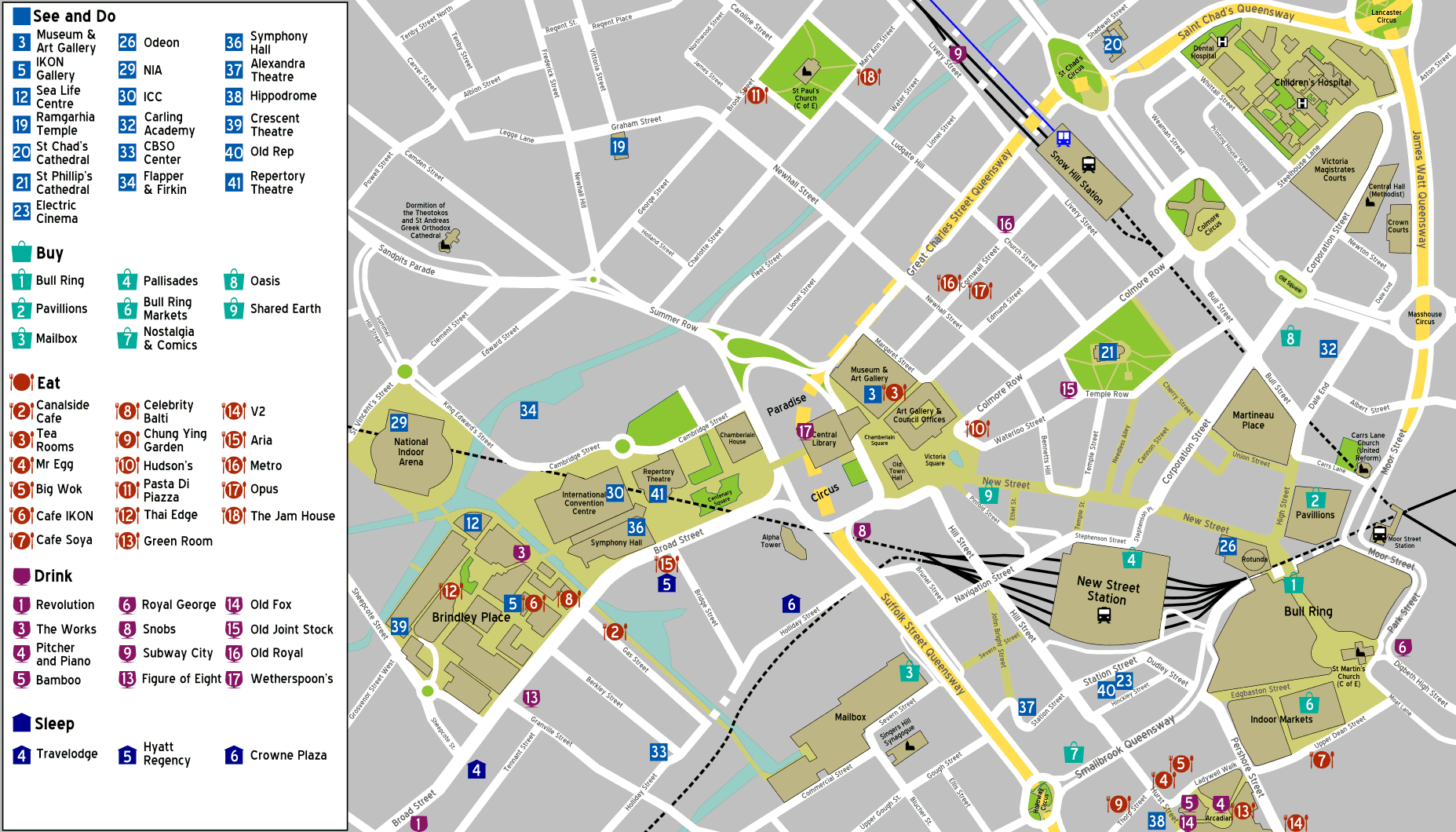
Birmingham UK city centre map.png - MGA73bot2

Birmingham England 1839.jpg - National Public Domain Archive

Ordnance Survey Drawings - Birmingham (OSD 256).jpg - LibraryBot

Map of The Crescent, Birmingham 1888-9.jpg - Pigsonthewing

Map of The Crescent, Birmingham 1904-5.jpg - Pigsonthewing

Map from An history of Birmingham.jpg - Flickr upload bot
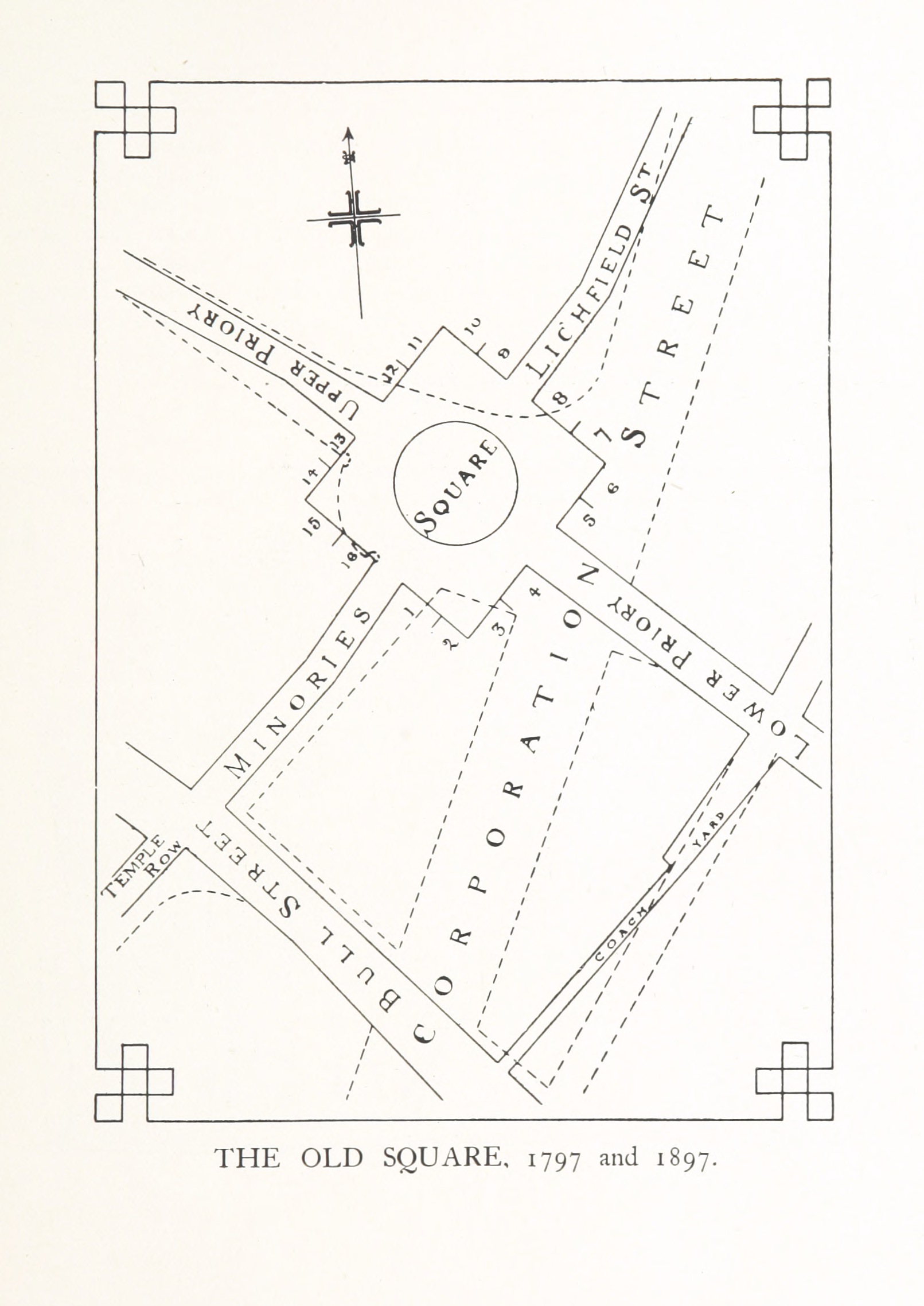
Old Square, Birmingham 1797 + 1897.jpg - Flickr upload bot

Roscoe L&BR(1839) p231 - Map of Birmingham.jpg - Jheald

Roscoe GJR(1839) p186 - Map of Birmingham.jpg - Jheald

EW(1884) p.320 - Birmingham (left) - A + C Black (pub).jpg - Jheald

EW(1884) p.321 - Birmingham (right) - A + C Black (pub).jpg - Jheald

EW(1884) p.320 - Birmingham (merged) - A + C Black (pub).jpg - Jheald

BRADSHAW(1854) p186 BIRMINGHAM.jpg - Metilsteiner

BRADSHAW(1854) p184 MAP OF THE DISTRICT BETWEEN LONDON, BIRMINGHAM AND LEICESTER.jpg - Metilsteiner

Birmingham Worcester Wharf Central Goods Depot OS map 2nd edition 1905.png - Oosoom

Birmingham Worcester Wharf Central Goods Depot OS map 2nd edition 1905 showing canals rail tunnels and Central Goods and New Street stations.jpg - Oosoom

Aa before birmingham uk airport.jpg - Arash.pt
Transactions of conference held March 9 to 13, 1914, at Liberty buildings, Liverpool (1914) (14784773895).jpg - Fæ

A Walloon family in America; Lockwood de Forest and his forbears 1500-1848 (1914) (14763831754).jpg - Fæ

The Encyclopaedia Britannica; A dictionary of arts, sciences and general literature (1902) (14781744284).jpg - Fæ

The imperial gazetteer of England and Wales - embracing recent changes in counties, dioceses, parishes, and boroughs- general statistics- postal arrangements- railway systems, etc and forming a (14573528698).jpg - Fæ

Colmore-Row-1731.jpg - FastilyClone
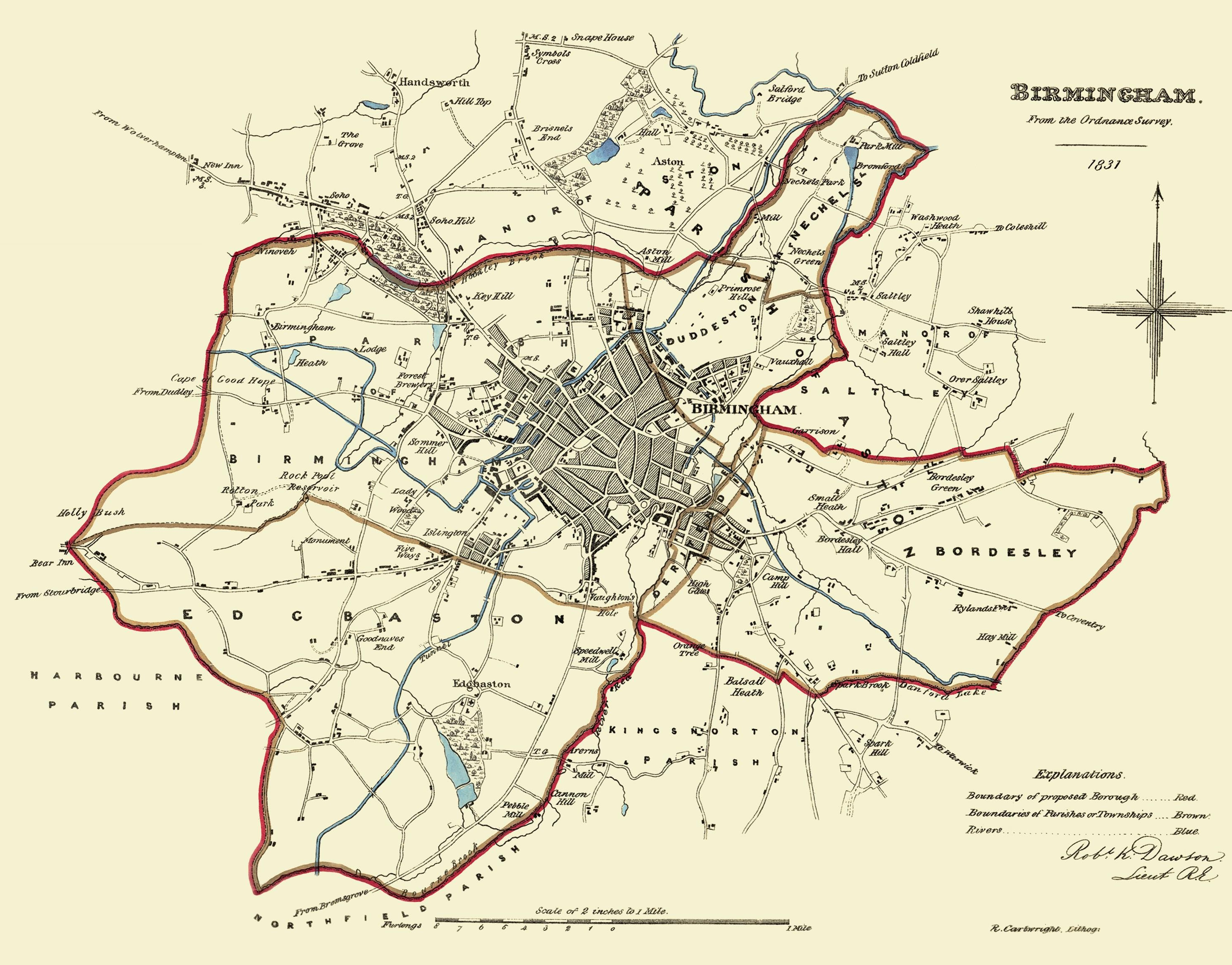
Birmingham - Reform Act Map 1831.png - FastilyClone

665 of '(An history of Birmingham ... With a new introduction by Christopher R. Erington.)' (11001222735).jpg - Artix Kreiger 2

34 of 'Memorials of the Old Square- being some notices of the Priory of St. Thomas in Birmingham ... also of the Square built upon the Priory Close, etc. (With illustrations.) L.P' (11241683135).jpg - Artix Kreiger 2

Page 10 of '(The Birmingham Saturday half-holiday guide, with a map. (By Joseph Sturge.))' (11204255523).jpg - Artix Kreiger 2

11 of '(The Birmingham Saturday half-holiday guide, with a map. (By Joseph Sturge.))' (11205051513).jpg - Artix Kreiger 2

109 of '(The Birmingham Saturday half-holiday guide, with a map. (By Joseph Sturge.))' (11204286524).jpg - Artix Kreiger 2

18 of '(The Birmingham Saturday half-holiday guide, with a map. (By Joseph Sturge.))' (11218887296).jpg - Artix Kreiger 2

443 of '(The Imperial Gazetteer; a general dictionary of geography, physical, political, statistical and descriptive ... Edited by W. G. Blackie ... With ... illustrations, etc.)' (11103723586).jpg - Artix Kreiger 2

82 of 'The British Empire- its geography, resources, commerce, land-ways and water-ways' (11122624264).jpg - Artix Kreiger 2

118 of 'A New Geography on the comparative method. With maps and diagrams' (11109616303).jpg - Artix Kreiger 2

199 of 'The International Geography. ... Edited by H. R. Mill' (11289614266).jpg - Kilom691

290 of '(Our own country. Descriptive, historical, pictorial.)' (11176119256).jpg - Artix Kreiger 2

300 of '(Our own country. Descriptive, historical, pictorial.)' (11174505313).jpg - Artix Kreiger 2

290 of '(Our own country. Descriptive, historical, pictorial.)' (11245017105).jpg - Artix Kreiger 2

148 of 'The Earth and its Inhabitants. The European section of the Universal Geography by E. Reclus. Edited by E. G. Ravenstein. Illustrated by ... engravings and maps' (11127581064).jpg - Artix Kreiger 2

Ordnance Survey One-Inch Sheet 72 Birmingham, Published 1921.jpg - Kognos

Outer Circle Guide - centrefold map.jpg - Pigsonthewing
Map of Birmingham, Alabama and adjacent suburbs. LOC 73696177.tif - Fæ

Map of Birmingham, Alabama and adjacent suburbs. LOC 73696177.jpg - Fæ

Ordnance Survey Half-inch Sheet 23 Birmingham Leamington & Northampton, Published 1925.jpg - Kognos

St Mary's Church, Whittall Street, Birmingham - OS 25 inch 1892-1914 02.png - Pigsonthewing

Birmingham General Hospital - OS 25 inch 1892-1914 01.png - Pigsonthewing

Birmingham England 1839 (cropped - New Street Station area).jpg - Pigsonthewing

Halesowen & Northfield RJD 21.jpg - Pigsonthewing

Bradshaw's Railway Timetables 1839 - Birmingham.jpg - Sp1nd01

Bradshaw's Railway Comanion - 1840 - Birmingham map.webp - Pigsonthewing

Ganow Green - Frankley - OS 1921 - 1279228725.jpg - Pigsonthewing

Bisset's Magnificent Guide - James Bisset - 1808 - 03 - 83-0-657x1024.jpg - Pigsonthewing

Balsallheath.JPG - Aynuk N. Ayli

Ordnance Survey Unions, Litchfield - 1830-1840.png - Pigsonthewing

Plan of Birmingham by Thomas Hanson (1778).jpg - Pigsonthewing
Plan of Birmingham by Thomas Hanson (1778) (cropped for St Mary's Church).jpg - Pigsonthewing
Windsor street gasworks 1967.png - Dumelow

Birmingham Market Hall + environs - OS 25 inch 1892-1914.png - Pigsonthewing

A Century of Birmingham Life - p44.png - Sp1nd01

The Encyclopaedia Britannica 1902 - Map of suburbs of Birmingham.png - Sp1nd01

The Encyclopaedia Britannica 1902 - Plan of Central Birmingham.png - Sp1nd01

Blue Coat School Birmingham Map 1918.jpg - Bungle

Map of Birmingham issued with Allday's Gossiping Guide - btv1b8459864x.jpg - Gzen92Bot

Birmingham Improvement Scheme map - circa 1876.jpg - Pigsonthewing

A Plan of Birmingham.jpg - Ardfern

Seat of Lord Birmingham, 1721.jpg - Ardfern

Plan of Birmingham, 1731.jpg - Ardfern

Map from Birmingham Corporation Inner Ring Road Key Plan, 1946.jpg - Pigsonthewing

Samuel Bradford’s 1751 survey of Birmingham (3832x3045).jpg - Pigsonthewing

Aston Lower Grounds, 1887.png - In Vitrio

Aston Lower Grounds, circa 1888.png - In Vitrio

Ordnance Survey - Staffordshire Sheet LXIX.NW - 1884.png - Pigsonthewing

Ordnance Survey - Staffordshire Sheet LXIX.NW - 1884 (The Beeches).png - Pigsonthewing

Ordnance Survey - Staffordshire Sheet LXVIII.NE - 1886.png - Pigsonthewing

Ordnance Survey - Staffordshire Sheet LXVIII.NE - 1886 (St Paul's Church).png - Pigsonthewing

Ordnance Survey - Staffordshire Sheet LXVIII.SE - 1890.png - Pigsonthewing

Ordnance Survey - Staffordshire Sheet LXIX.SW - 1889.png - Pigsonthewing

Ordnance Survey - Staffordshire Sheet LXIX.SW - 1889 (cropped - Aston Lower Grounds).png - Pigsonthewing