Wikimedi'Òc
Modes d'emploi

Cet album fait partie des albums
Cet album photos contient les sous-albums suivants :


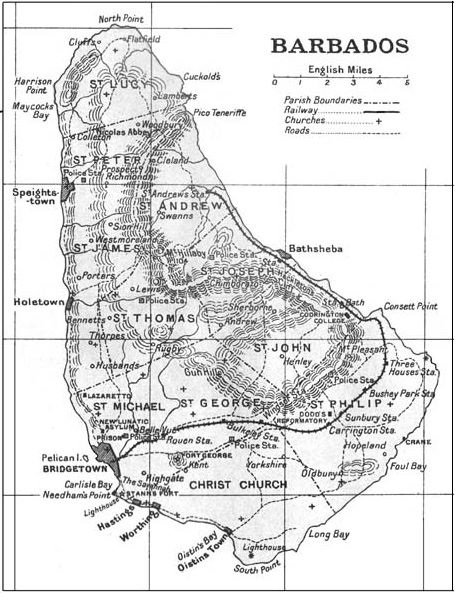
MapOfBarbados1750.jpg - Victuallers

1780 Raynal and Bonne Map of the Virgin Islands and Antilles, West Indies - Geographicus - Antilles-bonne-1780.jpg - BotMultichillT

Pg300 Map of the Caribbee Islands to the year 1536.jpg - Metilsteiner

Pg580 Fig1 Section fromnear Paynes Bay to Chalky Mount.jpg - Metilsteiner

Pg581 Fig3 Map of the Central Ridge.jpg - Metilsteiner

Pg580 Fig2 Section from South Point through the Rising Sun and the Valley.jpg - Metilsteiner

Pg585.jpg - Metilsteiner

Map of Antigua, Barbados, St.Kitts and Dominica (1888).jpg - Metilsteiner
Novissima et Acuratissima Barbados. Descriptio per Johannem Ogiluium Cosmographum Regium NYPL1505041.tiff - Fæ

The pocket guide to the West Indies, British Guiana, British Honduras, the Bermudas, the Spanish Main, and the Panama canal (1914) (14802455523).jpg - SteinsplitterBot

The pocket guide to the West Indies, British Guiana, British Honduras, the Bermudas, the Spanish Main, and the Panama canal (1914) (14759601376).jpg - SteinsplitterBot

The pocket guide to the West Indies, British Guiana, British Honduras, the Bermudas, the Spanish Main, and the Panama canal (1914) (14759573766).jpg - Fæ

The pocket guide to the West Indies, British Guiana, British Honduras, the Bermudas, the Spanish Main, and the Panama canal (1914) (14759575126).jpg - Fæ

The natural history of Barbados - in ten books (1750) (14595063867).jpg - SteinsplitterBot
Algernon Aspinall 'The Pocket Guide to the West Indies'. 515 pages. New York, 1923.jpg - NearEMPTiness
Barbados. LOC 84694193.tif - Fæ

Barbados. LOC 84694193.jpg - Fæ
Barbados. 9-69. LOC gm70003364.tif - Fæ

Barbados. 9-69. LOC gm70003364.jpg - Fæ
Barbados. 9-69. LOC gm70003365.tif - Fæ
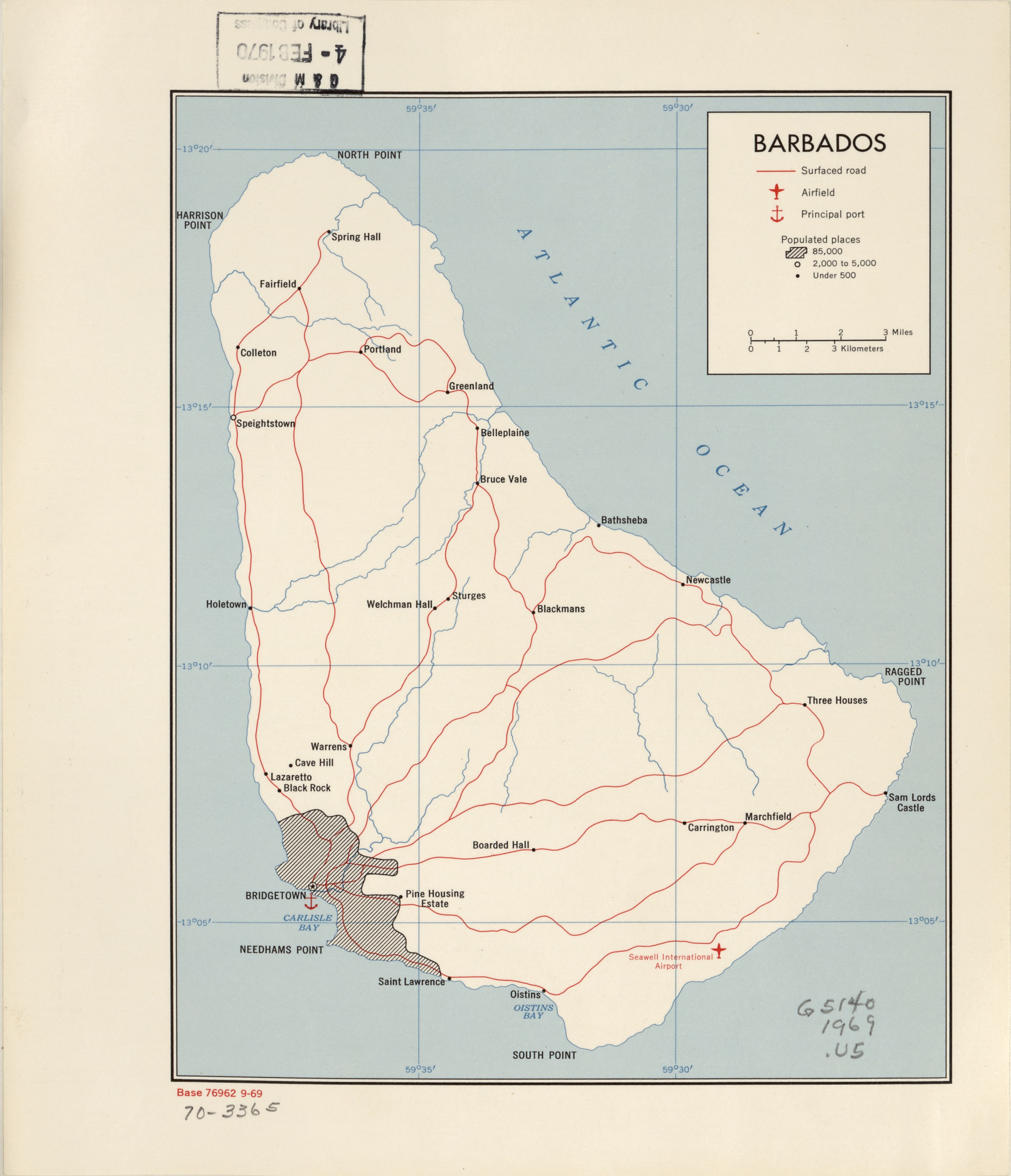
Barbados. 9-69. LOC gm70003365.jpg - Fæ
Barbados. LOC 2005631607.tif - Fæ

Barbados. LOC 2005631607.jpg - Fæ

Map of Barbados Thomas Jefferys 1750.jpg - Fernandezmv
Carte de l'isle de la Barbade. LOC 73697230.tif - Fæ
Carta de la isla de la Barbada, LOC 73697189.tif - Fæ

Carta de la isla de la Barbada, LOC 73697189.jpg - Fæ
Insula Barbadoes in suas parochias distincts, una cum oris maritimis, vüs etc. ad fidem Anglicani authoris delineata. LOC 74691682.tif - Fæ
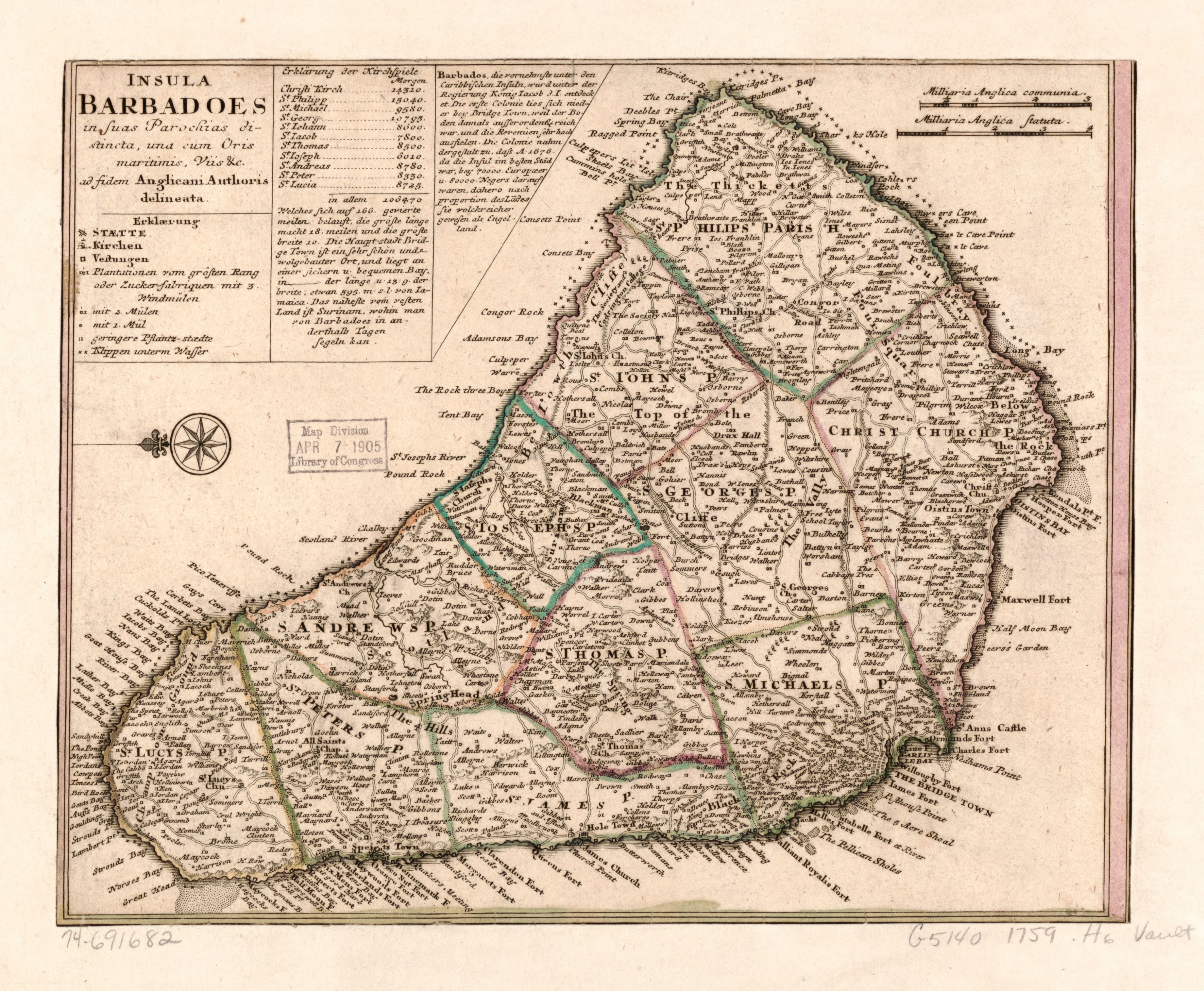
Insula Barbadoes in suas parochias distincts, una cum oris maritimis, vüs etc. ad fidem Anglicani authoris delineata. LOC 74691682.jpg - Fæ

Paskaart van een deel van de Bovenwindse Eilanden, met Barbados Pas kaart van de Caribes tusschen I. Barbados en I. S. Martin (titel op object), RP-P-1896-A-19368-3088.jpg - Mr.Nostalgic

Admiralty Chart No 956 Guadeloupe to Trinidad, Published 1886.jpg - Kognos

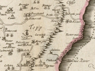
Paleologus and Beal map.png - Ichthyovenator
A new map of the Island of Barbadoes (IA McGillLibrary-129997-5079).pdf - Fæ
The earliest printed map of Barbados by Richard Ligon, 1657, KITLV 1407468.tiff - Finavon

A New map of the island of Barbadoes... - by P. Lea - btv1b53122241n.jpg - Gzen92Bot

Barbados Railway drawn by W. F. Burnett, 1921.jpg - NearEMPTiness

Admiralty Chart No 502 Plans in Barbados, Published 1963.jpg - Kognos

Approaches to Bridgetown cropped from Admiralty Chart No 502 Plans in Barbados, Published 1963.jpg - Kognos