Wikimedi'Òc
Modes d'emploi

Cet album fait partie des albums


Bengal gazetteer 1907-9.jpg - Furfur

Eaglenest Topo.jpg - Marcus334

Ahom-kingdom-c1826p.png - Chaipau
Cooch Behar from 1931 Imperial Gazetteer.jpg - Aymatth2

British India 1940 Assam Bihar Sikkim Arunachal Pradesh Mizoram Nagaland Tripura Burma Bhutan Map.jpg - Flickr upload bot

'Front of Tibet' Map Painted by Wu Run-De (1907).jpg - Pratyeka

A Statistical Account of Assam — Volume 1 Map.jpg - Samiur Rahman 2017

A Statistical Account of Assam — Volume 2 Map.jpg - Samiur Rahman 2017

Image taken from page 1381 of 'La Terra, trattato popolare di geografia universale per G. Marinelli ed altri scienziati italiani, etc. (With illustrations and maps.)' (16404241529).jpg - Artix Kreiger 2
100 of 'Topography of Assam' (11013756714).jpg - FlickreviewR 2

725 of 'Dictionnaire des sciences anthropologiques ... publié sous la direction de A. Bertillon, Coudereau, A. Hovelacque, Issaurat (and others), etc' (11088326715).jpg - Artix Kreiger 2

177 of 'Petroleum- a treatise on the geographical distribution and geological occurrence of petroleum and natural gas ... By B. Redwood, assisted by G. T. Holloway, and other contributors ... With maps, etc' (11238563044).jpg - FlickreviewR 2

Assam 1891.jpg - Shyamal
Assam. 7-69. LOC gm70003328.tif - Fæ

Assam. 7-69. LOC gm70003328.jpg - Fæ

Map of Tibet in 1921, In farthest Burma - the record of an arduous journey of exploration and research through the unknown frontier territory of Burma and Tibet (1921) (cropped).jpg - Tibet Nation

1891 Skeleton map of Assam and Burmah (SoI).jpg - Kautilya3

Map of Tibet "THIBET" in 1844 with "LITTLE THIBET" from- China and Japan, John Nicaragua Dower (1844) (cropped).jpg - Tibet Nation

Map of Tibet in 1897, from- A cycle of Cathay, or, China, south and north (1897) (14595649540) (cropped).jpg - Tibet Nation

Txu-oclc-6654394-ng-46-6th-ed.jpg - Geographyinitiative

"LOCATION DIAGRAM FOR NH 46-14" "SERIES L500" within Tibet, Sikang, India in 1954 map detail, from- Txu-oclc-10552568-nh46-14 (cropped).jpg - Tibet Nation

McMahon Line on 1936 Survey of India map of Tibet.jpg - Kautilya3

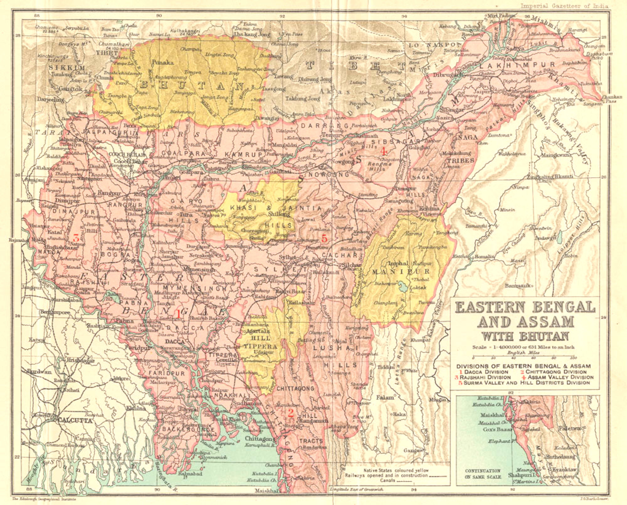
Easter Bengal and Assam with Bhutan.jpg - Rnrctg

Rengma Hills According to John Butler 'Travels of Assam'.jpg - Paul N Rengma

Txu-pclmaps-oclc-181831961-82-p-nizamghat-1927.jpg - Kautilya3

Txu-pclmaps-oclc-181831961-83-m-sadiya-1942.jpg - Kautilya3

Txu-pclmaps-oclc-181831961-83-n-myitkyina-1944.jpg - Kautilya3

Txu-pclmaps-oclc-181831961-82-p-nizamghat-1943.jpg - Kautilya3

Txu-pclmaps-oclc-181831961-83-m-sadiya-1919.jpg - Kautilya3

Txu-pclmaps-oclc-181831961-83-m-sadiya-1930.jpg - Kautilya3

1888 Survey of India map of Assam and the Himalayan region.jpg - Kautilya3

Zones de théiculture de l'Assam, 1873.jpg - Scewing

Sketch map illustrating the extent of the Assamese kingdom in their zenith.png - ComparingQuantities

SoI map 83-H Assam Burma.jpg - Kautilya3

Txu-pclmaps-oclc-181831961-83-h-imphal-1944.jpg - Kautilya3

Sheet-83-dibrugarh-1924.jpg - Kautilya3

1946 National Geogapic map of Bengal and Assam.jpg - Kautilya3

1946 National Geographic map of Northeast India.jpg - Kautilya3

Map of Lushai Tribes.jpg - Taitesena

16 of 'Hunting in the Himalaya. With notices of customs and countries from the elephant haunts of the Dehra Doon to the Bunchowr tracks in eternal snow. Illustrated by J. Wolf' (11060255234).jpg - Artix Kreiger 2