Wikimedi'Òc
Modes d'emploi

Cet album fait partie des albums
Cet album photos contient les sous-albums suivants :


USA Nemaha County, Kansas age pyramid.svg - DieBucheBot
KSMap-doton-Goff.png - SieBot
KSMap-doton-Oneida.png - SieBot
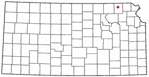
KSMap-doton-Seneca.png - SieBot
KSMap-doton-Wetmore.png - SieBot

America City Cemetery.JPG - Bhall87
Historic American Buildings Survey Dick Hughes, Photographer September 1965 SOUTH EAST CORNER - Albany Schoolhouse, 2 miles north of Sebetha, Sabetha, Nemaha County, KS HABS KANS,66-ALB,1-1.tif - Fæ
Historic American Buildings Survey Dick Hughes, Photographer September 1965 SOUTHEAST CORNER - Albany Schoolhouse, 2 miles north of Sebetha, Sabetha, Nemaha County, KS HABS KANS,66-ALB,1-2.tif - Fæ
Historic American Buildings Survey Dick Hughes, Photographer September 1965 SOUTHWEST CORNER - Albany Schoolhouse, 2 miles north of Sebetha, Sabetha, Nemaha County, KS HABS KANS,66-ALB,1-3.tif - Fæ
Historic American Buildings Survey Dick Hughes, Photographer September 1965 FIRST FLOOR (Desks Face West) - Albany Schoolhouse, 2 miles north of Sebetha, Sabetha, Nemaha County, HABS KANS,66-ALB,1-5.tif - Fæ
Historic American Buildings Survey Dick Hughes, Photographer September 1965 NORTHEAST CORNER - Albany Schoolhouse, 2 miles north of Sebetha, Sabetha, Nemaha County, KS HABS KANS,66-ALB,1-4.tif - Fæ
Historic American Buildings Survey Dick Hughes, Photographer September 1965 FIRST FLOOR (Looking East) - Albany Schoolhouse, 2 miles north of Sebetha, Sabetha, Nemaha County, KS HABS KANS,66-ALB,1-6.tif - Fæ
Historic American Buildings Survey Dick Hughes, Photographer September 1965 SECOND FLOOR (Pews Face East) - Albany Schoolhouse, 2 miles north of Sebetha, Sabetha, Nemaha County, HABS KANS,66-ALB,1-7.tif - Fæ
Historic American Buildings Survey Dick Hughes, Photographer September 1965 SECOND FLOOR (Looking West) - Albany Schoolhouse, 2 miles north of Sebetha, Sabetha, Nemaha County, KS HABS KANS,66-ALB,1-8.tif - Fæ

Detailed map of Seneca, Kansas.png - GifTagger

Goff National Bank.jpg - Bhall87